CODOS Update -
Clean snowcover so far, interesting early winter hydrology
Greetings from Silverton, the Center for Snow, and CODOS as we begin calendar year 2014.
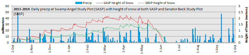
Here in the San Juan Mountains, New Year’s dawn arrived with a skiff of new snow, clearing morning skies, and spectacular banners of blowing snow flagging off the peaks, on NW winds. Despite a snowy start to winter, our mountains had begun to look “bony” during the past couple of weeks, so even an inch of new snow produces a welcome, if temporary, touch-up to the landscape. Nonetheless, the regional snowpack hovers at near-normal values, thanks to the eight numbered winter storms we’ve received so far. Basins farther north are also in good shape. The chart below documents this Water Year 2014’s weather to-date at Senator Beck Basin, by day, showing the water equivalent of precipitation at Swamp Angel Study Plot and height of snow there and at the alpine, wind-effected Senator Beck Study Plot. Charts for Water Years 2005-2013 are also presented, for comparison, at https://www.snowstudies.org/data/graphs/precip.html#HS.
Better still, we have entered 2014 with a snowcover free of any dust layers here at the Senator Beck Basin Study Area at Red Mountain Pass, in spite of a couple of very windy early winter storms. The absence of dust here is a pretty reliable indicator that other parts of the Colorado mountains have not yet received any Colorado Plateau dust either, and we’ve heard no reports of CP dust from our fellow snow observers. With over 80 dust-on-snow events now in our CODOS Dust Log, since the winter of 2004/2005, a striking pattern in dust-on-snow event timing has emerged, as seen in the graph below.
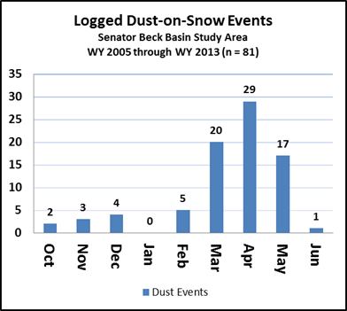
This is the first season since WY 2005 that we have not received at least one early winter dust-on-snow layer in Oct/Nov/Dec, perhaps a function of the wet weather throughout the Southwest last fall. And, although we came very close two years ago, with event D3 on December 31, 2011, we have yet to log a single January dust-on-snow event.
As the graph clearly shows, and as we’ve described it, ‘dust season’ has been predominately March/April/May, with 66 of the 81 events logged and the vast majority of actual dust mass deposited. Interestingly, that period is also responsible for the final one-third of our average winter precipitation total, with the October-February period producing the balance. As a result, the vast majority of our dust, on average, has been deposited near the top of our snowcover, with the majority of snowcover and SWE lying beneath several dust layers and, therefore, subject to the reductions in snow albedo produced by that dust. Further, many seasons have seen large dust-on-snow events deposited in May along with the final addition of snow at the very top of the snowpack.
After our lowest level of cumulative snowmelt discharge in our period of record, through July 2013, this fall and early winter also produced another unusual feature in our Senator Beck Basin mountain system monitoring dataset. Almost certainly as a result of heavy rains during our very wet late summer and early fall, and perhaps supplemented by snowmelt following Winter Storms #1 and 2, our Senator Beck Stream Gauge recorded unusually prolonged, relatively high stream flow levels well beyond the date when we typically see those flows decline to trickling “base flows” (see below). In fact, flows remained so vigorous this season that we were able to continue operating our stream monitoring instrumentation a full month longer than in any prior season, until December 27th, before ice formation in the stream gauge’s pool threatened damage to those instruments.
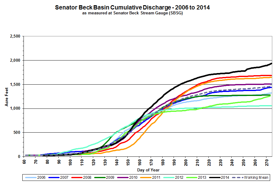
Comparatively strong fall and early winter flows in our Uncompahgre River watershed resulted in significant “bonus” acre feet of storage at Ridgway Reservoir and similar effects may have benefited other Colorado reservoirs. It seems that those relatively high flows were triggered by unusually heavy rain precipitation, especially in September (5.8” in Sept. 2013, versus our period of record mean of 3.4”), perhaps supplemented by snowmelt from sunny aspects following Winter Storm #1, early in October, and even Storm #2. Veteran snow observers can recall when Colorado snowpack formation often began in September at high elevations like Senator Beck Basin. If this fall’s rains exemplified the anticipated continued shift in phase of early season precipitation caused by regional climate warming, with fall storms changing from snow to rain events, then perhaps the resulting increase in over-winter reservoir storage offsets the loss of storage as snowpack, unless that ‘fall’ water has to be released in the face of heavy spring runoff inflows. Even then, increased fall flows may have in-stream and other benefits. As a case study, last fall’s Senator Beck Basin hydrology clearly bears further investigation.
As always, we are on watch for what would be our first dust layer of the season, and perhaps the recent dry period will enable our first-ever January event. We will hope that the current NOAA Climate Prediction Center’s monthly and seasonal drought outlooks are too pessimistic and that a wetter weather regime will soon return to the Colorado Plateau dust source area as well as all of Colorado’s mountain ranges.
Chris Landry, Executive Director
clandry@snowstudies.org
Center for Snow and Avalanche Studies
PO Box 190, Silverton, CO 81433 USA
(970) 387-5080
www.snowstudies.org

