 CODOS Update for Wolf Creek Pass:
visited March 17, 2012
Summary | Snowpack | Melt Rate | Forecast | Prior Update | pdf
Summary
Dust layer D4 (March 6) was observed at the surface of the snowcover at our Wolf Creek Pass CODOS site and on both sides of the Pass as far down as snowcover extended. Intensive cycles of melt-freeze had wetted the entire snowpack and snow temperatures were nearing isothermal. Since our site visit, a new D5 event (March 18) is likely to have landed on the D4 surface, entrained in new snow. Radiative forcing of snowpack warming and snowmelt will resume and increase later this week.
SnowPack Discussion
Total snow depth in this snow profile (pdf) was 63” and mean density of the snowpack was 348 kg/m3 (34.8% water content). Diurnal melt-freeze cycles had produced 6” of laminated ice layers and melt-freeze “polycrystals” (corn snow), and the remainder of the upper one-half of the snowpack consisted of strong layers of fine round grains. The lower half was composed of weaker depth hoar grains, albeit strengthening. Ice layers and vertical “flow fingers” of clear ice were observed throughout the moist snowpack. The coldest snow temperature was -2.9° C, just below the surface. However most of the snowpack was warmer and the mean snow temperature was -0.7° C. D4 was apparent at the snow surface at this site and in surrounding terrain. Four additional dust layers were also discernible lower in the snowpack, at 6”, 24”, 45” and 57” below the surface, respectively. With five total dust layers, this site presented one more dust layer than we’ve observed at our Swamp Angel Study Plot.


Melt Rate
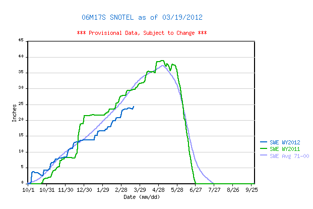
Wolf Creek Summit Snotel has reported virtually static SWE since the D4 event, March 6, until receiving several inches of new snow Sunday, March 18, in association with D5. This new snow containing D5 will rapidly settle and enable D5 to merge with D4. Solar energy absorbed by that merged dust will continue to accelerate the warming of the snowcover until becoming isothermal. At that time SWE losses would begin to accelerate, given that D5/D4 remains exposed at the snowpack surface.
Forecast
The National Weather Service expects sunny skies and unseasonably warm temperatures to return soon after the current storm clears (Tuesday, March 20). Under the combination of strong solar radiation and warm air temperatures later this week, settlement of new snow containing D5 will be very rapid and D5 will quickly merge with the D4 layer. Where snowpacks in this locale are already at or very near isothermal temperatures, solar energy absorbed by the emerging D4/D5 dust will begin and/or accelerate snowmelt rates and SWE losses. Where the snowpack retains cold content, energy absorbed by that D5/D4 dust will continue to accelerate warming of the snowcover. As always, the lowest elevation snowpacks (now generally isothermal) will most rapidly respond to radiative forcing.