 CODOS Update for Grand Mesa site:
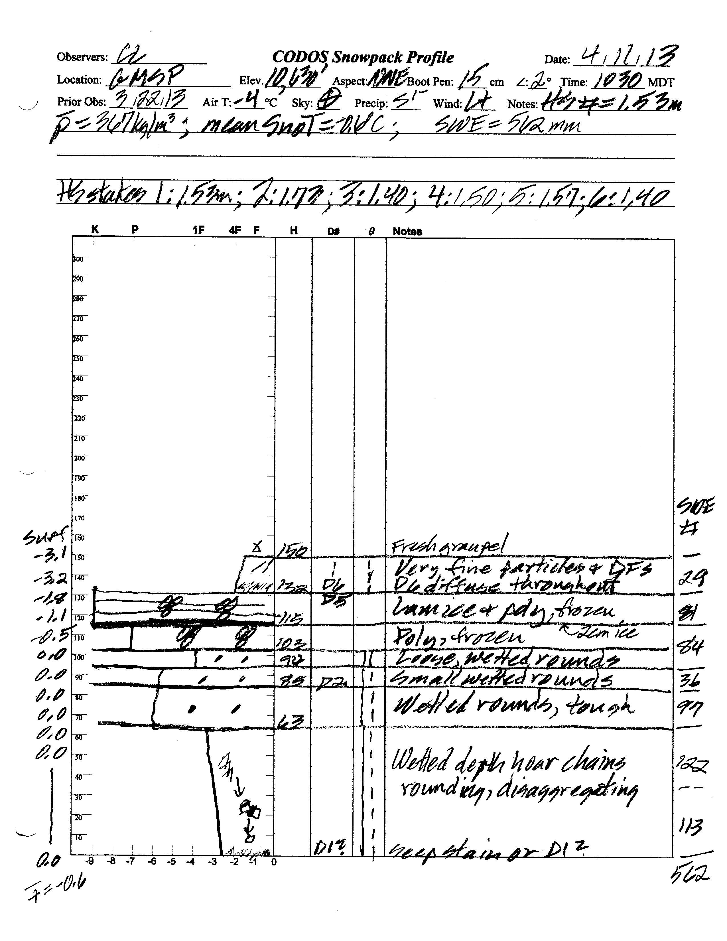
visited April 11, 2013
Summary | Snowpack | Melt Rate | Stream Flow | Forecast
Summary
Although dust-on-snow layer D6 (April 8) was not yet apparent at the snowpack surface during the April 11 site visit, D6 will significantly accelerate Grand Mesa WY 2013 snowmelt rates as and when it does emerge. As a result of dust enhanced surface snowmelt in late March and early April, the snowpack at the CODOS Grand Mesa site was virtually isothermal on April 11, 2013. SWE has increased somewhat since our prior visit, but some SWE loss has occurred with free water reaching the base of the snowpack and soil. Winter storms in March and early April have resulted in the Grand Mesa CODOS site retaining more snowcover and SWE than was present on April 4, 2012. (A new winter storm is in progress on the Grand Mesa as of this writing, Sunday, April 14.)
SnowPack Discussion
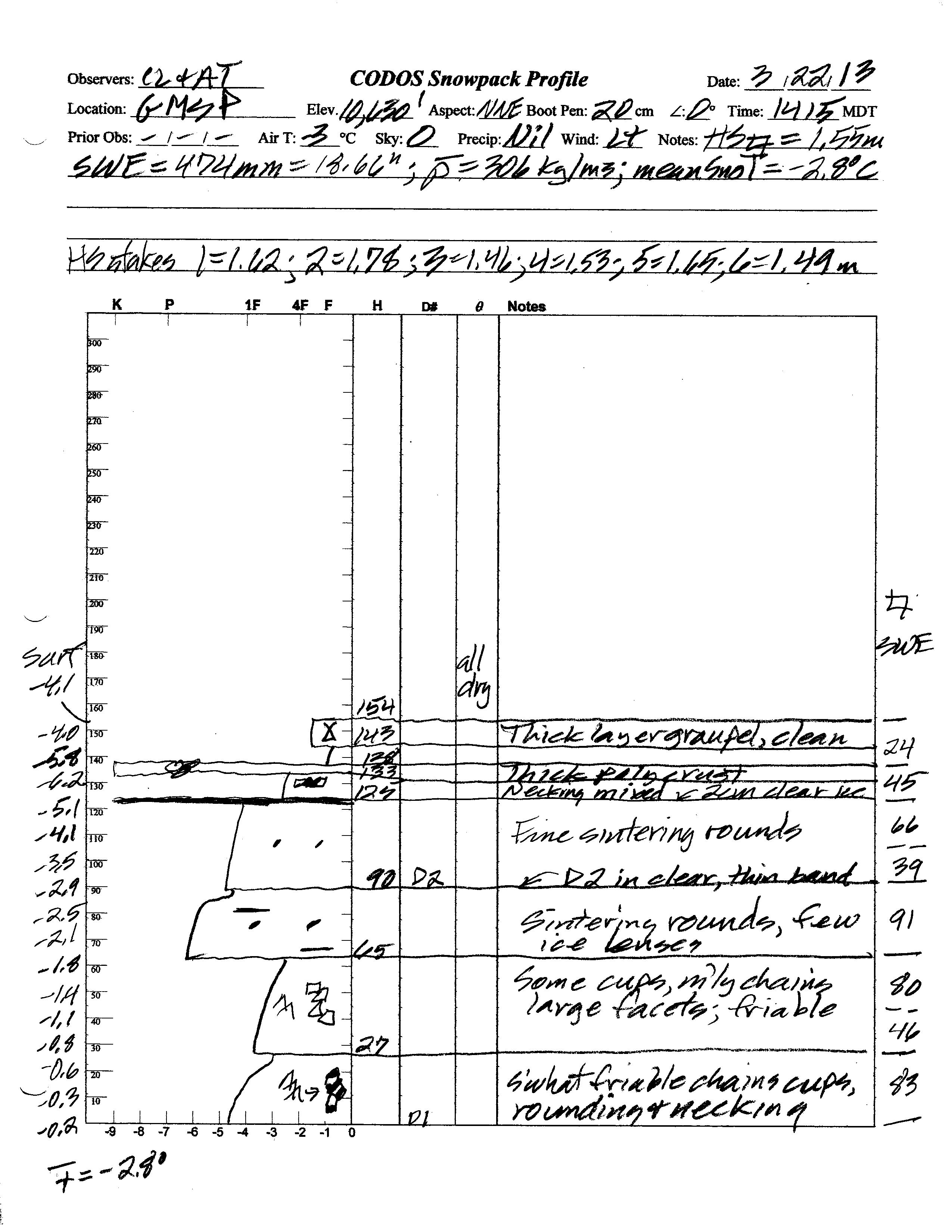
Total snow depth in the April 11, 2013 Grand Mesa (GMSP) snow profile was 59”, just 2” less than observed at the site on March 22, 2013. Total SWE on April 11 was 22.1” and mean density of the snowpack was 367 kg/m3 (36.7% water content) versus 18.7” SWE and 306 kg/m3 mean density (30.6% water content) on March 22, 2013.
The top 7” of the snowpack on April 11, 2013 consisted of snow containing dust-on-snow event D6-WY2013 (April 8). Underneath that layer a thick band of re-frozen melt-freeze polycrystal layers, interspersed with layers of ice, contained the D5 dust event that was underway during our March 22 site visit. Dust layer D2 is still clearly visible mid-pack. Most of the snowpack was either moist or near-wet and all layers showed evidence of recent wetting, by percolation of free water from the surface. Aside from cool snow at the surface, two-thirds of the snowpack was isothermal at 0.0° C, so mean snowpack temperature in this profile of -0.6° C, as compared to -2.8° C on March 22, 2013.
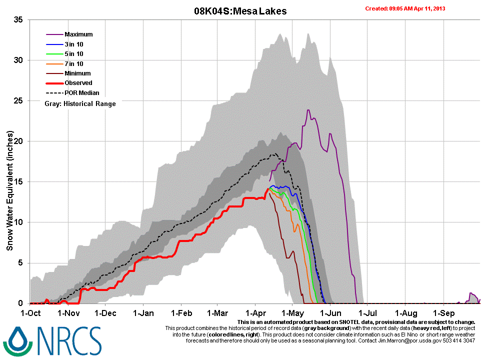
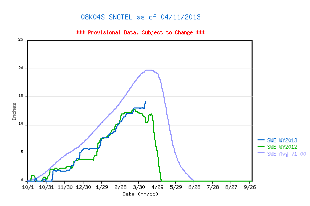
April 11, 2013 Mesa Lakes Snotel data places current SWE near the top of the lower quartile of SWE values for the period of record. Although higher than the same-date value recorded in WY 2012, SWE is still well below the 1971-2000 mean for that Snotel site.
| March 22nd Pit Profile | April 11th Pit Profile | |
 |
 |
|
 |
 |
|
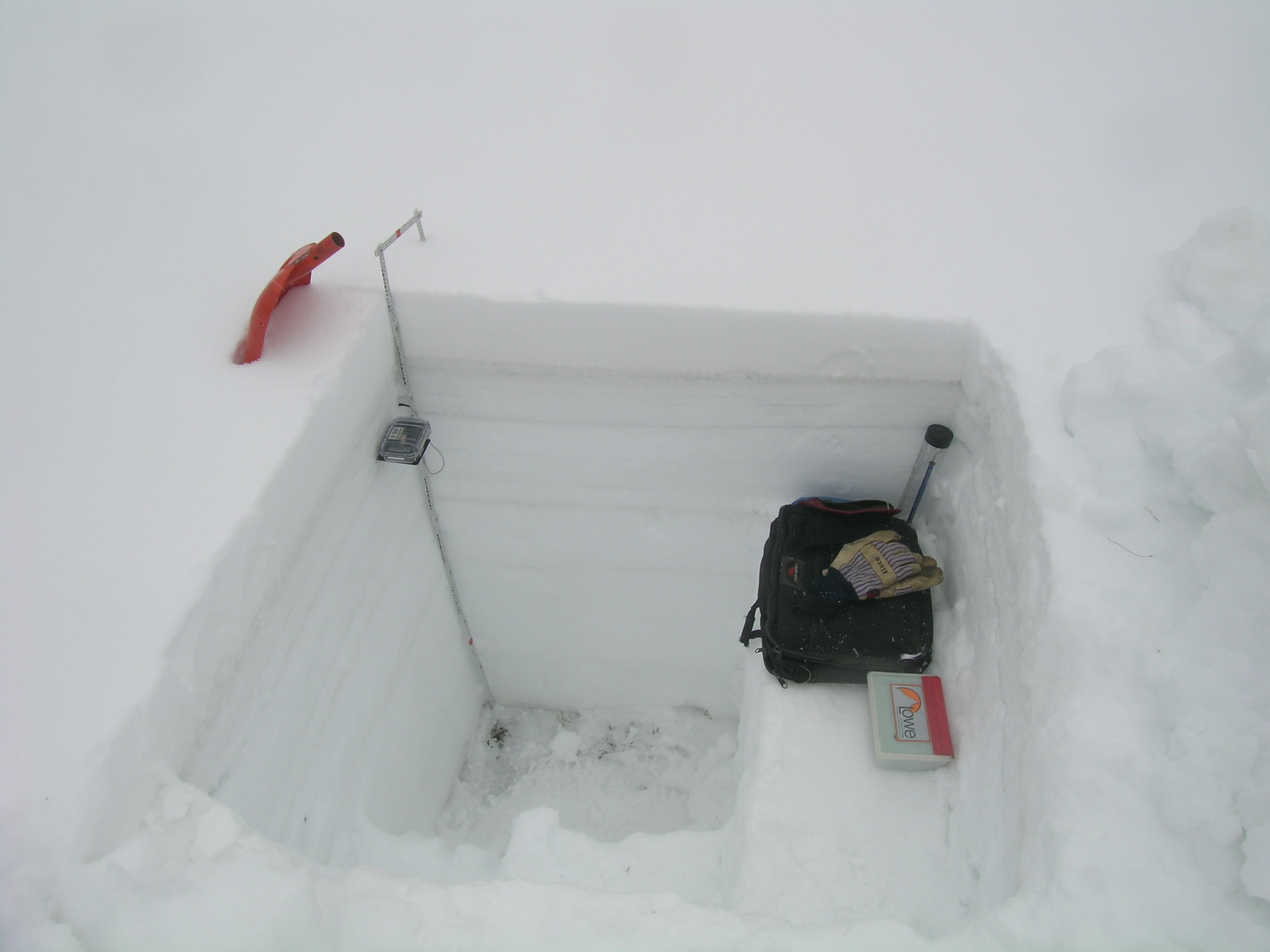
| March 22nd Pit Photo |
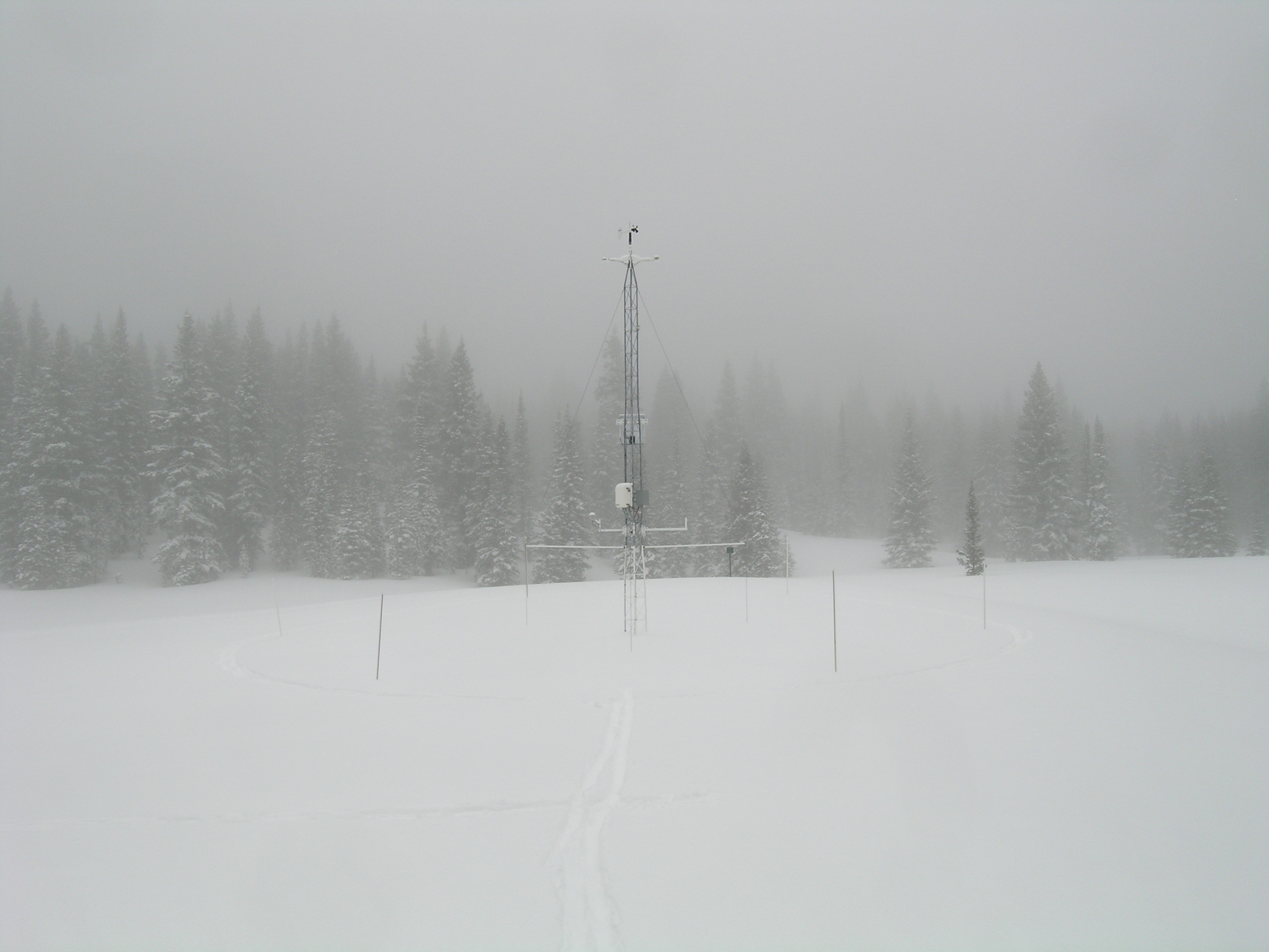
Clouds had just descended onto the Grand Mesa upon arrival at the study site on April 11, 2013, but winds were very light. |
|
 |
 |
|
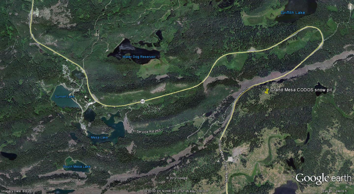
Grand Mesa CODOS snow profiles are performed within a few yards of the Jet Propulsion Lab’s Grand Mesa Study Plot tower. |
D6 dust was found in the new snow layer that fell onto the D5 layer at the top of the thick band of melt-freeze polycrystals and ice shown in the April 11 profile and seen above the thermometer case in these photos, next to the ruler in the pit corner. Dust layer D2 was still clearly seen, mid-pack, as a dark band a few inches below the thermometer case. |
Melt Rate
The Mesa Lakes Snotel site continues to accumulate SWE and reports no significant losses of SWE, to-date. However, the April 11 snow profile at the Grand Mesa CODOS site found evidence that episodes of surface snowmelt, enhanced by dust event D5, had occurred and that free water had percolated through the entire snow cover and reached the soil. Dust layer D6 had not yet emerged or received enough radiation through the overlying snowcover to produce snowmelt in the snow containing D6. However, data from the Jet Propulsion Lab instrumentation at the Grand Mesa Study Plot suggest that D6 began to emerge and marginally reduce snow albedo in the two days following the site visit. As of this writing (April 14), Grand Mesa is receiving another layer of fresh snow that will, once again, restore a higher snow albedo and delay the inevitable full emergence and impact of dust layer D6 on snow albedo. As and when D6 does more-or-less fully emerge, and remain exposed for some days, snowmelt rates will dramatically accelerate on the Grand Mesa. SWE loss rates may match those observed in spring 2009 and snowpack ablation to “snow all gone” (SAG) will be significantly advanced, perhaps matching the early dates of SAG in seen in spring 2012, given the similar snowpack this season.
Stream Flow
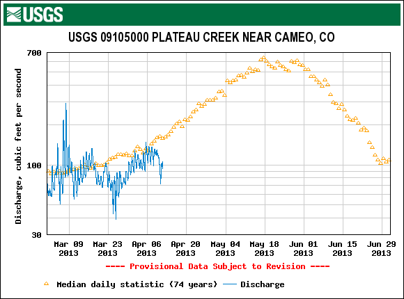
Streamflow data from the USGS Plateau Creek near Cameo gauge show an early March surge in flows, likely from low elevation snowmelt, and a more recent uptick in late March and early April flows. The more recent surge in snowmelt was likely enhanced by dust event D5 (March 21-22), given the intense melt-freeze evidence in the Grand Mesa snow profile on April 11. This graph, captured on April 11, does not yet indicate the influence of event D6 (April 8), since D6 has yet to significantly emerge.
Forecast
As of Sunday, April 14, The National Weather Service expects unsettled weather to continue through Wednesday, April 17, with snow levels dropping to higher valleys. A significant weather system is expected to arrive Monday with strong winds (Red Flag Warnings posted for southwestern valleys) but snowfall may favor the central and northern mountains, including Grand Mesa. Partly sunny weather may return to the Grand Mesa by Thursday, but no prolonged drying is anticipated at this time as the weather remains “progressive”, with an another potential system shaping up for next Saturday.
Given additional new snowfall during the week of April 14-20, and without further dust-on-snow, the emergence of dust layer D6 will continue to aspect driven, with earliest exposure at lowest snow-covered margins of the Mesa flanks, but quickly followed by the level Mesa proper. Even on mostly cloudy days early in the week, sufficient radiation may reach the snowpack to penetrate the new snow layer, reaching the D6 layer below and accelerating the ablation of the new snow. Regional streamflow data for Grand Mesa watersheds may reflect the onset of D6-enhanced snowmelt rates by the end of the week, but the full effects of D6 may be delayed until the following week, given drier and sunnier weather then.