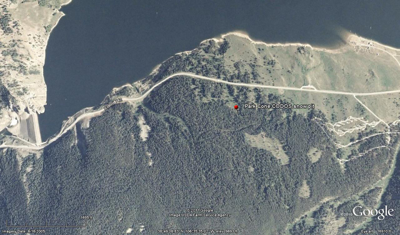
 CODOS Update for Park Cone site:
visited April 11, 2013
Summary | Snowpack | Melt Rate | Stream Flow | Forecast
Summary
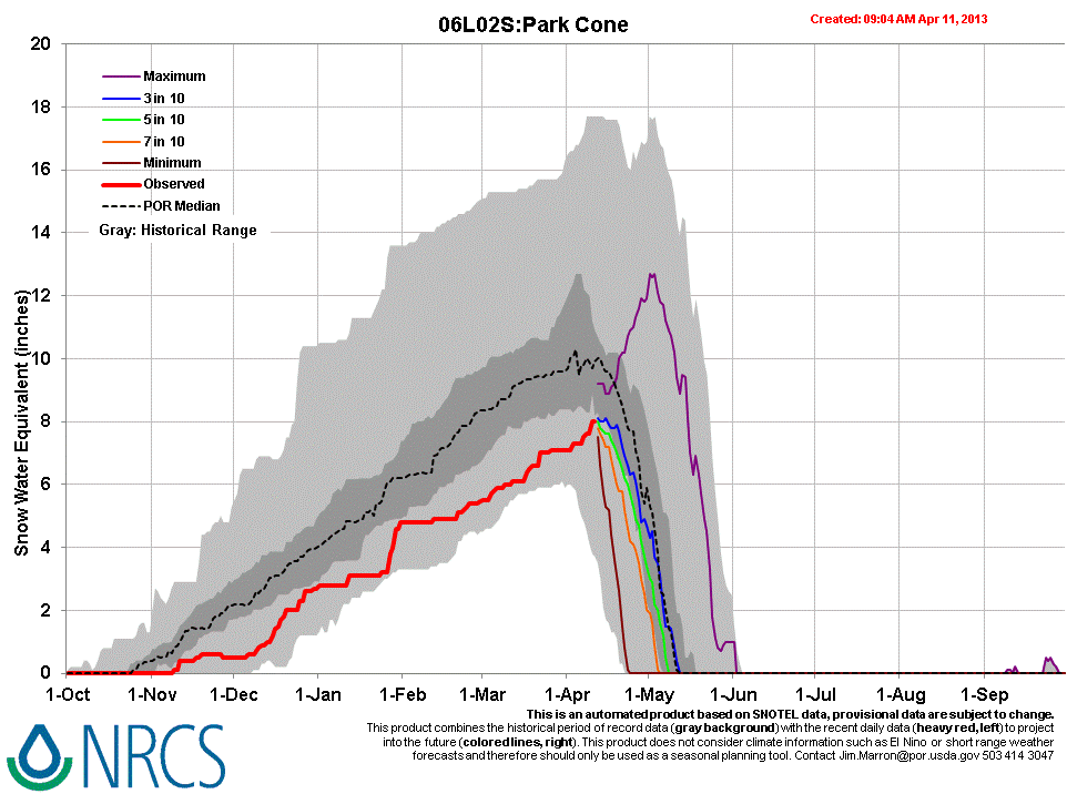
Dust-in-snow layer D6 (April 8), likely merged with D5 (March 21-22), was found in the snowpack surface at the Park Cone CODOS site on April 11, 2013, substantially reducing snowcover albedo. Active snowmelt runoff was underway in the fully isothermal and wet snowpack. Snowpack SWE at the CODOS site decreased by only 0.6” since our prior March 18, 2013 visit but was still double that observed a year earlier, on April 9, 2012. (Another winter storm immediately followed this site visit and yet another significant storm is predicted as of this writing, Monday, April 15.)
SnowPack Discussion
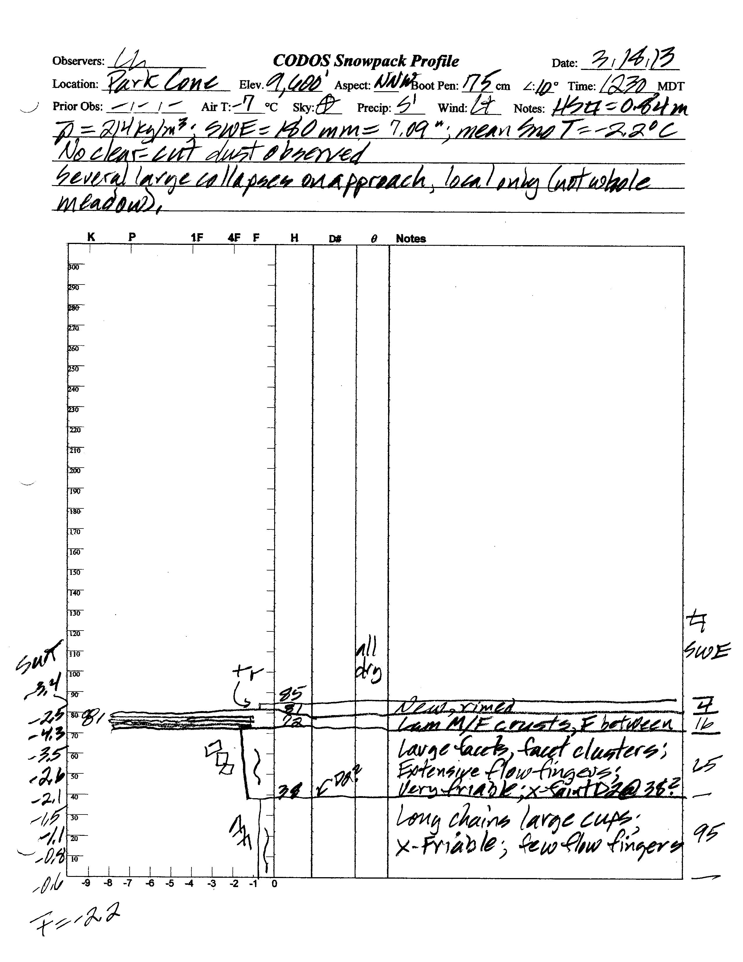
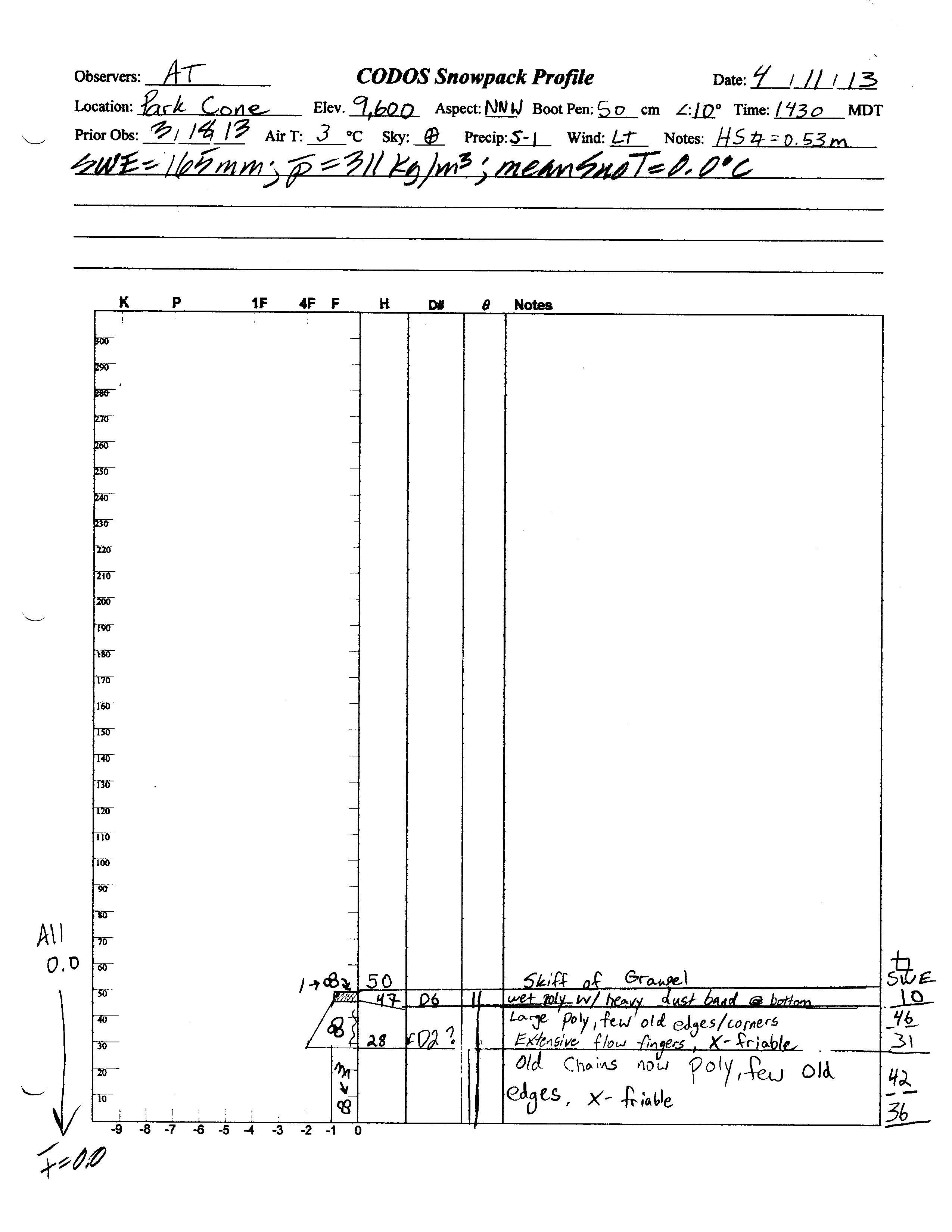
Snowcover at the Park Cone CODOS site was fully isothermal and undergoing active snowmelt and runoff during the April 11, 2013 site visit. Total snow depth in the snow profile was only 20”, almost 14” less than observed at the site on March 18, 2013. Total SWE on April 13, 2013 was also reduced to 8.6”, down 4” of SWE since March 18, 2013, and mean density was 311 kg/m3 (31.1% water content), up from 214 kg/m3. In contrast, this site was on the verge of “snow all gone” (SAG) by April 11, 2012, with just 9” of snow on the ground.
Dust layer D6 (April 8) had likely merged with layer D5 (March 21-22), which closely followed the prior site visit. This dust band was just beneath the comparatively clean but wet snowpack surface, darkening the snowcover and reducing snow albedo. Inconclusive hints of dust layer D2 (February 8) were also observed. The basal layer in the snowpack was composed of wet, disintegrating chains of large depth hoar grains transforming into melt/freeze polycrystals. The snowpack was isothermal at 0.0° C throughout.
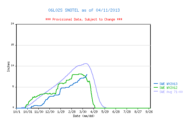
April 11, 2013 Park Cone Snotel data reports current SWE having approached the top of the lower quartile of SWE values for the period of record, and still rising. Thanks to March and April 2013 precipitation, this season’s SWE has finally matched the Peak SWE of spring 2012, but still remains well below the 1971-2000 mean.
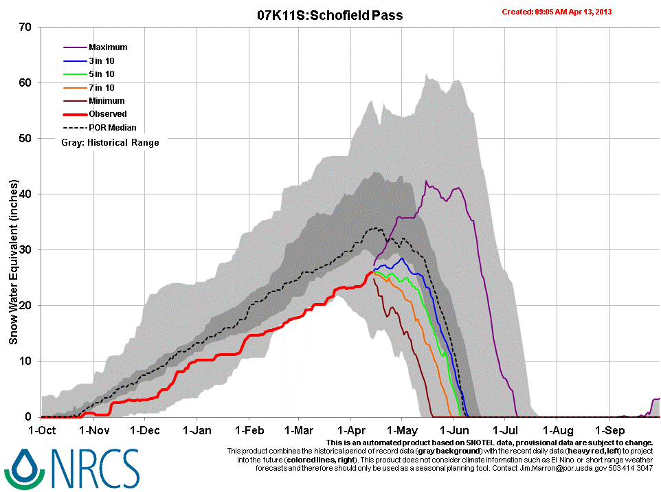
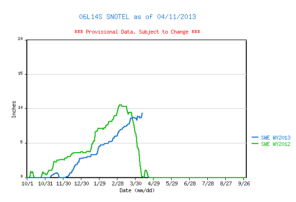
Higher in the Taylor Fork watershed, the Upper Taylor Snotel reported 9.2” of SWE on April 11, 2013, 1.2” more SWE than at Park Cone that day. Farther north and west, the Schofield Pass Snotel reported 25.6” of SWE on April 11, still within the lower quartile of values for the period or record.
Elsewhere in the Gunnison River watershed, the presence of significant D6 dust was confirmed at McClure Pass, and even stronger D6 was found at Spring Creek Pass. We infer from those observations that D6 is present at moderate or strong levels in the snowcover throughout the Gunnison and Uncompahgre Basins.| March 18th Pit Profile | April 11th Pit Profile | |
 |
 |
 |
 |
|
| March 18th Pit Photo |
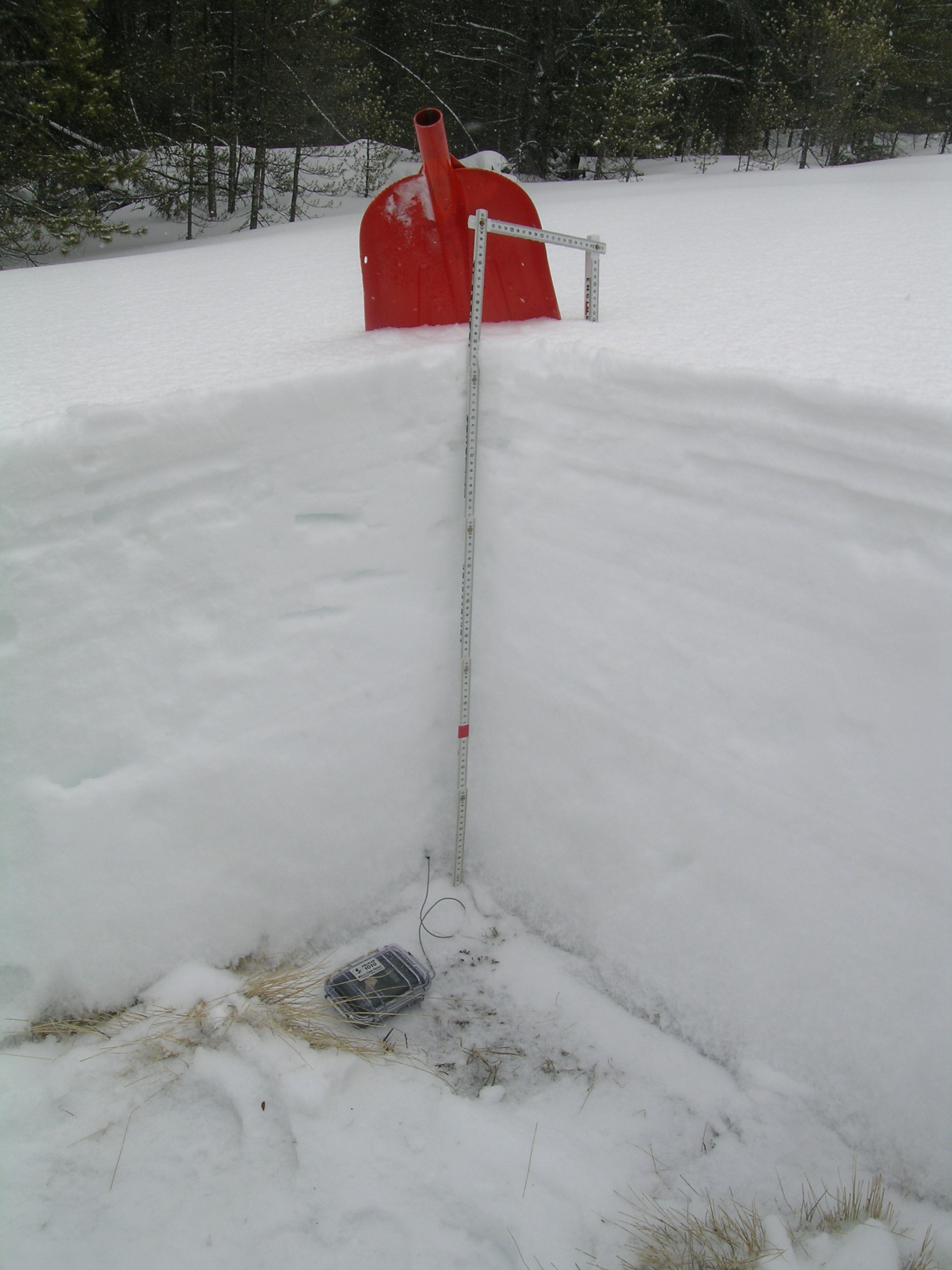
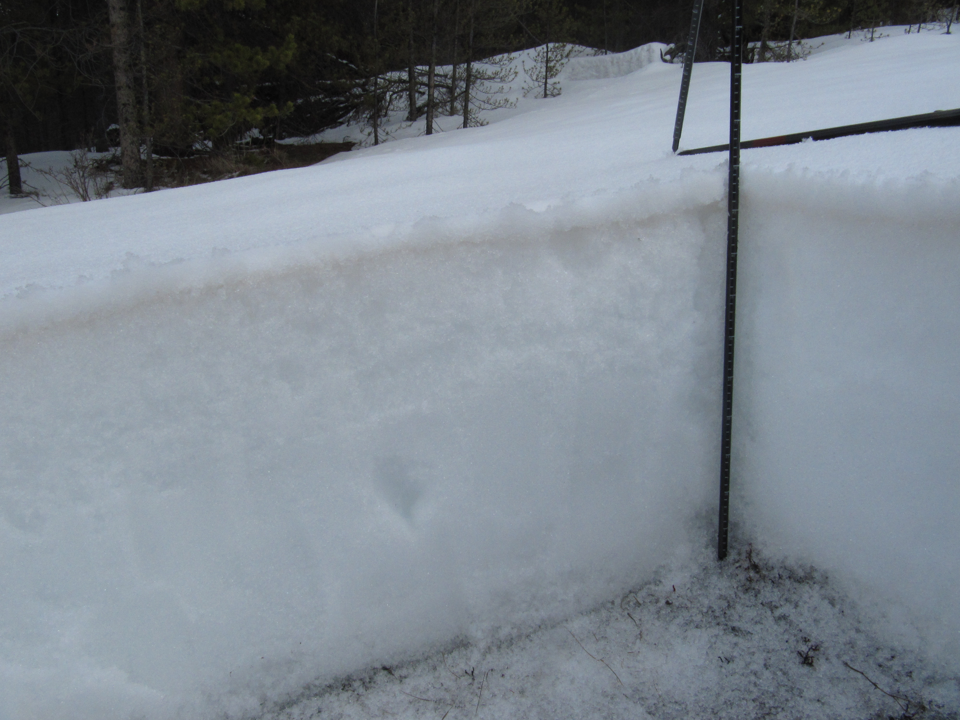
The April 11, 2013 Park Cone snowpit showing the merged D6/D5 dust layer just below cleaner new snow at the surface. The Park Cone Snotel site is less than 50 yards away, in the forest seen in the background. |
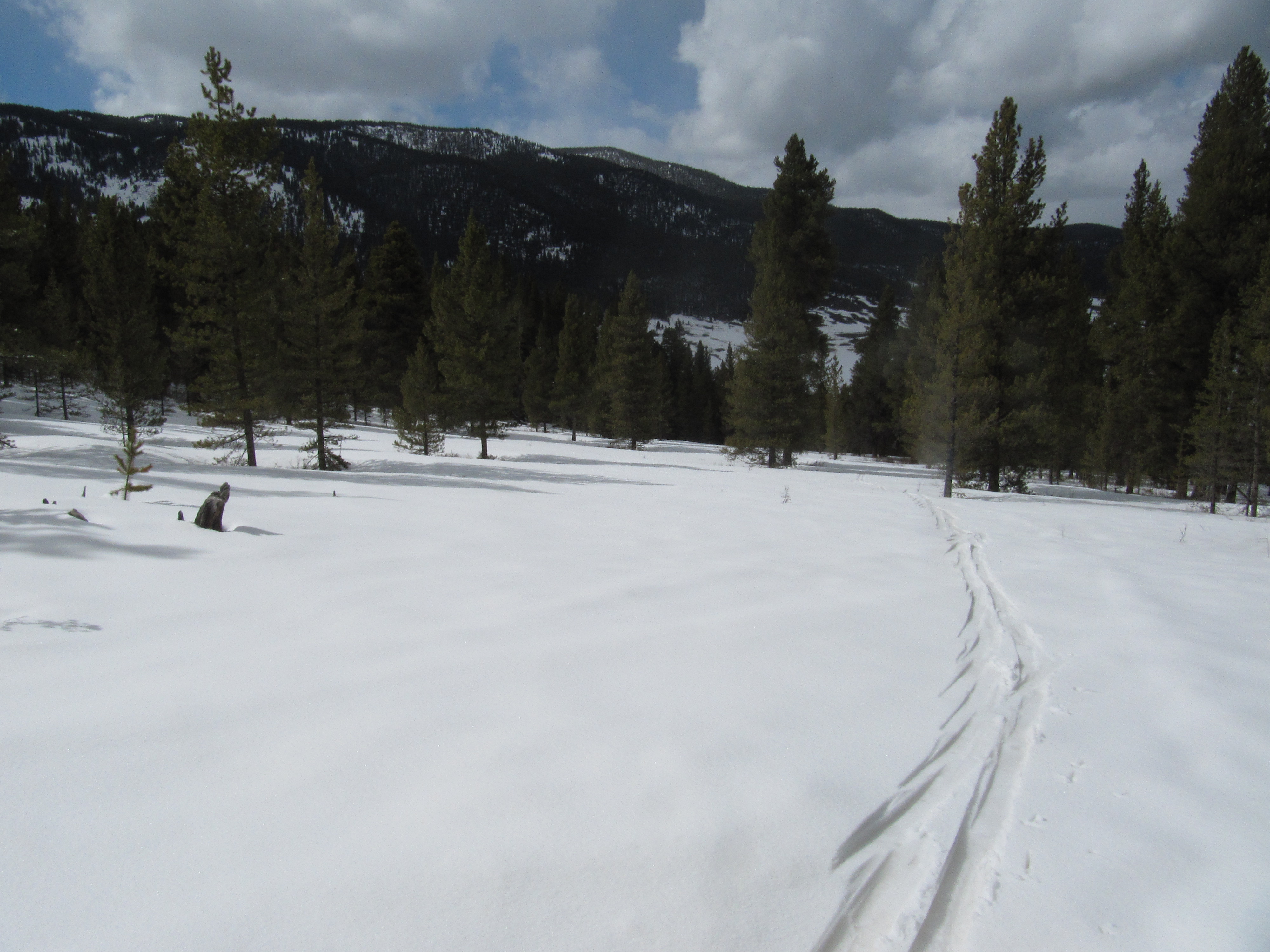 |
Compression of the overlying cleaner snow clearly revealed dust layer D6/D5 in ski tracks on the approach to the Park Cone CODOS site. |
Melt Rate
The comparatively shady Park Cone Snotel site has reported steadily increasing or ‘flat’ SWE values since mid-March, with no significant declines in SWE. In contrast, our CODOS site has lost SWE and the snowpack there is discharging snowmelt (some or much of which may have been retained by the on-site soils). Since the site visit, the Park Cone locale has received modest amounts of fresh snow that will somewhat reduce the near-term impact of dust layers D6/D5 on snow albedo. As and when merged layers D6/D5 do more-or-less fully emerge, and remain exposed for some days, snowmelt rates will accelerate rapidly in the Taylor River watershed and could result in SWE loss rates matching the 1” losses per day observed in spring 2012, even absent additional dust this spring. Ablation of this season’s sub-par Park Cone snowcover to “snow all gone” (SAG) will also be significantly advanced by merged layers D6/D5, as and when those (and/or additional dust layers) remain exposed for sustained periods.

Stream Flow
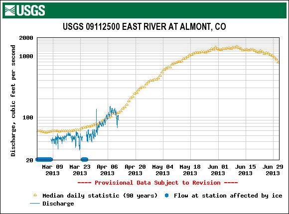
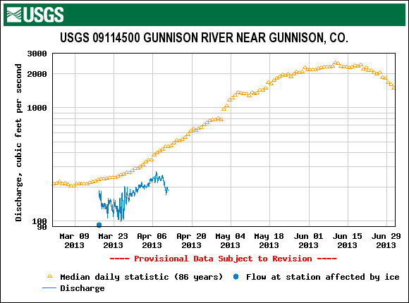
Streamflow data from the USGS East River Near Almont and Gunnison River at Gunnison gauges show some surging in late March and early April, to near-average levels, likely enhanced by the impact of dust layer D5 on lower elevation snowcover. Dust layer D6 was observed on April 11 in the scant snowcover remaining in the lower Gunnison valley, at Cerro and Blue Summits. Subsequent to those minor surges, flows declined as the new snow and winter weather delivering dust layer D6 restored a higher albedo to the snowcover in those headwaters and halted that snowmelt episode. The influence of dust layer D6 is not yet seen, in these graphs (collected April 11), since D6 was still somewhat shielded from radiation by new snow. (Since then, the gauges report a slight uptick on/about April 15/16). Streamflows on the Taylor River and main stem and tributaries of the Gunnison River will surge substantially as and when dust layers D5/D6, and eventually perhaps D2, emerge and remain at the surface for extended periods. Snowmelt runoff duration may be shortened, however, as the sub-par snowpack melts at a substantially increased rate.
Forecast
As of Monday, April 15, the National Weather Service expects unsettled weather to continue through most of the week of April 14-20. A significant weather system is expected to arrive today (Monday, April 15) with strong S and SW’ly winds. A Winter Storm Watch anticipates 8-14” of new snow, or more, in the Elk Mountains. Partly sunny weather may return to the Park Cone locale by Friday, but no prolonged drying is anticipated at this time as the weather remains “progressive”, with an another potential system shaping up for next Saturday.
Given additional new snowfall during the week of April 14-20, and without further dust-on-snow, the emergence of dust layers D6/D5 (and D2 where present) will be aspect and elevation driven, with earliest exposure at lowest snow-covered elevations, perhaps quickly followed at Pass elevations. Wind stripping may also reveal patches of dust-in-snow in exposed, alpine locations. Even on mostly cloudy days, sufficient radiation may reach the snowpack to penetrate new snow and reaching the D6/D5 layer below and accelerating the ablation of the new snow received this week.