 CODOS Update for Wolf Creek Pass site:
visited April 12, 2013
Summary | Snowpack | Melt Rate | Stream Flow | Forecast
Summary
Although dust-on-snow layer D6 (April 8) was not yet apparent at the snowpack surface during the April 11 site visit, D6 and other layers will significantly accelerate Wolf Creek Pass WY 2013 snowmelt rates as and when those dust layers does emerge and merge. As a result of dust enhanced surface snowmelt in late March and early April, the snowpack at the Wolf Creek Pass CODOS site was virtually isothermal on April 12, 2013. SWE has increased somewhat since our prior visit, but some SWE loss has occurred with free water reaching the base of the snowpack and soil. Winter storms in March and early April have resulted in the Wolf Creek Pass CODOS site retaining more snowcover and SWE than was present on April 4, 2012. (A new winter storm is in progress on the Wolf Creek Pass as of this writing, Sunday, April 14.)
SnowPack Discussion
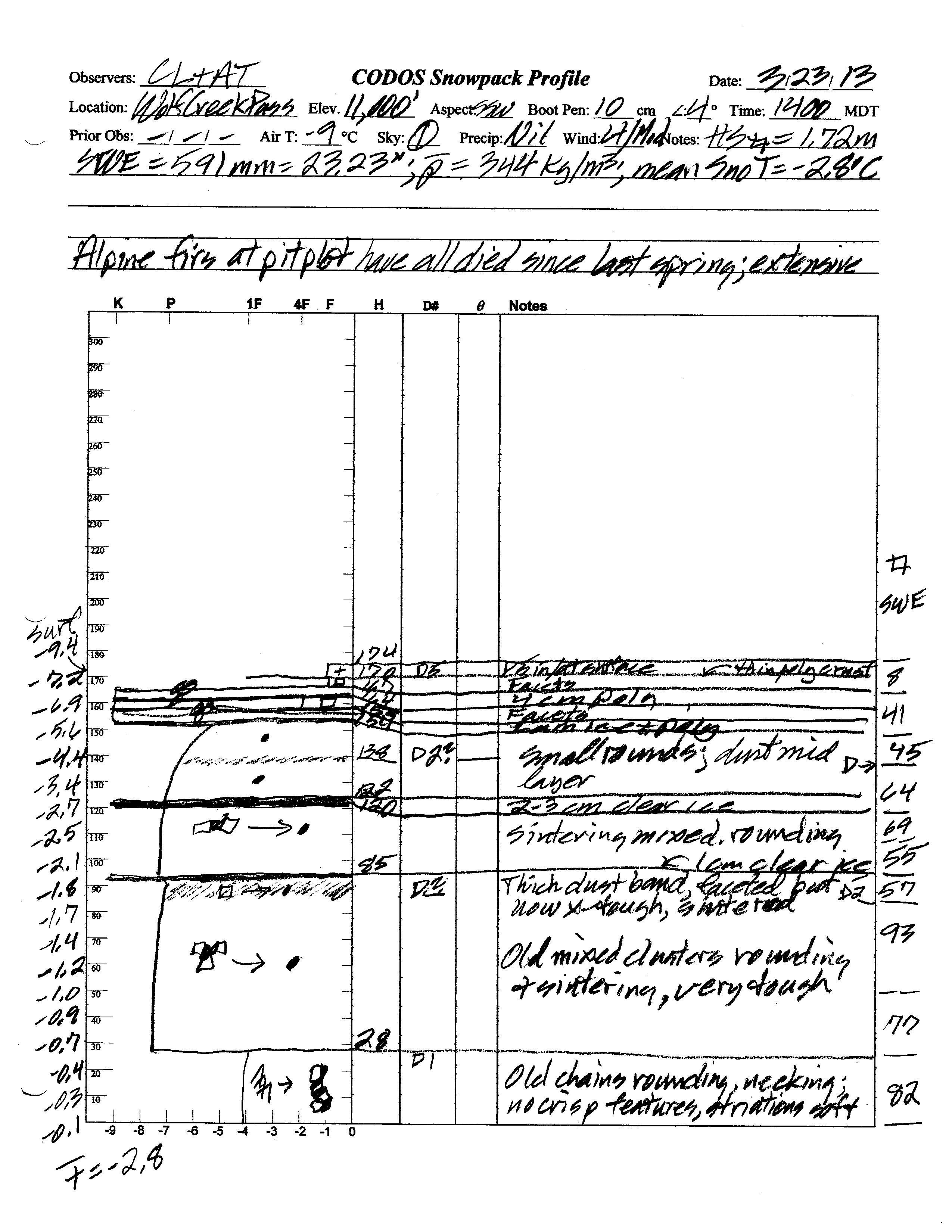
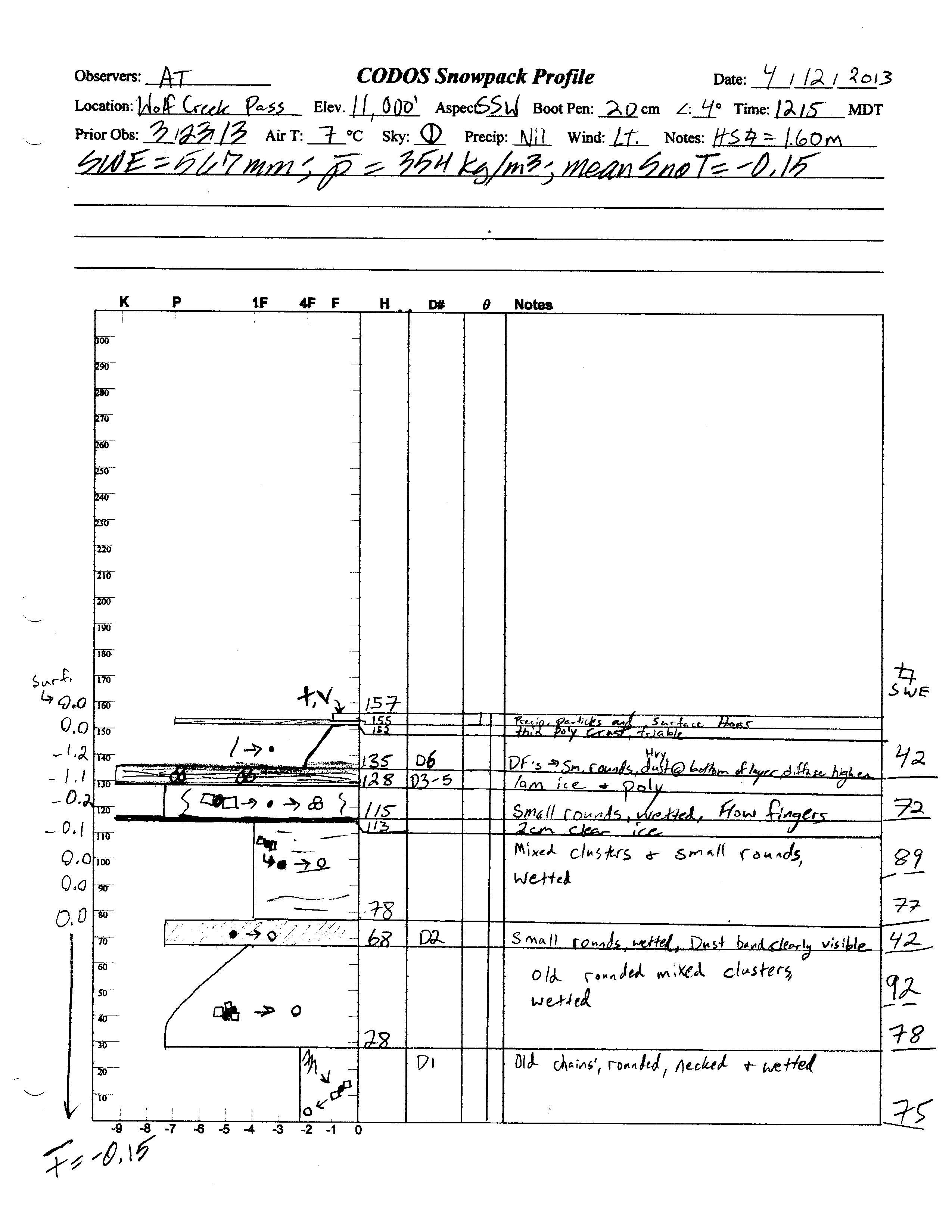
Total snow depth in the April 12, 2013 Wolf Creek Pass CODOS snow profile was 59”, just 2” less than observed at the site on March 23, 2013. Total SWE on April 11 was 22.1” and mean density of the snowpack was 367 kg/m3 (36.7% water content) versus 18.7” SWE and 306 kg/m3(30.6% water content) mean density on March 23, 2013. March and April 2013 snowfalls have resulted in the Wolf Creek Pass CODOS site retaining 24” more snowcover containing 9.7” more SWE than was observed on April 9, 2012. Additional snowfalls have occurred since the visit, and are expected in the coming week.
The top 9” of the snowpack on April 12, 2013 consisted of snow containing dust-on-snow event D6-WY2013 (April 8). Underneath that layer a thick band of re-frozen melt-freeze polycrystal layers, interspersed with layers of ice, contained merged D5/D4/D3 dust events and dust layer D2 was still clearly visible mid-pack. The snowpack was moist throughout and all layers showed evidence of recent wetting, be percolation of free water from the surface. Aside from cool snow at the surface, the snowpack was effectively isothermal at a mean snowpack temperature of -0.15° C, as compared to -2.8° C on March 23, 2013.
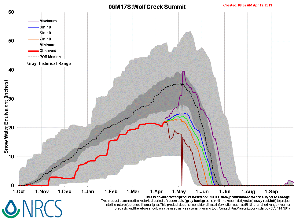
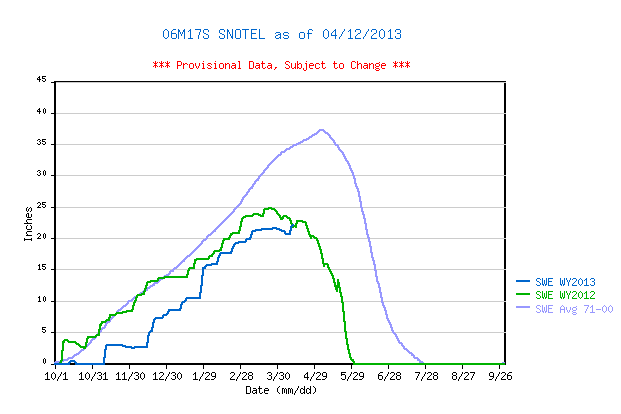
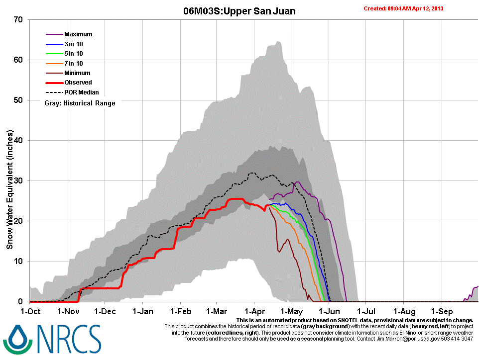
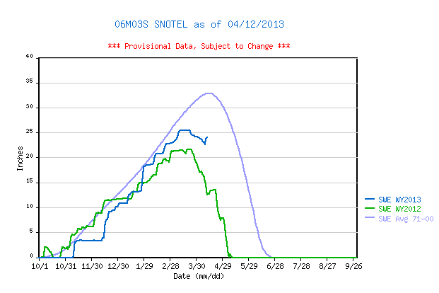
April 12, 2013 Wolf Creek Summit Snotel data places current SWE within the lower quartile of SWE values for the period of record and still gaining. Farther west, the Upper San Juan Snotel also did approach the period of record median during February but has since slipped back within the lower quartile and shows recent declines in SWE, likely enhanced by event D5. Although the Wolf Creek Summit snowpack has yet to match peak SWE of 2012, the Upper San Juan did exceed the 2012 peak SWE but is still well below the 1971-2000 mean for that Snotel site.
 |
 |
|
| March 23rd Pit Profile | April 12th Pit Profile |
 |
 |
|
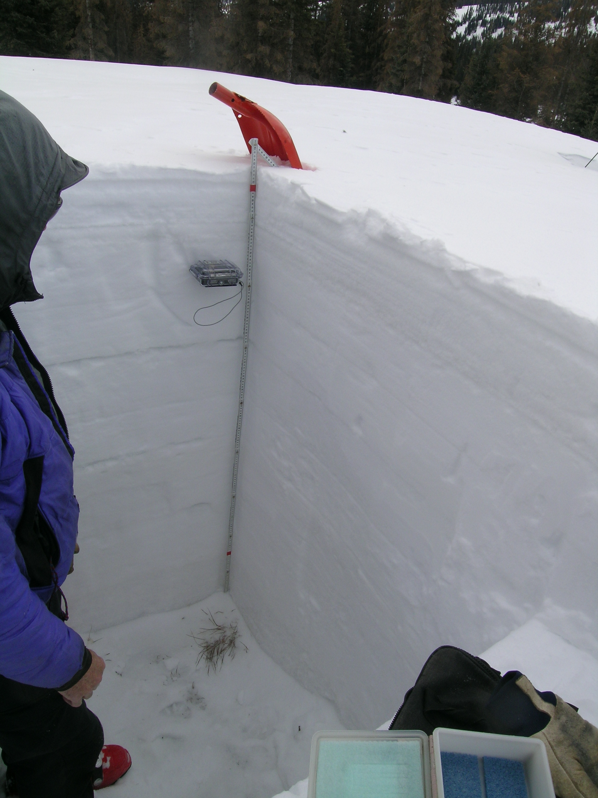
| March 23rd Pit Photo |
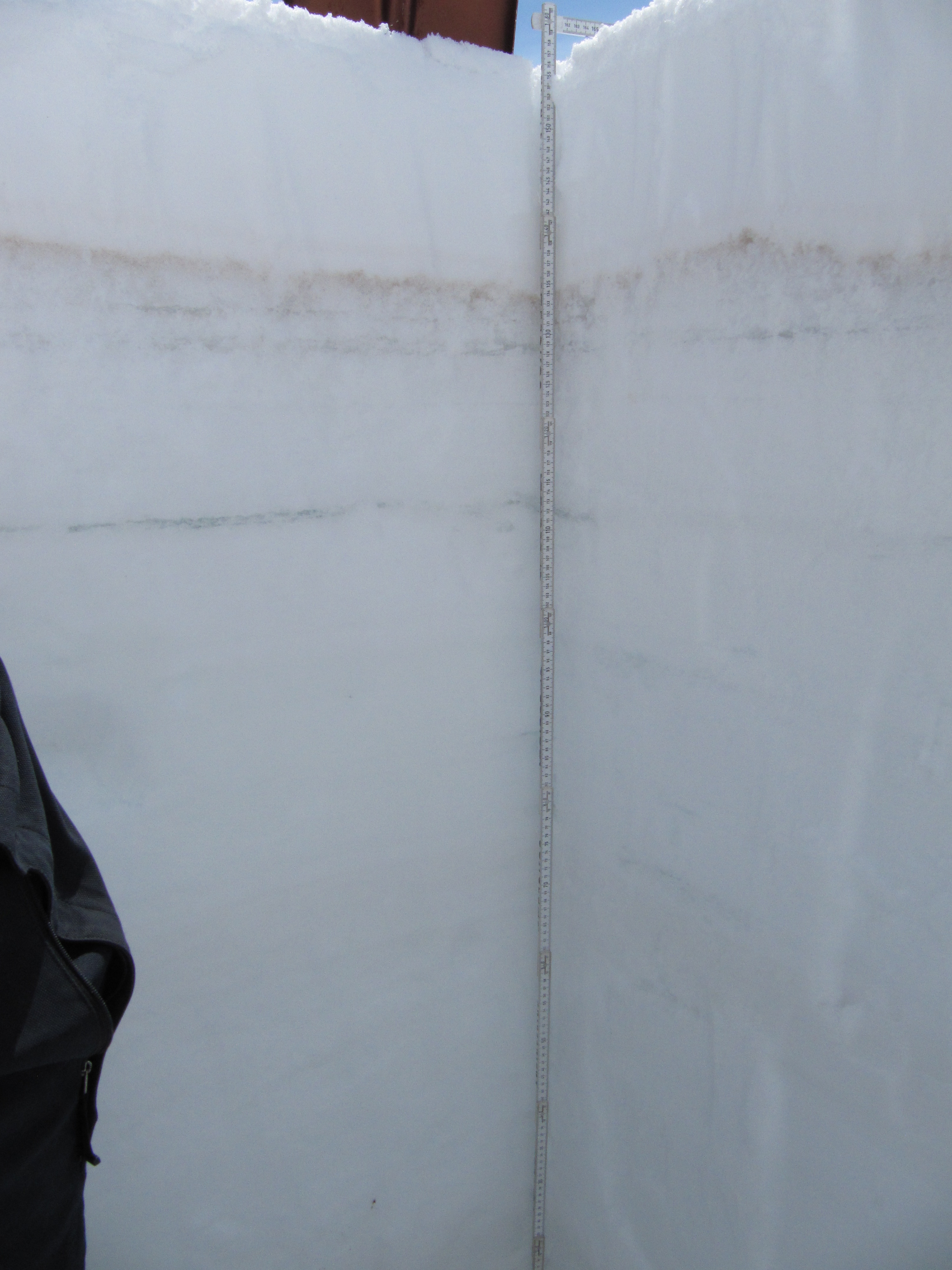
The April 12, 2013 Wolf Creek Pass snowpit showing the very strong D6 dust layer below cleaner new snow at the surface. Dust layers D5/4/3 are contained in the icy layer seen just below D6. |
|
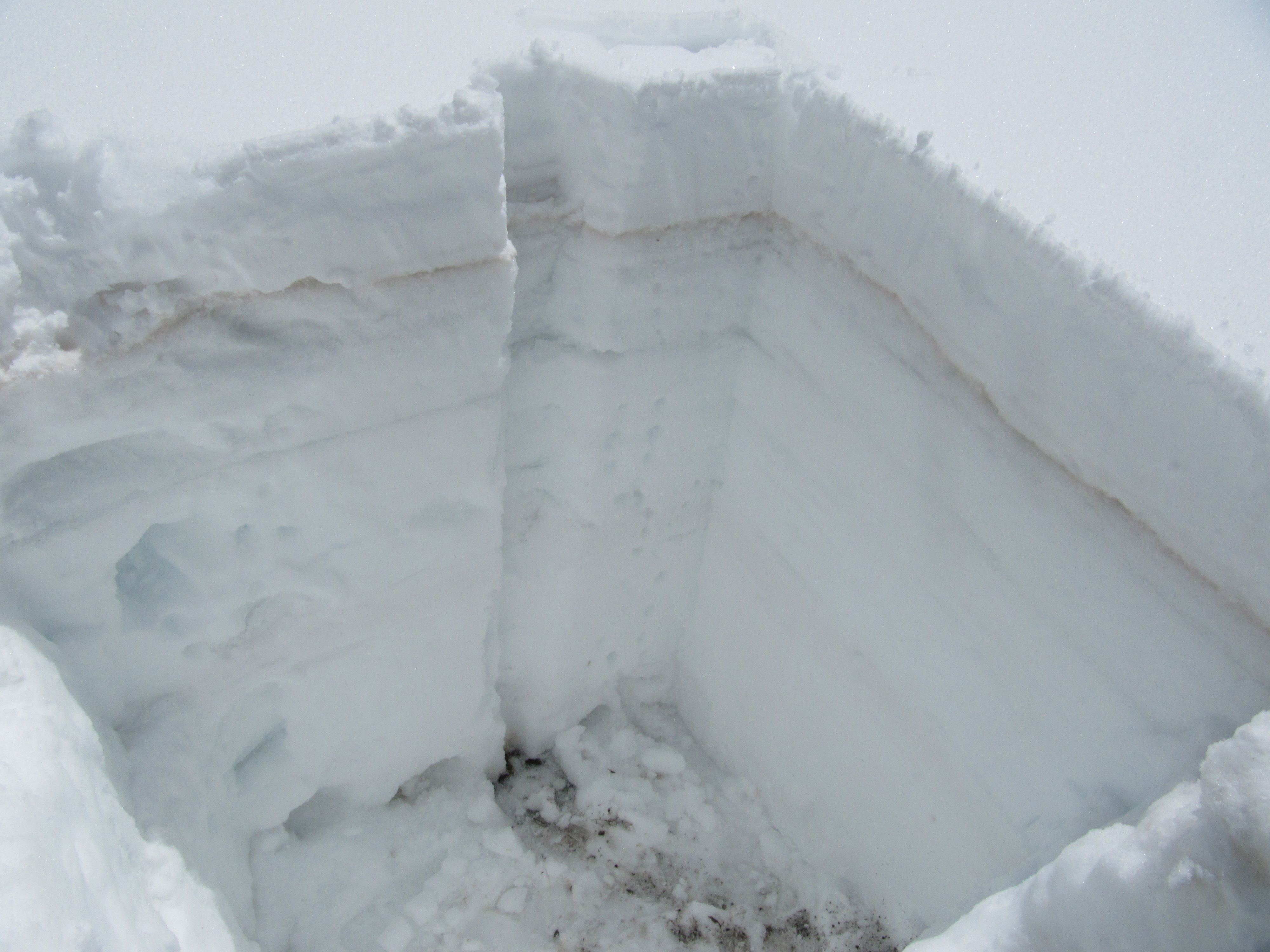 D6 intensity nearly matches the magnitude of deposition at Senator Beck Basin, located 58 miles to the northwest. |
||
Melt Rate
The well-shaded Wolf Creek Summit Snotel site continues to accumulate SWE and reports no significant losses of SWE, to-date. In contrast, the much sunnier Upper San Juan Snotel site lost some 5” of SWE in late March and early April. The Wolf Creek Pass CODOS site also enjoys full exposure to sunlight. The April 12 snow profile at the Wolf Creek Pass CODOS site found clear evidence of surface snowmelt, enhanced by dust event D5, and signs that free water had percolated through the entire snow cover and reached the soil. Dust layer D6 had not yet emerged or received enough radiation through the overlying snowcover to produce snowmelt in the snow containing D6. Since the April 12 site visit Wolf Creek Pass has received another layer of fresh snow that at least partially restored a higher snow albedo and will delay the inevitable full emergence and impact of dust layer D6 and the underlying dust layers on snow albedo. As and when D6 does emerge and merge with D5/D4/D3 just below, and then remain exposed for some days, snowmelt rates will dramatically accelerate on both sides of Wolf Creek Pass, producing runoff surging in those San Juan and Rio Grande River tributaries. SWE loss rates may match those observed in spring 2010, at up to 2” loss per day (maximum 5-day moving average) and snowpack ablation to “snow all gone” (SAG) will be significantly advanced, perhaps even matching the early dates of SAG seen in spring 2012, given the similar snowpack this season.
Stream Flow
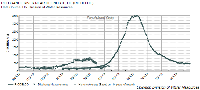
Streamflow data from the Colorado Division of Water Resources Rio Grande at Del Norte gauge do not yet present clear evidence of dust-enhanced snowmelt runoff, to-date, whether from event D5 or D6. (A new dust event verified at Senator Beck Basin on April 14, event D7, is certain to have also been deposited in the Rio Grande watershed). However, we are confident that flows will surge substantially as and when dust layers D6/D6/D4/D3, and eventually D2, emerge and remain at the surface for extended periods. Snowmelt runoff duration may then be substantially shortened as the sub-par snowcover is consumed at an increased rate and cannot sustain what may be only briefly higher flows.
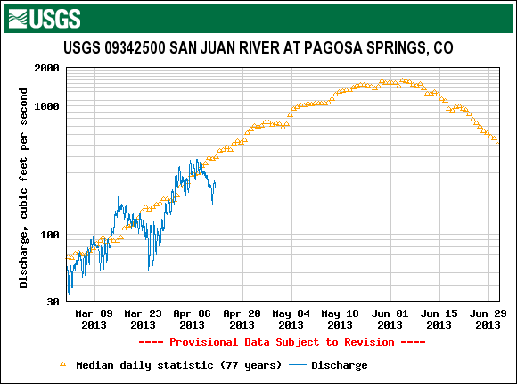
To the west, streamflow data from the USGS San Juan River at Pagosa Springs gauge do show surges in flows in March and early April, probably driven in large part by low elevation snowmelt. The more recent surge in snowmelt was likely enhanced by dust event D5 (March 21-22), given the intense melt-freeze evidence in the Wolf Creek Pass CODOS snow profile on April 12. This graph, captured on April 12, does not yet indicate the influence of event D6 (April 8), since D6 has yet to significantly emerge.
Forecast
As of Monday, April 15, the National Weather Service expects unsettled weather to continue through most of the week of April 14-20. A significant weather system is expected to arrive today (Monday, April 15) with strong S and SW’ly winds. (We have reports of yet another dust storm in progress in Durango, likely dust-on-snow event D8). A Winter Storm Watch has been issued for up to 12” of new snow, or more, at Slumgullion Pass but lesser amounts of snow are expected near Wolf Creek Pass, perhaps including rain. Partly sunny weather may return to the San Juan Mountains by Thursday, but no prolonged drying is anticipated at this time as the weather remains “progressive”, with an another potential system shaping up for next Saturday, primarily affecting the northern mountains.
Given additional new snowfall during the week of April 14-20, and without further dust-on-snow, the emergence of dust layers D6/D5/D4/D3 will be aspect and elevation driven, with earliest exposure at lowest snow-covered elevations, perhaps quickly followed at Pass elevations. Wind stripping may also reveal patches of dust-in-snow in exposed, alpine locations. Even on mostly cloudy days, sufficient radiation may reach the snowpack to penetrate new snow and reaching the D6/D5 layer below and accelerate the ablation of the new snow received this week.