Winter Storm Data 2014 – 2015
MOUNTAIN SYSTEM MONITORING: WINTER STORM DATA
This Precip and Storm Report Excel Workbook contains the current and past 13 seasons of CSAS winter storm data, including:
- Dates, times and duration of each winter storm event (2003-current)
- Change in the height of snow at both our alpine Senator Beck study plot and our subalpine Swamp Angel site.
- Peak gust data from our Putney site.
- Mean and maximum precipitation intensity during each storm
- Total new water accumulation in mm for each storm event.
- Summary data for each month of the season.
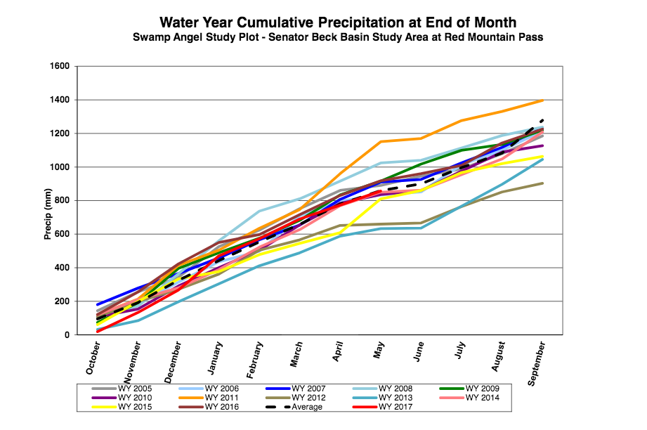
- Cumulative annual precipitation graph by month
See our Current Conditions for the latest hourly data. All times shown are in Mountain Standard Time (MST)
- CSAS Storm Definition >= 12 mm SWE with no break in precipitation >12 hours
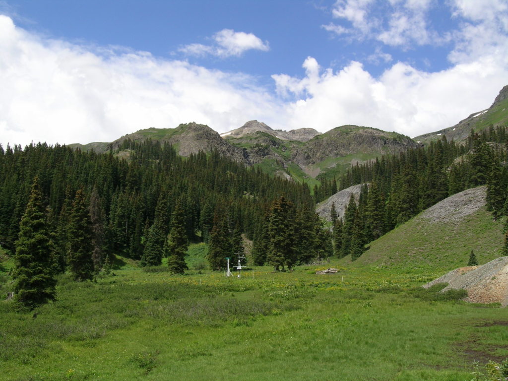
- SASP =Swamp Angel Study Plot(11,060′, in sub-alpine meadow)
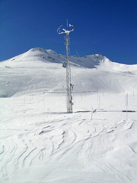
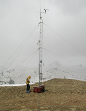
- SBSP =Senator Beck Study Plot(12,186′, on alpine bench)
- PTSP =Putney Study Plot(12,323′ alpine ridge ‘free air’ site)
2014-2015 WINTER STORM REPORTS:
Recent rain event, streamflow effects June Greetings from Silverton – Last Friday, Saturday, and Sunday June 5-7, we logged a total of 39 mm of precipitation (15 mm 6/5. 23 mm 6/6, and 1 mm 6/7) at the Swamp Angel Study Plot (SASP) at Senator Beck Basin. Given steadily rising streams in the days prior to this event, including our own Senator Beck Basin runoff, there was concern that additional snowmelt from rain-on-snow could result. At the SASP elevation, 11,060′, almost all of this fell as rain or mixed rain/sleet and we gained no additional depth of snowcover at SASP. At the higher Senator Beck Study Plot (SBSP at 12,180′) some fraction of this precipitation fell as snow and we did gain 10 cm (4″) of snow depth there. Snowline in the Red Mountain Pass locale was at about 11,000′ prior to this storm so the Senator Beck Stream Gauge, at 11,040′, was well positioned to assess the impact of this rain on snowmelt runoff, and the contribution of snowmelt to any change in Uncompahgre River flows as measured at the USGS Uncompahgre River Near Ridgway gauge. During this rain event, streamflow measured at our Senator Beck Stream Gauge actually declined, from a 24-hour mean of 12.82 cfs for June 4, the peak flow for the season to-date, down to 9.23 cfs for June 7. 24-hour mean air temperatures remained above freezing throughout the rain event, at both SASP and SBSP. Also during this event, 24-hour mean incoming solar (shortwave) radiation plunged from averaging near 400 w/m2 on June 2,3 and 4 to 119 w/m2 on June 5 and 173 w/m2 on June 6. This is the straightforward impact of heavy cloud cover. Those same clouds, however, were emitting thermal (longwave) radiation that did contribute energy to the snow surface energy budget throughout the event, especially at night. Overall, though, the loss of solar radiation resulted in a net reduction in radiative forcing of snowmelt. At the USGS Uncompahgre gauge, streamflow was slightly declining on June 3-4 following a peak of near 640 cfs on June 3, as the most vulnerable snowpack was being rapidly depleted. Then, flows rose again to the season-to-date peak of near 700 cfs on June 6. (All this behavior was at flow levels that exceeded the median discharge levels for those dates and followed a very steep surge in flows in late May.) Despite almost entirely above-freezing air temperatures throughout the rain event period, and the additional thermal energy contained in the rain falling on snow (even the sleet was at 0 C and did not significantly cool the snow surface), the loss of energy from direct solar radiation was too much for the other factors in the snow surface energy budget to overcome, and snowmelt rates declined. It seems, then, that even with significant amounts of rain-on-snow, at most elevations of snowcover, the uptick in Uncompahgre River flows was rain driven, and that the additional flows produced by rain on the non-snowcovered terrain below 11,000′ offset the decline in flows from snowmelt. That’s enough on this for now … the somewhat counterintuitive outcome of this rain-on-snow event deserves more thought and you may have seen somewhat different outcomes in your locale. Now it looks like we’re in for a repeat rain event, so we’ll see how this plays out. A storm report is attached. More soon, Chris Another May Storm Report from Senator Beck Basin Sunday Morning – May 24 Sustaining our string of wet weather, we’ve just logged Winter Storm #18, our fifth storm of the month of May. This storm added another 24 mm (0.94″) of water, as snow, to our Senator Beck Basin snowpack and builds upon what was the peak snow water equivalent (Peak SWE) measured last Tuesday at our Swamp Angel Study Plot for this winter, at 597 mm (23.5″). A complete Storm #18 Report is attached. In an amazing stroke of event organizer luck, this Storm #18 included a reprieve in precip just long enough for the Iron Horse Bicycle Classic riders to get from Durango to Silverton on Saturday morning, with only a few flurries in the late morning and early afternoon for the touring riders. An intense display of lightning, wind, and snow on Friday night, here in Silverton, seemed to spell doom for the event, which is the biggest of the summer for Silverton, aside from the Fourth of July. But, the clouds parted at dawn on Saturday to clear blue skies, dazzlingly white mountains, and only wet roads on the passes … it was a cycling miracle. Riders arrived in Silverton with red ears and cold hands, but thrilled by the improbable experience. More approaching weather does not, so far, seem to have ‘storm potential’ but showers will continue next week …. More soon, Chris CSAS Storm #17 Report Good Wednesday morning from Silverton – Our fourth numbered storm of May at Senator Beck Basin wrapped up last evening, Water Year 2015 Winter Storm #17. This was a comparatively quick and somewhat more intense storm, averaging over 1 mm per hour of precipitation and totaling 29 mm (1.14″) of water content. The upshot is yet another ‘extra’ inch of SWE layered onto the high elevation snowcover. If you didn’t know it was May, you could mistake this for February snowcover in our alpine terrain here in the western San Juan Mountains. The customary Storm #17 Report is attached. This morning’s NWS Grand Junction forecaster discussion sees the next system approaching from California late Thursday and delivering the most moisture to the San Juans on Friday. Then the models start to diverge for Saturday, but some convection and showers seem certain for us. Maybe the Iron Horse Classic can sneak the ride from Durango to Silverton in on Saturday morning …? More soon, Chris CSAS Storm #16 Report Greetings from Silverton – Last night our 16th Winter Storm of Water Year 2015 ended just before midnight, after 62 hours of duration. At 47 mm (1.85″) of total water content, Winter Storm #16 was our largest since Storm #10 last February and this was our third Storm this month. Our 11-year average for May is 2.0 numbered Winter Storms per month. We’ve had at least 1 mm of measured precipitation at Senator Beck Basin on every day of the month of May, except May 1. Storm #16 brought our total snow depth at the alpine Senator Beck Study Plot (12,180′) to it’s maximum for the season, at 1.41 meters (55.5″), with a 16″ gain in snow depth during the storm. Best of all, we’re gaining ground on our Water Year 2015 total precipitation deficit. WY 2015 precipitation at Senator Beck Basin now totals 734 mm (28.9″) against our 11-year average of 859 mm (33.8″) by the end of May. More stormy weather is expected this week and perhaps next weekend as well … great for water supplies, not so great for the Iron Horse Bicycle Classic scheduled for next Saturday! We’ll see … A complete Storm #16 Report is attached. More soon, Chris CSAS Storm #15 Greetings from Silverton on Monday morning, May 11, Storm #15 began in the evening of Thursday, May 7 just fifteen hours after Storm #14 ended. Storm #15 was yet another long duration, low intensity event that slowly delivered another 1.5″ of water content to the Swamp Angel Study Plot, all as snow. Altogether, Storms #14 and #15 have deposited 2.6″ of water equivalent to Senator Beck Basin since Monday, May 4. Sunny skies today yield, once again, to unsettled and wetter weather starting tomorrow and continuing for the remainder of this week. A complete Storm #15 report is attached. More soon, Chris CSAS Storm #14 Report Good Friday morning from Silverton – May has begun with the ‘miserable, stormy’ weather that the Colorado mountains certainly need to prolong the snowmelt season and improve the runoff yield. Even though the weather has seemed continuously showery here over the last week, we did see a break in precipitation (>12 hours with 0 mm logged) at our Swamp Angel Study Plot on Thursday, signaling the end of another low intensity, long duration Storm. This Storm #14 totaled 1.10″ (28 mm) of water content, exactly the same total as Storm #13 in late April. However, Storm #14 was ‘mixed phase’ precipitation at SASP (11,060′), with an estimated 7 mm (0.27″) of rain content, and the remaining 21 mm (0.83″) as snow. It’s not particularly unusual for us to see this kind of ‘mixed’ precipitation at SASP in May. At the higher Senator Beck Study Plot (12,180′), less precipitation fell as rain. Winds were generally light and no new dust-on-snow was delivered by this storm. Our snow profile #19 at Swamp Angel Study Plot yesterday showed 20 mm of water content in the clean and very wet new snow deposited by this Storm #14 at the top of the snowpack, overlying the merged dust layers D3/D2/D1. Rain-on-snow during Storm #14 had clearly saturated the dust layer, leaching some dust material downward into the snowcover. Streamflow at the Senator Beck Stream Gauge remained nearly constant during this Storm #14. At present, the sun is making a brief appearance in Silverton but the forecast is for a stormy weekend, likely to produce our Storm #15 … TBD. Farther north, the Front Range, Northern, and Central Mountains are expected to pick up quite substantial snow (and SWE) this weekend, further extending the stormy May and runoff season. A complete Storm #14 report is attached. More soon, Chris Storm #13 at Senator Beck Basin Greetings from Silverton – Late last (Sunday) night, April 26 our most recent Storm #13 ended, after starting mid-day Friday, April 24. At long last we had a Storm that topped an inch of water content (just, at 1.1″). This was a low intensity storm spanning 57 hours, with moderate winds and no discernible dust content, as of this morning’s observations at Swamp Angel Study Plot. Attached is a complete Winter 2014/2015 Storm #13 Report with the usual wind rose and bar graph of hourly precipitation and snow depth. More soon, Chris Storm #12 at Senator Beck Basin Greetings from Silverton on Sunday morning, April 19, 2015 – Fully 24 days after Storm #11, which delivered only 12 mm (0.47″) of water content, we finally logged Winter Storm #12 of Water Year 2015 on Saturday afternoon and evening, April 18, also at only 12 mm of water content. On the day before, April 17, we also received snow totaling 11 mm or water equivalent, just short of our 12 mm threshold for a numbered Winter Storm. Altogether, in the three weeks plus between Storm #11 and Storm #12 we logged only 18 mm of precipitation scattered over 5 different days. During the period of record at our Swamp Angel Study Plot, we have logged a mean of 22 Winter Storms by the end of April. The National Weather Service does see another chance for significant precipitation at the end of the coming week. A complete Storm #12 Report is attached. More soon, Chris Storm #11 at Senator Beck Basin Good morning from Silverton – Our long, dry March finally produced another (minimal) winter storm here at Senator Beck Basin. Since Storm #10, ending on Monday, March 2, we had received only 6 mm of precipitation (March 18-19) before a short burst of snow yesterday, Wednesday, March 25. This Storm #11, however, barely met our criteria with just 12 mm of water content. Winds were NW’ly and no desert dust accompanied this weather event at Senator Beck Basin. Given the current weather forecast it appears highly unlikely that we will experience another winter storm in March, ending the month with only 11 storms to-date, since October 1. As of the end of March last winter (2013/2014) we had logged 19 storms, and at the end of March in the very dry winter of 2012/2013 (Water Year 2013) we had logged 18 storms. Fortunately, offsetting this low storm count, this winter, we have had several significant storms and we may end March 2015 with 545-550 mm (almost 22″) of total precipitation for WY 2015, versus only 489 mm (19.3″) total from the 18 storms of WY 2013. We have plotted cumulative monthly and daily precip totals at our Graphed Data – Precip webpage – those will be updated on April 1. Attached is a detailed Storm #11 Report. More soon, Chris Winter Storm #10: February 28 – March 2, 2015 Greetings on Tuesday morning, March 3, as the sun emerges here in Silverton. Even though we may see some bursts of light snow later today, we have recorded a 12+ hour lull in measured precipitation since 2100 hrs yesterday evening, at the Swamp Angel Study Plot. That lull triggers our rule (no break in precip of 12 hours or more) and signals the end of our Storm #10 event, which was quite windy and delivered 2.4″ of snow water equivalence to our Senator Beck Basin. A complete Storm Report is attached. More soon, Chris Winter Storm #9: February 25-26, 2015 Good morning on Friday morning, February 27, On Wednesday evening, Feb 25, we received a small storm on N’ly flow at Senator Beck Basin that spilled over into Thursday morning. This storm just barely met our precipitation criteria, at 12 mm of water content. A complete Storm Report is attached. Now, of course, we’re anticipating the second major winter storm within a week, beginning this afternoon. This long duration weather event may run into Tuesday or Wednesday, perhaps with enough of a break (i.e., 12 hours without measured precip) in the early week to document as two separate winter storms. In any case, the next several days have the makings of “an experience” for us here in Silverton … described yesterday by NWS as “ground zero” for this storm! More soon, Chris Winter Storm #8: February 22-23, 2015 Good Tuesday morning, February 24, from Silverton – Clearing skies last night signaled the end of Winter Storm #8 that began early Sunday morning. Silverton was awash in 18-20″ of new snow by Monday evening and Senator Beck Basin saw gains of over two feet in snow depth. This storm was notably un-windy and enabled our alpine Senator Beck Study Plot to finally accumulate some considerable new snow without seeing it immediately blow away. In the end, this storm delivered a little more than 2″ of water equivalent, a nice start to what we will hope is a wetter period to come with storm upon storm. At 8 storms to-date this winter, we are 7 storms behind the storm count on this date last winter, and 7.5 behind our 2004-2014 average count by the end of February of 15.5 winter storms. A complete Storm #8 Report is attached. More soon, Chris Winter Storm #7: February 15-16, 2015 Greetings from Silverton – Finally, starting last Sunday afternoon and ending Monday evening, Senator Beck Basin received another, albeit minimal, winter storm, our first in over a month. Although we gained 7″ in snowcover depth at the subalpine Swamp Angel Study Plot, sustained N’ly and NW’ly storm winds allowed only a 3.5″ gain at the alpine Senator Beck Study Plot during the storm, and that was short-lived. The complete report for Storm #7, WY 2015 is attached as a PDF. More soon, Chris Winter Storm #6: January 12-13, 2015 Greetings from Silverton – The western San Juan Mountains just received a gentle and small storm, just meeting our storm criteria of 12 mm of water equivalence. The Storm Report #6 report is attached. This small storm was preceded by another small batch of snow containing 8 mm of water on Sunday, January 11th, with an 18 hours gap in precipitation before Storm #6 began. Storm #6 was notably un-windy, particularly in comparison to the preceding Storm #5. As the storm cleared yesterday evening, the peaks around Silverton were beautifully ‘sugar-coated’ with new powder snow … Storm Report #6 (pdf). We’ll hope for another, larger storm soon, Chris Winter Storm #5: December 21 – 23, 2014 Here is a final Storm Report for Storm Report #5 here at Senator Beck Basin and Red Mountain Pass. With 2.3″ of water equivalent, and an average wind speed of 37 mph for the 53 hours of storm duration, Storm #5 was nothing less than a ‘major disturbance’ to our snowcover. Of perhaps most dramatic impact was the spectacular erosion of snowcover at our alpine Senator Beck Study Plot, located in the upper basin at 12,180′. There, after briefly gaining a few inches of snow depth early in the storm, the ferocious winds actually stripped almost 24″ of the new and older snowcover away leaving only 5″ of old snow on the ground under our ultrasonic snow depth sensor. Some fraction of that eroded snow was sublimated by those winds, but a great deal of that eroded snow volume was redeposited on leeward slopes downwind. Storm Report #5 (pdf). After a brief lull today we’re looking forward to another Winter Storm for Christmas … Happy Holidays, Chris Winter Storm #4: December 13-14, 2014 Greetings from Silverton on Monday morning, December 15 – It’s a clear, ‘crisp’, San Juan morning, at -6 F here in town, with bright sun on the peaks above. Aside from receiving 11 mm of precip on December 3rd (just 1 mm short of our threshold for a Winter Storm), our dry-ish December ended last weekend with a slightly over-achieving Storm #4 producing a 37 cm (14.6″) gain in snowpack depth and a 32 mm (1.26″) gain in snowcover water content. The Storm #4 Report is attached. We’ll hope that the Pacific keeps sending systems our way. California may have a love/hate relationship with these major “atmospheric river” precipitation events, aka “Pineapple Express” storms, but Colorado probably can’t get enough of them, even if we’re just getting the dregs. Storm Report #4 (pdf). Winter Storm #3: November 22-25, 2014 Greetings from Silverton – It’s a very mild (28 F) Wednesday morning, November 26, a nice reprieve from a string of cold mornings. Here is the Storm Report for our third winter storm of winter 2014/2015. This storm began with some intensity for the first 24 hours but then tapered to a long-duration, lower intensity event. One long interval of 10 hours without a recorded mm of precip almost ended the storm at 2000 hrs on Monday (using our 12-hour break in precip rule for ‘storm end’). That would have shortened the storm length by a full day but another 4 mm fell on Monday and stretched the storm to 2000 hrs Tuesday, for a full 72 hours in duration. Storm #3 was a significant precip event with quite sustained NW-N winds. Wind redistribution of the 1.8″ of water equivalent resulted in substantial loading to leeward slopes (and cross-loading of terrain on some windward slopes). And, winds continue this morning, still from the NW. But, given the sustained storm period winds, there may not be much loose snow left in the fetches to move. This Storm #3 has brought our Water Year (Water Years start October 1) total precip to 197 mm, a little shy of the 210 mm we had received in October and November 2013, last winter, after a total of five winter storms. Our 11 year period of record at Swamp Angel Study Plot has averaged 1.8 numbered winter storms in October and another 3.1 storms in November, with an average total of 191.5 mm of precip collected by the end of November. So, we’re a little short on numbered storms so far this year, but a little above that average end-of-November total precip. Storm Report #3 (pdf). Winter Storm #2: November 14-15, 2014 Greetings from Silverton – Sunday morning dawned clear and cold (5 F in Silverton, -4 F at Putney) here in the western San Juans following a long winter storm – our Storm #2 of the winter of 2014/2015. Storm Report #2 (pdf) The prior, ‘tentative’ Storm #1 earlier this month did, in fact, linger just long enough with snowcover over more than half of Senator Beck Basin, albeit very thin cover, to ‘count’ as #1 . We will find that Storm #1 layer in our snow profiles for the rest of the winter, at least at the higher elevation Senator Beck Study Plot. Now we’re really in business with a half-meter of snowcover and more over the entire Basin. A special thanks to the many of you who have made your Winter 2014/2015 Friends of the CSAS contribution … kudos to you! For those who would also like to contribute, and sustain our data collection at Senator Beck Basin, see: snowstudies.org/friends1.html. You can donate through PayPal or simply send a check to CSAS at the address shown. Winter Storm #1: November 2-3, 2014 After a dry October, with only a couple of very minor and short-lived snowfalls that quickly melted back to the ground, we finally received a snowfall last weekend that may comprise the basal snowcover in Senator Beck Basin for this winter. We’ll see – we’re in for a sunny period ahead and we may lose this snowcover too. But, so far, the new snow is hanging in there over the majority of Senator Beck Basin and at our two study plots. So, tentatively, I’ll consider this event as Storm #1 at Senator Beck Basin for winter 2014/2015. Storm Report #1 (pdf)
