Winter Storm Data 2020 – 2021
MOUNTAIN SYSTEM MONITORING: WINTER STORM DATA
This Precip and Storm Report Excel Workbook contains the current and past 13 seasons of CSAS winter storm data, including:
- Dates, times and duration of each winter storm event (2003-current)
- Change in the height of snow at both our alpine Senator Beck study plot and our subalpine Swamp Angel site.
- Peak gust data from our Putney site.
- Mean and maximum precipitation intensity during each storm
- Total new water accumulation in mm for each storm event.
- Summary data for each month of the season.
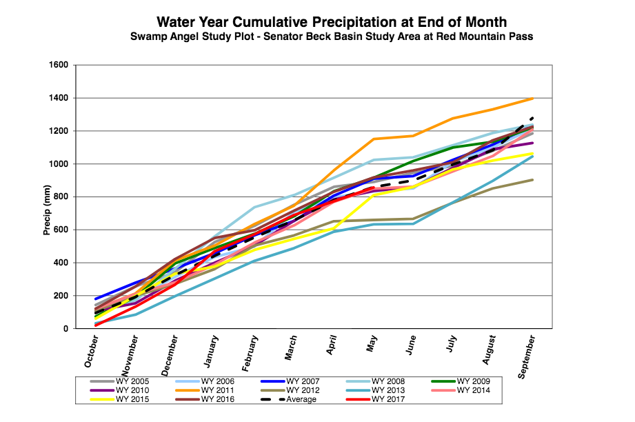
- Cumulative annual precipitation graph by month
| Past Winter Storm Reports: |
See our Current Conditions for the latest hourly data. All times shown are in Mountain Standard Time (MST)
- CSAS Storm Definition >= 12 mm SWE with no break in precipitation >12 hours
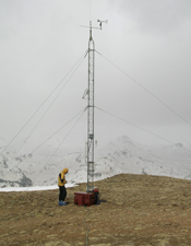
- SASP =Swamp Angel Study Plot(11,060′, in sub-alpine meadow)
- SBSP =Senator Beck Study Plot(12,186′, on alpine bench)
- PTSP =Putney Study Plot(12,323′ alpine ridge ‘free air’ site)
Storm Report #17 and #18
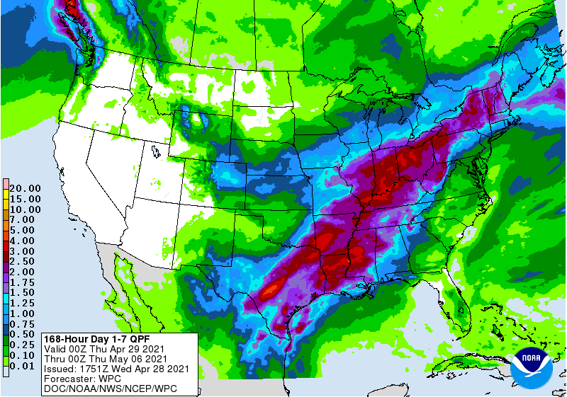
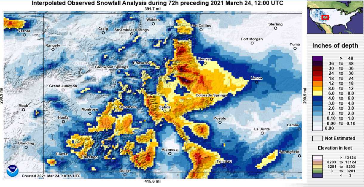
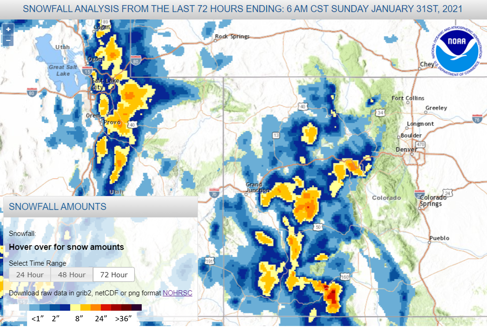
Over a 23 hour period, starting on Friday, May 21 at 2:00am thru midnight, Swamp Angel at Red Mt Pass observed 2.3” of precipitation that accumulated as slightly more than 1’ of snow. At the Senator Beck site at 12,200’ 1.2’ snow accumulation was observed. Obviously this was a high intensity storm, over the 23 hours accumulation rates were typically 2-5 mm/hr. I took a quick glance at past storm reports and don’t think we saw similar accumulation rates since maybe 2019.Being late spring the precip fell as wet snow at Red Mt Pass – and caught many drivers off guard – and little lower around Silverton the streets remained clear of snow with traces of accumulation in the nearby mountains that quickly turned to water.Of course a very welcome hit of water in the parched Southwest Colorado. As a prelude, May 17-18 (Storm #17) was also a storm delivering 0.7” precipitation. Before that our last storm was April 27, 21 days with not much moisture during that time.Storm reports will be posted to the website later this week as a power outage created a temporary glitch.
To add to the snow, yesterday evening dust imagery products showed dust in the Four Corners region and the NWS in Grand Junction observed airborne dust. The wet snow at higher elevations will quickly give way and allow this new dust to quickly meld with the already merged multiple dust layers on the snow surface. With this all dust layers will be merged near or at the surface of the remaining snowpack. We will be sampling this dust and providing more observations this week.
Take Care
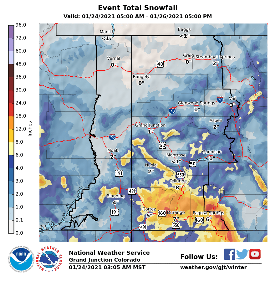
Storm Report #15 and #16, April 27, 2021: First Storm Since April 15
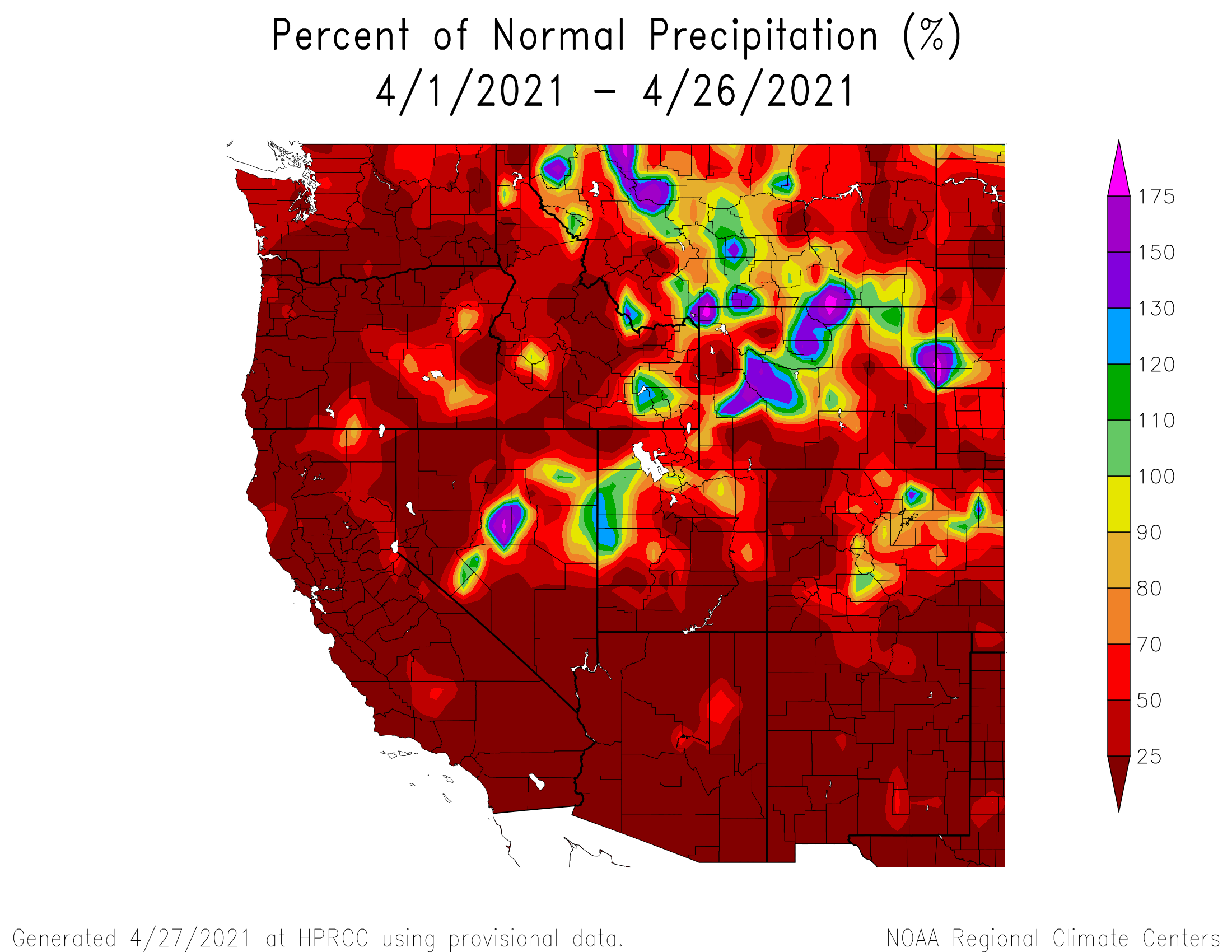
Over 22 hours on Tuesday, April 27, Swamp Angel received 0.6” precipitation as 7” snow accumulation. This marks the first storm since April 15, 11 days. During that time we noted a few minor scatterings of snow that only amounted to 0.6” precipitation, so far not exactly a wet spring in this region. See the precip image below for April.
Follow these links for storm report #15 and storm report #16. We were on CODOS tour during storm #15 so didn’t get that report out the door as quickly as liked.
From late Saturday thru Monday we received a 43 hour storm event that dribbled in 0.6″ precipitation and a few inches of snow accumulation as seen at Senator Beck Study Basin. The first half of the storm was out of the south and ushered in our third dust-on-snow event at SBB so far this winter. Wind direction then shifted to mainly out of the N-NE.
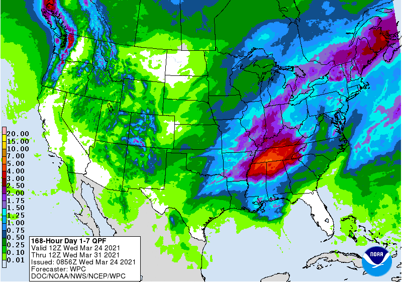
We are currently in the middle of another storm that so far has delivered 0.5″ since Tuesday afternoon. Since Saturday a total 1.1″ precipitation has fallen. The forecast in southern Colorado is for snow through Friday. Fingers crossed we get a few more inches precipitation before the fast approaching ablation season.
Finally, after many days of looking at forecast imagery with lots of deep reds and blues, we got the much anticipated storm event of the winter. For me, I knew it was going to be a big storm by the severity of my barometer induced headache. There are all sorts of forecast tools. Only if there was a way to feed this information into a model.
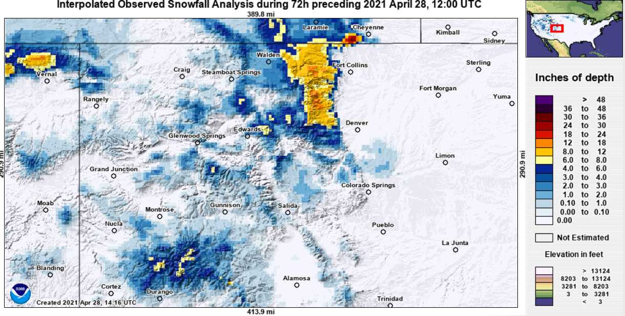
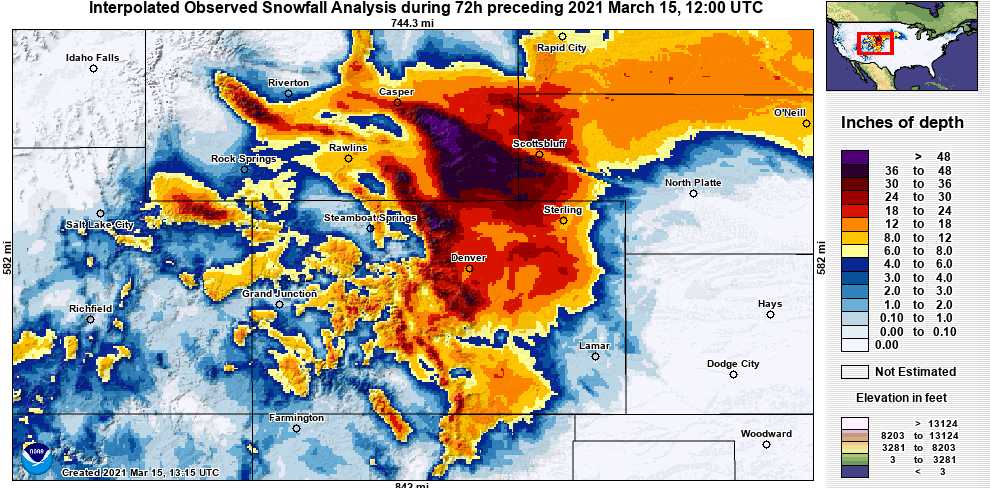
But it was extremely variable where in the mountains the precipitation landed. Saturday morning we woke up with just a couple inches on my truck in Silverton (only 6.7” snow accumulation at Swamp Angel at 11,060’), while over the hill I was seeing reports of Telluride getting close to 20”. So, feeling a little left out. But by the end of the day Saturday we slowly made a little headway and were up to a foot accumulation as 1.2”of water. By Monday morning, in our study basin the storm totaled 1.5″ precipitation with 19″ snow accumulation.
To mix things up for a change the Front Range was the real winner from this productive system. Snow totals are shown below, but some highlights: Fort Collins hit right around ~17″ of snow, DIA just over 27″ and is Denver’s 4th largest storm on record. 3′-4′ in the Northern Foothills. This is a great boost for the Central and Northern Front Range Mountains, other Colorado mountain areas continue to struggle like the Colorado mainstem down to the southwest basins.
Front Range Dust Event: Do you see a faint dust layer in your backyard snow profile? Some folks (NWS Boulder, Russ Schumacher, and other seasoned observers) on the Front Range reported a very discernable dust layer. Send pictures if you do. It came up through New Mexico. Lofted from the playas in Mexico.
More soon.

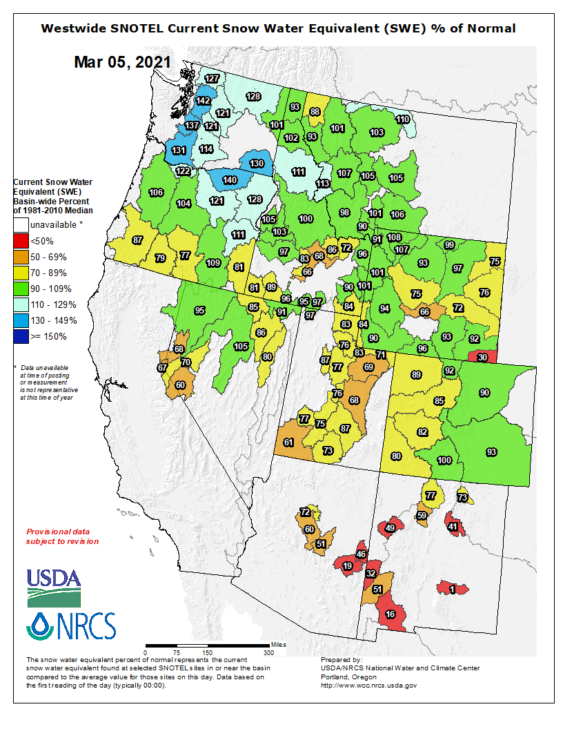
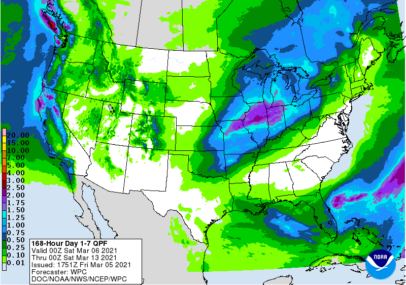
Here at Senator Beck Study Basin 0.55” precipitation fell mostly from midnight March 3, to 5am March 4. A fast moving system but very productive while it was here. As to be expected, the overall dry conditions around Colorado has the snowpack falling further behind from even a week ago, where the mid-February storm cycle that put some basins within 90% of median is diminishing. And its been getting warm over these last few days, this afternoon at our Putney climate station at 12,327’ it is above 0 degrees C. I am not ready for spring, or summer, it sure would be nice to have a winter 2020/21 redo.
It looks like the next chance for precip is not until Tuesday. Break out the sunscreen.
Take Care
Firstly, if you have not completed our survey please do so. We wish to understand what resources you use and what you value about Center for Snow. Your responses will help shape where we focus our energy:
Secondly, after a series of underwhelming storm systems that worked their way through the Northwest San Juan Mountain region this past week we finally saw a productive storm like the kind you read about in the papers. Over 31 hours starting 7 pm on Monday Swamp Angel received 1.4” precipitation as 16” snow accumulation. Winds were out of the NW-NNW with a peak gust of 56.8 mph and hourly gusts ranging from 20-40 mph.
Total over the last 6 days we received 2” precipitation as 20” snow accumulation. Check in with the CoCoRaHS map to see what volunteer observers measured in your area. This week brought a good boost to the snowpack statewide and now hopefully the active storms tracks will continue. The longer-term forecast still reflects the La Nina setup we have seen all winter, namely, increased chances of drier than normal conditions in Colorado.
See the impressive video of an avalanche in Commodore Basin, which is adjacent to Senator Beck Study Area.
Remember to register for the Western Water Assessment’s webinar “Snowpack Monitoring in the Rocky Mountain West, Part 1”, scheduled for February 25.
Take Care
The string of storm systems that started here in the North San Juans on Friday and ended Sunday have come to pass bringing a total of 0.7” precipitation to Swamp Angel at Red Mt Pass. The observed values collected by the precipitation bucket are verified by the 6.4” measured snow accumulation. Storm #9, being the snow that fell Saturday into Sunday brought only 0.47” precipitation, the minimum amount to be considered a storm. Even though the last few days did not bring a huge amount of snow to the Red Mountain area it was still a welcome boost to most areas of the San Juan Mountains and Colorado mountains in general. SNOTEL plots for most basins show a nice bump upwards with increases of SWE over the last 10 days around 1.5”-2”; Yampa saw a 2.1” gain, Animas 1.8”, Gunnison 1.5”, Colorado mainstem 1.5”, Rio Grande 1”, and Colorado as a whole saw a 1.5” gain.
Luckily there is still more to come in the forecast. In the North San Juan there is a winter advisory with heavy snow expected tonight thru tomorrow. This system looks to benefit all of Colorado but it appears the Southern and Northern Basins the most.

Wind gusts predominantly in the 40’s out of the south ushered in storm #8 that started Friday early morning and ended Saturday afternoon. The majority of the snow however fell Friday late afternoon and ended Saturday morning. Air temperatures stayed chilly but Saturday was sunny and clear making for highway 550 being melted off by mid-morning and the new snow making good snowballs by noon. The Southern San Juan Mountains appears to have accumulated the most from this system with a solid foot in some locations.
The forecast is encouraging with the next storm arriving Wednesday morning. Weather models are still thinking this system over, but wherever this system choses to land it looks to contain a good amount of moisture.
More Soon.

Greetings from Silverton,
As of this writing on Tuesday afternoon the latest system comprising of Storm #7 is working its way through the Colorado Mountains depositing light to moderate snow in southwest Colorado and weakening as it heads north. The system will be mostly out of the area by this evening. Storm #6 and #7 both came up from the Four Corners region thus benefited the southern basins and not so much the central and northern basins.
All told, it has been a productive last few days. We observed 1.9” of precipitation as 1.2’ snow accumulation Swamp Angel. Winds were pretty high on occasion over the last 4 days with gusts reaching 53 mph on Friday and 46 mph on Saturday, so a lot of wind redistribution of snow especially at higher elevations as seen in the fluctuating snow depth at the Senator Beck station.
The next system we are eyeballing looks to arrive Friday evening and as of right now appears will deliver 3-8” depending on location.
More Soon


Greeting from Silverton,
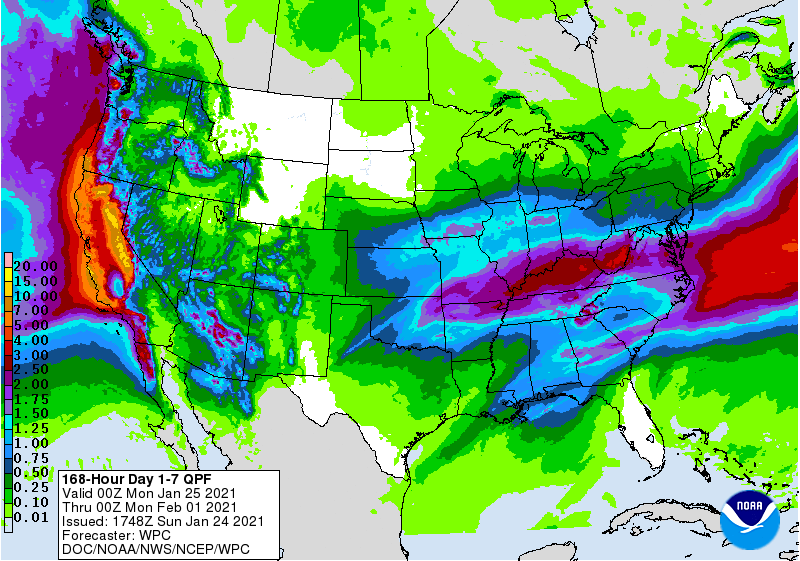
Finally, as a welcome reprieve from the ridge that has dominated most of winter, Southern Colorado received it’s first storm since the end of December occurring Friday (Jan 22) thru Saturday (Jan 23). The welcome precipitation delivered 0.7″ precipitation at Swamp Angel near Red Mountain Pass. The San Juan’s benefitted the most from this first wave in a wave of storms over the next few days. Saturday afternoon was the calm period as another system entered our region from the south early Sunday morning (Jan 24). Last night and today we chalked up another 0.47″ precip, making for 1.2″ precipitation since Friday. Yet another system is expected to crank up out of the Four Corners Monday thru Tuesday. And to keep things interesting the forecast is tracking another trough to arrive on Saturday. Expect another storm report once this current system has exited to the east. And hopefully another soon after that.
Take Care

Another system is currently working it’s way across the Four Corners region. Since early this morning we have seen 1 mm/hour of precipitation and a few inches accumulation. The NWS sees most mountain areas receiving 2-4” with a few locations seeing 6” accumulation by tomorrow morning.

See Storm Report #3 and Storm Report #4 here.
More Soon,
Jeff Derry
Greetings from Silverton,
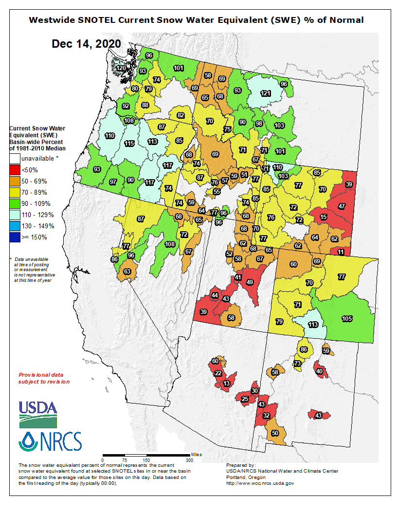
A 2-day storm moved through Colorado delivering a nice swath of snow from the southern San Juans to the Arapaho National Forest west of I-25. Here at Red Mt Pass it was a little slow to arrive but eventually amounted to 1.1” precipitation with 12.9” snow accumulation. West of highway 550 the San Miguel and Dolores basins benefitted the most with some areas approaching 3’ accumulation. Ski resorts welcomed this boost in building the snowpack as well. With ski season upon us make sure you check the avalanche forecast on the CAIC website before heading into the backcountry. There is light precipitation in the forecast for the southern mountains and north/central mountains, but beyond that the outlook for the week is dry.
Have a safe and relaxing Thanksgiving weekend.
Greetings from Silverton,
After a dreadfully hot and dry summer and autumn it was refreshing to see a big early season storm roll through the San Juans and central mountains in two waves starting early on Saturday, November 7 and diminishing Monday night. Our first winter storm of the season occurred October 25-26 and brought 0.7” precipitation mostly in the form of snow at higher elevations but had largely diminished over the last couple weeks except for northerly slopes. The October storm really helped get a handle on the Ice Fire just outside of Silverton and also brought the first dust-with-snow event of winter (we will cover that soon in a CODOS update).
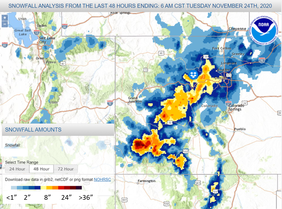
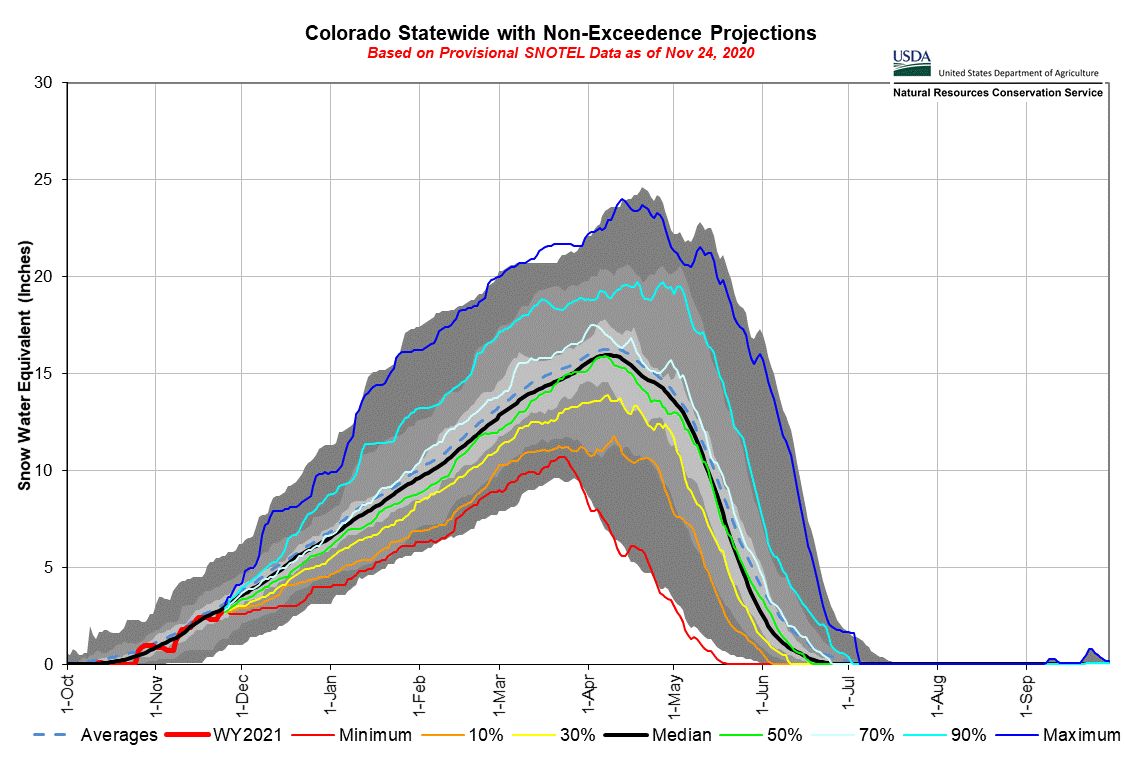
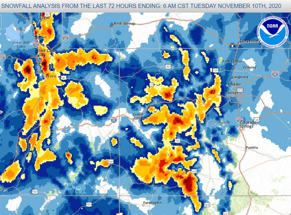
We now have full snow cover in the San Juans with the November 7-9 storm delivering a welcome 3.1” of precipitation and approximately 30” of snow accumulation. At the above treeline Senator Beck station we are seeing 16” snow depth. Early on a good bit of the falling precip was likely rain but gradually turning to snow. Wind gusts went over 100 mph early on as well. The central and southern mountains received mostly in the 12” – 24” range. The big winner was the Southern San Juans, Wolf Creek SNOTEL now sits close to 3.5’ snow accumulation. Last year at this time we did not begin to build the snowpack until the latter part of November.
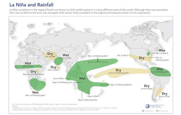
The near-term forecast is calling for generally warmer and drier than normal conditions. The current ENSO forecast is for moderate or possibly strong La Niña conditions through winter. Below is what precipitation might lean towards around the globe. With Colorado sitting in the transition zone, La Niña can generally mean wetter and cooler towards Northern Colorado and dryer and warmer towards Southern Colorado. Nothing is a given and hopefully this storm report is the first of many this winter.
