CODOS Update - New Years 2013
2013 Greetings from Silverton –
We hope you all had a happy holiday break with family and friends, enjoying what snow you could find!
First, the good news. As of this date, we have observed only a single dust-on-snow event here at our Senator Beck Basin Study Area, the D1-WY2013 event on November 9, 2012. That event deposited a little over 1 gram of desert dust, per square meter, in Senator Beck Basin. A photograph of a snowpit performed in early December on Grand Mesa by a Colorado Avalanche Information observer also showed that D1 layer near the bottom of the snowpack. The D1 layer may also be present at other locations north and east of Senator Beck Basin, but probably only on northerly aspects. Here in the western San Juan Mountains, D1 played a role in the virtually complete loss of snow cover (including the snow containing D1) on southerly (SE, S, SW, and W) aspects during the remainder of November, but a complete absence of additional precipitation that month also drove that process. Where snow cover did persist through November into early December, the D1 layer is now buried deep in the snowpack, just above the ground, out of reach of solar radiation.
By January 1st, prior to this season, the early winters of 2010/2011 and 2011/2012 had produced the highest and lowest cumulative precipitation totals in our period of record, ranging from 414 mm of total precipitation from 9 Storms by the end of December 2010 compared to just 271 mm, from 10 Storms, by the end of December, 2011. This year has established a new low mark for October-December total precipitation, at just 197 mm, from 8 numbered winter Storms.
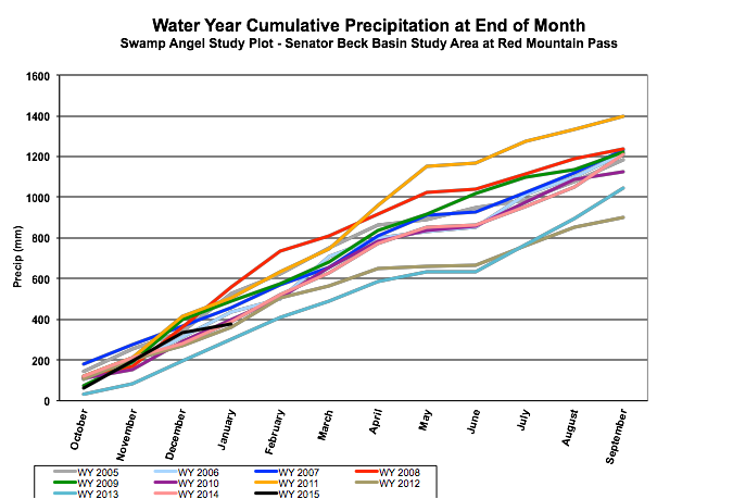
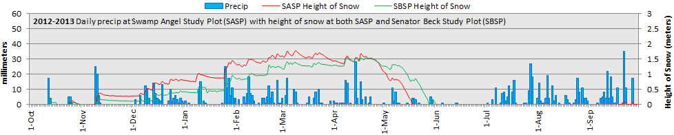
Unfortunately, and somewhat paradoxically, the inauspicious start to Water Year 2013 continued through December despite a series of 7 weather events in December that met the CSAS’s criteria for “numbered” winter Storms. Unfortunately, several December 2012 Storms barely achieved our Storm precipitation threshold of 12 mm (0.5”) of water. The most recent Storm #8 did meet our 12 mm threshold, and other criteria, but also exhibited the lowest rate of precipitation intensity we have ever dignified as a "Storm". Given such minimal Storms, December 2012 total precipitation, at 113 mm, fell well short of our 10-year Swamp Angel Study Plot average of 135 mm for the month (but did exceed the December 2011 total of just 72 mm). Further, for the first time in our ten-year period of record, the height of snow (snowpack depth) at Swamp Angel Study Plot did not reach 1 meter by January 1 and last summer’s vegetation stalks were only recently covered. Nonetheless, the study plot was a pretty scene on Christmas morning, with 20 cm of fresh “fluff” and clearing skies.
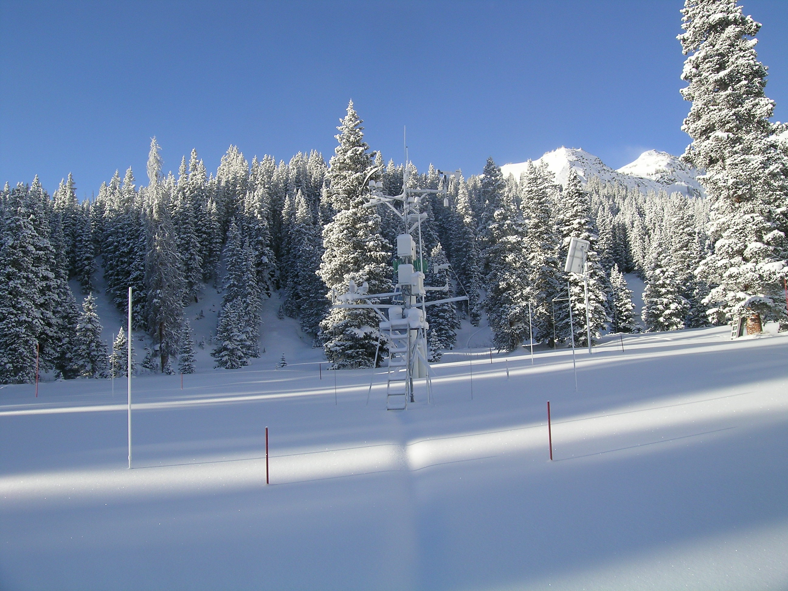
Swamp Angel Study Plot on Christmas morning, 2012
Snowpack formation in the western San Juan Mountains, as in most of the state, is lagging, perhaps even more than current Snotel data indicate. As of January 1, 2013 the nearby Red Mountain Pass Snotel site is reporting 67% of average SWE. Like most Snotels, the Red Mountain Pass site is well shaded and, as a result, did retain snow cover during the completely dry period between Storm #1, November 9-10, 2012 and the first subsequent snowfall on December 3, 2012. However, by December 3rd, nearly all snow cover had disappeared on most “warm” aspects (SE, S, SW, and W) in the Red Mountain Pass vicinity. Some early winter snowpack ablation on warm aspects is normal but, as a consequence of the dry fall, the amount of bare ground exposed in the western San Juan Mountains in early December, all the way to ridge lines, was highly abnormal.
We are concerned that current Red Mountain Pass Snotel data may actually overstate general SWE conditions in the Red Mountain Pass locale, as a consequence of those unusual snow cover conditions in early December, when effectively no SWE was present on warm aspects, at any elevation. The same binary state of snow cover existed in the headwaters of the Animas, Dolores, Uncompahgre, and San Miguel watersheds, with “none” present on S’ly aspects and “some, but thin” snow cover on N, E, and higher elevation 'level' terrain, such as Swamp Angel Study Plot. Given its proximity, the same conditions likely also existed in the Rio Grande headwaters immediately southeast of Silverton. We have not traveled to or obtained similar observations of snow cover conditions elsewhere in the state. Some ranges have certainly fared better than our western San Juan Mountains, including the Wolf Creek Pass and San Juan River headwaters, and you may have your own sense of how November snow cover evolved and the representativeness of Snotel SWE data in your own watersheds.
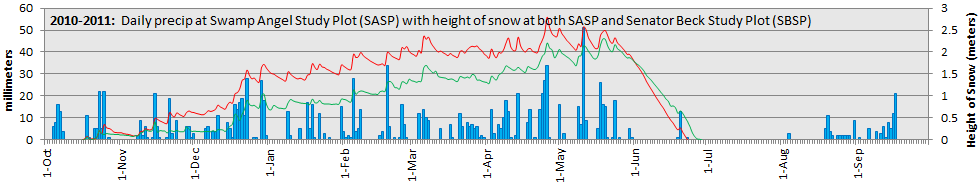
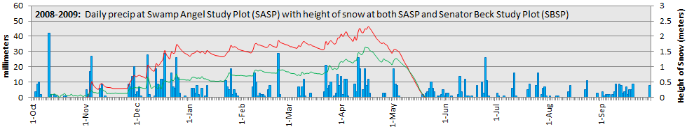
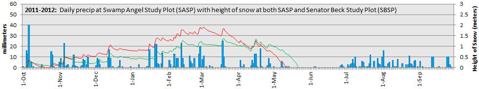
Variations in precipitation are revealed in the following graphs of day-to-day precipitation at the sub-alpine Swamp Angel Study Plot (SASP, in blue bars) and of snowpack formation at SASP (in red) and the alpine Senator Beck Study Plot (SBSP, in green). While we do experience mesoscale or microscale precipitation at SASP, from 'local' weather dynamics, most of our winter precipitation is delivered by large, synoptic scale weather events, tallied as "Storms" in our accounting. However, a comparison of December 2012 (seven Storms) and December 2008 (six Storms) reveals that a similar number of early winter synoptic scale weather events can produce vastly different amounts of precipitation. (These graphs and other Water Year plots since 2004 are also presented at: https://snowstudies.org/data/graphs/precip.html).
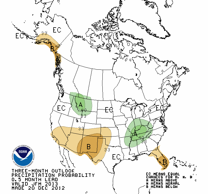
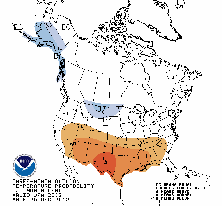
As of December 20th, NOAA's Climate Prediction Center precipitation outlook for Jan/Feb/Mar 2013 foretells no major change in fortunes for Colorado.
CPC's temperature outlook for the Jan/Feb/Mar period is also unfavorable.
As of December 25th, drought conditions in the Colorado mountains are ranked Severe to Extreme (below), and conditions in the Colorado Plateau dust source areas are also rated Severe to Extreme. Notably, much of northeast Arizona is rated Extreme. As has been the case, the drought tendency for Colorado and the Colorado Plateau remains classified "persistant". Persistent drought conditions in the Colorado Plateau are unhelpful, and we have no new evidence to suggest that dust emissions during late winter and spring will be less likely than in recent years. However, day-to-day, synoptic scale weather events in the source will still determine the availability of dust at the ground surface and whether that dust can be mobilized, elevated, and then transported over long distances and deposited in the Colorado mountains.

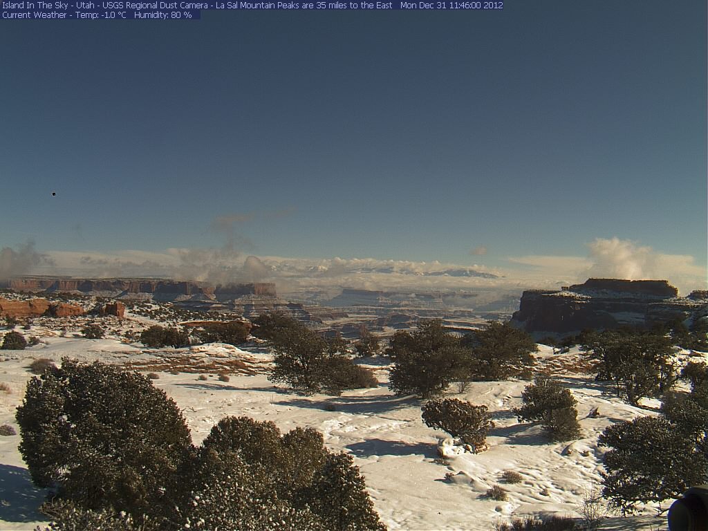
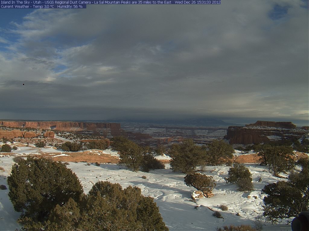
Portions of the dust source area have received recent snowfalls, as seen in this photo from the USGS Arid Lands program camera at Island in the Sky, in Canyonlands National Park looking east toward the La Sal Mountains.
However, local weather can and does result in local dust-on-snow events within the source area, as seen in the photo below, taken from the same location on December 31st. No new dust-on-snow was observed at the Senator Beck Study plot during that period. Unfortunately no comprable imagery is available from dust source areas in northeastern Arizona.
Given the nature of this winter to-date, we will continue these Updates of snowpack formation, even absent additional dust-on-snow, and report any new dust events, of course.
More soon,
Chris
Chris Landry, Executive Director
clandry@snowstudies.org
Center for Snow and Avalanche Studies
PO Box 190, Silverton, CO 81433 USA
(970) 387-5080
www.snowstudies.org

