D2 had limited extent,
approaching winter storm to blanket Colorado Plateau -
As anticipated in our Feb 9 D2 Alert, we've been in touch with snow observers elsewhere in the state, many of whom work for the Colorado Avalanche Information Center, and learned that the D2 event may have been confined to the western-most areas we monitor, namely our westernmost San Juan Mountains and Grand Mesa. That limited spatial extent for event D2 will be confirmed during our first CODOS tour, in March, but is good news for now.
Here at home, patches of dust layer D2 made a brief appearance on wind-scoured terrain around Red Mountain Pass late last week. Strong winds, mostly from the north, peeled off as much as a foot of overlying snow in exposed areas. D2 was never exposed at our Swamp Angel Study Plot and some 6" of new snow fell on Sunday night, under very calm winds, and reburied those exposed patches of D2, at least temporarily. At lower elevations here in the western San Juan Mountains, particularly on southerly aspects, and where present, D2 may still be exposed and absorbing solar energy. Here in Silverton, some thinly covered, south-facing slopes where D2 had emerged recently became wet (isothermal) throughout during warm and sunny days (but certainly refroze at night, with lows in the -15 to -20 F range lately). D2 was also observed on the surface of lower elevation snowcover near Ouray on Sunday. Recent Animas and Uncompahgre stream gauge data do show increases in diurnal fluctuation in their (very low) flows and D2 may be contributing to those daily variations from static 'base' flows.
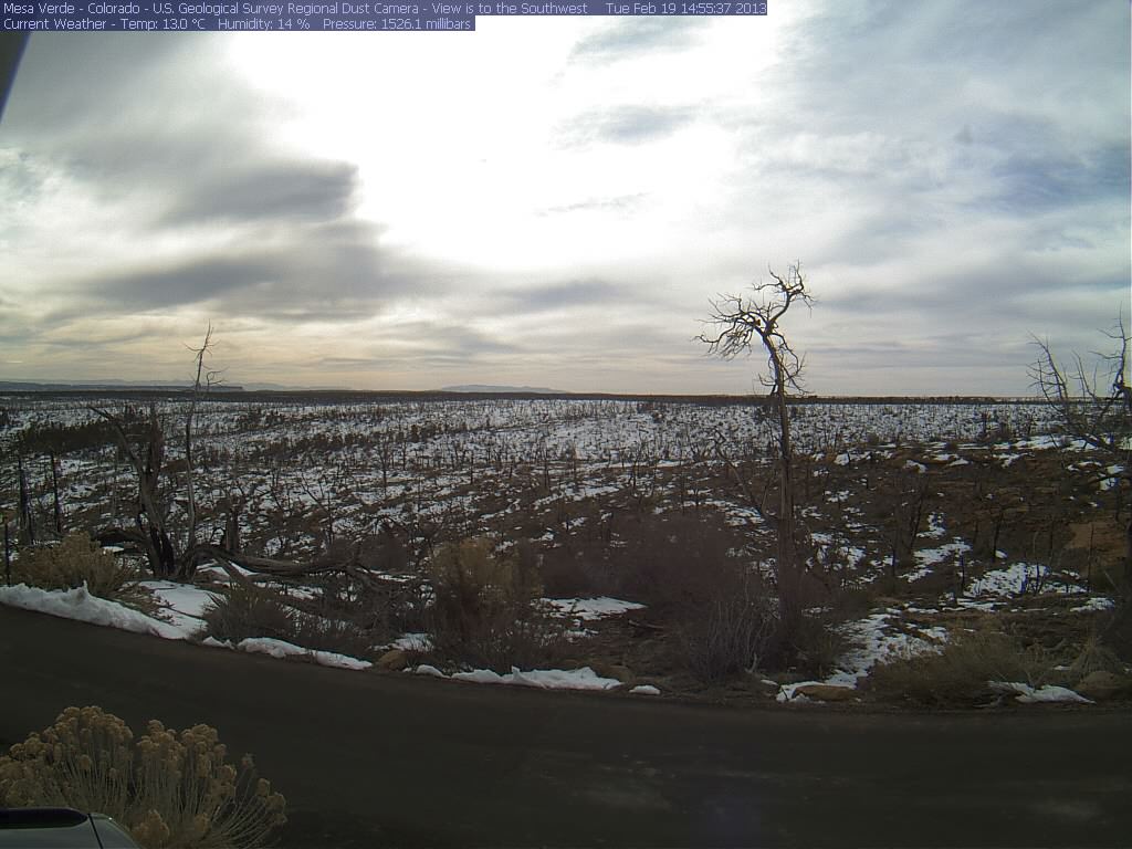
An unsettled period of wintry weather is ahead for much of Colorado. The southern mountains of Colorado are favored with the approaching storm, named Winter Storm Q by the Weather Channel, which will begin here tonight. Moderate S'ly winds are expected here during the approach of this storm, averaging 15-25 mph, shifting to WNW tomorrow afternoon/evening. The National Weather Service in Flagstaff also expects moderate winds as the storm approaches and enters the Colorado Plateau, with winds gusting into the 30's at Winslow, AZ this afternoon (as of this writing, winds are just picking up, now SW at 14 mph, gusting 23 at the Winslow airport, under clear skies). NWS predicts a 30% chance for rain in Winslow after 11 PM tonight, turning to snow as the snow level drops to 5,100'. Not surprisingly, USGS webcams show no visible sign of blowing dust to our southwest, as seen in the Mesa Verde cam, and Storm #13 (a week ago) and more recent precipitation may have precluded another dust storm, given these predicted winds.
Better still, the National Weather Service also expects very substantial snowfall over much of the Colorado Plateau and has issued the following Winter Weather Message:
URGENT - WINTER WEATHER MESSAGE NATIONAL WEATHER SERVICE FLAGSTAFF AZ, 504 AM MST TUE FEB 19 2013
AZZ005-009>014-039-040-192015-
/O.CON.KFGZ.WW.Y.0006.130220T1200Z-130221T0300Z/
MARBLE AND GLEN CANYONS-
NORTHEAST PLATEAUS AND MESAS HWY 264 NORTHWARD-CHINLE VALLEY-
CHUSKA MOUNTAINS AND DEFIANCE PLATEAU-
LITTLE COLORADO RIVER VALLEY IN COCONINO COUNTY-
LITTLE COLORADO RIVER VALLEY IN NAVAJO COUNTY-
LITTLE COLORADO RIVER VALLEY IN APACHE COUNTY-BLACK MESA AREA-
NORTHEAST PLATEAUS AND MESAS SOUTH OF HWY 264-
INCLUDING THE CITIES OF...PAGE...LEES FERRY...KEAMS CANYON...
KAIBITO...CANYON DE CHELLY...CHINLE...KAYENTA...WINDOW ROCK...
GANADO...WUPATKI N.M....TUBA CITY...WINSLOW...HOLBROOK...
SNOWFLAKE...ST. JOHNS...SPRINGERVILLE...NAVAJO N.M....DILKON...
KYKOTSMOVI
504 AM MST TUE FEB 19 2013
...WINTER WEATHER ADVISORY REMAINS IN EFFECT FROM 5 AM TO 8 PM
MST WEDNESDAY FOR HEAVY SNOW AND BLOWING SNOW...
* TIMING...EXPECT ACCUMULATING SNOW TO BEGIN WEDNESDAY MORNING
AFTER 5 AM MST. THE HEAVIEST SNOWFALL WILL OCCUR FROM 5 AM TO
3 PM MST. SNOW SHOWERS WILL DECREASE WEDNESDAY NIGHT.
* SNOW ACCUMULATION...ABOVE 6000 FEET ELEVATION EXPECT 6 TO 12
INCHES BY WEDNESDAY NIGHT. FROM 5000 TO 6000 FEET EXPECT 3 TO
6 INCHES. FROM 3000 TO 5000 FEET EXPECT 1 TO 3 INCHES. LOCALLY
HIGHER AMOUNTS ARE POSSIBLE.
* OTHER IMPACTS...PLAN FOR HAZARDOUS WINTER DRIVING CONDITIONS.
TRAVEL WILL BE CHALLENGING DUE TO SNOW PACKED ROADWAYS AND
REDUCED VISIBILITIES IN SNOW AND BLOWING SNOW.
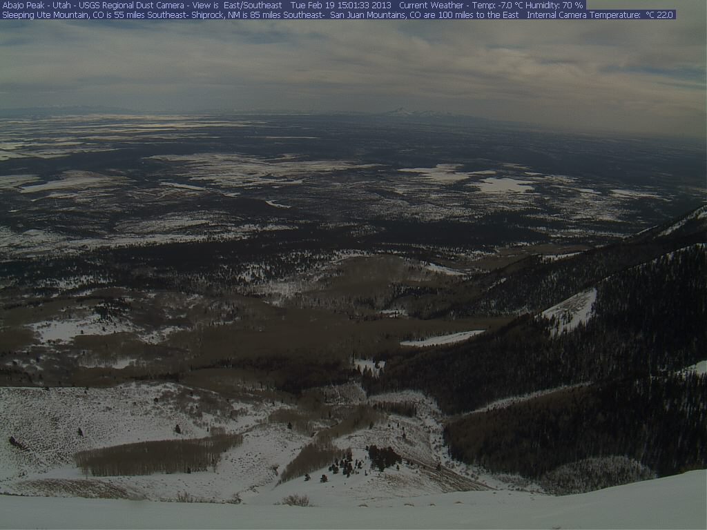
Larger amounts are expected in Flagstaff and the Mogollon Rim, under a Winter Storm Warning for up to 20" or more. The Salt River watershed is developing a enough snowpack that the local Silverton river rats are gearing up for river trips there next month ... brrr. Lesser amounts of mixed rain and snow are expected in the lower elevations of southeast Utah, with light to moderate winds. The Cortez area has prospered with substantial snowfalls in the 7-10 days and snowcover is extensive in much of the nearby SE Utah terrain, as seen in this image from the USGS Abajo Peak cam (looking southeast). Winds are currently calm at the Cortez airport.
Last, the NOAA Climate Prediction Center issued a new US Drought Outlook on Feb 7th. The new map representation varies from prior maps by indicating a tendency toward "Some Improvement" in drought conditions in much of the Colorado Plateau. Storm #13 (Feb 8-10) and the approaching "Storm Q" are certainly helpful, in that regard.

Naturally, we will check our new snow and report any new dust, should we find some. Otherwise, we'll hope for the best for the Colorado mountains and our drought-stricken neighbors on the Colorado plains from the coming series of winter storms.
More soon,
Chris
Chris Landry, Executive Director
clandry@snowstudies.org
Center for Snow and Avalanche Studies
PO Box 190, Silverton, CO 81433 USA
(970) 387-5080
www.snowstudies.org

