Center for Snow and Avalanche Studies

      CODOS Quick Links

Colorado Dust-on-Snow (CODOS)
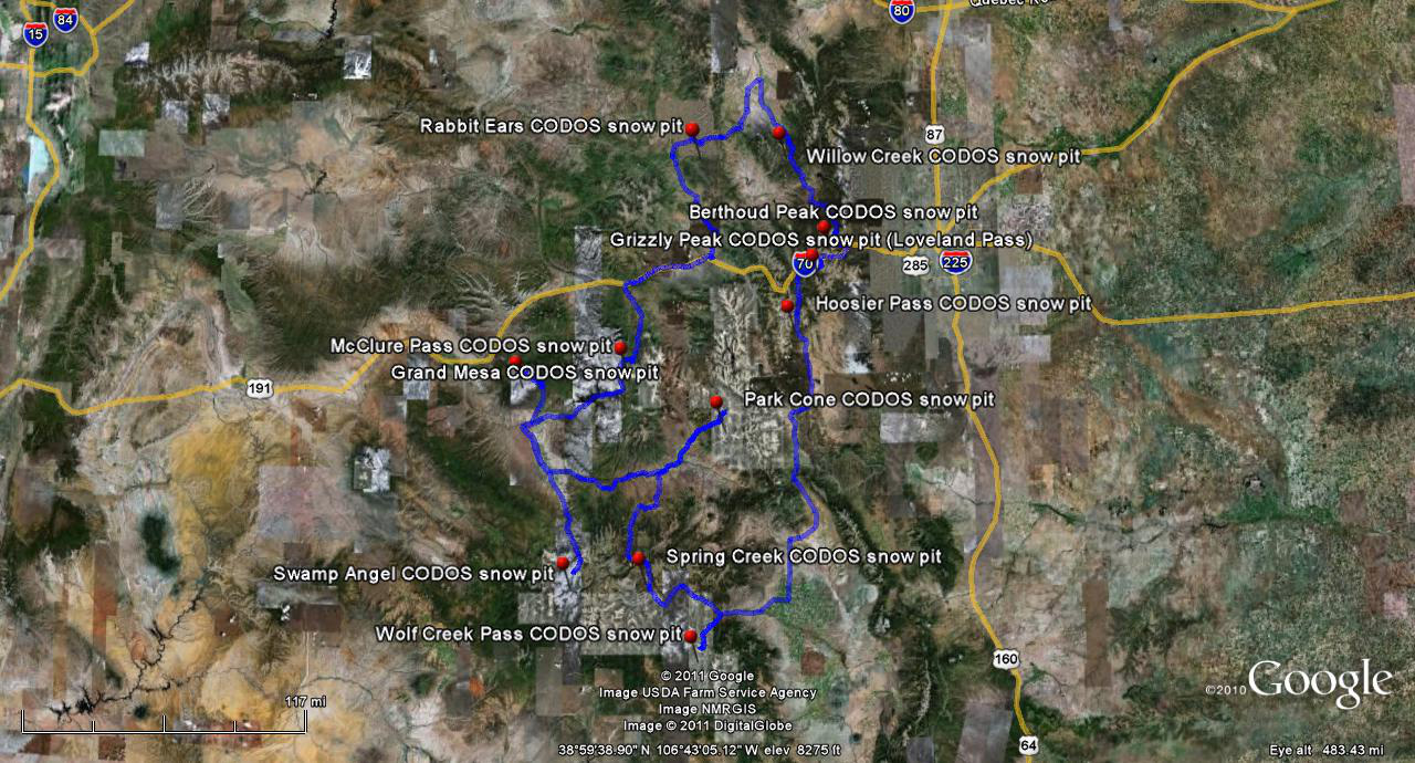
With direct funding support from stakeholders, CODOS monitors the presence/absence of dust layers at 11 mountain pass locations throughout Colorado.

With those data, data from nearby Snotel sites, and weather forecasts, CODOS provides its funders with a series of “Update” analyses of how dust-on-snow is likely to influence snowmelt timing and rates during the snowmelt runoff season.


Become a Friend of CSAS:
The Center for Snow & Avalanche Studies serves the mountain science community and regional resource managers by hosting & conducting interdisciplinary research and conducting integrative 24/7/365 monitoring that captures weather, snowpack, radiation, soils, plant community and hydrologic signals of regional climate trends.
Follow snowstudies on Twitter

Find us on Facebook


     CODOS Updates > Dust-on-Snow Event D6-WY2013, April 8

CODOS Alert - Dust-on-Snow Event D6-WY2013, April 8

Good morning from Silverton.  As feared, strong winds in advance and during the onset of the ongoing winter storm (named Walda by the Weather Channel, our CSAS Storm #19) did deliver a significant dust-on-snow event to the western San Juan Mountains.  Reports of raining mud, muddy snow, and dusty air were widespread in southwest Colorado.  Given the strength of this event, it's plausible that many or most Colorado mountain locales received this dust event as well.  The first hints of dust, mixed with snowfall, came in the early afternoon.  Around 4 PM the weather lifted briefly and billowing clouds of dust were unmistakable (below). Heavy dust was in the air here in Silverton as darkness fell yesterday, Monday evening (April 8).   

We have about 3" of new snow on the ground in Silverton as of 7 AM this morning and it's calm and snowing very lightly.  We've measured 20 mm (0.8") of water content in 10" of dense snow at Swamp Angel Study Plot, since noon Monday.   Another surge of moisture is approaching the southern mountains and NWS expects an additional 7-11" at Red Mountain Pass today.  So far this storm has favored the mountains south of I-70, but a wind switch this afternoon should benefit the northern mountains, according to the NWS Grand Junction forecast discussion this morning.

More soon,
Chris

Chris Landry, Executive Director
clandry@snowstudies.org
Center for Snow and Avalanche Studies
PO Box 190, Silverton, CO 81433 USA
(970) 387-5080
www.snowstudies.org