 CODOS Update for Senator Beck Basin Study Area:
Visited April 10, 2013
CODOS Update for Senator Beck Basin Study Area:
Visited April 10, 2013
Summary | Snowpack | Melt Rate | Stream Flow | Wind | Forecast
Summary
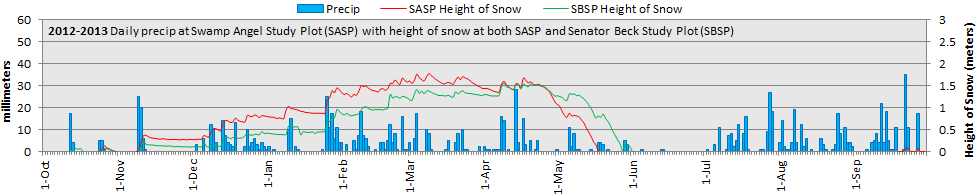
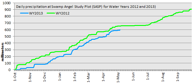
Dust-on-snow layer D6, deposited April 8, has become a dominant feature of the sub-par western San Juan Mountain WY 2013 snowpack. As a result of dust enhanced surface snowmelt in late March and early April, snowcover at the Swamp Angel Study Plot (SASP) at Senator Beck Basin is now isothermal and snowmelt discharge measured at the Senator Beck Stream Gauge has risen, slightly, from winter base flow. Winter storms in March and early April have resulted in SASP snowcover containing more SWE than was present at this time in spring 2012 but WY 2013 total precipitation continues to lag behind WY 2012. (Storm #20 is in progress as of this writing, Sunday, April 14.)
SnowPack Discussion
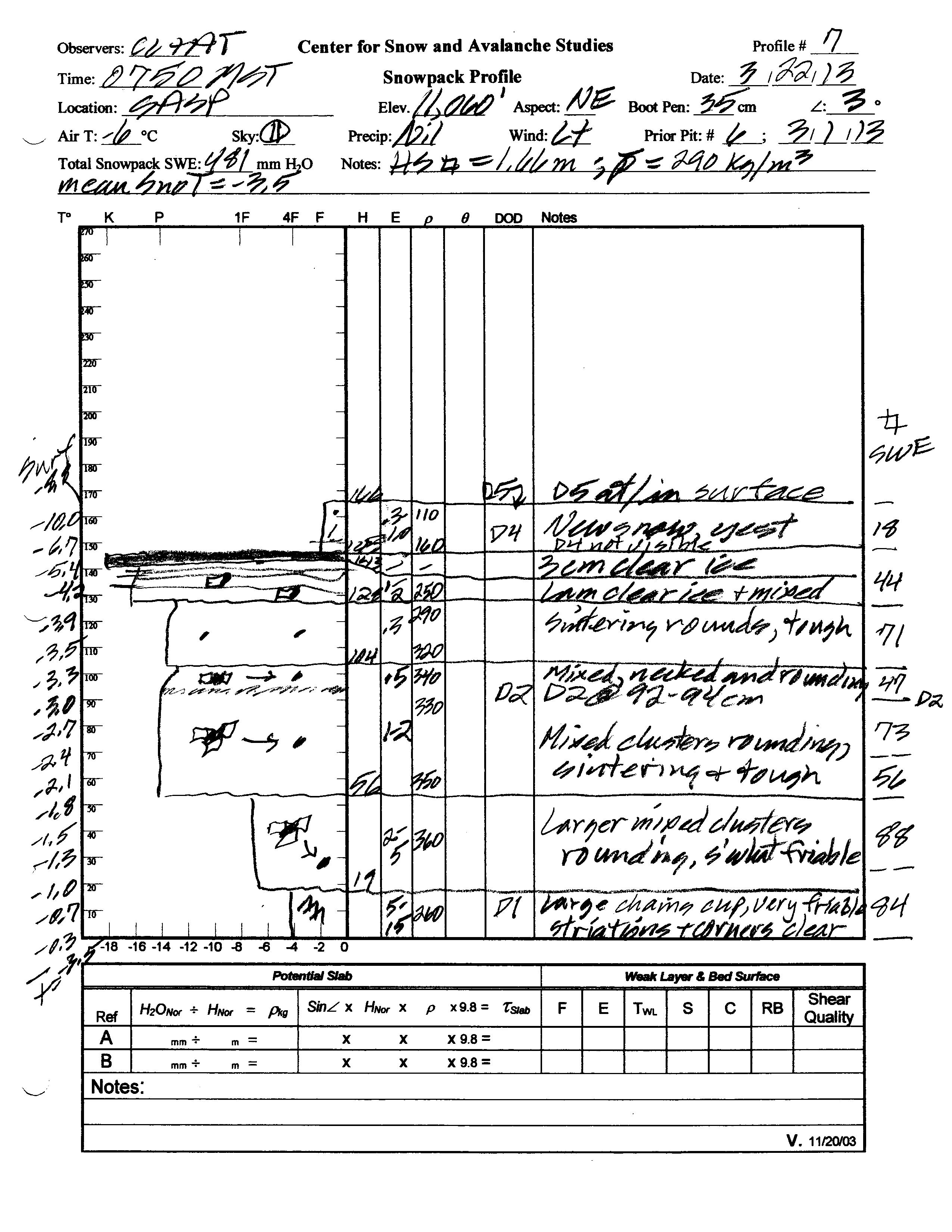
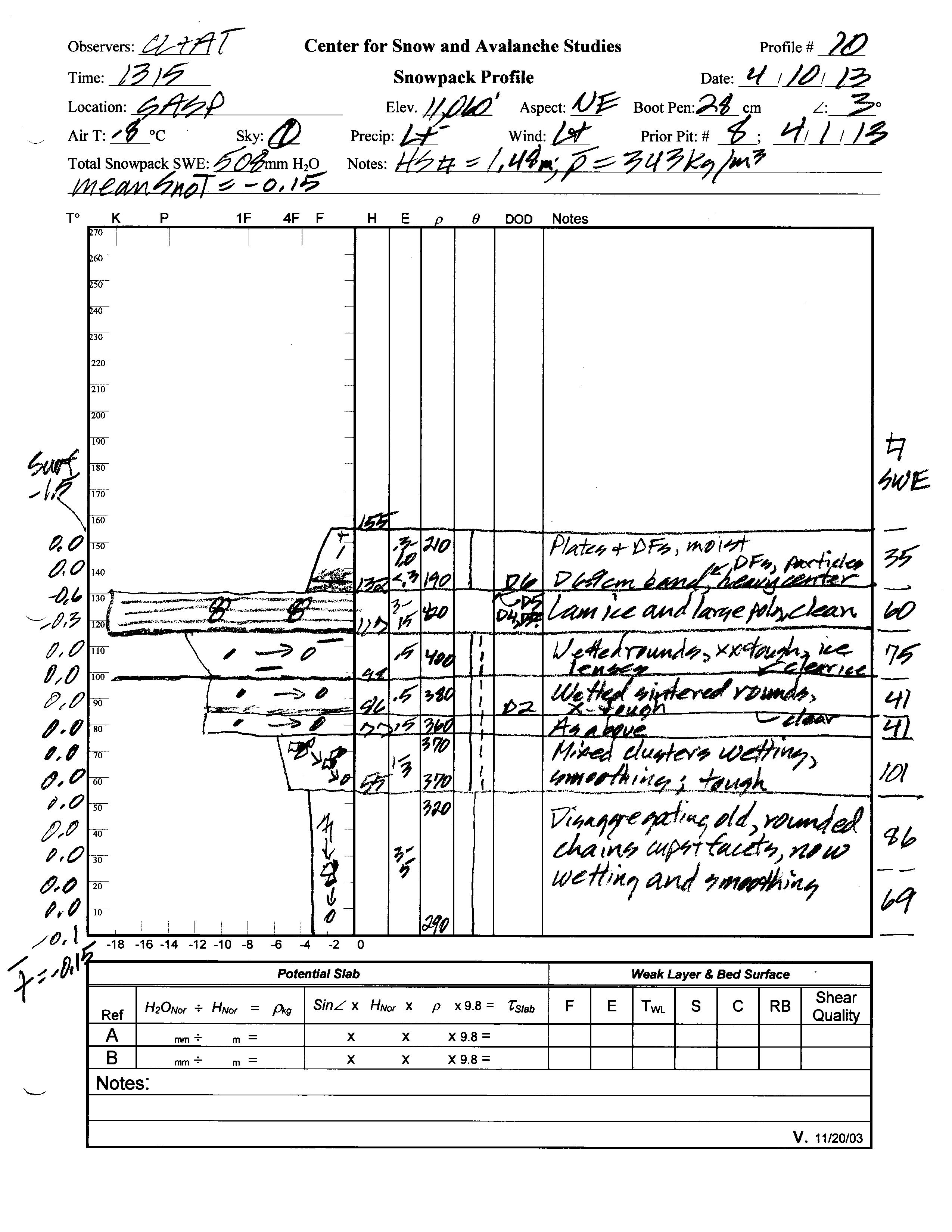
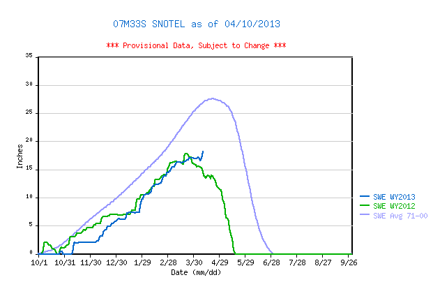
Although the snowpack at Swamp Angel Study Plot (SASP) did experience small declines in depth during March and early April, occasional storms partially recovered those losses (in depth). Total snow depth in our April 10, 2013 SASP snow profile was 61”, about 4” less than observed at the site on March 22, 2013, and total SWE on April 10 was 20.0”. Even with less depth, more SWE content resulted in mean density of the snowpack on April 10, 2013 at 343 kg/m3 (34.3% water content) versus 290 kg/m3 (29.0% water content) on March 22, 2013. The nearby Red Mountain Pass Snotel, 1 mile to the south and at a similar elevation, reported 18.2” of SWE that morning, 1.1” less than measured at SASP.
The top 9” of the snowpack on April 10, 2013 consisted of Storm #19 snow containing the very heavy dust-on-snow event D6-WY2013 (April 8). Underneath that Storm 19 layer a thick band of barely re-frozen melt-freeze polycrystal layers, interspersed with layers of ice, contained merged D5/D4/D3 dust. Dust layer D2 was clearly visible mid-pack. Most of the snowpack was either moist or near-wet and all layers showed evidence of recent wetting, by percolation of free water from the surface. The snowpack was effectively isothermal, with a mean snowpack temperature in this profile of -0.15° C, as compared to -3.5° C on March 22, 2013.
Red Mountain Pass Snotel data as of April 9, 2013 places current SWE near the middle of the lower quartile of SWE values for the period of record but higher than the same-date value recorded in WY 2012, thanks to March 2013 precipitation. A new storm (#20) is underway as of this writing (on Sunday, April 14) and will add another 1” plus SWE to the snowpack. As of April 9, 2013 data at the Lizard Head Pass Snotel, located 14 miles to the southwest of Red Mountain Pass, show SWE still well below the 1971-2000 mean for that site, and very nearly identical to the same-day value in 2012.
| March 22, 2013 Pit Profile | April 10, 2013 Pit Profile | |
 |
 |
|
 |
 |
|
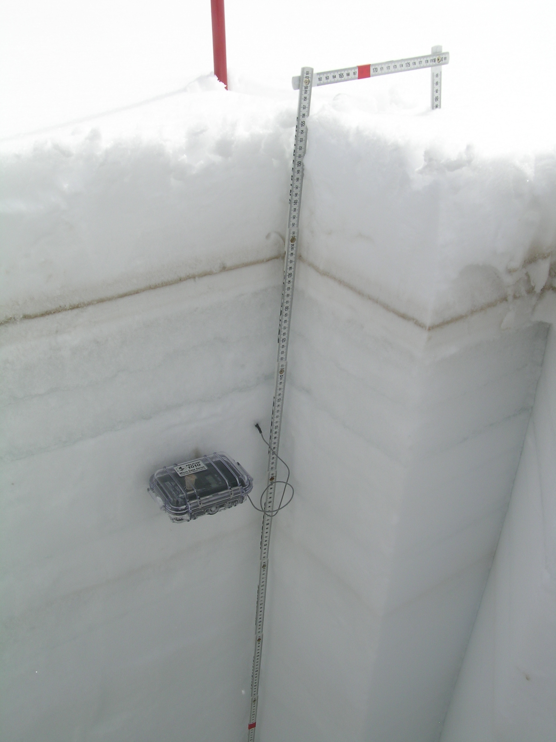
| Upper Swamp Angel Study Plot snowpack on April 10, 2013. Dust-on-snow layer D6 (April 8) is prominent, with a very dark central band surrounded by more diffuse dust above and below. Dust layers D5, D4, and D3 are merged in a thick melt-freeze polycrystal band below the D6 and Storm #19 snow, but do not stand out in this photo. |
Lower SASP snowpack on April 10, 2013, with dust layer D2 seen just below the thermometer case. |
|
 |
||
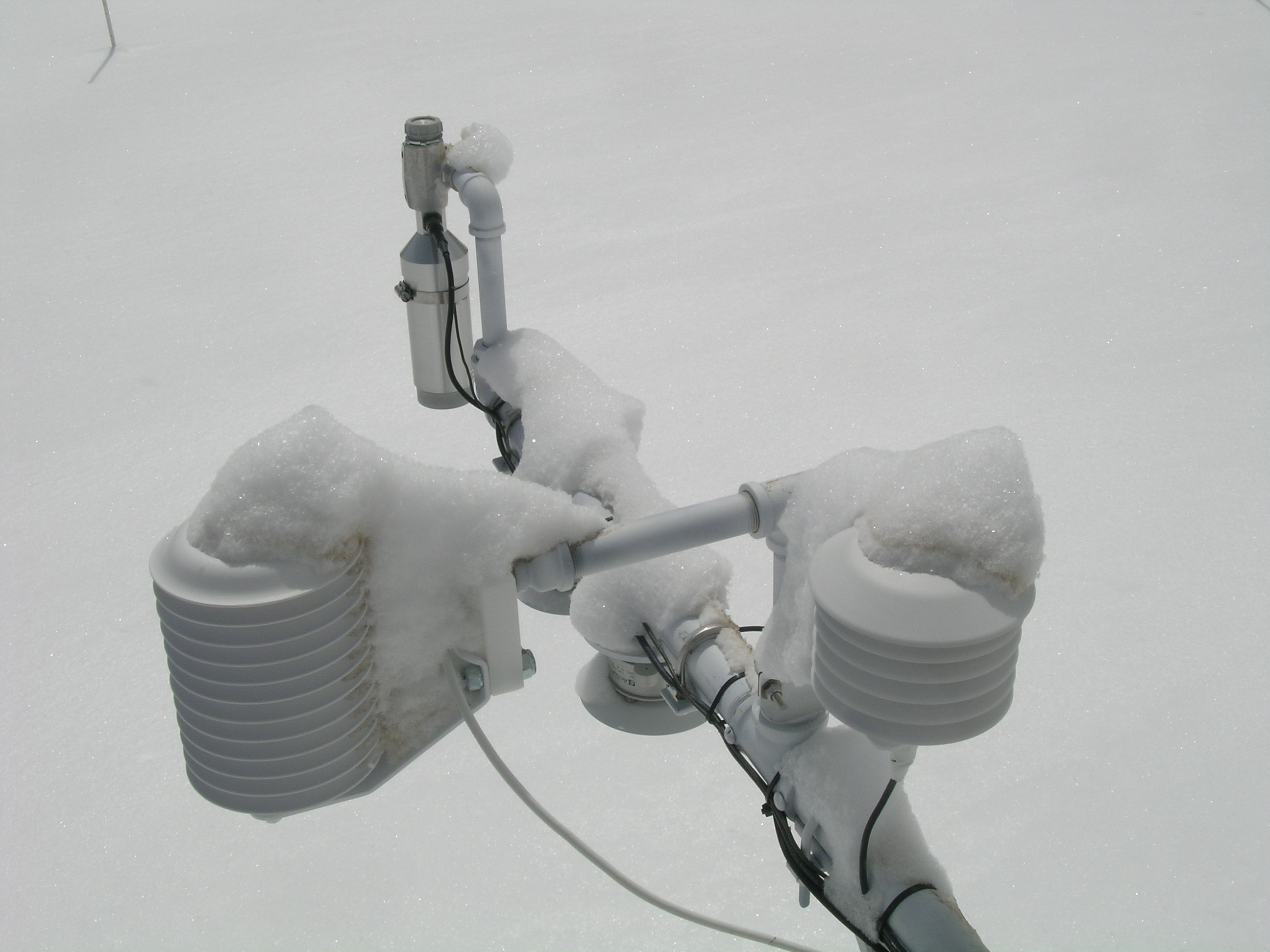
D6 dust in Storm #19 snow on the instruments at the Swamp Angel Study Plot. |
||
Melt Rate
The Red Mountain Pass Snotel site continues to accumulate SWE, albeit at a slower rate. However, the isothermal snowpack at Swamp Angel Study Plot (SASP), with dust layers D5/D4/D3 merged and exposed at the surface, the snow grain characteristics in our April 10 profile, and the recent increased discharge at the Senator Beck Gauge all indicate that some snowmelt discharge has occurred in the lower elevations of Senator Beck Basin, even as SWE also increased at SASP. New snow from Storm #19 (April 8-9) briefly stalled the active melting occurring at the snowpack surface but the D6 dust contained in that storm was absorbing solar energy during our field session. Snotel data from Lizard Head Pass did record a decline in SWE prior to April 9.
D6 Update, upon return to Silverton on Saturday evening, April 13: Upon returning to Silverton from our CODOS circuit, we observed that dust layer D6 had made a widespread and stunning emergence on April 12-13, progressing rapidly from lower elevations to the higher, cooler terrain. Casual observers are (understandably) mistaking dust layer D6 for bare ground, it is so dark. However, as of this writing (April 14) we are receiving another layer of fresh snow (Storm #20) containing over an inch of SWE, and this will, once again, restore a higher snow albedo and delay the inevitable full emergence and impact of dust layer D6 for a few more days. As and when D6 does more-or-less fully emerge, and remain exposed for some days, snowmelt rates will dramatically accelerate throughout the western San Juan Mountains. SWE loss rates may match those observed in spring 2009 and snowpack ablation to “snow all gone” (SAG) will be significantly advanced, perhaps matching the early dates of SAG in 2012, given the sub-par snowpack.


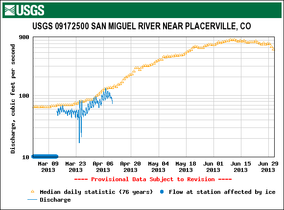
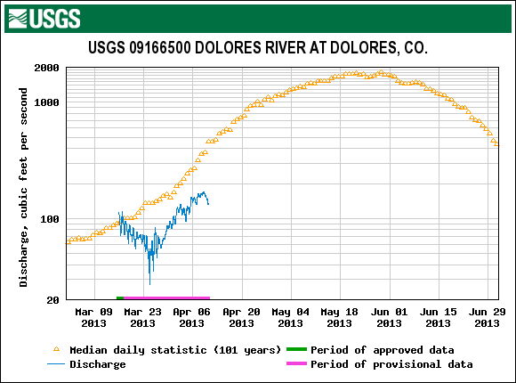
Stream Flow
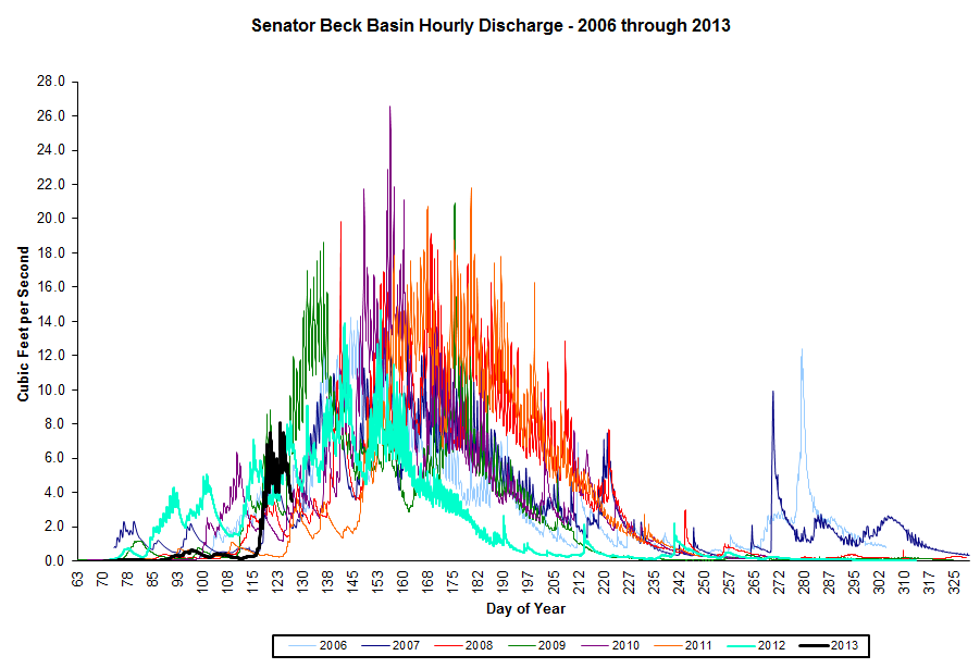
Last spring, by early April 2012, Senator Beck Stream Gauge (SBSG) had already recorded two surges (shown below in turquoise) as a direct consequence of the prolonged exposure of dust throughout that extremely dry and sunny March, reaching discharge rates up to 5 cfs. In contrast, SBSG WY 2013 discharge data (shown in black) show only a small increase in flows so far this spring, as dust layer D5 was exposed and merged with layers D4 and D3. Flows remain very low and we have yet to reach 1 cfs this season. As and when dust layer D6 emerges and remains exposed, discharge will surge sharply and may mirror the acceleration experienced in spring 2009 (shown in dark green), as long as D6 remains exposed. However, those rates cannot be sustained for the same duration as observed in 2009, given our meager snowpack.
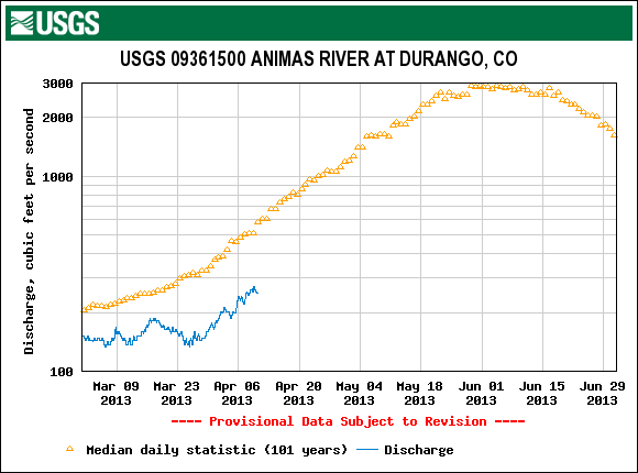
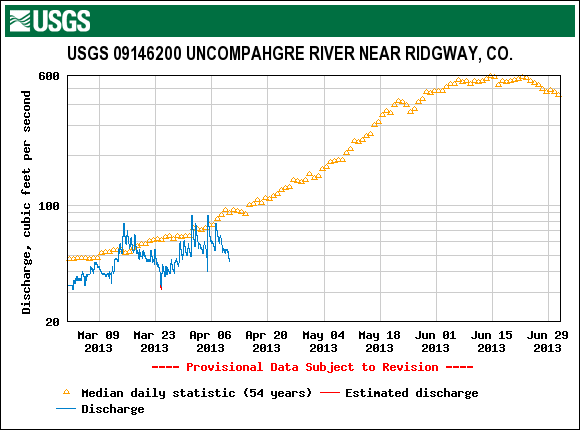
Gauge data from nearby rivers in the San Juan Mountains also recorded small surges in flows in March 2013 driven by lower elevation snowmelt, enhanced by dust layer D5. The brief, partial emergence of dust layer D6 in recent days did not have sufficient duration to produce a significant surge in flows, and Storm #20 (in progress as of this writing on April 14) will delay a potentially major surge driven by D6 until sunny weather returns.

Wind Behavior
The following graphs show wind behavior during the Water Year 2013 dust-on-snow events at our Putney Study Plot (best wind data for Senator Beck Basin Study Area and Red Mountain Pass). We have estimated beginning and end times of each event based on observations from Silverton, CO. For more on this wind analysis, see the CODOS dust log and wind rose table. For comparison, windroses from last season are also posted. WY 2013 has produced two wind and dust storms from the WNW – events D4 and D5. Although the Putney Study Plot location minimizes the influence of local terrain on wind speed and direction, it is plausible that a terrain feature to the due west of the tower, a gentle ridge, is ‘splitting’ and redirecting due west winds into WSW and/or WNW vector(s) at the Putney site. The low frequency of due W winds in our period of record wind rose, adjoined by frequent WNW and WSW fractions of total wind, is the primary evidence of that potential effect.
D1: Nov 9, 2012 |
D2: Feb 8-9, 2013 |
D3: March 5-8, 2013 |
 |
 |
 |
D4: March 17-18, 2013 |
D5: March 21-22, 2013 |
D6: April 8, 2013 |
 |
 |
 |
Forecast
As of Sunday, April 14, The National Weather Service expects unsettled weather to continue through Wednesday, April 17, with snow levels dropping to higher valleys. A significant weather system is expected to arrive Monday with strong winds (Red Flag Warnings posted for southwestern valleys) but snowfall may favor the central and northern mountains. Partly sunny weather may return to the San Juan Mountains by Thursday, but no prolonged drying is anticipated at this time as the weather remains “progressive”, with an another potential system shaping up for next Saturday.
Given additional new snow the week of April 14-20, and without further dust-on-snow, the emergence of dust layer D6 will continue to be elevation and aspect driven, with earliest exposure at lowest snow-covered elevations where new snow totals are lowest. Even on mostly cloudy days early in the week, sufficient radiation may reach the snowpack to penetrate the new snow layer, reaching the D6 layer below and accelerating the ablation of the new snow. Shadier, higher terrain will be the last to exhibit widespread D6 emergence but even those locations will have exposed patches of D6 where wind has stripped away the recent new snow. Regional streamflow data for San Juan Mountain watersheds may reflect the onset of D6-enhanced snowmelt rates by the end of the week, but the full effects of D6 may be delayed until the following week, given drier and sunnier weather then.