 CODOS Update for Senator Beck Basin Study Area:
Visited April 7-8, 2012
CODOS Update for Senator Beck Basin Study Area:
Visited April 7-8, 2012
Summary | Snowpack | Melt Rate | Stream Flows |
Wind Behavior | Previous Update | pdf
Summary
Sustained periods of unseasonably warm air temperatures and exposed dust at the snowpack surface during late March and early April have, together, initiated accelerating rates of snowmelt and SWE loss at some, but not all, CODOS Snotel sites. Some CODOS Snotel sites report significant declines in SWE approaching the lowest values in the period of record (for a given date) or even falling outside of the historic range. Those sites may have experienced Peak SWE for WY 2012 in early or mid-March. Recent CODOS snowpits near those CODOS sites mirror those losses of SWE.
In contrast, even with comparable reductions in snow albedo from the same exposed dust layers, other CODOS Snotel sites and CODOS snowpits show only small losses of SWE. Energy inputs from warm air and direct absorption of solar energy by dust at the snowpack surface was consumed in warming the snowpack towards an isothermal state at 0° C at those generally higher or cooler (N’ly aspect) sites. Our recent snowpits at Senator Beck Basin, at the Swamp Angel and Senator Beck Study Plots, demonstrate this difference in snowmelt rates driven by differences in elevation (slope and aspect are identical at both sites), as the higher Senator Beck Study Plot is only now approaching isothermal.
The National Weather Service expects warming weather in the western San Juan Mountains through Tuesday, April 10th, with a slight chance for afternoon showers on Tuesday. Another round of strong SW’ly winds will develop on Tuesday afternoon. Somewhat more unsettled and cooler weather will finish the week, including slight chances for rain and/or snow showers each day, with temperatures perhaps even falling below seasonal norms by Friday and the weekend.
SnowPack Discussion
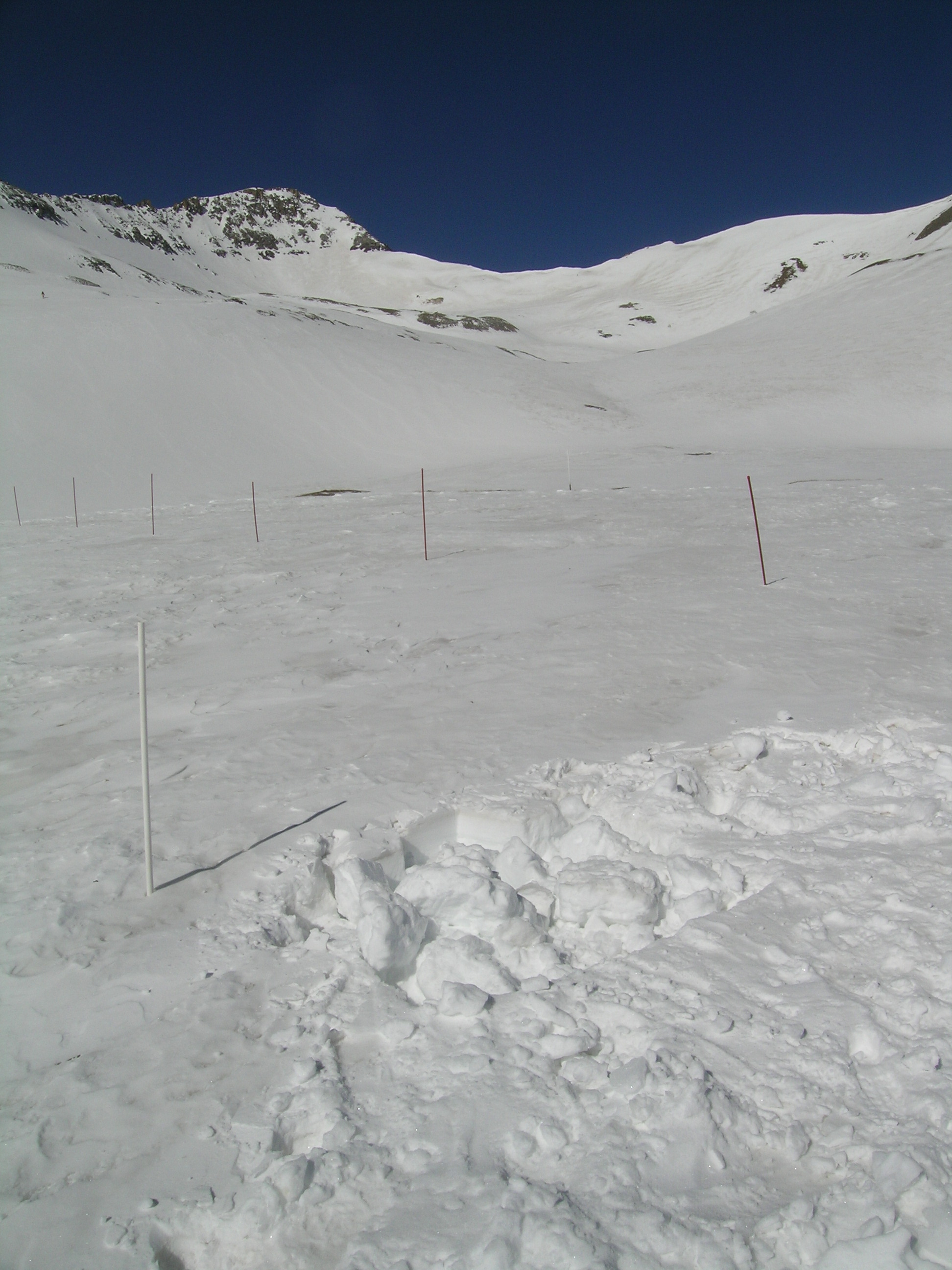
Despite near-constant exposure of dust at the snowpack surface, the Senator Beck Study Plot, at 12,186’, has lost essentially no SWE since our March 28 Update, but the mean snowpack temperature has risen from -3.7° C on March 27 to -1.6° C on April 7. Melt at the Senator Beck Study Plot snowpack surface did result in substantial melt water flux into the upper snowpack where that free water encountered cold snow and refroze, as layers of clear ice up to 2-3 cm thick. Meanwhile, warming from below elevated snow temperatures to near-zero values in the bottom two-thirds of the snowpack.
Minor snow squalls associated with dust-on-snow event D8, April 6th, left a thin layer of dry and dusty new snow scattered over the alpine terrain of Senator Beck Basin. Those patches exhibit a higher albedo than the old snow surface containing D7/6/5/4 dust in between them and will require a day or two of direct sun to melt and merge with the much lower albedo snow underneath.
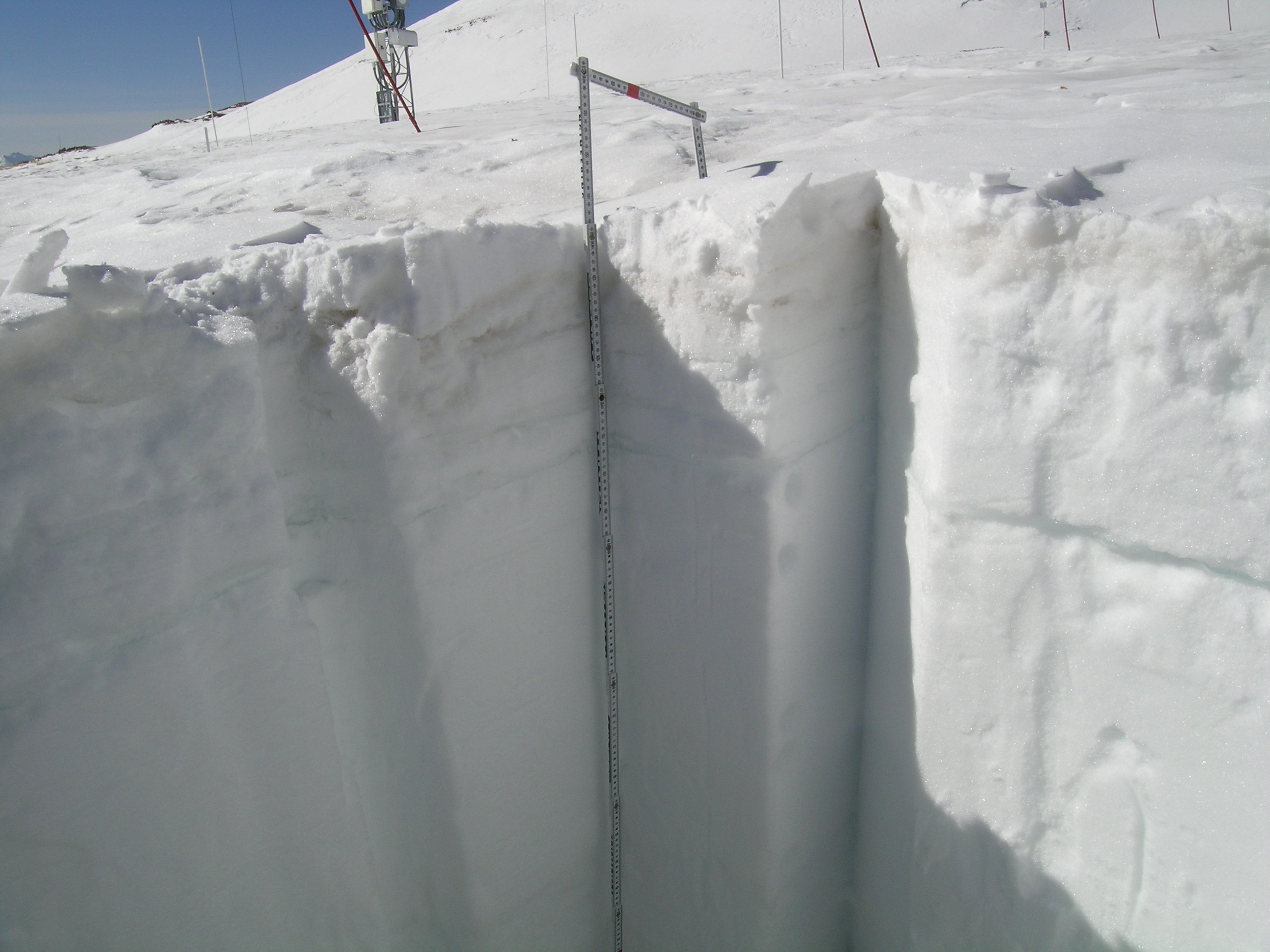
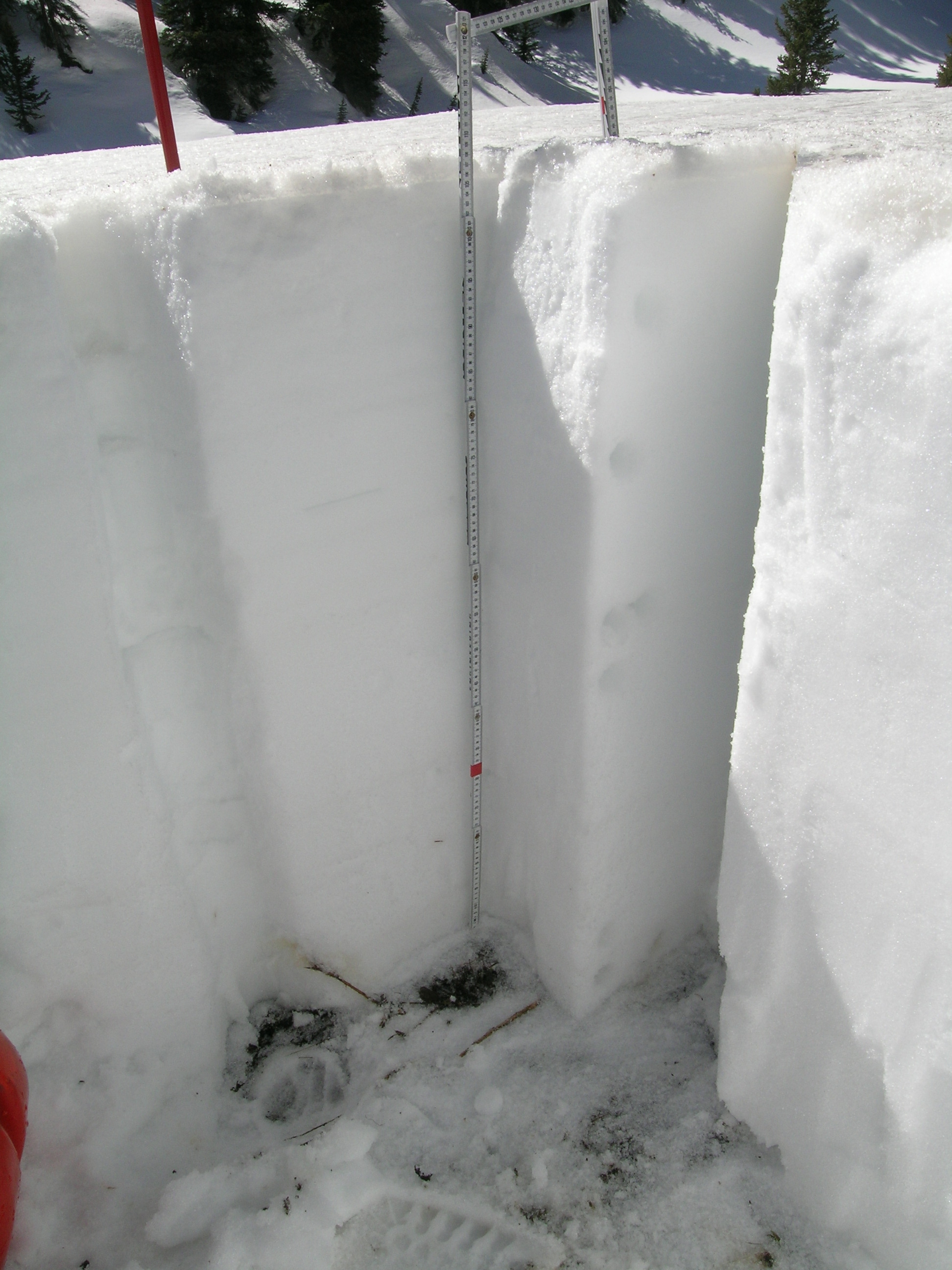
On March 26th the snowpack at the lower elevation Swamp Angel Study Plot, at 11,060’, was effectively isothermal and contained 21.3” (542 mm) of SWE; depth was 61” (156 cm). By April 8th, SWE and total depth had fallen to 17.0” (433 mm) and 42.5” (108 cm) respectively; temperatures were still isothermal. Dust layer D8 had merged with the D7/6/5/4 dust, at the snowpack surface (see photo).
| Senator Beck Study Plot: | |||
 |
 |
 |
 |
SBSP Pit profile for March 27, 2012 |
SBSP Pit profile for April 7, 2012 |
After re-filling the snow pit on April 7, 2012 |
Pit on April 7, 2012 |
| Swamp Angel Study Plot: | |||
 |
 |
 |
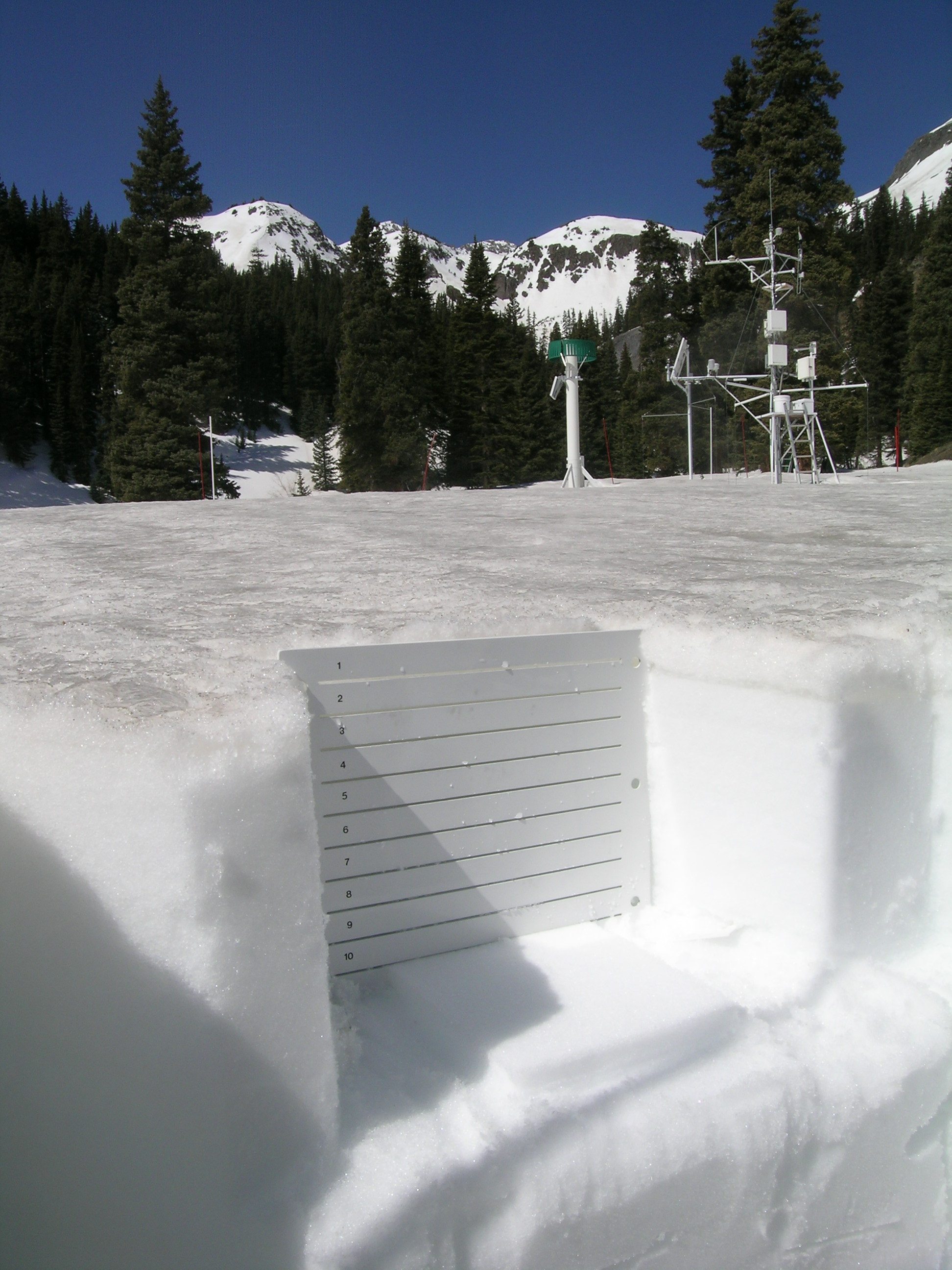 |
SASP Pit profile for March 26, 2012 |
SASP Pit profile for April 8, 2012 |
SASP Snow Pit on April 8, 2012 |
Pit on April 8, 2012 |
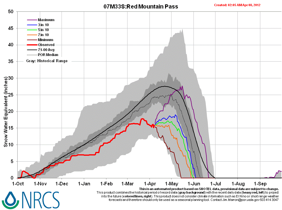
Melt Rate
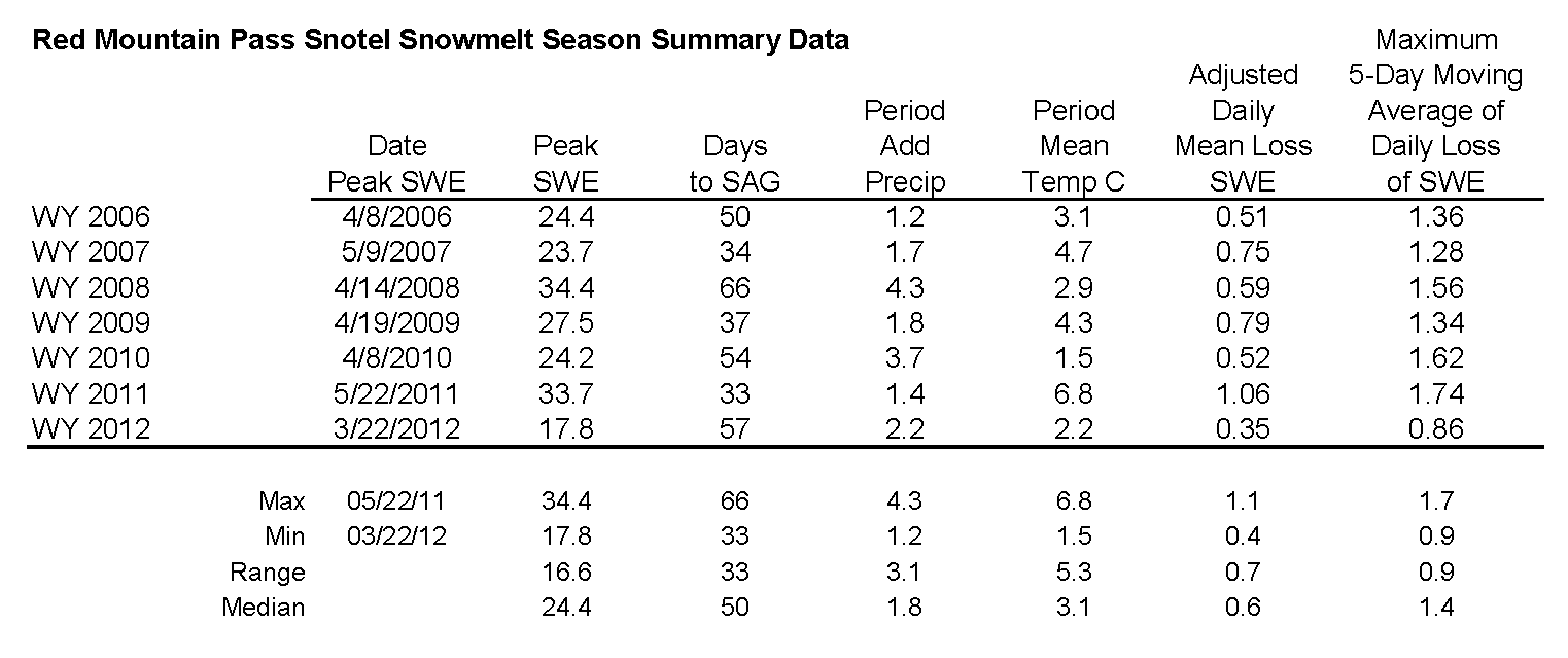
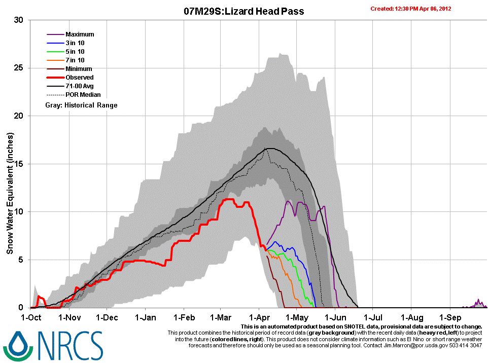
Between March 27th and April 3rd the Red Mountain Pass Snotel, at 11,200’, lost 2” of SWE before a small rebound, much less than the 4.3” (109 mm) loss measured at the Swamp Angel Study Plot from March 26 to April 8. The Red Mountain Pass Snotel site is closely bordered by tall trees to the east, south, and southwest. Farther west, the Lizard Head Pass Snotel (see snowmelt analysis table and Snotel graph), at 10,200’, lost 5” of SWE over the same period and the extremely low SWE levels are barely within the period of record range. Melt rates have approached 1” of SWE loss per day in recent days at the Lizard Head Pass Snotel.
Stream Flows
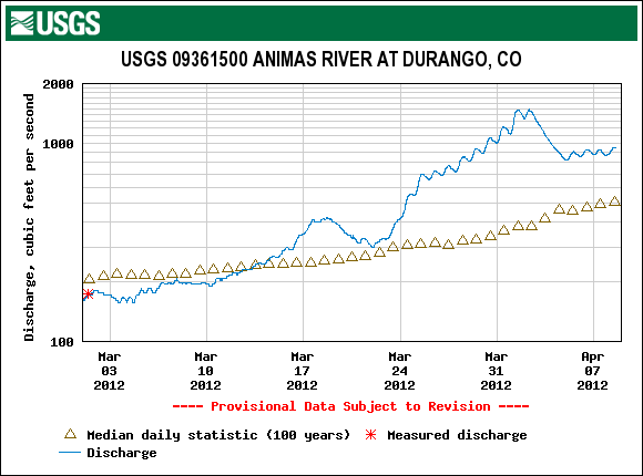
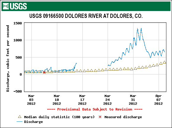
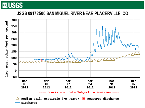
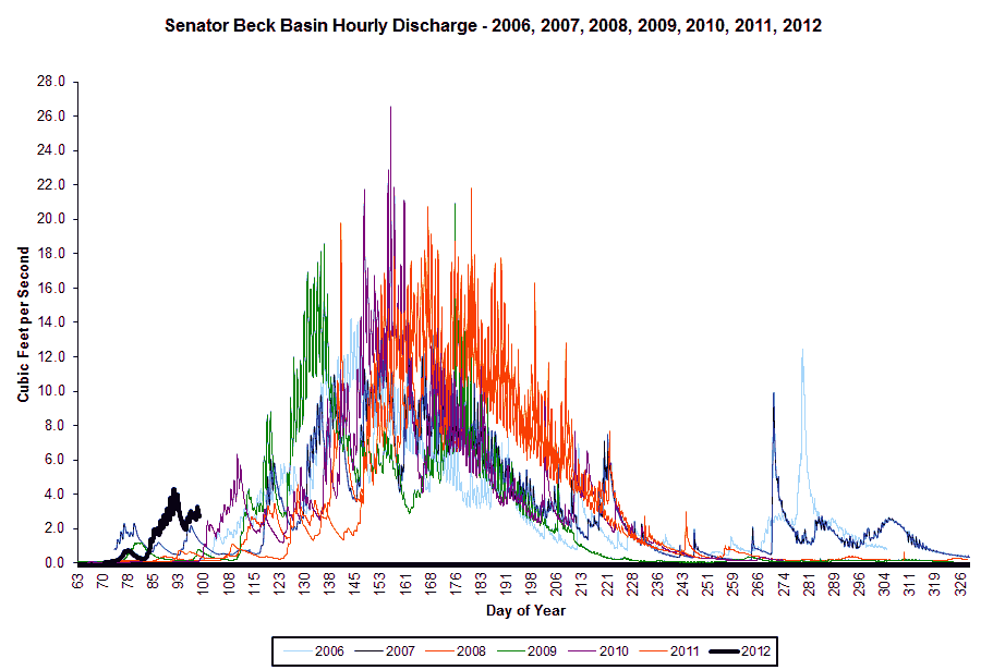
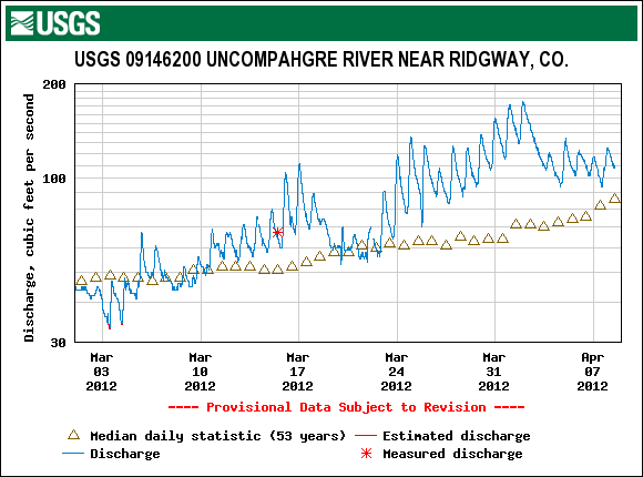
Streamflow behavior at the CSAS’s Senator Beck stream gauge and the USGS Uncompahgre at Ridgway gauge show similar declines in early April, after significant surges in late March. Unsettled weather on April 2, with snow flurries, ushered in cooler air and cloudier skies for the following several days, with another weak weather system following on the 5th. The combination of cooler temperatures, small amounts of new snow briefly increasing snow albedo, and frequently cloudy skies dampened the preceding surge in streamflows. On April 8, surface flows from the rapidly melting sunny slopes at the bottom end of Senator Beck Basin were once again increasing, as was the flow at the stream gauge, as seen in the video link below. Senator Beck Basin total discharge remains quite small, to-date, as much of the upper Basin snowpack is only now approaching isothermal snow temperatures, at 0° C
The effects of early April weather are also seen in the USGS gauge data from the Animas River at Durango, Dolores River at Dolores, and San Miguel River near Placerville.
Wind Behavior
The following graphs show wind behavior during the Water Year 2012 dust-on-snow events at our Putney Study Plot (best wind data for Senator Beck Basin Study Area and Red Mountain Pass). We have estimated beginning and end times of each event based on observations from Silverton, CO. For more on this wind analysis, see the CODOS dust log and wind rose table.
D1: Nov 5, 2011 |
D2: Nov 13, 2011 |
D3: Dec 3, 2011 |
 |
 |
 |
D4: March 6, 2012 |
D5: March 18, 2012 |
D6: March 26, 2012 |
 |
 |
 |
D7: April 1, 2012 |
D8: April 6, 2012 |
|
 |
 |