 CODOS Update for Senator Beck Basin Study Area:
Visited April 30, 2013
CODOS Update for Senator Beck Basin Study Area:
Visited April 30, 2013
Summary | Snowpack | Melt Rate | Stream Flow | Wind | Forecast
Summary
During the final week of April dust layers D8, D7 and D6 emerged at the snowpack surface in the lower Senator Beck Basin Study Area. Snowpack temperatures had become fully isothermal at SASP elevations by mid-April, and were rapidly approaching 0° C throughout the snowpack at the higher Senator Beck Study Plot (SBSP) by the end of April. Snow albedo at SASP fell to ~31% by mid-day April 30, absorbing more than two-thirds of the solar energy striking the surface and forcing snowmelt rates. Snowmelt runoff from Senator Beck Basin surged strongly for the first time this season in late April, and flows lower on the Uncompahgre River, at Ridgway, surged very quickly from sub-average levels to discharge normally observed several weeks later. Dust emergence is rapidly expanding to the highest elevations and coolest aspects of Senator Beck Basin. A wind event subsequent to our site visit produced a very weak dust-on-snow event (D9) but had no significant effect on the already extremely dirty snow surface. No additional snow fell with that event and clear, sunny skies are returning to the San Juan Mountains as of this writing.
SnowPack Discussion
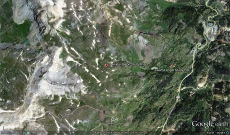
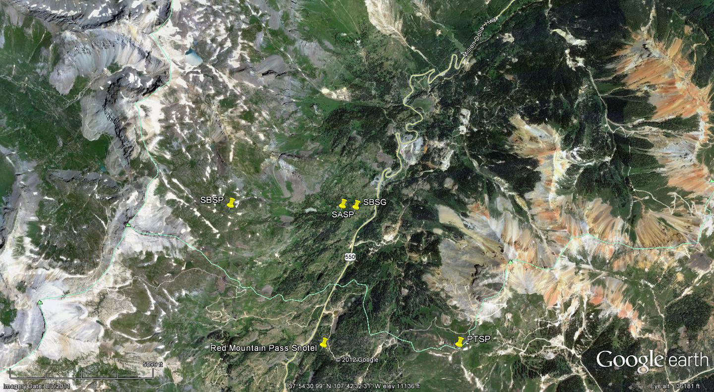
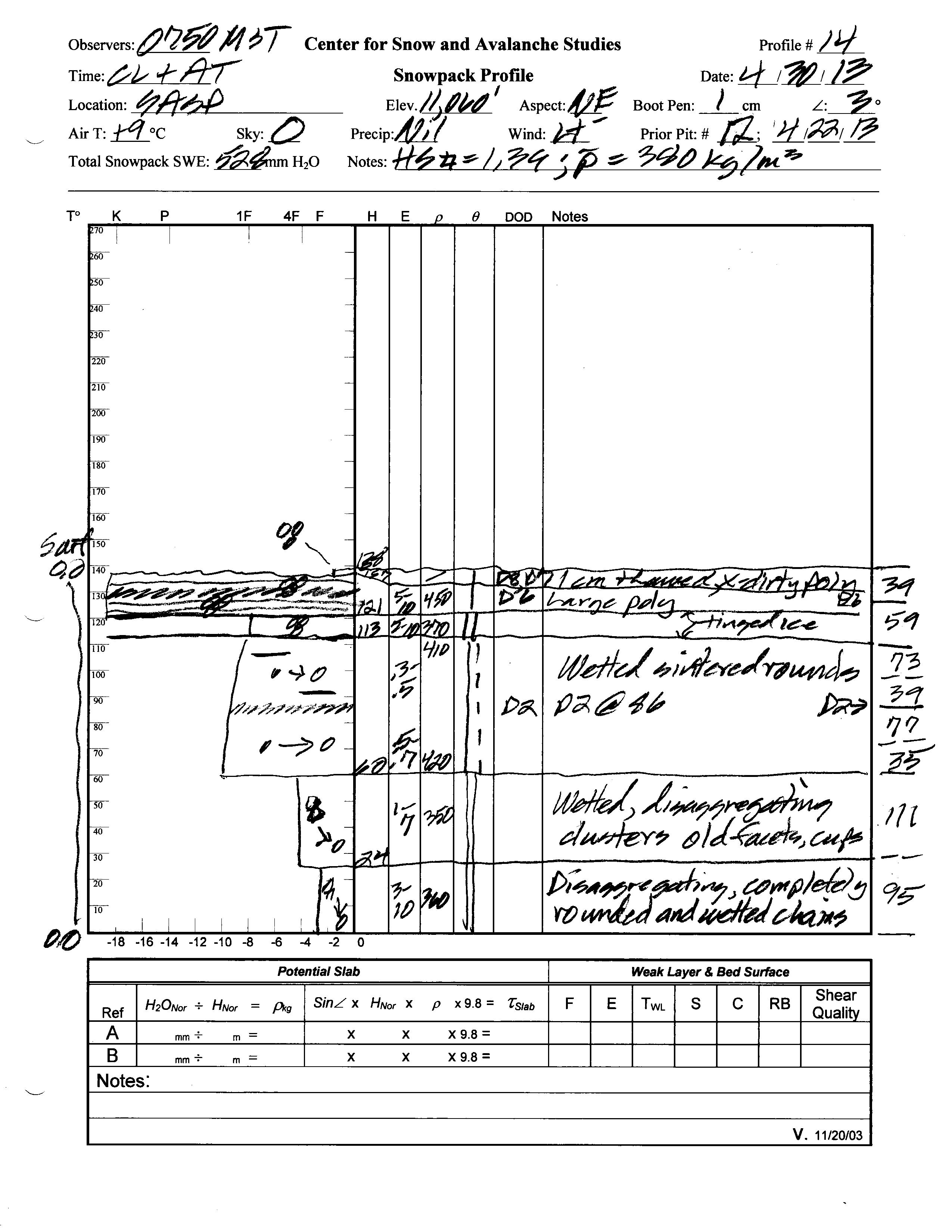
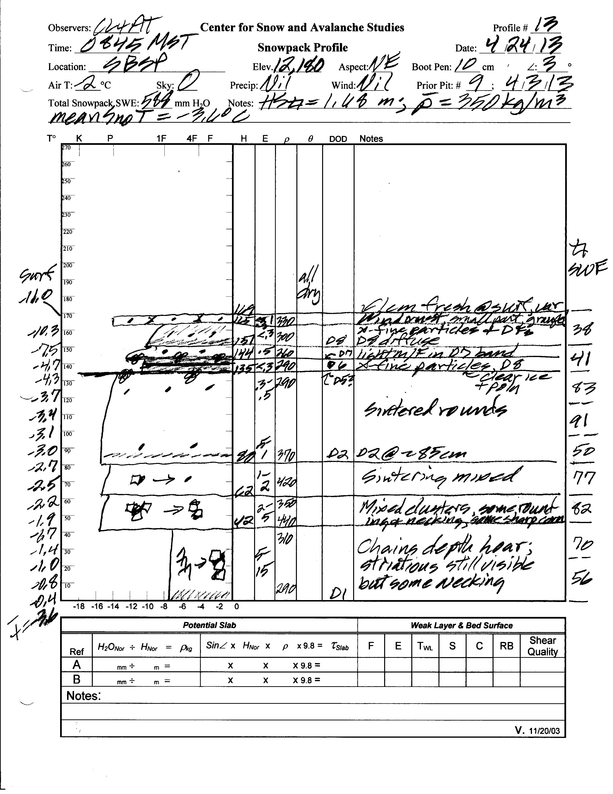
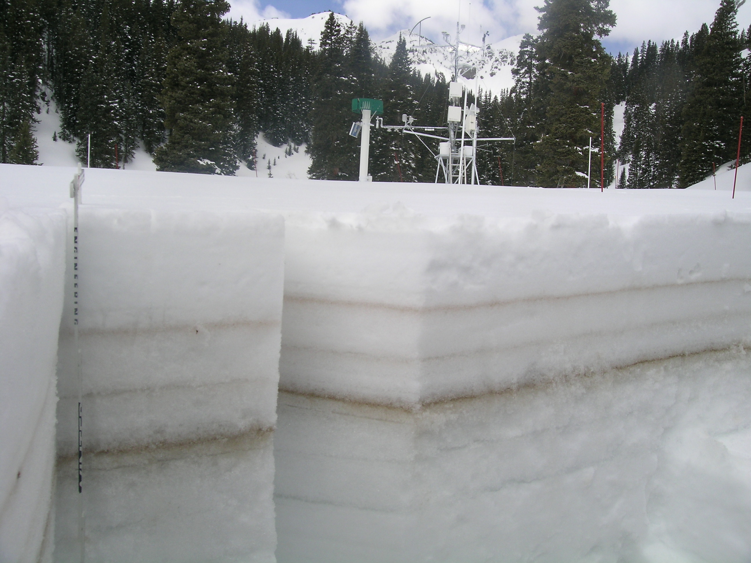
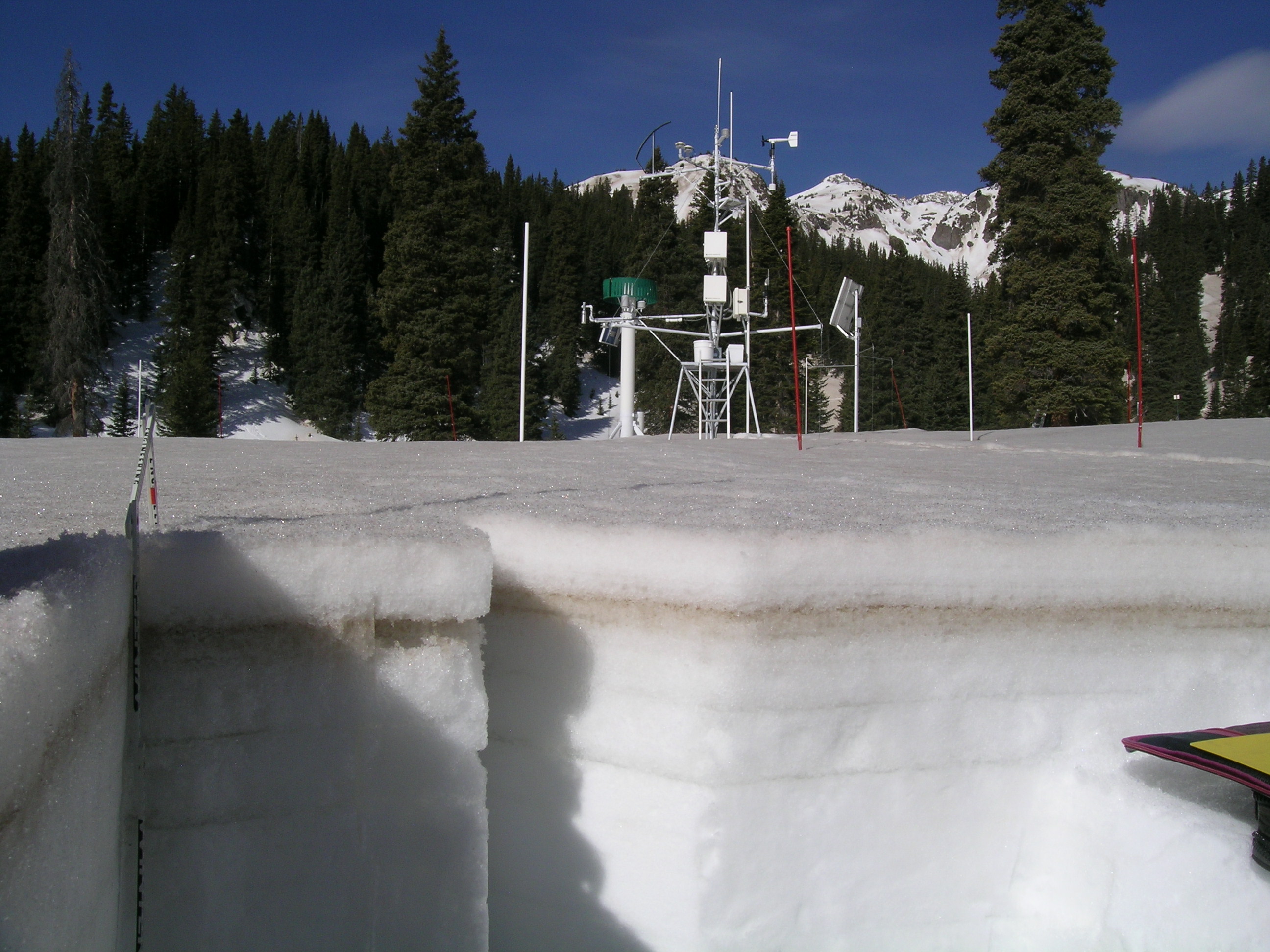
Snow cover at Swamp Angel Study Plot, in the lower Senator Beck Basin Study Area at Red Mountain Pass, peaked following Storm #21 of the season (April 17-18, 2013). Snow profile #12, on April 22, found 24.6” (624 mm) of SWE at SASP, with comparatively clean snow overlying the recent D8, D7, and D6 dust layers. Eight days later, on April 30, dust layers D8 and D7 were fully exposed at SASP, and patches of D6 had also emerged, one underneath the instrument tower and in view of the downlooking radiometers. Profile #14 found 8” less snowpack depth containing 4” less SWE, and some loss of density since April 22. Dust layer D8 likely became widely exposed at SASP later that day, after our departure, and (broadband) snow albedo fell to 0.31 (31%) between 1200-1300 hrs, an extremely low value. Higher in the Basin, Profile #13 on April 24 at the Senator Beck Study Plot (SBSP) found layers D8, D7 and D6 more deeply covered by clean snow, and a still rather cold temperature profile.
Then, in the final days of the month, emergence of dust layers D8 and D7, along with a particularly warm night on April 29, produced a notably rapid warming of the snowpack at SBSP, raising the snow temperature measured 16” (40 cm) above the ground by almost 2° C in a single 24-hour period, almost to 0° C. Such rapid warming is a red-flag indicator of increased avalanche danger in the previously ‘cold’ alpine snowcover and also signals the rapid onset of isothermal alpine snowcover conditions. By mid-day April 30, (broadband) snow albedo at SBSP had fallen to 0.60 (60%) with the initial emergence of dust layers D8 and D7; D6 had not yet reached the surface at that elevation. Nonetheless, snowmelt has now begun in that higher terrain, progressing by elevation and aspect, ablating the snowcover and contributing to basin discharge.
| Swamp Angel April 22, 2013 Snow Profile | Swamp Angel April 30, 2013 Snow Profile | Senator Beck April 24, 2013 Snow Profile |
 |
 |
 |
 |
 |
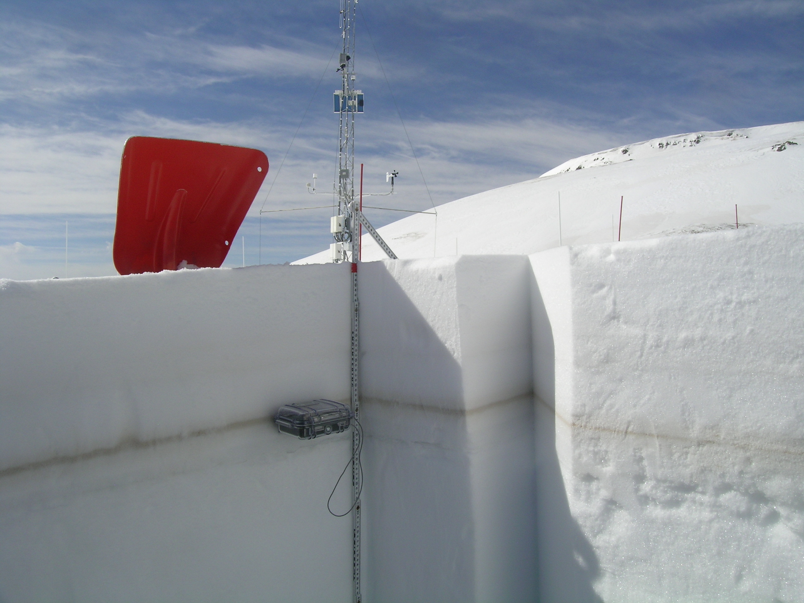 |
| Swamp Angel April 22, 2013 Pit | Swamp Angel April 30, 2013 Pit | Senator Beck April 24, 2013 Pit |

South-facing terrain near Red Mountain Pass, April 30, 2013
Melt Rate
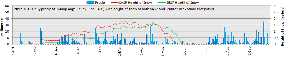
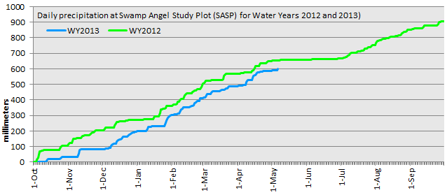
As noted above, Senator Beck Basin produced its first significant surge of snowmelt discharge in late April, as dust layers D8, D7 and, in places, D6 emerged and merged at the snowpack surface. The “Height of Snow” graph below shows loss of snowcover depth at SASP. Although snowmelt was delayed this spring, compared to spring 2012, the very rapid loss of snowpack in late April matched the rate of snowmelt observed in spring 2012. At the nearby Red Mountain Pass Snotel, Water Year 2013 peak SWE exceeded that of WY 2012, albeit still within the lower quartile of values in the period of record, and occurred slightly later than the 1971-2000 mean date. However, forced by the extremely heavy merged dust layers D8/D7/D6, melt rates sharply accelerated in late April. Unless snow albedo is substantially restored to a higher level by spring snowfalls, “snow all gone” (SAG) at the Red Mountain Pass Snotel may match the earliest dates in the period of record.
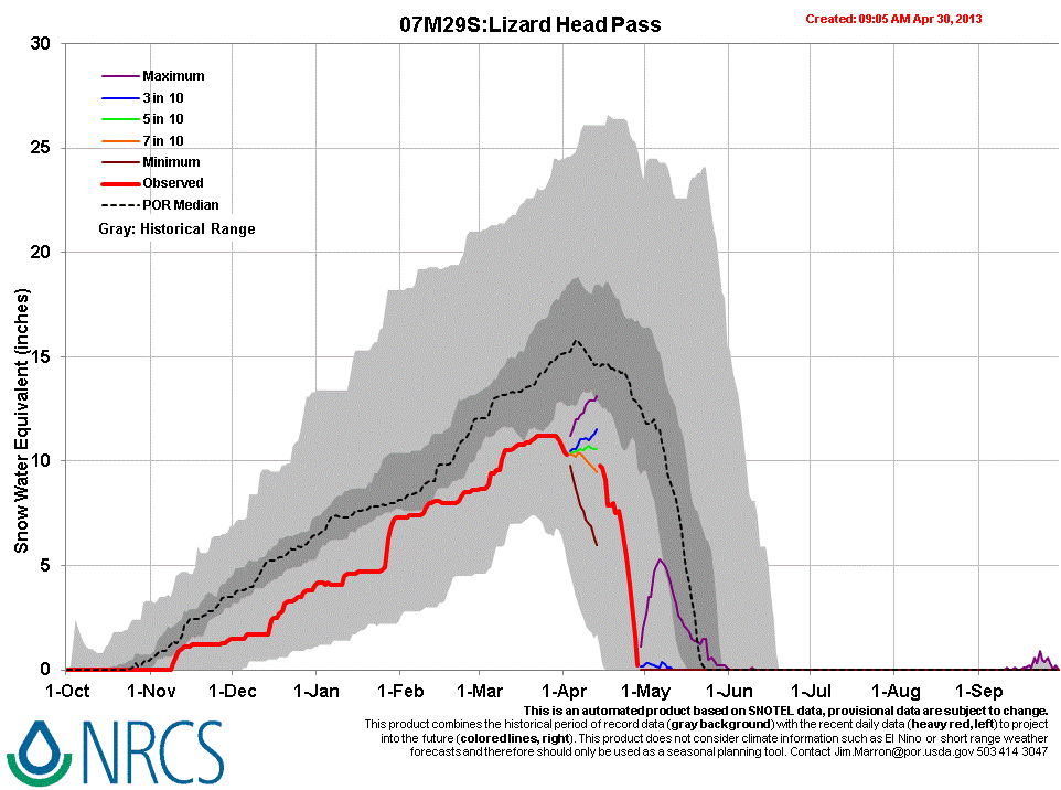
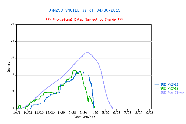
Farther south and west, the Lizard Head Pass Snotel has already experienced the full effects of merged D8/D7/D6 and reached SAG, losing 10” of SWE in 15 days in late April. (A large gap in the Snotel data may have contained Peak SWE at that site, since we received two significant winter storms during period.)


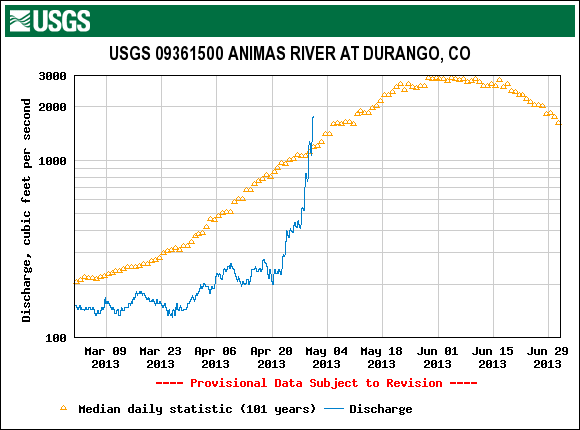
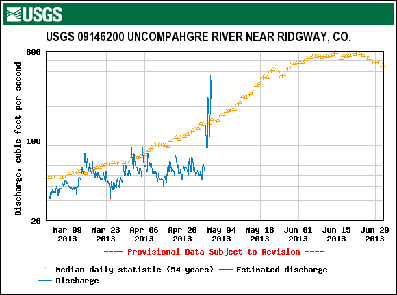
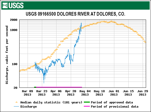
Stream Flow
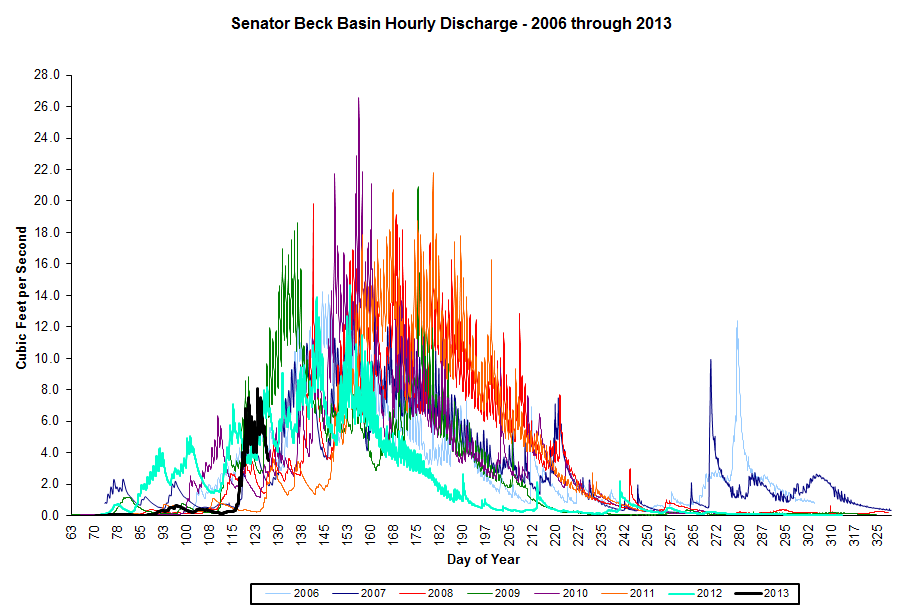
Senator Beck Basin (SBB) stream flow surged during the final days of April 2013 at a rate comparable to the initial surging of spring 2009. However, cumulative SBB discharge is still well behind spring 2012, and most other years, given the slow start to Water Year 2013 runoff. The rapid acceleration of runoff at SBB in the final days of April, as D8/D7/D6 rapidly emerged, was amplified on stream gauges lower on the Uncompahgre and in other nearby watersheds. All of those gauges were reporting much below-average discharge just before surging to or above median flow levels. Discharge on the Animas at Durango and Uncompahgre near Ridgway surged nearly ten-fold within days, and the Dolores nearly matched its median peak flow level, several weeks earlier than average. (As expected, those surges in streamflows were stalled, or even reversed, by a subsequent change in weather, with reduced solar inputs and much colder overnight temperatures.)


Wind Behavior
The following graphs show wind behavior during the Water Year 2013 dust-on-snow events at our Putney Study Plot (best wind data for Senator Beck Basin Study Area and Red Mountain Pass). We have estimated beginning and end times of each event based on observations from Silverton, CO. For more on this wind analysis, see the CODOS dust log and wind rose table. For comparison, windroses from last season are also posted. WY 2013 has produced two wind and dust storms from the WNW – events D4 and D5. Although the Putney Study Plot location minimizes the influence of local terrain on wind speed and direction, it is plausible that a terrain feature to the due west of the tower, a gentle ridge, is ‘splitting’ and redirecting due west winds into WSW and/or WNW vector(s) at the Putney site. The low frequency of due W winds in our period of record wind rose, adjoined by frequent WNW and WSW fractions of total wind, is the primary evidence of that potential effect.
D1: Nov 9, 2012 |
D2: Feb 8-9, 2013 |
D3: March 5-8, 2013 |
 |
 |
 |
D4: March 17-18, 2013 |
D5: March 21-22, 2013 |
D6: April 8, 2013 |
 |
 |
 |
D7: April 13-14, 2013 |
D8: April 15-17, 2013 |
D9: April 30, 2013 |
 |
 |
 |
Forecast
As of this writing, Thursday, May 2, 2013 the National Weather Service expects clear, sunny skies and no chance of precipitation today and Friday, here in the western San Juan Mountains. This return to maximum potential solar inputs, along with warming temperatures (especially overnight low temperatures) will enable a resumption of higher melt rates and streamflows. However, this return of the sun will be brief and may not result in a full restoration of the late April discharge rates. This weekend, increasing chances for afternoon snow/rain showers could reduce solar insolation to the snowcover somewhat, but NWS still expects partly sunny conditions and a continued slow rise in air temperatures (including overnight low temperatures). No significant accumulations of snow are anticipated; spring rains on snow always enhance snowmelt. Next week, atmospheric “blocking” to our east may result in a period of prolonged, unsettled weather for western Colorado, perhaps also resulting in reduced solar inputs to the snowpack.