CODOS Update - March 1, 2013 Conditions at Senator Beck Basin
Summary | Dust Events | Weather | Snowpack | Climate & Forecasts
Early spring greetings from Silverton, as March makes its entry here in the western San Juan Mountains. Silverton experienced a 41 degree warming trend in low temperatures in the span of two days, from a low of -19° F on the morning of February 28th, to a low of +22° F on the morning of March 1st. The local consensus is that we had a cold February, so the change is welcome. The beginning of March 2013 also signals the transition to another “dust-on-snow season”, based on our history of observation. This Update describes our Water Year 2013 winter weather to date and our dust conditions and snowpack “state” at Senator Beck Basin, as of March 1.
WY 2013 Dust-on-Snow Events
As prior Updates and Alerts have explained, we’ve logged only two dust-on-snow events so far this winter here at the Senator Beck Basin study area at Red Mountain Pass, the first of which (November 9) is buried at the very base of the snowpack, if still present at all, and the second of which (February 8) seems to have been confined to the western San Juan Mountains and Grand Mesa. Combined, these two events have delivered 2.7 grams of dust per square meter to our Swamp Angel Study Plot snowpack, in two virtually equal loading events. As Table 1 below shows, two dust-on-snow events as of the end of February is neither a high nor a low total.
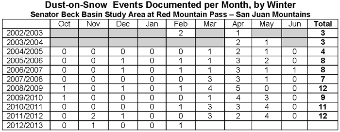
Table 1: period of record dust-on-snow event log for Senator Beck Basin Study Area. Grey shading indicates uncertainty regarding missed observations of very weak events, as detection skill developed. For a detailed listing of event dates, and for wind rose depictions of wind speed and direction at the Putney Study Plot during dust events, see: https://snowstudies.org/CODOS/dustlog.html
WY 2013 Weather
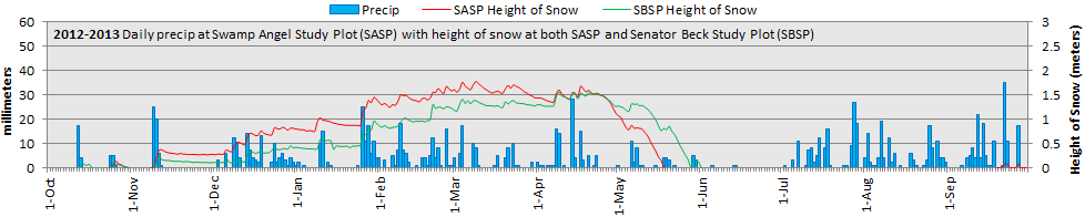
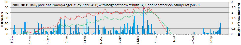
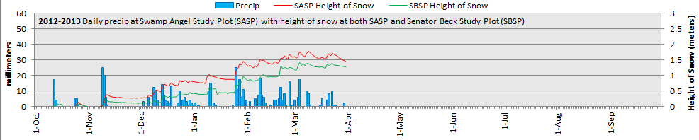
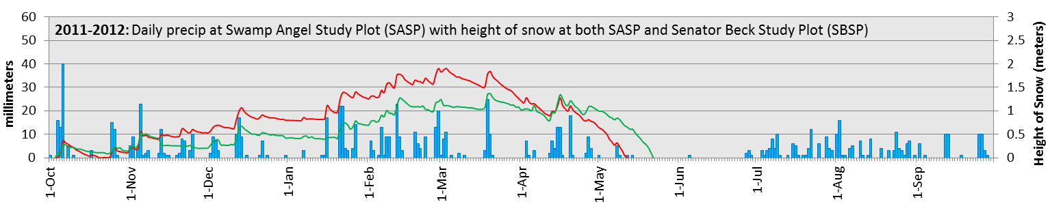
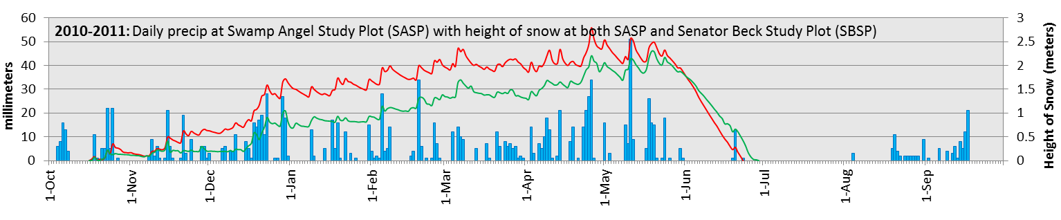
Of greater concern, here and throughout the state, is our second ‘dry’ winter in a row. Presented below are three charts showing daily precipitation and snowpack formation and ablation at Senator Beck Basin for Water Years 2011, 2012, and 2013 in progress. In short, our WY 2013 total precipitation through February 28th of 411 mm (16.18”) is actually lagging behind last winter’s total through February (through February 29th) of 504 mm (19.84”). In part, this difference may be explained by a lower number of winter storms, defined as weather events delivering at least 12 mm (0.5”) of total precipitation with no break in measured precipitation greater than 12 hours. So far in WY 2013 we’ve logged only 15 storms, versus 18 storms by the end of February 2012. Those 15 winter storms to-date in WY 2013 have also averaged only 20 mm (0.79”) of water content, versus our Swamp Angel Study Plot period of record average of 27 mm (1.06”) of water equivalent per winter storm.
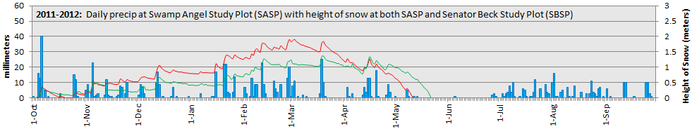
Our period of record for precipitation measurements at Swamp Angel Study Plot is comparatively short. The following graph puts the data shown above within that context, showing Water Year cumulative precipitation at the end of each month. Water Year 2013 continues to lag behind WY 2012. The extremely dry spring of 2012 is apparent in the virtually ‘flat’ trace of cumulative precipitation at the end of May and June, after comparatively poor March and April gains.
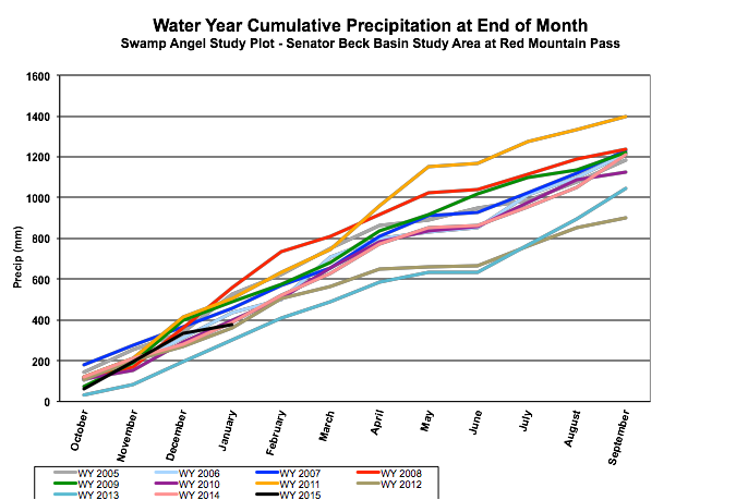
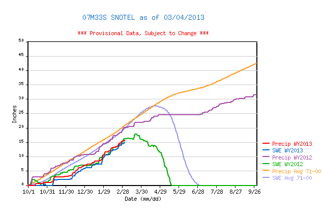
Given the small sample size, no mean or median statistics are calculated in the plot above. However, a central tendency does appear to be emerging in these Swamp Angel Study Plot precipitation data. Comparisons to data from the nearby Red Mountain Pass Snotel, 1.5 km to the south of Swamp Angel Study Plot, confirms that even this short period of record at Swamp Angel Study Plot has captured what were comparatively rare wet (WY 2011) and dry (WY 2012) winters in the longer Snotel record. The Red Mountain Pass Snotel plot below also shows WY 2013 precipitation lagging behind WY 2012 precipitation.
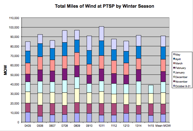
Our low winter 2012/2013 storm count may also be reflected in wind data from the Putney Study Plot. As in years past, in addition to plotting “wind rose” charts for individual winter storms and dust-on-snow events, we are also posting graphs of winter season “miles of wind” at that site, totalizing hourly average wind speeds (1 hour averaging 60 mph = 60 miles of wind), by month (below). As in precipitation, this winter is lagging somewhat behind the winters of 2010/2011 and 2011/2012 in this rough metric of wind behavior. However, spring is often the windiest portion of a given winter season.
WY 2013 Snowpack
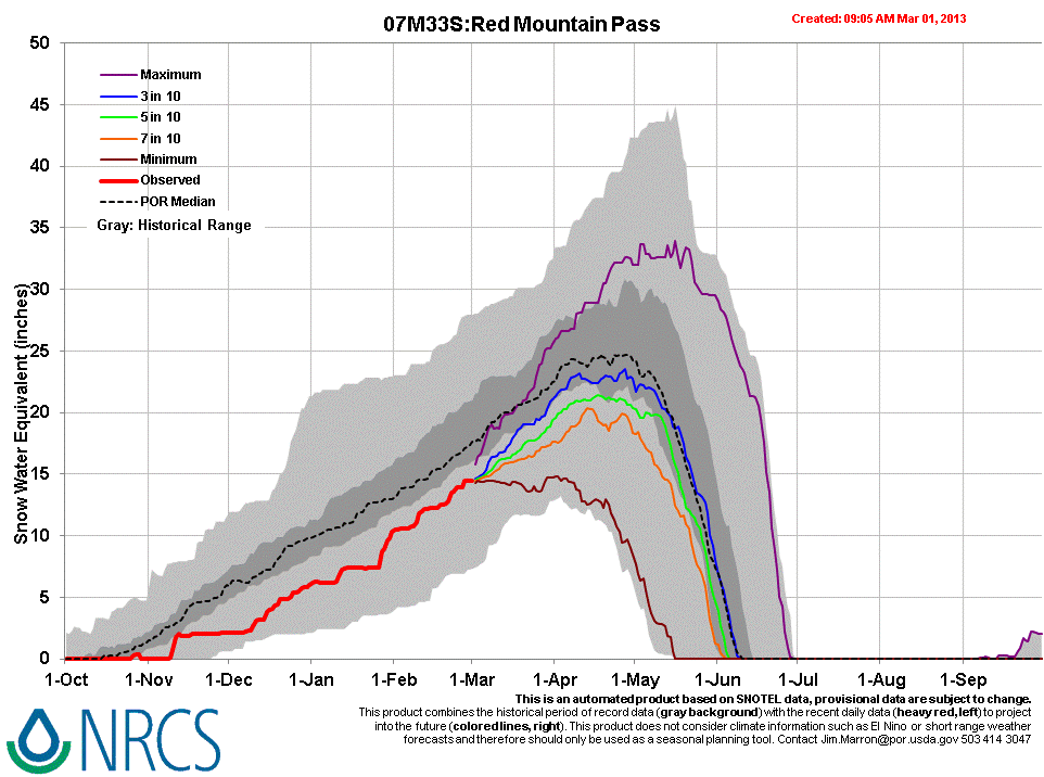
The Red Mountain Pass Snotel data plot shown above references a “SWE average [mean] 1971-2000” statistic, but other Snotel program products refer to median SWE data for the period of record. As of this writing, the Red Mountain Pass Snotel is reporting 60% of the median value for peak SWE at that site, at 14.7” SWE (as of March 3, 2013). The following “projection” product from NRCS shows this year’s SWE in the context of the site’s entire period of record range of SWE values, and shows a median trace. Several projections are presented for the remainder of the winter. Notably, these projections suggest only a 3 in 10 chance that peak SWE will exceed the lowest quartile of values in the period of record at Red Mountain Pass.
On Friday, March 1st, we conducted a formal snow profile at the Swamp Angel Study Plot, in sunny but breezy conditions. Photographs of that profile and our profile a year earlier, on March 5, 2012, appear very similar, although Friday’s pit contained a prominent dust layer mid-pack (event D2 – WY2013).
 |
 |
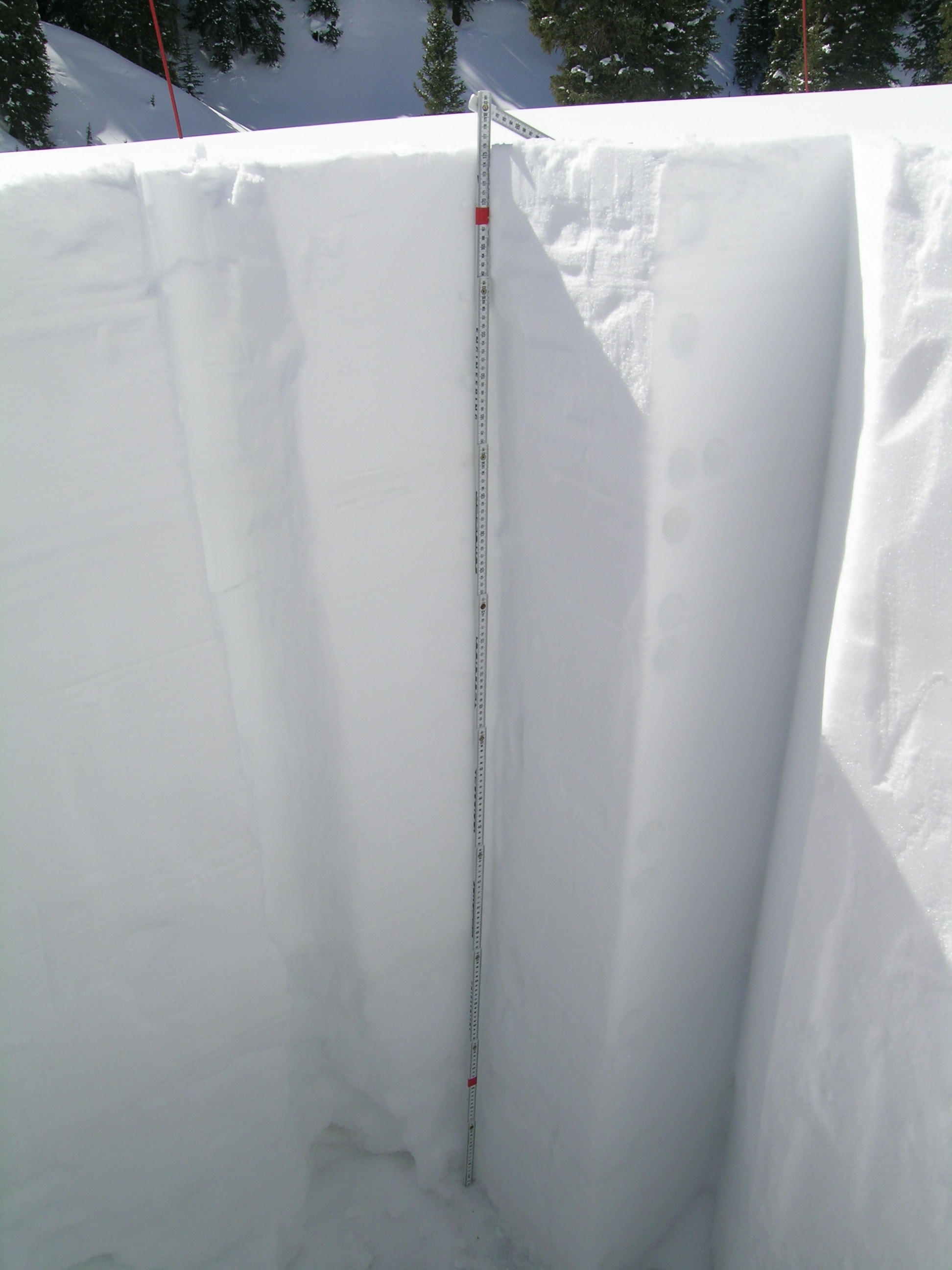
Snowpit at Swamp Angel Study Plot, March 5, 2012. Only one, very minor dust layer was present, just above the ground surface. |
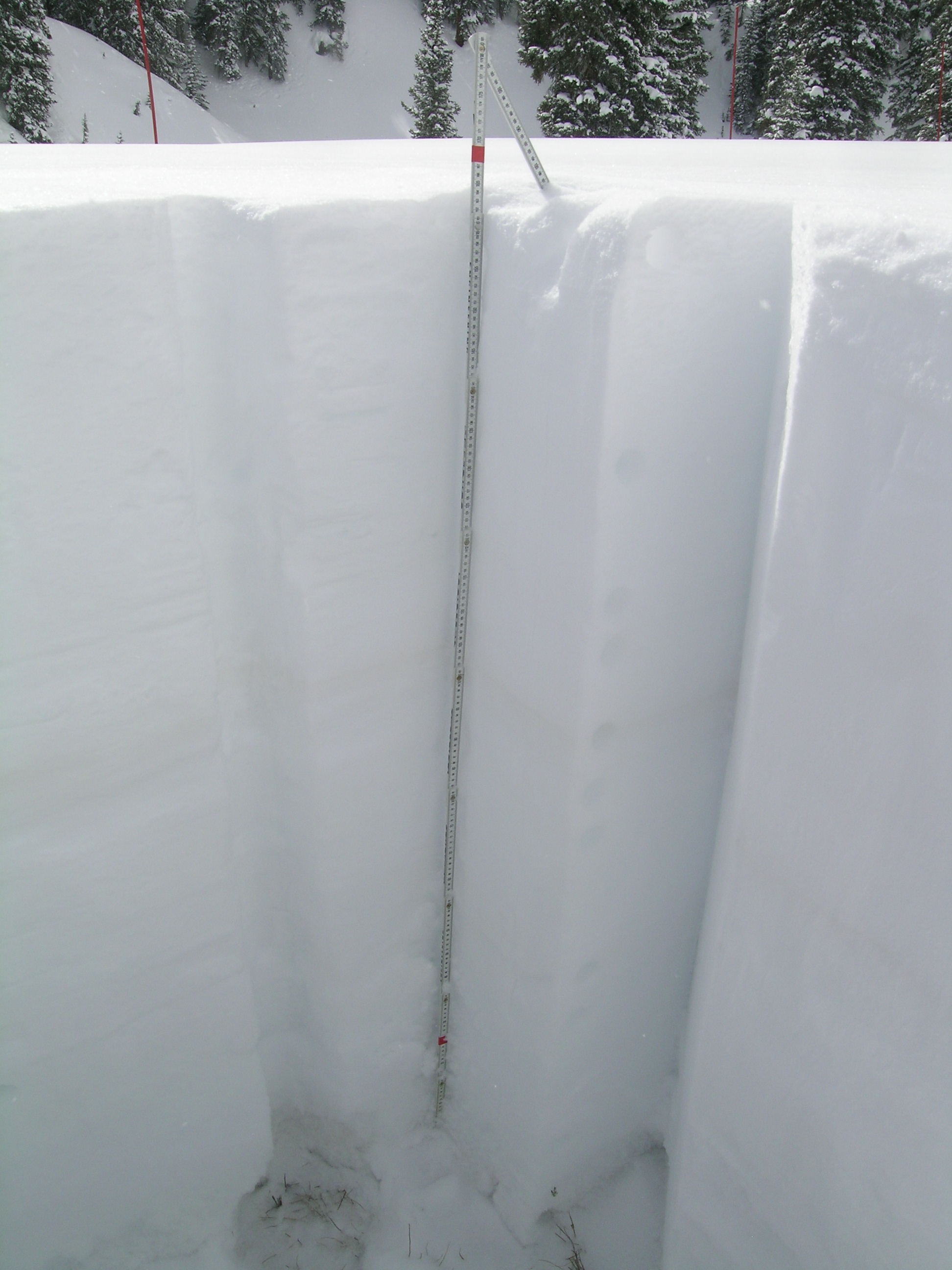
Snowpit at Swamp Angel Study Plot March 1, 2013. Dust layer D1-WY 2013 was still clearly evident just above the ground, and layer D2 is seen near the middle of the snowpack. |
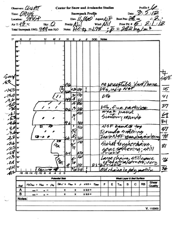
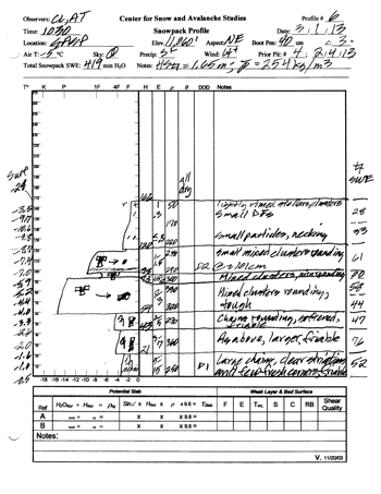
Data from the two formal snow profiles reveal the differences in precipitation discussed above. Depth, mean density, and SWE are all lower in last Friday’s pit than in early March 2012, although overall snowpack structure was very similar in both years. Snow temperature profiles in both pits showed considerable “cold content” and snow structure showed almost no evidence of melt/freeze episodes to-date. (Note that Swamp Angel Study Plot often presents marginally higher SWE values than the nearby Red Mountain Pass Snotel site, likely the effect of orographic precipitation on the north side of Red Mountain Pass).
 |
 |
Profile #6 - WY 2012 at Swamp Angel Study Plot, March 5, 2012. Total depth was 1.76 meters (69”); total SWE was 494 mm (19.45”); mean snowpack density was 282 kg/m3 (28.2% water content). |
Profile #6 - WY 2013 at Swamp Angel Study Plot, March 1, 2013. Total depth was 1.66 meters (65”); total SWE was 419 mm (16.50”); mean snowpack density was 254 kg/m3 (25.4% water content). |
As is evident from these ‘side view’ profiles of layering at this neutral aspect (near-level), sub-alpine location, snowpack structure this winter is quite poor, just as was the case in March 2012, with a weak foundation of large, angular depth hoar grain layers overlain by a stronger, mid-pack slab. This persistent weak layer structure has resulted in prolonged “Considerable” avalanche danger in the Red Mountain Pass locale, curtailing our travel to our alpine Senator Beck Study Plot. Natural and human triggered avalanches continue to plague this area, and other ranges throughout the state, and we’ve observed numerous large natural avalanches in Senator Beck Basin this winter (link here to ‘off-page’ photo and caption below).
Climate and Weather Forecasts
As discussed in our WY 2012 CODOS season summary reports, a rapid switch in the Arctic Oscillation from its negative phase to a positive state in March 2012 contributed to a very dry end to last winter in Colorado. Substantial dust loading and reduced snow albedo conditions in March, April and early May corresponded with that absence of precipitation and “forced” more rapid ablation of already sub-par snowcover to very early dates of “snow all gone” at Senator Beck Basin and throughout the state. The Arctic Oscillation index currently remains negative but may trend toward a neutral or incipient positive phase later this spring, according to the most recent National Weather Service Climate Prediction Center’s ensemble forecast. According to the CPC’s February 25, 2013 Update, ENSO (El Nino Southern Oscillation) is in a neutral condition at present and is likely to remain neutral through the spring and into Fall 2013.
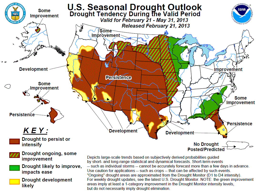
Climatologically, the February 21 through May 31, 2013 Season Drought Outlook from the Climate Prediction Center has removed their prior forecast for “some improvement” for the southern Colorado Plateau and, instead, has restored “persistence” status to that major dust source region. Further, CPC now anticipates likely “development” of drought conditions in the Mogollon Rim during the remainder of the winter. A tendency to “Persistence” is also predicted throughout the remainder of the Southern Rocky Mountain states, through May.
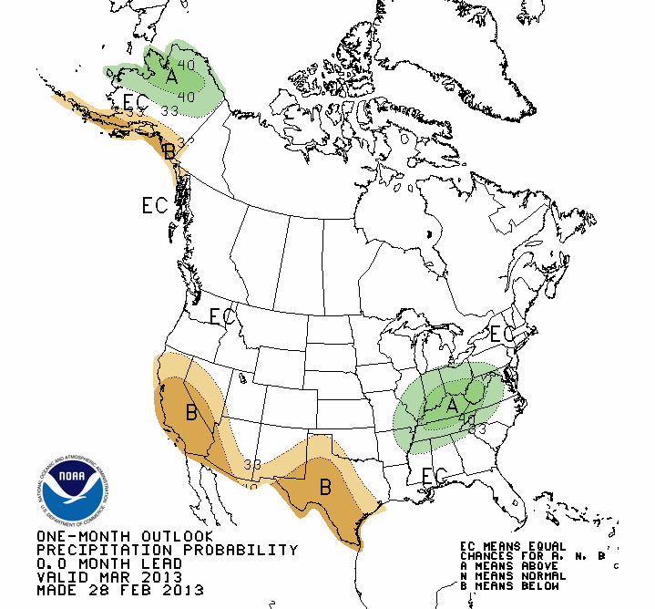
In the shorter term, the Climate Prediction Center’s projection for precipitation probability in March 2013 places Colorado, and the Colorado Plateau, in the “Equal Chances” category.
As of this writing, Sunday morning (March 3rd), a new winter storm is approaching Colorado and clouds are lowering over the La Sal Mountains near Moab (see below). A Winter Weather Advisory has been issued by the National Weather Service for up to 8-12” of new snow in our southwestern mountains and 12+” farther to the north, and rain and rain/snow mix in the lowest western Colorado valleys. The storm will include periods of significant wind from the west and west-southwest, producing blowing and drifting snow, before swinging to the northwest late in the storm. If this system produces at least 12 mm (0.5”) of precipitation at Swamp Angel Study Plot, we will log this as Storm #16 of the season at Senator Beck Basin.
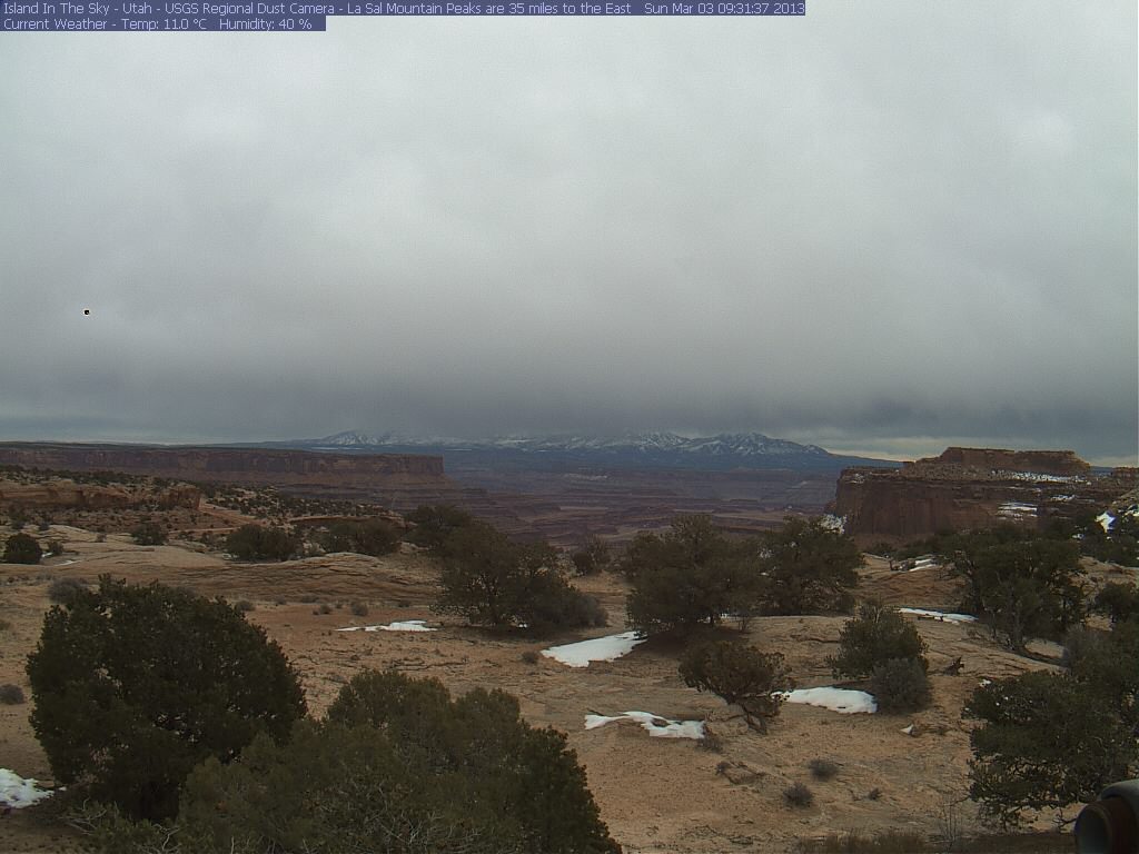
USGS Island in the Sky camera image, looking east to the La Sal Mountains, on Sunday morning, March 3rd, at 9:30 AM. Snowcover, in the foreground, was substantially reduced in recent days.
Sunny skies will follow on Tuesday (March 5th), but another storm may be developing for later in the week. The National Weather Service in Grand Junction is monitoring their suite of models for better resolution of the likely track of that system in coming days. Recent dry and sunny weather may have resulted in sufficient soil drying in Colorado Plateau dust source areas for either of these storms to mobilize and deliver new dust-on-snow events to Colorado’s mountains, so we will be closely monitoring our snowpack at Swamp Angel Study Plot.
More soon,
Chris
Chris Landry, Executive Director
clandry@snowstudies.org
Center for Snow and Avalanche Studies
PO Box 190, Silverton, CO 81433 USA
(970) 387-5080
www.snowstudies.org

