Summary of April 4-11, 2012 CODOS Circuit
The CSAS team’s recent circuit of CODOS sites, and the valleys in between, has etched the remarkably snow-free landscape into memory, in contrast to still-vivid memories of Spring 2011. Locals throughout the state nervously compare this season with the spring of 2002, or even more extreme drought in earlier decades. Even though a return to winter weather is currently adding additional snow and restoring higher snow albedo to Colorado’s mountain snowpack, the die for small and early runoff seems to be cast, and the probabilities of a late-spring recovery in snowpack water storage grow slimmer by the day, as more and more terrain becomes snow free.
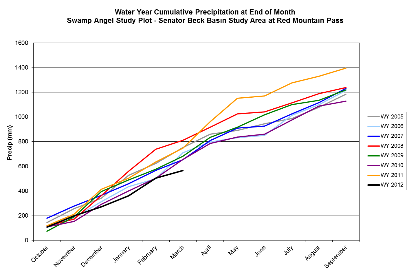
In a synchronized display throughout the state, dust-on-snow has played a role, particularly in the past six weeks. However, the fundamental driver of the shortfall in snowmelt water supplies is the simple lack of snow precipitation. The Snotel network has documented this very dry winter throughout the Colorado mountain system and others, such as the State Climatologist, will no doubt evaluate the season’s very warm air temperatures. Here at Senator Beck Basin, we’ve measured winter storms and Water Year precipitation since 2004 (see CSAS Storms and Precip Data Workbook) at our Swamp Angel Study Plot and Water Year 2012 is on track to be our driest winter to-date, as seen in the graph below. March 2012 was a particularly dry month here in the San Juan Mountains, and throughout the state, and April is also falling behind our own short period of record mean precipitation. That period of record, now into the 9th winter season, has established April as our wettest month, perhaps skewed by the relentless string of storms in April 2011.
Our Updates have discussed the severe shortfalls, statewide, in snowpack and SWE accumulation in March and early April, coincident with the deposition of several layers of Colorado Plateau (and even ‘local’) dust at the snowpack surface, also statewide, and the role of dust in warming and ‘ripening’ snowpacks to isothermal temperatures at/near 0° C. That process is largely elevation and aspect controlled, but vegetation and shading also play a major role. When the snowcover becomes isothermal, and the snowmelt energy budget is sustained and enhanced by reduced snow surface albedo in association with sunny weather, snowmelt discharge will commence and rapidly accelerate. That process began following dust event D4 in early March with the lowest elevation snowcover and has advanced to higher elevations beginning with sunny aspects and more slowly including more northerly terrain, as we’ve seen at Senator Beck Basin and throughout the state.
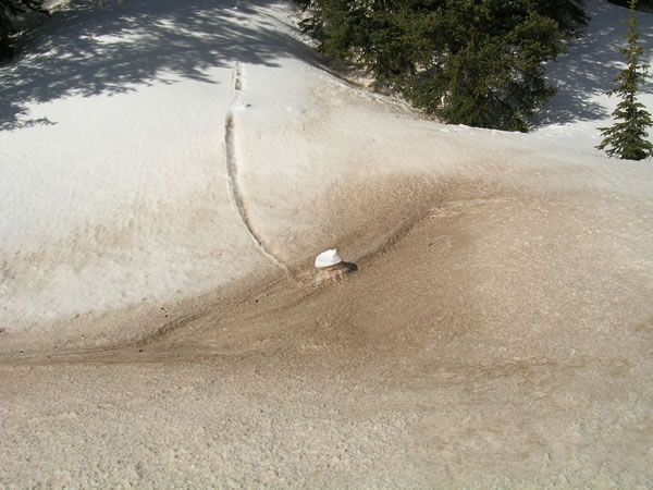
The very warm air temperatures recorded throughout March contributed to that process but, as our serendipitous observation of snowmelt processes shown in the images demonstrate, radiative forcing of the snowmelt energy budget can substantially outweigh the energy transfered to the snowpack by warm air. The first image (familiar to many of you from our CODOS presentations), taken on May 11, 2010 at our Swamp Angel Study Plot, illustrates the impact of albedo on snowmelt rates. In this case, a clean snowball of new snow (only) has rolled off a wooded slope onto a flatter meadow. That meadow had a considerable amount of dust at the snowpack surface prior to the inch or two of new snow. Within a day, radiation had penetrated through that thin layer of new snow and been absorbed into the dust, completely ablating the new snow in the meadow and continuing rapid melt of the underlying snowpack. Meanwhile, the very ‘bright’ white ball of new snow was reflecting the same radiative inputs, shielding the old snow underneath from that solar energy and leaving the snowball and old snow surface ‘super elevated’, relative to the rest of the meadow. Air temperatures around the snowball were no different than over the snow surface immediately adjacent to the snowball.
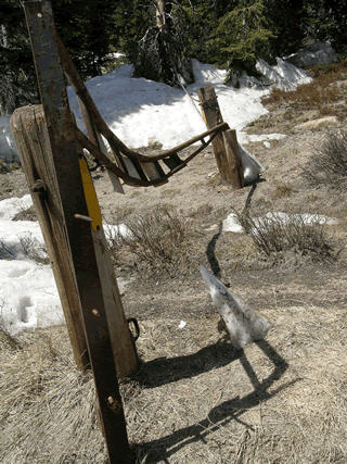
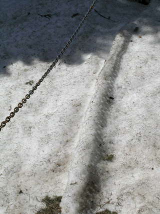
In the second case shown below, just observed during our approach to the Berthoud Summit Snotel and CODOS site on April 10th, the inverse effect of shading from radiative forcing is illustrated. Here, narrow shadows cast onto the snowpack by a metal gate and by a suspended chain have reduced direct radiative forcing of snowmelt over an extended period of time. Behind the sign, all of the snowpack has melted except the narrow fin of snow being shadowed by the gate. The fin is leaning toward the sun at the angle of incoming solar radiation (during early afternoon when trees adjoining this road are not also shading this location). Nearby, a chain suspended above the snow surface is producing a similar but reduced differential in melt rate since the shading is less complete. As was the case in the snowball example above, air temperatures can reasonably be assumed to be no different over the snowpack, from one side of these shadows to the other, during the evolution of these features.
These examples illustrate the challenge of interpreting radiative forcing effects on snowmelt rates using Snotel data, since many Snotel sites experience significant shading from adjoining trees.
Hydrographs throughout the Colorado mountains show the influence of the early onset of snowpack warming and subsequent snowmelt runoff. Although not high in absolute terms, most watersheds have experienced very high flows during March and early April, relative to normal (median) flows for a given date. Given that many Snotel sites may have recorded Peak SWE in early or mid-March (still subject to new major winter storms at some Snotels), as much as six weeks earlier than average, a substantial advance in overall snowmelt runoff timing, and in passage of center of mass, may be occurring.
Given the very extensive emergence of bare ground, at all elevations, and increasing plant activity, additional snowfalls that land on bare soil may be largely consumed by infiltration and evapotranspiration, and not reach water courses – we observed green grass at the base of and near many snowpits, and tree leafing in many locales during our circuit. At this time, it seems that only alpine terrain retaining significant snowcover would capture and store, albeit briefly, any additional SWE from winter storms. New snow falling on bare ground in alpine terrain will quickly melt.
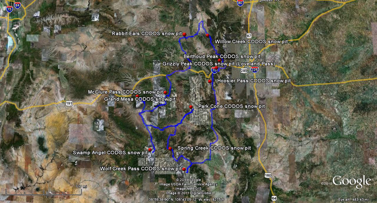
Updates by Site:
Berthoud Summit (April 10) | Grand Mesa (Apr 4) | Grizzly Peak (April 10) | Hoosier Pass (April 9)
McClure Pass (April 11) | Park Cone (April 9) | Rabbit Ears Pass (April 10) | Senator Beck Basin (Apr 7-8)
Spring Creek Pass (April 9) | Willow Creek Pass (April 10) | Wolf Creek Pass (April 9)
PDF of complete 52page Update (7.7mb)
Chris Landry, Executive Director
clandry@snowstudies.org
Center for Snow and Avalanche Studies
PO Box 190, Silverton, CO 81433 USA
(970) 387-5080
www.snowstudies.org

