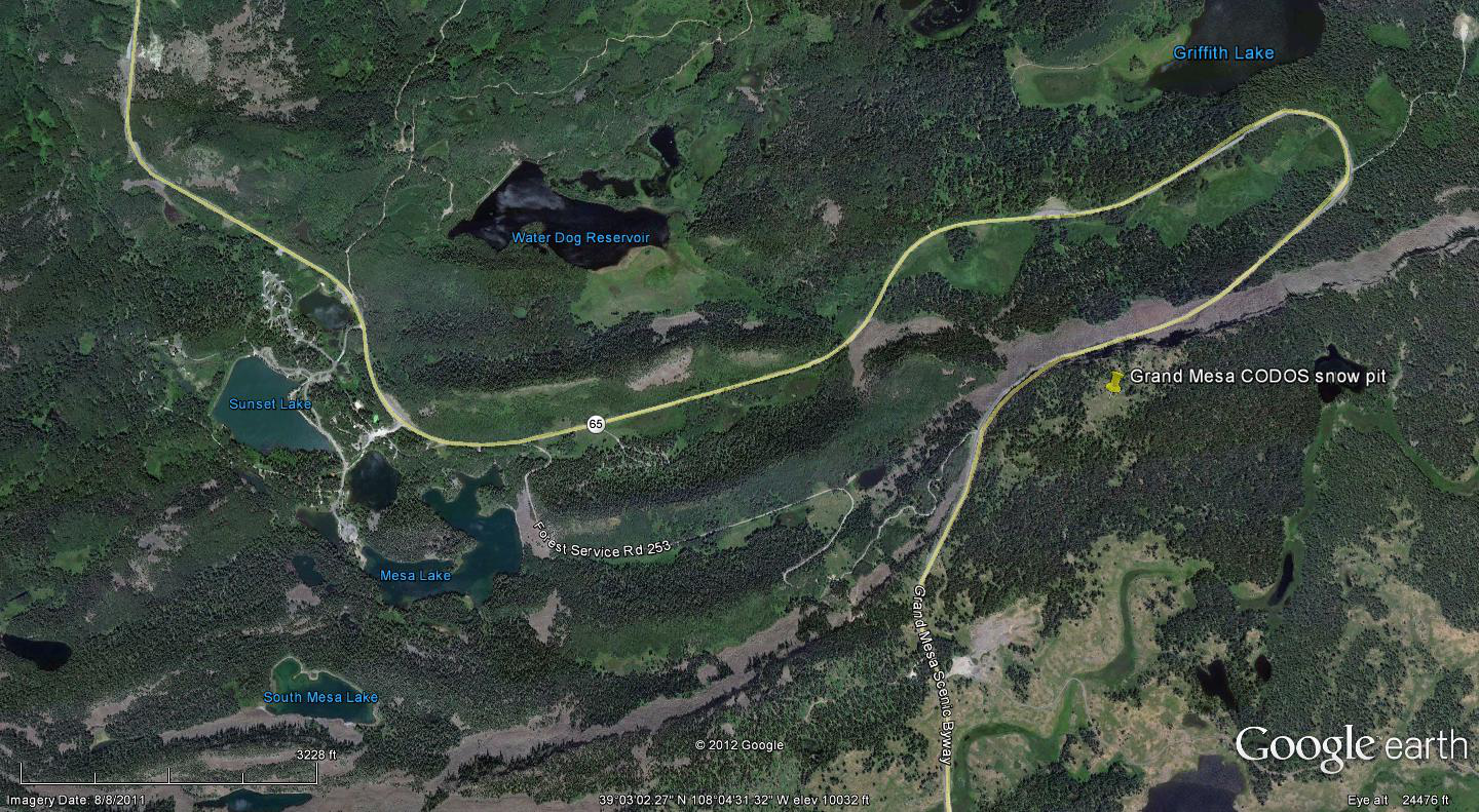
 CODOS Update for Grand Mesa site:
visited March 22, 2013
Summary | Snowpack | Melt Rate | Forecast
Summary
This field session at the Grand Mesa CODOS site, our first of the WY 2013 season, found somewhat less SWE than observed a year earlier, in slightly deeper snowcover. Surprisingly, fresh dust was not clearly observed at/in the snowpack surface despite obvious dust in the air in the Uncompahgre Valley below (event D5). However, deposition of dust layer D5 on Grand Mesa later that day is likely and two dust layers were clearly evident within the snowpack. The snowpack still retains some cold content and will require additional warming to become isothermal. Our CODOS Grand Mesa snow profile contained 5.8” more total SWE than the nearby, but lower, Mesa Lakes Snotel site was reporting that day.
SnowPack Discussion
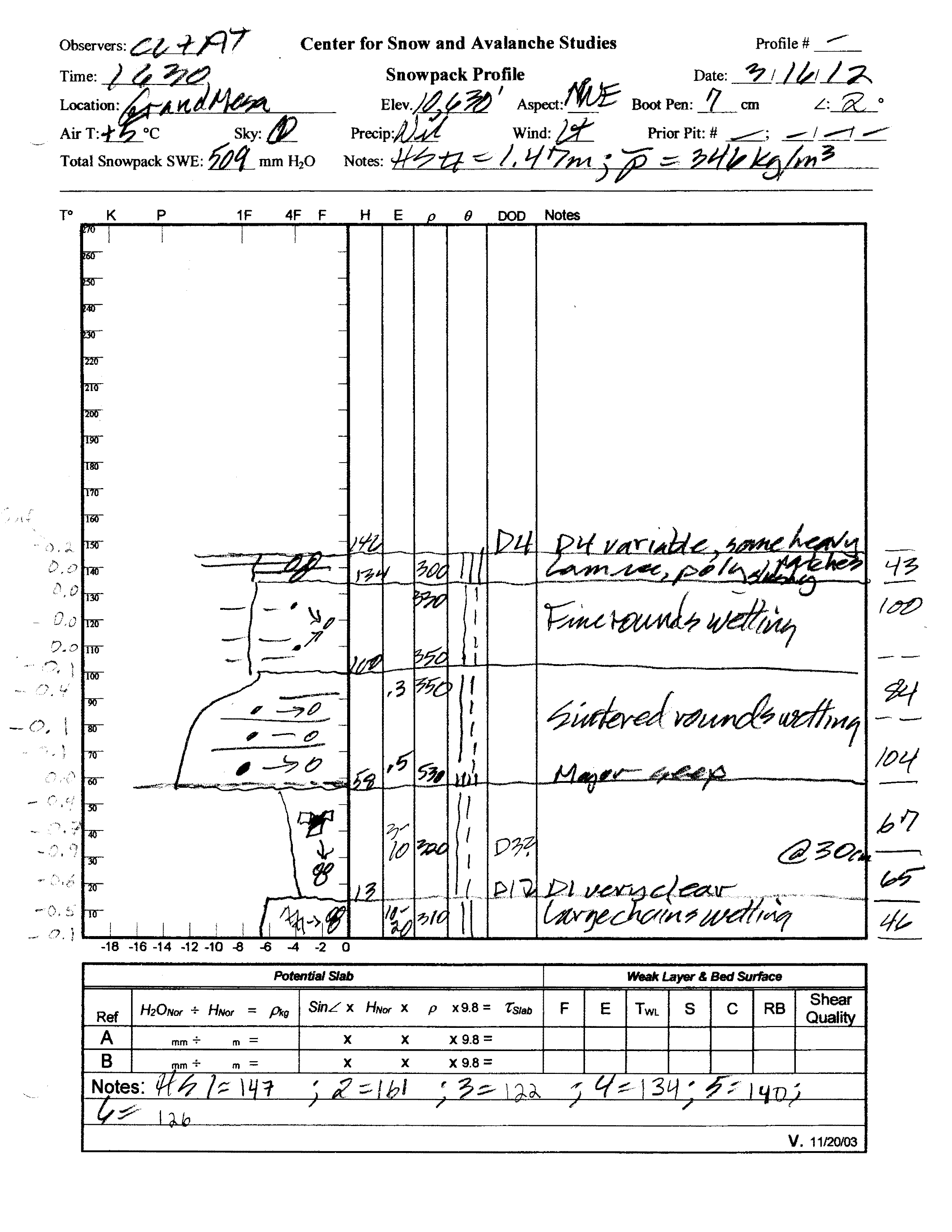
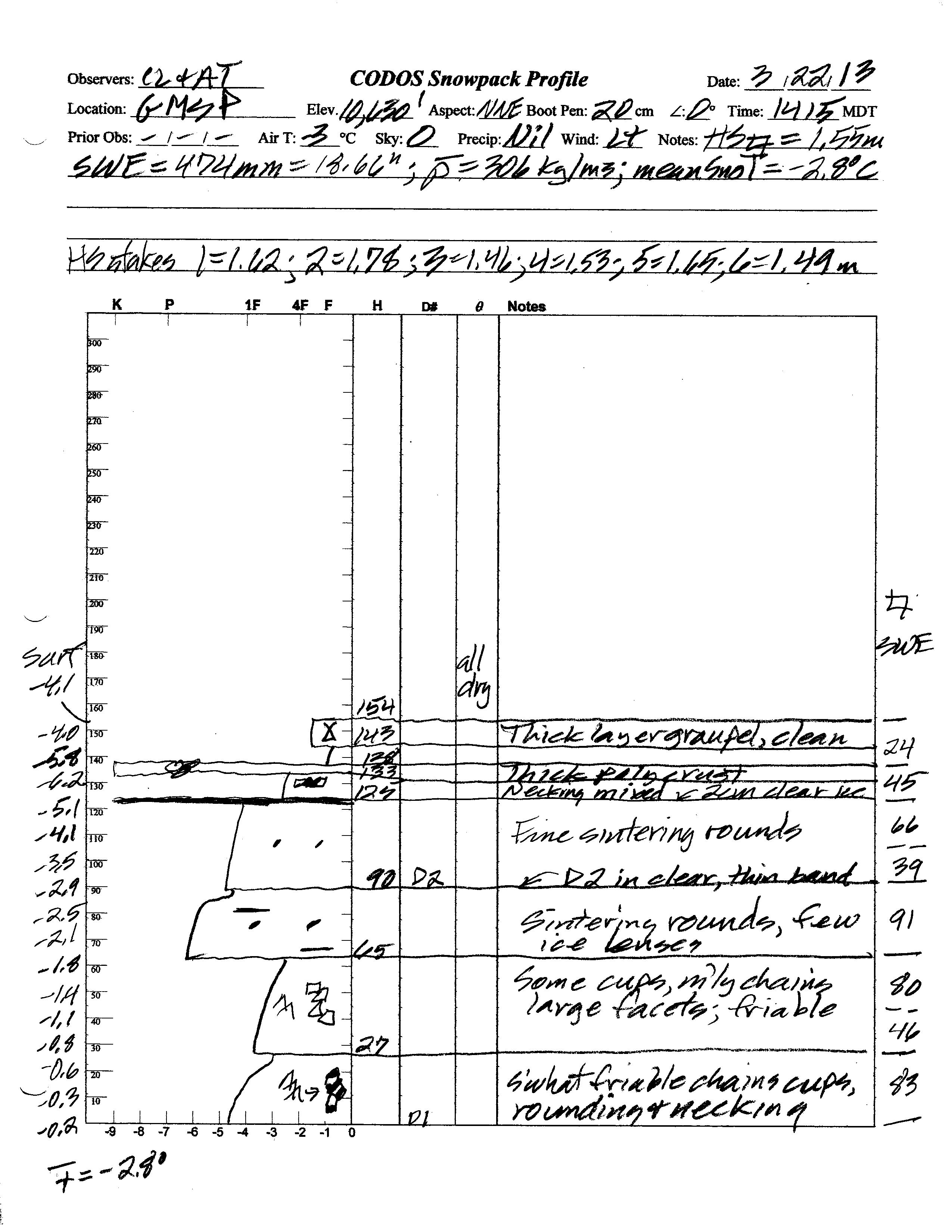
Total snow depth in our March 22, 2013 Grand Mesa CODOS site snow profile was 61”, 3” more than observed at the site a year before, on March 16, 2012. Total SWE in this profile was 18.7”, 1.4” less SWE than measured a year earlier. Mean density of this snowpack was 306 kg/m3 (30.6% water content), substantially lower than the 346 kg/m3 mean density measured a year before.
Melt-freeze episodes had occurred in the snowpack at the CODOS site earlier in March, represented by “polycrystal” crusts, clear ice layers, and ice lenses embedded in other layers. However, on March 22 the snowpack was once again completely dry and retained significant cold content. Mean snowpack temperature in this profile was -2.8° C, as compared to -0.3° C a year earlier, when the entire snowpack exhibited some degree of wetness.
Dust-on-snow layer D5-WY2013 (March 21) was not yet evident within the thin layer of new snow at the surface in our CODOS snow profile, or on the Grand Mesa at large, but deposition was very likely in progress, given the significant ambient dust observed in the air upon approaching the Grand Mesa from the Uncompahgre Valley. Two additional dust layers were clearly observed within the snowpack, corresponding to events D2 and D1. Almost 7” of overlying SWE covered the D2 (February 8) layer, so considerable snowmelt will be required to expose layer D2. Any deposition of the D5 layer will accelerate that snowpack ablation and expose D2 more quickly.
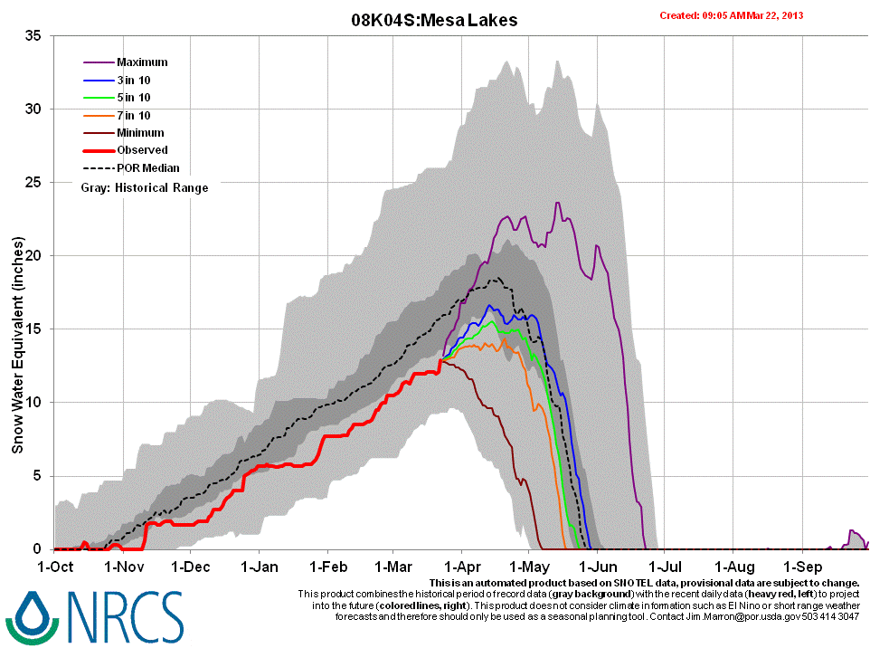
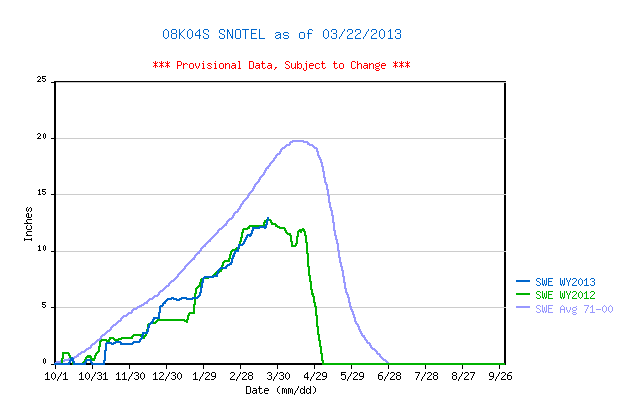
Mesa Lakes Snotel data places current SWE near the top of the lower quartile of SWE values for the period of record and very close to the same-date value recorded in WY 2012, well below the 1971-2000 mean for that site.


Melt Rate
The Mesa Lakes Snotel site continues to accumulate SWE and reports no significant losses of SWE, to-date. Episodes of surface snowmelt had occurred in the snowpack at the higher, slightly northeast-facing CODOS snow profile site but we observed no indications that free water had yet percolated to the bottom of and exited the snowpack, as runoff. Upon renewed surface melt conditions in coming days, cold snow temperatures within the snowpack will still refreeze percolating free water, as ice layers and “flow fingers”. Nonetheless, that process, enhanced by a presumed dust layer D5 (and eventually by the merger of D5 with D2), will consume cold content and accelerate snowpack warming. At the lowest snow covered elevations, on the sides of Grand Mesa, solar energy absorbed by D5 (perhaps already merged with D2) will result in accelerating snowmelt runoff (or absorption into soils) and snowcover ablation, to “snow all gone” (SAG).
Forecast
The National Weather Service anticipates partly-to-mostly sunny weather for the Grand Mesa for the remainder of March, with only slight chances for some snow showers, and seasonable temperatures rising to the 40’s. Given some deposition of D5 dust-on-snow layer at/near the snowpack surface, and with the minimal accumulations of new snow since our site visit, the Grand Mesa CODOS site may already be experiencing some reduction in snow albedo and additional, dust-enhanced absorption of solar energy. Initially, that extra increment of absorbed solar energy will accelerate snowpack warming, as infiltrating melt water forces the snowpack toward isothermal temperatures, at 0° C throughout. Once isothermal, and as/when layers D5 and D2 merge and remain exposed, snowmelt runoff (or absorption by soils) will commence and snowpack ablation will accelerate. Those snowmelt processes are more advanced, in much thinner snowcover, at the lowest snowcovered elevations on the flanks for the Grand Mesa.
As of March 23, 2013 only NRCS’s “maximum” projection of future snowpack accumulation would result in peak SWE at/above the median at the Mesa Lakes Snotel site. NRCS projects between a 3 in 10 chance and a 5 in 10 chance that complete snowcover ablation (snow all gone, or SAG) will occur near the median date at that site, but higher probabilities that SAG will be earlier than the median date. Those projections are made based on historical snowpack behavior but without direct, season-specific estimations of dust enhanced snowmelt rates.