CODOS 2012 Reports
With direct funding support from stakeholders, CODOS monitors the presence/absence of dust layers at 11 mountain pass locations throughout Colorado. With those data, data from nearby Snotel sites, and weather forecasts, CODOS provides its funders with a series of “Update” analyses of how dust-on-snow is likely to influence snowmelt timing and rates during the snowmelt runoff season.
Current funders receive timely updates throughout the snowmelt season. Please contact Chris Landry if your agency/organization is interested in joining the CODOS stakeholders.
2012 Summary: 2012 Season Summary
Berthoud Summit: 2012 Season Summary | May 2 | April 10 | March 28 | March 15
Grand Mesa: 2012 Season Summary | May 1 | April 5 | March 28 | March 16
Grizzly Peak: 2012 Season Summary | April 27 | April 10 | March 28 | March 15
Hoosier Pass: 2012 Season Summary | May 2 | April 9 | March 28 | March 14
McClure Pass: 2012 Season Summary | April 27 | April 11 | March 28 | March 16
Park Cone: 2012 Season Summary | April 27 April 9 | March 28 | March 14
Rabbit Ears Pass: 2012 Season Summary | May 2 | April 10 | March 28 | March 15
Senator Beck Basin: 2012 Season Summary | April 23 | April 7-8 | March 26-27 | March 5-16
Spring Creek Pass: 2012 Season Summary | April 9 | March 28 | March 17
Willow Creek Pass: 2012 Season Summary | April 27 | April 10 | March 28 | March 15
Wolf Creek Pass: 2012 Season Summary | May 1 | April 9 | March 28 | March 17
Prior Year Updates:
Water Year 2012 CODOS Updates (pdf, 9.5 mb)
Water Year 2011 CODOS Updates (pdf, 5.4mb)
Water Year 2010 CODOS Updates (pdf, 5.4mb)
Water Year 2009 CODOS Updates (pdf, 2.3mb)
Water Year 2008 CODOS Updates (pdf, 0.8mb)
CODOS Sites Overview Map
. Click the map below for a larger version.
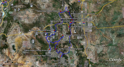
The CODOS site atlas and KMZ file are available to CODOS stakeholders upon request.


