 CODOS Update for Grizzly Peak:
April 27, 2012
Summary |
Snowpack |
Melt Rate |
Forecast |
Stream Flows |
Forecast |
Previous Update
Summary
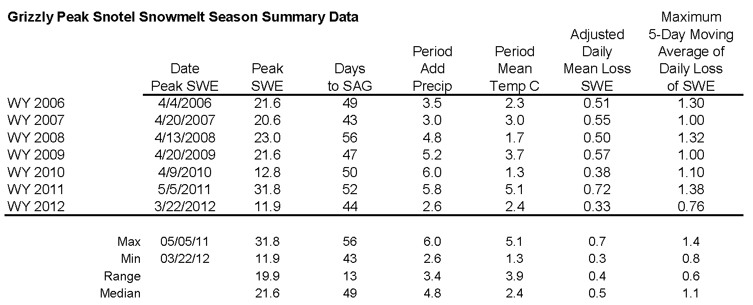
The Grizzly Peak CODOS snowpit site, on an open bench immediately adjacent to the same-named Snotel site, had reached “snow all gone” (SAG) by April 14th, just days after our April 11th site visit. Prior to SAG, all dust layers were merged at the snowpack surface. Dust concentrations and albedo reductions were somewhat less than those observed at Senator Beck Basin. After some small additions of new snow and SWE in mid-April, snowmelt at the Grizzly Peak Snotel has accelerated and is now approaching SAG.
Given the early loss of this season’s scant low elevation snowcover in Summit County watersheds, snowmelt runoff is now dependent on similarly scant snowcover remaining largely above the Snotel network, in sub-alpine and alpine terrain. As observed during our early April CODOS circuit, desert dust is present in the snowpack in this locale. Recent surging in streamflows at the nearby Snake River at Montezuma stream gauge included the influence of re-emergent dust as clean new snow deposited in mid-month was ablated by very warm and generally sunny weather. Recent unsettled, showery, and cooler weather, with some fresh snow, has not yet substantially slowed that surge in runoff. A return to sunny and dry weather will produce a more-or-less quick return to accelerating streamflows, depending on the depth of burial by clean new snow of the merged D8-D4 dust layer.
SnowPack Discussion
All snowcover is gone from the Grizzly Peak CODOS snowpit site. Our previous Grizzly Peak Update presents this season’s snow profiles and snowcover photos.
Melt Rate
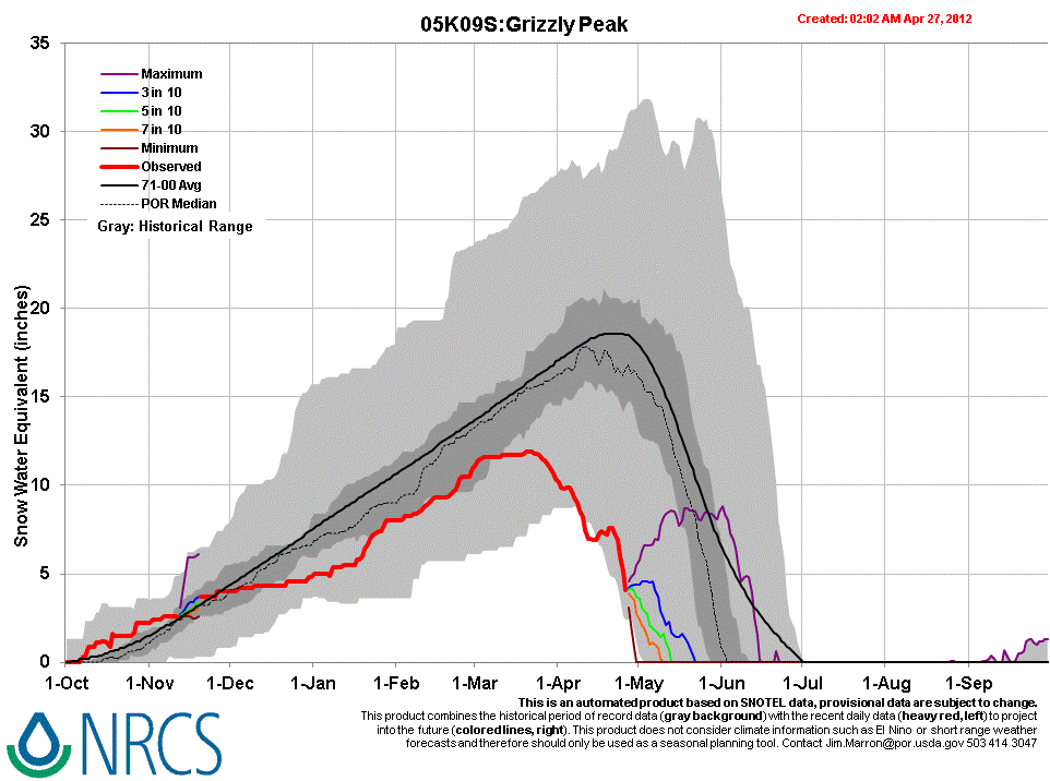
Following Peak SWE of 11.9” from March 20-22nd, moderate melt rates of 0.2-0.4” per day, and even some small gains in SWE, prevailed at the Grizzly Peak Snotel before SWE losses began to accelerate on April 21st, enhanced by the re-emergence of dust. Melt rates recently reached 1.0”/day and only some 4” of SWE remain at this Snotel site
Stream Flows
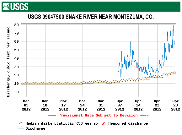
Following a modest surge in discharge ending soon after our April 11th site visit, declining local streamflows in mid-April at the USGS Snake River near Montezuma gauge corresponded with a period of unsettled, cooler weather and small snowfalls, and a restoration of higher snow albedo. Beginning on/about April 20, under a very strong high pressure regime bringing very warm and generally sunny weather, recent (clean) new snow was ablated, as the new snow thinned and solar radiation was absorbed in the dust underneath. As a result of that combination of very warm weather and reduced snow albedo, melt rates accelerated and discharge surged well above median levels.
As of this writing Friday, April 27th, that recent upward ratcheting in discharge shows little effect from the return to unsettled, cloudy, and cooler weather in the past 24 hours. The next episode of sustained sunny and dry weather will, depending on the depth of any clean new snow recently deposited on the remaining snow covered terrain, more-or-less quickly re-expose the old, low-albedo snow surface, resuming enhanced snowmelt runoff rates.
Forecast
The National Weather Service Grand Junction office expects cooler and drier air to replace scattered snow and rain showers by later today. Another comparatively dry system passes through Colorado on Sunday as near-normal temperatures return. Then, partly or mostly sunny weather brings a return to above-average temperatures under zonal, westerly flow early in the week, but with some continued chances for scattered showers. A system from the Pacific Northwest may deliver additional precipitation to northern Colorado from mid-day Tuesday into Wednesday.