Summary May 2012 CODOS Circuit
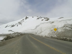
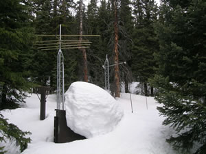
In contrast to the substantial variations that CODOS has observed and described in prior years, Water Year 2012 snowpack formation, dust deposition and emergence, and snowmelt and runoff behavior have been generally synchronized throughout the locales that CODOS is monitoring, with much less spatial and temporal variability in those processes, from north to south. Unfortunately, of course, this season’s snowpack statistics could not have been more different than WY2011, presenting extremes at both ends of the spectrum of inter-annual variability. Our just-completed circuit through the Colorado mountains certainly presented very different scenes than we observed in Spring 2011.
 |
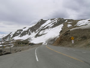 |
| Top of Loveland Pass, May 17, 2011 |
Top of Loveland Pass, May 2, 2012 |
 |
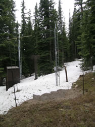 |
| Grizzly Peak Snotel, May 17, 2011 |
Grizzly Peak Snotel, May 2, 2012 |
 |
 |
| Near Rabbit Ears Pass, June 9, 2011 |
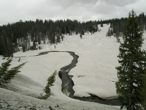
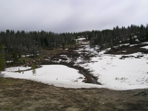
Near Rabbit Ears Pass, May 2, 2012 |
Recent CODOS Updates describe the early and dust-enhanced ablation of the paltry Colorado snowpack. On April 27th we issued Updates reporting that five of our ten CODOS snowpit sites – Grizzly Peak, McClure Pass, Park Cone, Spring Creek Pass,
and Willow Creek Pass – had lost all snowcover, that the McClure Pass Snotel had already reached “snow all gone” (SAG), and that the other associated Snotels were rapidly losing snow. In the days since then, the Snotels at Grizzly Peak and Park Cone have also reached or are very near SAG, at close to the earliest dates of SAG in their periods of record. Willow Creek Pass Snotel is also rapidly approaching SAG. Only Slumgullion Pass still retains roughly half of its Peak SWE, but melt rates are now very high there as well.
Our May 1st-3rd CODOS circuit focused on the other five CODOS sites that were thought to still retain snowcover at our snowpit sites, some likely on the verge of SAG – Grand Mesa, Rabbit Ears Pass, Berthoud Summit, Hoosier Pass and Wolf Creek Pass. Updates describe the substantial losses of snowcover SWE and depth since our early April snowpits at those sites, despite the (albeit small amounts of) precipitation received in April, and the declines in snowpack SWE at the adjoining Snotel sites, since peaking in March. At Hoosier, Wolf Creek and Berthoud passes, our snowpits were very shallow and our snowpit site was surrounded by or adjacent to patches of bare ground. At Grand Mesa and Rabbit Ears Pass our snowpits were deeper and snowcover was generally more continuous, although large open areas of bare ground are present on both of those sub-alpine plateaus. The nearby Rabbit Ears Pass and Berthoud Summit Snotels are both approaching their earliest-ever dates of SAG and the Mesa Lakes, Hoosier, and Wolf Creek Summit Snotels are also on track for near-record early dates of SAG as well.
At all five of those sites, a merged dust layer corresponding to events D4-D8 at Senator Beck Basin was fully emerged at the snowpack surface in our snowpit and on adjoining terrain. Only the highest, most northerly alpine terrain in the Front Range still retained enough recent new snow to generally hide the underlying dust from view, but some large patches of dirty snow were emerging. South, east, and west aspects had widely exposed dust, where snowcover remained. Based on this recently completed tour, it appears that Colorado dust-on-snow concentrations are strongest here in the San Juan Mountains, where snow albedo values at Swamp Angel Study Plot have recently been at or just below 50%, with merged dust layers D8-D4 fully exposed at the snowpack surface, and at Grand Mesa, where albedo values have also been in the mid-50% range.
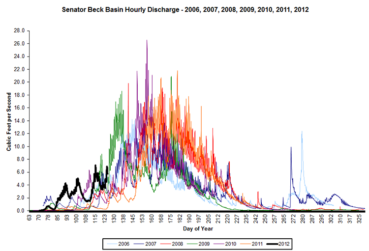
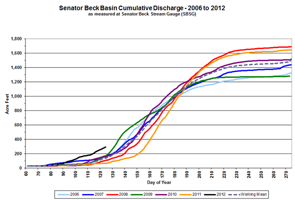
Beginning on/about April 20th or 21st stream flows showed remarkably similar, synchronized surging at most of the gauges that CODOS monitors, as recent new snow was ablated and dust re-emerged, during very warm weather. Then, most show a similar moderation in flows as unsettled, showery weather returned late in the month. In general, flows at those gauges were higher than normal in March and April, on a given date. Given the rapid loss of snowcover and Snotel SWE to historically early SAG in many locales, Spring 2012 runoff may have already peaked in many systems. Colorado runoff is now dependent on high elevation, largely alpine snowcover on wind loaded east-facing and north-facing terrain. Here in Senator Beck Basin, which ranges in elevation from 13,510’ to 11,031’ at the pour point, and which has had extended periods of comparatively high albedo in alpine terrain produced by new snow in April, runoff began in late March but we may not have yet seen peak flows or the passage of the center of runoff mass at the Senator Beck stream gauge.
This recent circuit of CODOS sites was our last for the season, but fieldwork will continue in Senator Beck Basin until SAG at our study plots – nearly 1 meter of snow remains at our alpine Senator Beck Study Plot, at 12,180’. As and when this snowmelt season concludes at our ten other CODOS sites, CSAS will update our database of Snotel snowmelt rates and prepare a final Season Summary.
Updates by Site:
Berthoud Summit (May 2) | Grand Mesa (May 1) | Grizzly Peak (April 27) | Hoosier Pass (May 3)
McClure Pass (April 27) | Park Cone (April 27) | Rabbit Ears Pass (May 2) | Senator Beck Basin (Apr 24)
Spring Creek Pass (April 27) | Willow Creek Pass (April 27) | Wolf Creek Pass (May 3)
Chris Landry, Executive Director
clandry@snowstudies.org
Center for Snow and Avalanche Studies
PO Box 190, Silverton, CO 81433 USA
(970) 387-5080
www.snowstudies.org

![]()


