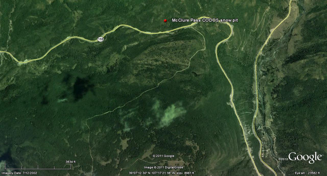
 CODOS Update for McClure Pass:
April 27, 2012
Summary |
Snowpack |
Melt Rate |
Stream Flows |
Forecast |
Previous Update
Summary
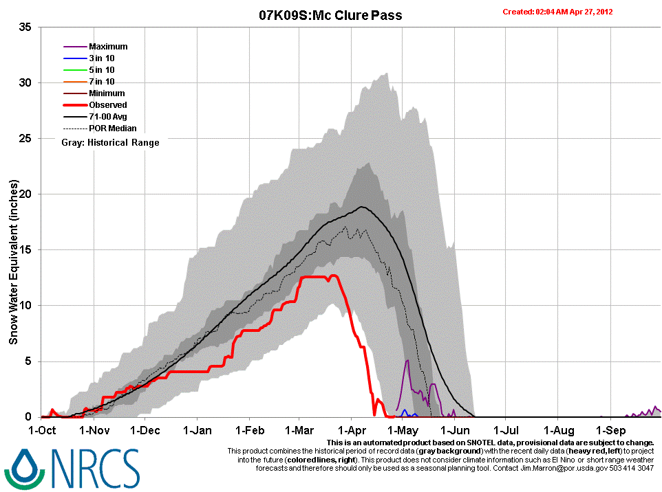
The McClure Pass CODOS snowpit site, in an open meadow immediately adjacent to the McClure Pass Snotel, had reached “snow all gone” (SAG) on April 11 and the Snotel itself first reached SAG on April 14 (followed by a brief restoration of SWE from new snow), earlier than any prior year in the period of record. The nearby Schofield Pass Snotel is now also headed toward a very early date of SAG that could precede the earliest date for SAG in the period of record at that site.
Given the early loss of this season’s scant low elevation snowcover, snowmelt runoff in the North Fork of the Gunnison and Crystal River watersheds is now dependent on the snowcover remaining largely above the Snotel network, in sub-alpine and alpine terrain. As observed during our early April CODOS circuit, desert dust is present, in varying concentrations, in the snowpack at those elevations throughout the State. A late April surge in streamflows included the influence of re-emergent dust as clean new snow deposited in mid-month was ablated by very warm and generally sunny weather. Recent unsettled, showery, and cooler weather, with some fresh snow, has not yet substantially slowed that surge in runoff. A return to sunny and dry weather will produce a more-or-less quick return to accelerating streamflows, depending on the depth of burial by clean new snow of the merged D8-D4 dust layer. However, currently well below median flows suggest that alpine and sub-alpine snowcover in the North Fork watershed may be less extensive than in the upper Crystal River valley, which is reporting well above median flows.
SnowPack Discussion
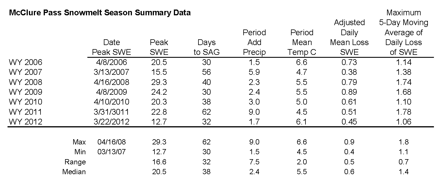
All snowcover is gone from the McClure Pass CODOS snowpit site; no new snowpit data since April 11, 2012. Our previous McClure Pass Update presents this season’s single snow profile and snow cover photos.
Melt Rate
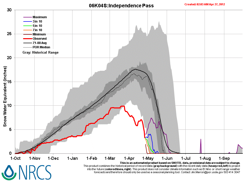
Peak SWE of 12.7" was recorded a few weeks earlier than normal at the McClure Pass Snotel, on March 20th, and the site then reached SAG on April 14th, just three days after our last site visit. A subsequent snow storm temporarily loaded the snow pillow with 1.5” of SWE. The mean daily rate of snowmelt from Peak SWE on March 22nd to (first) SAG on April 14th was 0.55”/day, a somewhat higher rate than in Spring 2011, and single-day melt rates exceeded 1”/day on several days. At the Schofield Pass Snotel, melt rates have recently been as high as 1.4”/day, with nearly 11” of SWE still remaining. Farther east, the Independence Pass Snotel is also rapidly losing SWE and may reach SAG at the earliest date in that site’s period of record.
Stream Flows
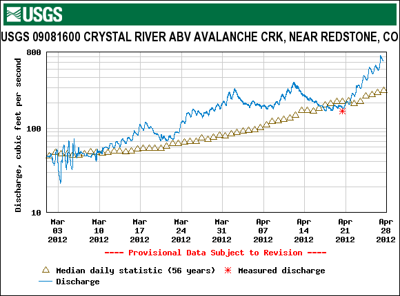
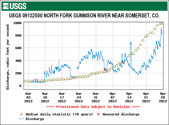
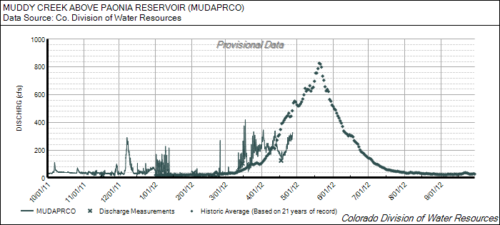
Following an early April surge ending soon after our site visit, declining local streamflows in mid-April on Muddy Creek, the North Fork of the Gunnison, and on the Crystal River corresponded with a period of unsettled, cooler weather and small snowfalls, and a restoration of higher snow albedo. Beginning on/about April 20, under a very strong high pressure regime bringing very warm and generally sunny weather, recent (clean) new snow was ablated by heating at the surface and, as the clean snow layer thinned and radiation penetrated that clean snow, by direct absorption of solar radiation in the dust underneath. As a result of that combination of very warm weather and reduced snow albedo, melt rates accelerated and stream flow surged again for several days. However, even with these surges, actual discharge remained well below median levels on the DWR’s Muddy Creek above Paonia Reservoir gauge and at the USGS’s North Fork of the Gunnison River near Somerset gauge, or just at median levels on the East River. In contrast, the USGS Crystal River above Avalanche Creek gauge reports discharge at well above median levels. General differences in the aspects and elevations of those watersheds may explain those different discharge rates. While the Crystal River headwaters contain considerable alpine and high sub-alpine terrain, with a substantial north-facing component, the Muddy Creek and North Fork of the Gunnison headwaters (above these gauges) have a lower proportion of alpine terrain, much of which is west-facing, and some of which faces south. During our site visit on April 11, dramatic differences in snowcover between the Crystal River headwaters and the Muddy Creek and North Fork headwaters terrain were readily apparent.
As of this writing Friday morning, April 27th, this recent surging in streamflows shows little effect from the return to unsettled, cloudy, and cooler weather in the past 24 hours. Lower elevation precipitation in the past 24 hours may have contributed to sustaining flows. The next episode of sustained sunny and dry weather will, depending on the depth of any clean new snow recently deposited on the remaining snow covered terrain, more-or-less quickly re-expose the old, low-albedo snow surface, resuming enhanced snowmelt runoff rates.
Forecast
The National Weather Service Grand Junction office expects cooler and drier air to replace scattered snow and rain showers by later today. Another comparatively dry system passes through Colorado on Sunday as near-normal temperatures return. Then, partly or mostly sunny weather brings a return to above-average temperatures under zonal, westerly flow early in the week, but with some continued chances for scattered showers. A system from the Pacific Northwest may deliver additional precipitation to northern Colorado from mid-day Tuesday into Wednesday.