 CODOS Update for Wolf Creek Pass:
Visited May 1, 2012
Summary | Snowpack | Melt Rate | Stream Flows | Forecast |
Previous Update
Summary
Since our prior site visit, on April 9th, Wolf Creek Pass received 2.8" of additional precipitation as snow. Two significant storms in mid-month and several other small snowfalls resulted in periodic restoration of higher snow albedo, quickly followed by a return to dust-reduced albedo values. As of Tuesday, May 2, the Wolf Creek Pass CODOS study site has experienced a net loss of 8.2” (208 mm) of SWE since April 9th, and only retains 4.4” (112 mm) of SWE in 13” (34 cm) of wet, isothermal snow. Dust layers D8-4 were merged at the snowpack surface in similar concentration, and with similar albedo reduction, as was observed at Swamp Angel Study Plot in Senator Beck Basin the day before.
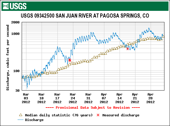
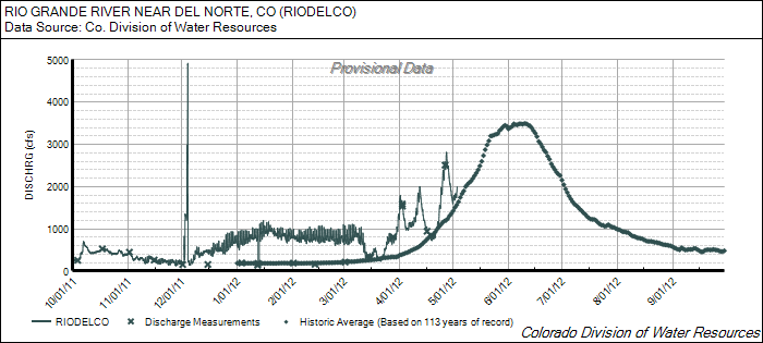
Snowmelt runoff is now dependent on snowcover remaining primarily on north aspects and wind loaded east aspects at the highest elevations; other aspects are notably free of snow. Streamflow was well above median levels for most of April on the Rio Grande at Del Norte, and for much of March and April on the San Juan River at Pagosa Springs, but both gauges are now reporting near-median flows.
SnowPack Discussion
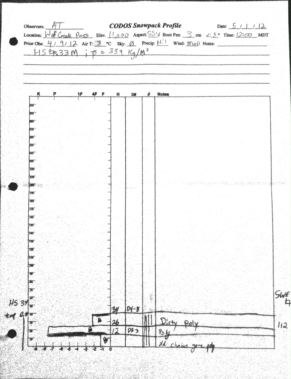
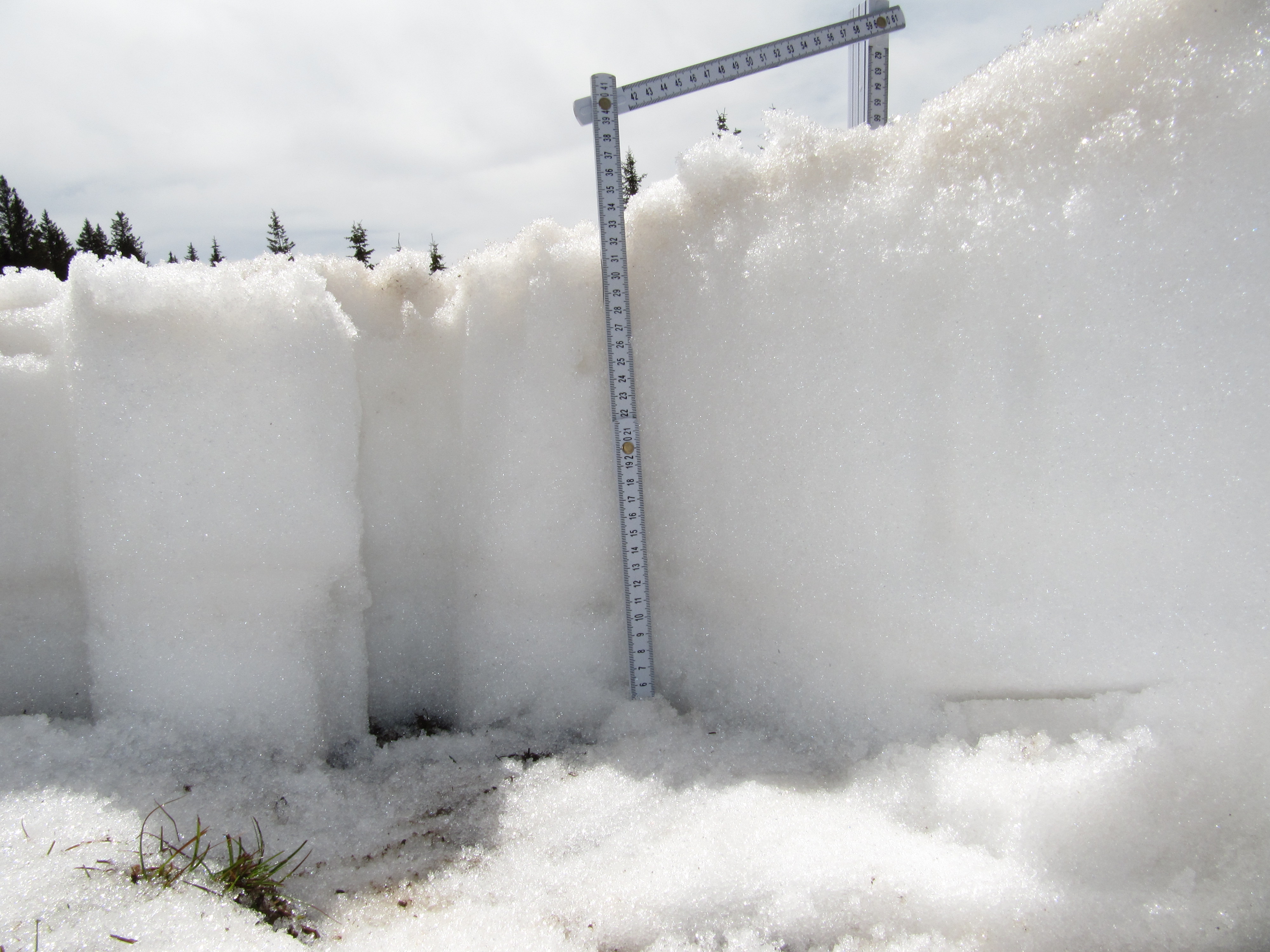
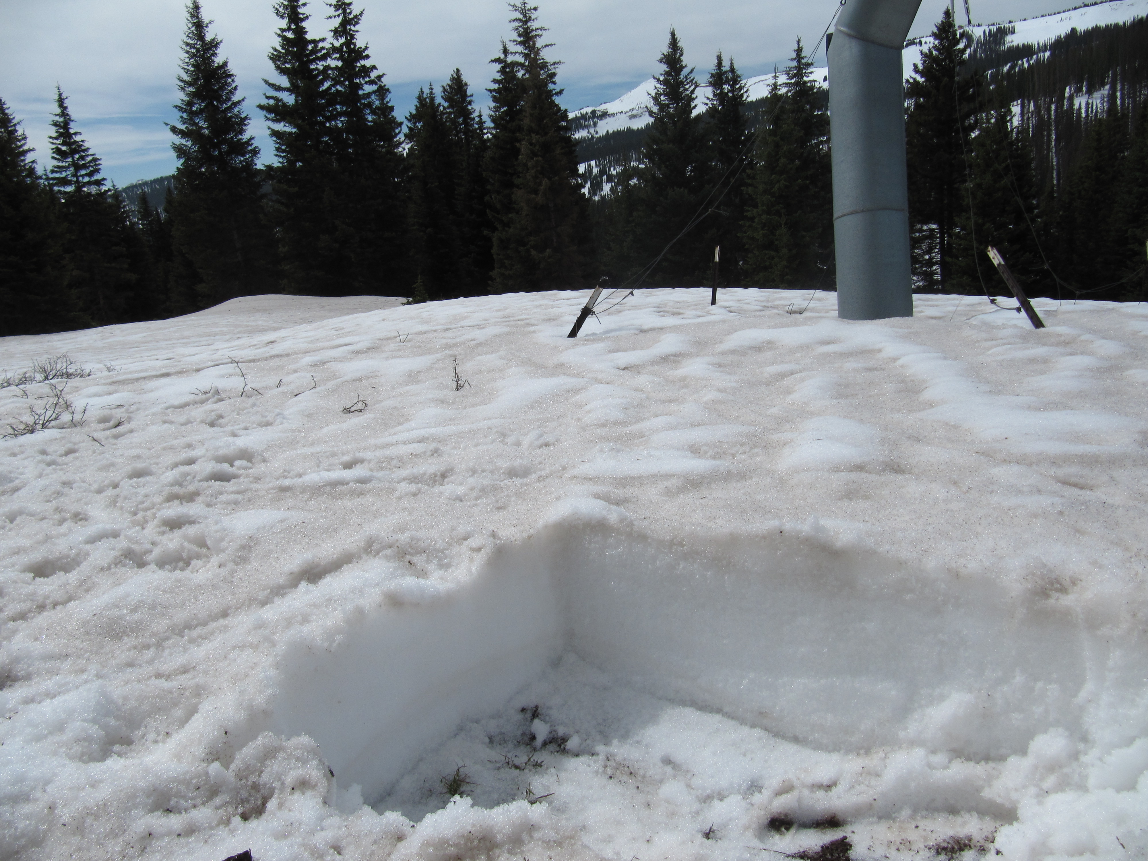
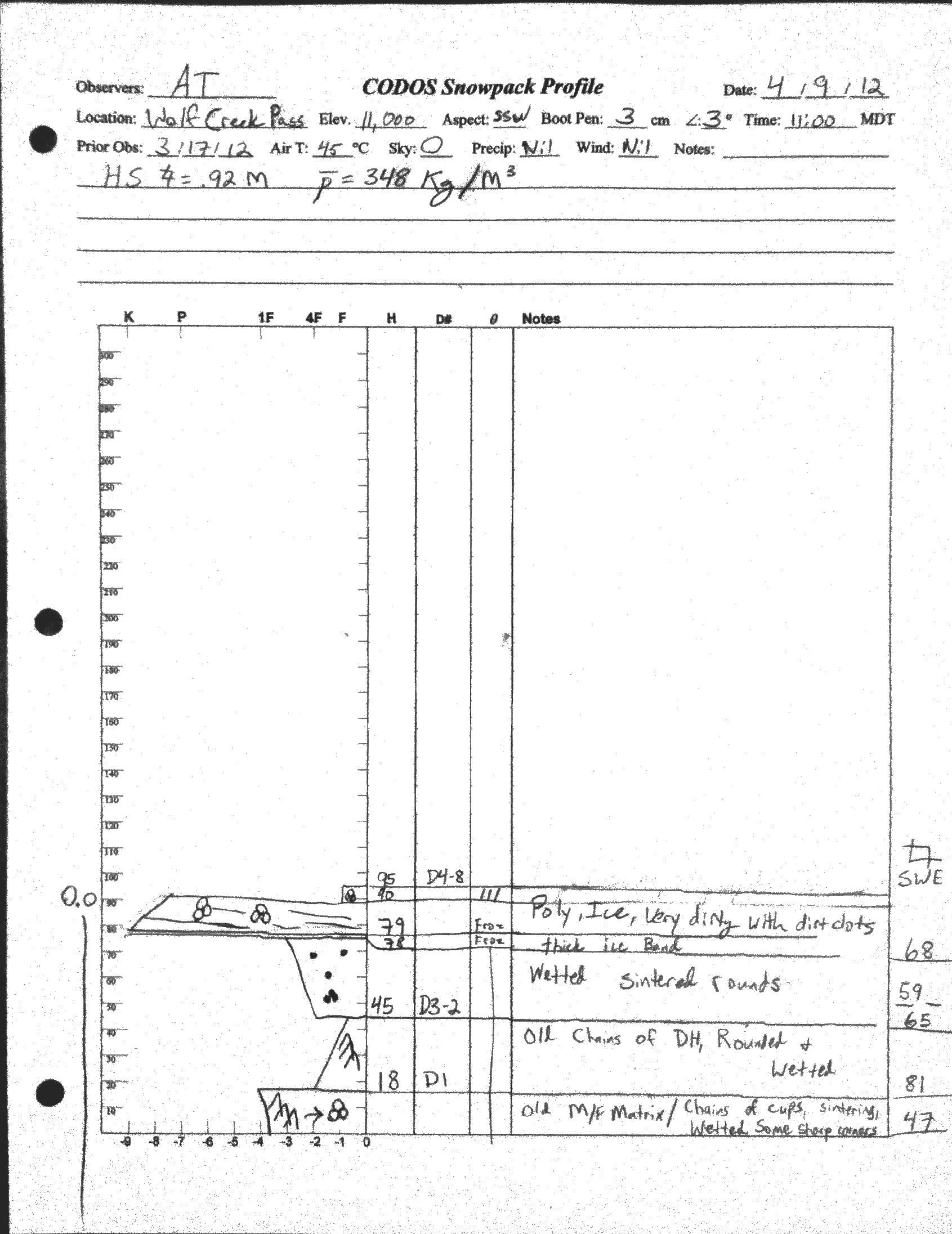
A snow profile performed May 1st at our Wolf Creek Pass CODOS site found a patchy, completely isothermal, and wetted snowpack with merged dust fully exposed. Dust concentrations on the snowpack surface at this site were comparable to those observed at Swamp Angel Study Plot on Monday, April 30th. Although our CODOS site still contained snowcover adjacent to our prior snowpit locations, large areas of open ground are present at Wolf Creek Pass.
Since our prior April 9th snowpit, total snowcover depth and snowpack SWE decreased at our Wolf Creek Pass CODOS plot by 24” and 8”, respectively, despite additions of nearly 3” of precipitation from new snow during mid-late April. As of May 1st, this plot retained only 13.0” of snow containing just 4.4” of SWE, and large patches of open ground immediately adjoin the location of our three CODOS snow pits this season.
| May 1, 2012: | |||||
 |
 |
 |
 |
||
| April 9, 2012: | |||||
 |
|||||
Melt Rate
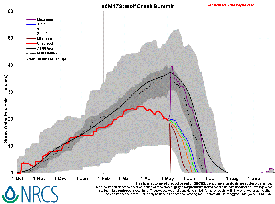
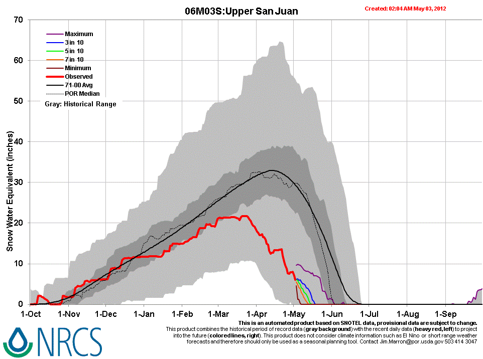
Following Peak SWE at the Wolf Creek Summit Snotel of 24.8” on March 23rd-25th, melt rates slowly accelerated up to 0.2-0.4” SWE per day, coinciding with deposition of dust layers D6, D7, and D8, through mid-April. Some additions of SWE followed and restored higher snow albedo, in mid-late April, before the re-emergence of the merged D4-D8 dust to the snowpack surface and resumption of snowmelt rates of up to 0.7” per day at the end of the month, before another light snowfall. At current melt rates, the Wolf Creek Summit Snotel will retain SWE for some time. Meanwhile, the more exposed, snowpack ablation at the thinly forested Upper San Juan Snotel site is much farther along and more rapidly approaching SAG, with dust fully exposed at the snowpack surface.
Stream Flows
The Rio Grande at Del Norte gauge reported well above median flows virtually throughout April, with one return to median levels during the unsettled weather of mid-April. Following a major surge in late April, and a return to cloudier, showery weather, more recent flows have moderated, returning to near-median discharge for early May. As discussed in the recent Rabbit Ears Pass Update (May 2), given the total loss of lower elevation snowcover and scant snowcover on highest elevation south-, east-, and west-facing terrain, further runoff is now largely dependent on high elevation snowcover in north-facing terrain. These Rio Grande at Del Norte streamflow data may signal that peak runoff has already occurred, or will take place shortly, shifting the hydrograph well forward in time.
A similar, perhaps even more pronounced shift may be reflected in San Juan River at Pagosa Springs data showing well above median flows beginning in mid-March and being sustained through April, with the exception of a mid-April return to near median flows during stormy weather that delivered up to two feet of new snow to the headwaters. Following a substantial surge in late April, coinciding with the re-emergence of merged dust layers D8-D4, another period of unsettled weather at the end of April brought a return to near median discharge levels by early May. Given the early loss of lower elevation snowcover in the San Juan River watershed, and rapidly diminishing snowcover on higher elevation south, east, and west aspects, further runoff is now dependent on alpine and highest elevation sub-alpine snowcover, on north aspects. These San Juan River streamflow data may signal that peak runoff has already occurred, or will soon, shifting the WY 2012 runoff hydrograph well forward in time.
Forecast
The National Weather Service’s Grand Junction office expects drier but windy weather for the remainder of the week, possibly producing critical fire weather in western valleys on Thursday and Friday. Then, over the weekend, a trough now in the Pacific Northwest will begin influencing Colorado weather but, despite uncertainty about how that trough may split, the system may be moisture starved and produce only scattered shower activity early next week, under near-normal temperatures.