
Data | Archived Data
For this year’s raw data (no QA/QC performed) or any questions about our data, send us an email at jderry@snowstudies.org. If you use our data, please donate and support the data collection you value! See our Funders page for information on who supports CSAS. And please read our Data Use Policy. See Current Conditions for near real-time data.
On this page (click to jump):
Weather station datasets and metadata
Snow pit profiles
Seasonal datasets and Sensor Status logs
Storm reports
Dust on Snow Mass Loading
Corrected radiation data/ground surface temperature
Plant data
CSAS data citations
ArcGIS data
Weather Station Data
| Swamp Angel Study Plot |
Senator Beck Study Plot |
Putney Study Plot |
Senator Beck Stream Gage |
|
|---|---|---|---|---|
| Metadata | SASP Metadata | SBSP Metadata | PTSP Metadata | SBSG Metadata |
| Variables | SBSG_Var | |||
| Entire POR Datasets |
SASP_1hr_2010-2024 SASP_1hr_2003 -2009 SASP_3hr_2003-2024 SASP_24hr_2003-2024 |
SBSP_1hr_2010-2024 SBSP_1hr_2003-2009 SBSP_3hr_2003-2024 SBSP_24hr_2003-2024 |
PTSP_1hr_2004-2024 PTSP_3hr_2004-2024 PTSP_24hr_2004-2024 |
SBSG_1hr_2005-2024 SBSG_24hr_2005-2024 |
| Serially Complete Meteorological Datasets |
SASP_forcing Metadata |
SBSP_forcing |
Seasonal Datasets
Summer (s) and Winter (w) datasets. For Snow Pit Profile Metadata, see CSAS Snow Profiles Metadata.
Snow Pit Profiles (PDFs)
WY 2007 Snow Pits
WY 2008 Snow Pits
WY 2009 Snow Pits
WY 2010 Snow Pits
WY 2011 Snow Pits
WY 2012 Snow Pits
WY 2013 Snow Pits
WY 2014 Snow Pits
WY 2015 Snow Pits
WY 2016 Snow Pits
WY 2017 Snow Pits
WY 2018 Snow Pits
WY 2019 Snow Pits
WY 2020 Snow Pits
WY 2021 Snow Pits
WY 2022 Snow Pits
WY 2023 Snow Pits
WY 2024 Snow Pits
WY 2025 Snow Pits
Winter Storm Reports
For POR Winter Storm Data see CSAS_Storms_Precip_Data_WY23. For near real-time data, see Current Conditions. The day is identified by Julian day of the year (DOY). Download a Julian day calendar here for 2023, and 2024.
- CSAS Storm Definition >= 12 mm SWE with no break in precipitation >12 hours
- SASP =Swamp Angel Study Plot(11,060′, in sub-alpine meadow)
- SBSP =Senator Beck Study Plot(12,186′, on alpine bench)
- PTSP =Putney Study Plot(12,323′ alpine ridge ‘free air’ site)
WY 2012 Storms
WY 2013 Storms
WY 2014 Storms
WY 2015 Storms, WY 2015 Storm Reports Log
WY 2016 Storms, WY 2016 Storm Reports Log
WY 2017 Storms, WY 2017 Storm Reports Log
WY 2018 Storms, WY 2018 Storm Reports Log
WY 2019 Storms, WY 2019 Storm Reports Log
WY 2020 Storms, WY 2020 Storm Reports Log
WY 2021 Storms, WY 2021 Storm Reports Log
WY 2022 Storms, WY 2022 Storm Reports Log
WY 2023 Storms, WY 2023 Storm Reports Log
WY 2024 Storms
WY 2025 Storms
WY 2026 Storms
Dust-on-Snow Mass Loading
Data for Dust deposited on snow cover in the San Juan Mountains, Colorado, 2011–2016: Compositional variability bearing on snow-melt effects.
Full Citation: Reynolds, R.L., Goldstein, H.L., Moskowitz, B.M., Kokaly, R.F., Munson, S.M., Solheid, P., Breit, G.N., Lawrence, C.R., and Derry, J., 2020, Data for Dust deposited on snow cover in the San Juan Mountains, Colorado, 2011–2016: Compositional variability bearing on snow-melt effects: U.S. Geological Survey data release, https://doi.org/10.5066/P9RGQ9KX.
Physical and chemical data for dust deposited on Colorado Rocky Mountain snow cover during water year 2013 through water year 2016.
Full Citation: Goldstein, H.L., Reynolds, R.L., Molden, N., Lowers, H., Breit, G.N., Williams, E.W., Lawrence, C.R., Kokaly, R.F., and Derry, J., 2024, Physical and chemical data for dust deposited on Colorado Rocky Mountain snow cover during water year 2013 through water year 2016: U.S. Geological Survey data release, https://doi.org/10.5066/P13HIOO8.
Corrected Radiation Data
Senator Beck Basin Corrected Radiation (Water Years 2005-2023)
SnowEx20 Senator Beck Basin Transect Ground Surface Temperature, October 8, 2019 – July 19, 2020
ArcGIS Data
We have created three GIS data layers:
- Senator Beck Basin Study Area watershed boundary
- Study plot locations
- Transect end points for the baseline vegetation monitoring program
Five additional GIS data groups are compiled from publicly available data. Those groups include:
- 10 m raster grids of digital elevation models (DEM)
- Vegetation coverage
- Geology
- Topography and place names
- Air photos
All GIS data are in ArcGIS file format (created with ArcGIS 10.1). Please contact Jeff Derry (jderry@snowstudies.org) and we can send you the GIS data. Files are too large to store on our website.
Plant Data
Vascular Plant Species Distribution and Diversity(flowers, grasses, shrubs):
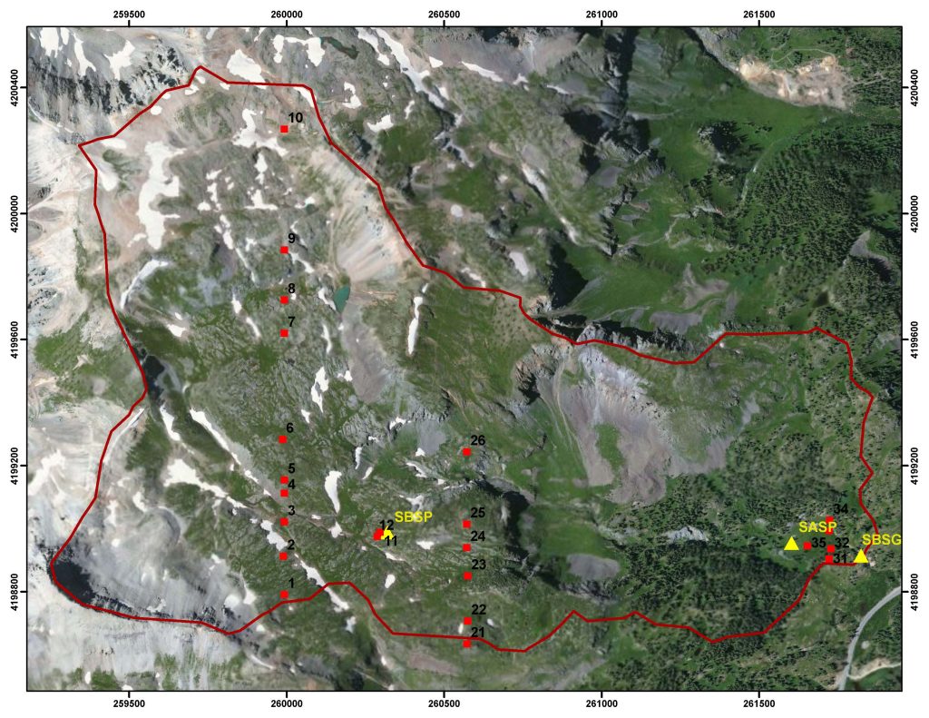
CSAS has contracted with the Colorado Natural Heritage Program to perform repeat surveys of the Senator Beck Basin vascular plant communities every 5 years. Plant communities are a significant factor in understanding snowcover distribution and water utilization in mountain systems. Altogether, twenty-three 100′ transects are monitored, in 230 micro-plots, at three general elevations – twelve in the alpine tundra, six at/near treeline, and the remaining five in the subalpine. This map indicates the locations of each of the twenty-three 100′ transects. Survey monuments were placed at each end-point of each transect to facilitate repeat studies. The original baseline study was conducted during the summer of 2004, was repeated in 2009, in 2014, and again in 2021. The complete 5-year repeat 2009 report (pdf) and original 2004 Species List(xls) are available for download.
Below: Colorado Natural Heritage Program botanist Peggy Lyon (right) and National Park Service botanist Julie Crawford cataloged plant species inside a 0.1 m2 Daubenmire frame on transect #11, located near the Senator Beck Study Plot instrument tower.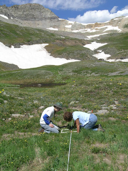
July 2009 Update: Senator Beck Basin Plant Community Inventory Repeated
Beginning on July 6, 2009, five years after our July 2004 “baseline” inventory of the Senator Beck Basin plant community, a very talented team of expert alpine botanists performed a second, repeat inventory using the same set of 22 transects established in 2004. Peggy Lyon and her assistant Dawson White, both of the Colorado Natural Heritage Program, and CSAS friend and collaborator Sara Simonson, from the Natural Resource Ecology Laboratory at Colorado State University, spent five very long and intensely focused days in the field, often on hands an knees, documenting the species present within 220 micro-plots (of 0.5 m2) along 22 separate transects ranging from 11,000’ to 13,000’. New species not identified in 2004 were found, species that were identified in 2004 were found in greater or lesser abundance, and other variations and surprises emerged, demonstrating the value in long-term monitoring. The team’s hard-won data was subsequently evaluated by another botanist who took part in the 2004 study, Julie Crawford, using statistical methods designed to quantify diversity and variation in species distributions across the three elevation zones (tundra, treeline, and sub-alpine) targeted by this monitoring effort. Although no conclusions about affects of global change can be drawn from just two sets of data, spaced five years apart, the 2009 effort was an essential link in what we hope will be a long chain of repeat studies with the statistical robustness to reveal the presence or absence of such affects and inform those interested in mountain systems in Colorado and elsewhere.

Above: Peggy Lyon (right), Dawson White, and Sara Simonson

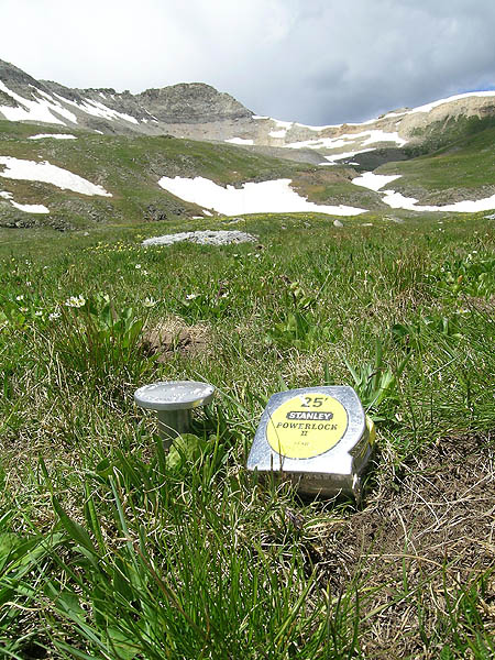
Above: Detail is everything, in the identification of as many as 15 different plant species, at differing stages of seasonal development, within a single 0.5 m2 micro-plot.
July 2014 Update: Third survey of Senator Beck Basin vascular plant community completed: in a marathon effort from July 19-27, botanists Peggy Lyon, Sara Simonson, and Renee Rondeau completed our third comprehensive inventory of the Senator Beck Basin plant community. Gordon Rodda also assisted. Species and coverage were documented in a total of 230 plots of 0.1 m2 along 23 established transects at three different elevation bands, in the sub-alpine, at treeline, and across alpine tundra.
October 1, 2023: Field work from the last survey in 2022. The thesis report was completed by Caitlin Harvey with Western Colorado University. It summarizes changes in the Basin since 2004. Read her thesis: Alpine Plant Community Dynamics and Climate in the Senator Beck Basin
Forest Health
Lower Senator Beck Basin contains many acres of sub-alpine ‘spruce/fir’ forest cover. These trees are representative of the ‘spruce/fir’ forest type found throughout the San Juan Mountains and in other Colorado mountain ranges. Recent severe ‘spruce beetle’ infestations in the San Juan Mountains have caused massive die-off and enabled large forest fires. In the fall of 2013, CSAS contracted graduate student David Scott, from Colorado State University, to extend his recent surveys of forest health elsewhere in the San Juan Mountains to include an assessment of conditions in lower Senator Beck Basin. Our intent was to capture baseline data while the forest was, apparently, still relatively healthy, prior to any significant spruce beetle infestation in this watershed. His work did, in fact, find a relatively healthy spruce/fir system and revealed interesting findings about critical parameters driving forest conditions. His report to CSAS is available here: (SBB_TreeVigor_2013_Dks_Final20140820.pdf)
CSAS Data Citation
Data users should reference: Landry, C. C., K. A. Buck, M. S. Raleigh, and M. P. Clark (2014), Mountain system monitoring at Senator Beck Basin, San Juan Mountains, Colorado: A new integrative data source to develop and evaluate models of snow and hydrologic processes, Water Resources, 50, doi:10.1002/2013WR013711.