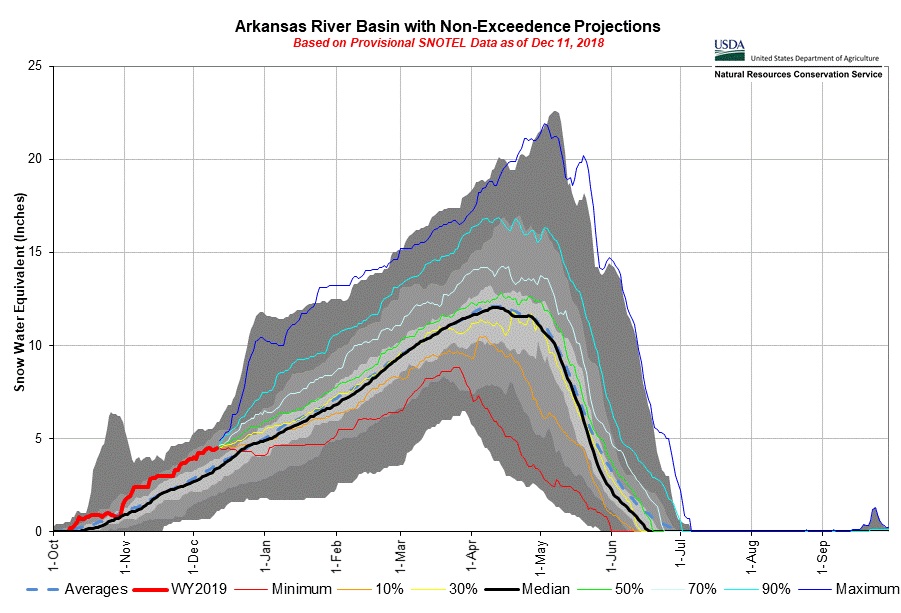
MOUNTAIN SYSTEM MONITORING: WINTER STORM DATA
This Precip and Storm Report Excel Workbook contains the current and past 13 seasons of CSAS winter storm data, including:
- Dates, times and duration of each winter storm event (2003-current)
- Change in the height of snow at both our alpine Senator Beck study plot and our subalpine Swamp Angel site.
- Peak gust data from our Putney site.
- Mean and maximum precipitation intensity during each storm
- Total new water accumulation in mm for each storm event.
- Summary data for each month of the season.
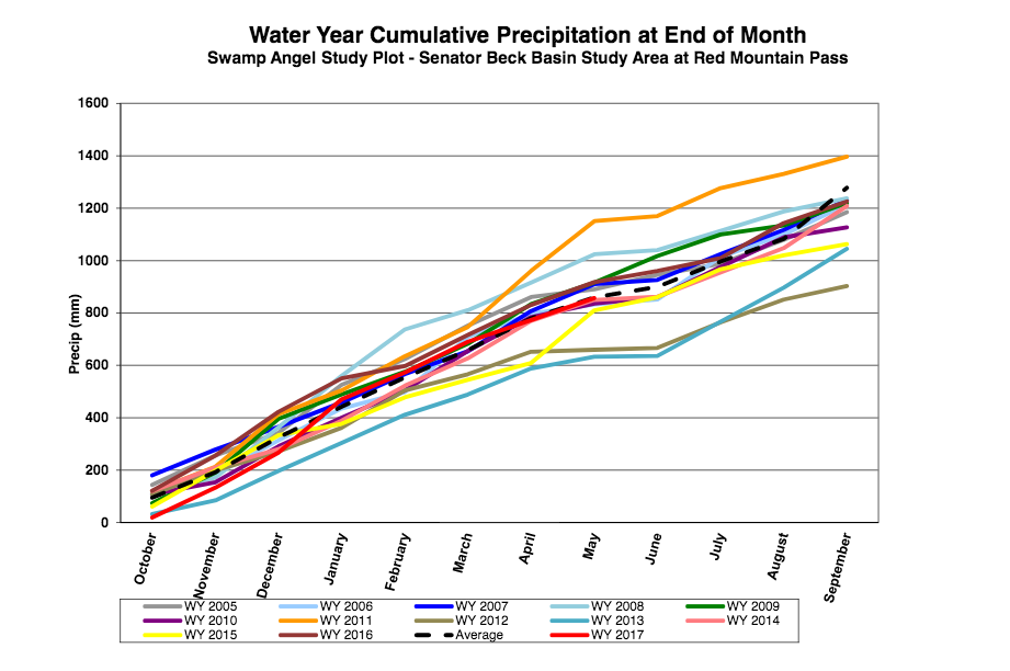
- Cumulative annual precipitation graph by month
See our Current Conditions for the latest hourly data. All times shown are in Mountain Standard Time (MST)
2018-2019 Winter Storm Reports
CSAS Winter Storm #27, May 19-23, 2019:
[br]
Greetings from Silverton,
[br]
Last weeks period of overcast and cruddy weather moved out on Thursday. The duration for what is considered Storm #27 was 106 hours where did not have a break in precipitation greater than 9 hours. The 5 days brought 2.3″ of water and a foot of snow at SASP and over 13″ of snow at SBSP. The wind got brisk towards the tail end, reaching 89.6 mph and brought dust-on-snow event #7, details on that soon. Since Friday we have seen a bit of a warm-up and streamflows starting to react. Not to last for too long though, the forecast starting today is for good chances of precipitation through Friday, and a Storm Watch starting tonight (Monday) lasting through Tuesday morning. It is currently drizzly and foggy/overcast here in Silverton. Enjoy the cool, Western Oregon type weather. Remember how dreadfully hot it was last year?
[br]
[br]
Winter Storm #26, May 16-18, 2019:
[br]
Greetings from Silverton,
[br]
A wet spring storm moved through the area at the end of last week ending on Saturday, and another one has been dumping since Sunday, May 19. The first storm, Storm #26, brought dust event #5 and Storm #27 (we will issue Storm Report #27 once it is over) brought dust event #6. Storm #26 brought 23 mm (0.9″) precipitation over a 47 hour period. Since May 16 we have received 2″ of precipitation and around 10″ snow accumulation at SASP and 16″ at SBSP. The wet winter continues into a wet spring. The general forecast calls for increased chances of precipitation and cooler temperatures over the next couple weeks as we head into peak streamflow time-frames.
[br]
CSAS Winter Storm #25, May 8-10, 2019:
[br]
Greetings from Silverton,
[br]
Storm #25 was a bit of a dud. We got a storm out of it but it was a fraction of the 4″ precipitation that was forecasted in the San Juan Mountains anyway. It provided 16 mm (0.6″) of precipitation and a few inches of snow accumulation. Though this storm too, like Storm #24, was associated with cooler temps and overcast conditions. Again, adding slightly to the snowpack and extending the snow season. The forecast is still calling for chances of precipitation this week so peak SWE may still be in the near future at Red Mt Pass, but likely we are now past that point as a warm period settles in for a few days. But more precip will add even more to the snowpack – adding to cumulative SWE for the season.
[br]
CSAS Winter Storm #24, April 29 – May 1, 2019:
[br]
Greetings from Silverton,
[br]
Storm #24 was responsible for 58 mm (2.3″) of water at SASP over a 60 hour period. This storm was a great late season bonus and accounted for the bump we see in the snow hydrographs on May 1. It fell as wet snow or rain at lower elevations. It provided cloud cover and cooler temperatures that has helped extend the ablation season.
[br]
Winter Storm #23, April 13-14, 2019:
[br]
Greetings from Silverton,
[br]
Storm #23 slipped through the cracks. Having occurred April 13-14 right after the larger storm from April 9-12, it was almost a carryover from that event, which brought dust event #3. But it was a storm by our definition nonetheless. Not much to say about his storm since I don’t remember much about it (writing this on May 12). But for those of you wanting to keep your records straight please see storm details in the link below.
[br]
[br]
CSAS Winter Storm #22:
[br]
Greetings from Silverton,
[br]
Tuesday night thru late Thursday night we received Storm # 22 here at Senator Beck. The storm started out of the S-SW with high winds hitting 73 mph. The wind shifted out of the North but remained strong. The beginning of this week we will issue a CODOS Update of our observations of a new dust-on-snow event. The good news is this storm brought 13.3″ of new snow with 1.5″ of water. This afternoon, about 34 hours after the storm passed, we received another 02″ of precipitation making it a total 1.7″ since Tuesday night.
[br]
The active weather patterns experienced this winter is continuing into spring. We will see a warming trend Sunday thru Tuesday then Tuesday night into Wednesday night a cold front passes over Colorado bringing widespread precipitation. Cold temps will stick around until Friday when we see a warm up Friday/Saturday.
[br]
[br]
CSAS Winter Storm #21:
[br]
Greetings from Silverton,
[br]
Storm 21 did not bring as much excitement to the San Juans as Storm 20, probably for the best as far as CDOT highway crews, CAIC, and backcountry recreationalists are concerned. With 1.1 inches of water and winds averaging 17.5 mph, Storm 21 can be considered relatively moderate compared to our recent “cyclone bomb” storm cycle. The break from the heavy storm cycles allowed CDOT to re-open Red Mountain Pass after a 17 day closure. With this opening we can safely travel to the SASP to adjust our snow depth sensor and make additional maintenance inspections this week.
[br]
Despite the fact it appears as though Spring has sprung with advent of daylight savings, Storm 21 (in addition to some more precipitation forecasted for later this week) continues to remind us in the San Juans that winter is not yet over.
[br]
Please see Storm 21 attached.
More to come soon!
CSAS Winter Storm #20: And Another 3.1″ Precipitation
[br]
Greetings from Silverton,
[br]
It has been an epic period in our WY2019 winter season. Storm #20 was historic for Colorado for reasons like we all learned the definition of
bomb cyclone and also hitting a
record minimum pressure reading. But more than that, the series of storm events since first part of February has made for one of the most intense 6 weeks of snow accumulation we have ever experienced. This has set up the high country for
historic avalanches. 300-year event avalanches, see this nice article from the
Aspen Times about the Conundrum slide, Art Mears, avalanche consultant and CSAS Board member commented that this was “the largest Colorado avalanche I know of in my 46 years consulting”.
[br]
Everybody has their own personal story in regards to these storms. My story began being grateful we didn’t take a long weekend and float the Salt River because we were concerned flows would exceed ~5,000 cfs. Discharge ended up peaking at 30,000 cfs near
Roosevelt, AZ. Tuesday we woke up to 20″ of overnight snow accumulation in South Fork, pouring rain and lightening between Pagosa and Durango, to even more snow back in Silverton.
[br]
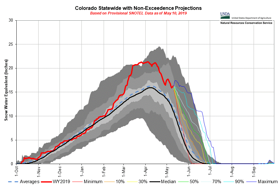
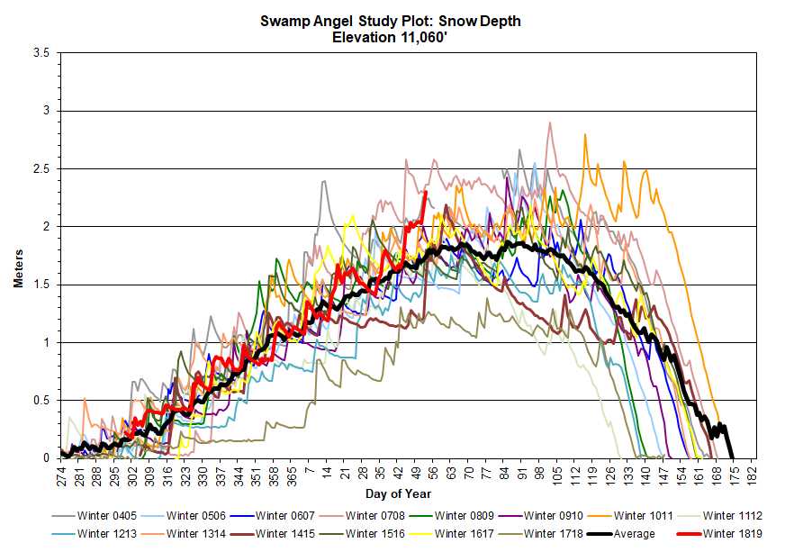
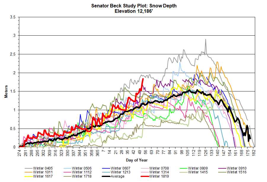
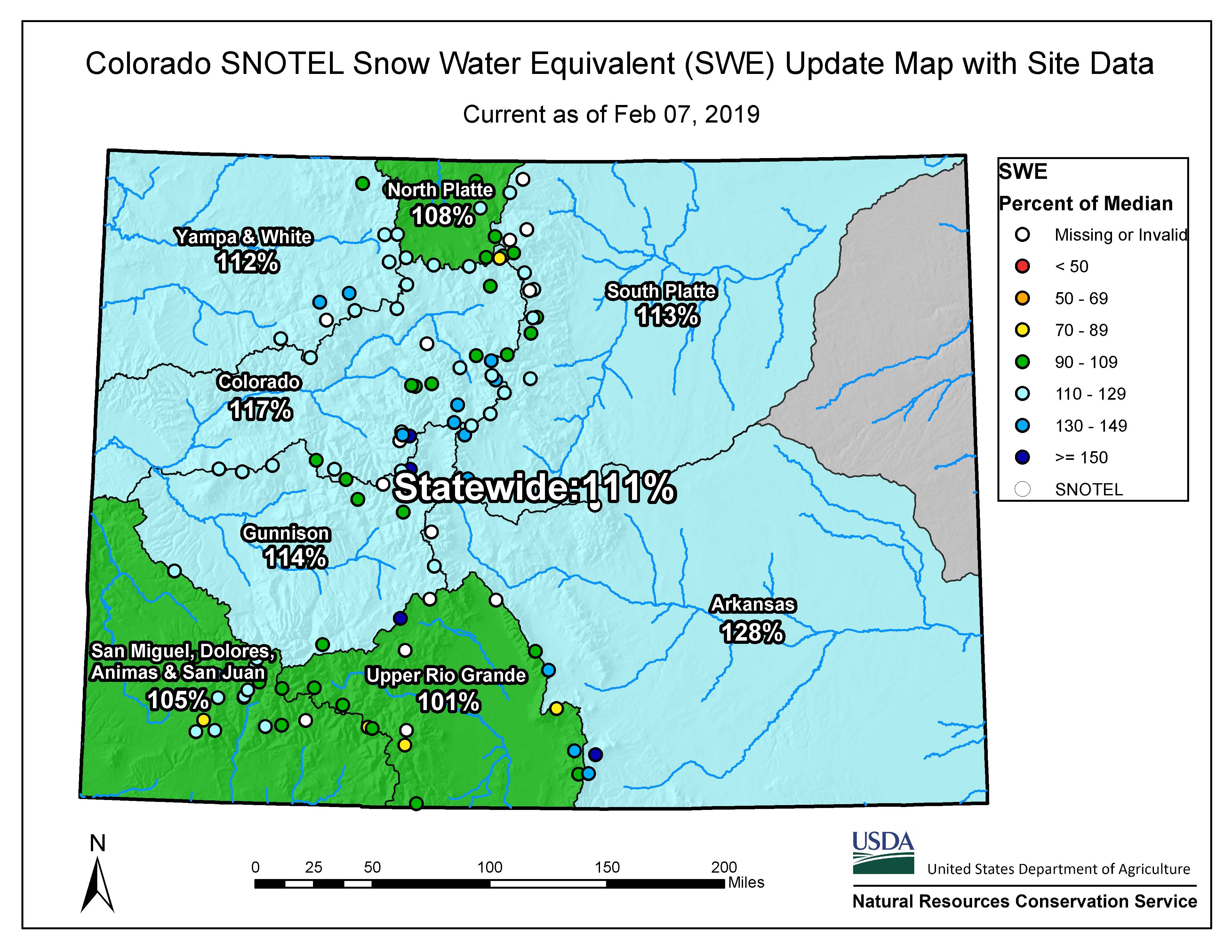
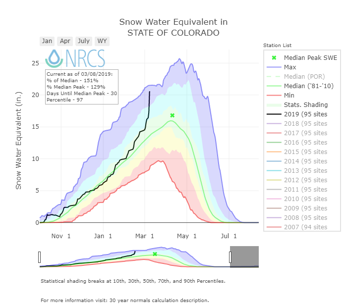
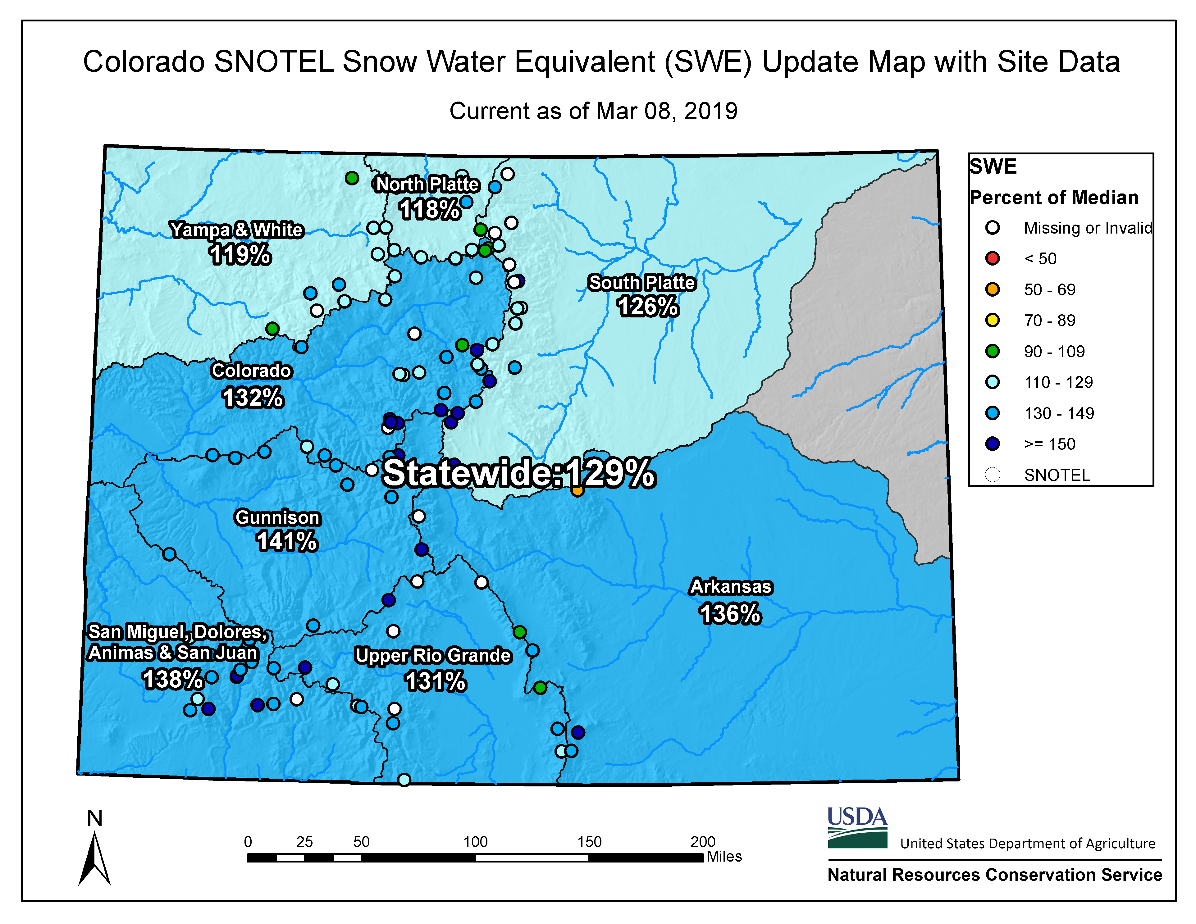
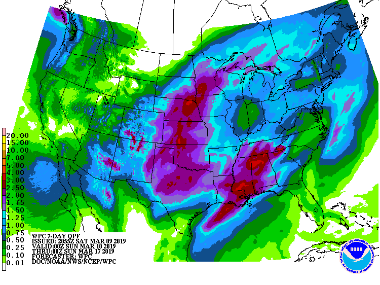
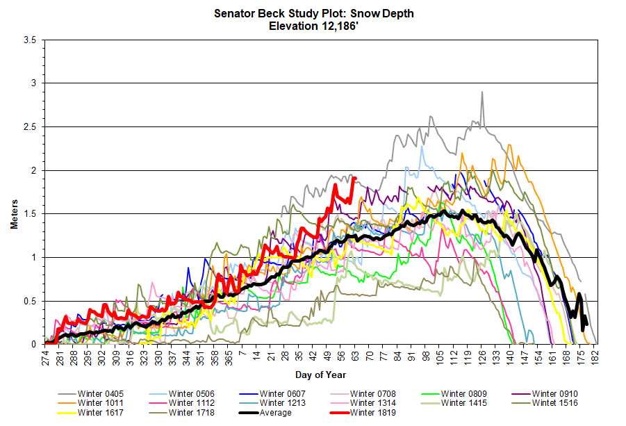
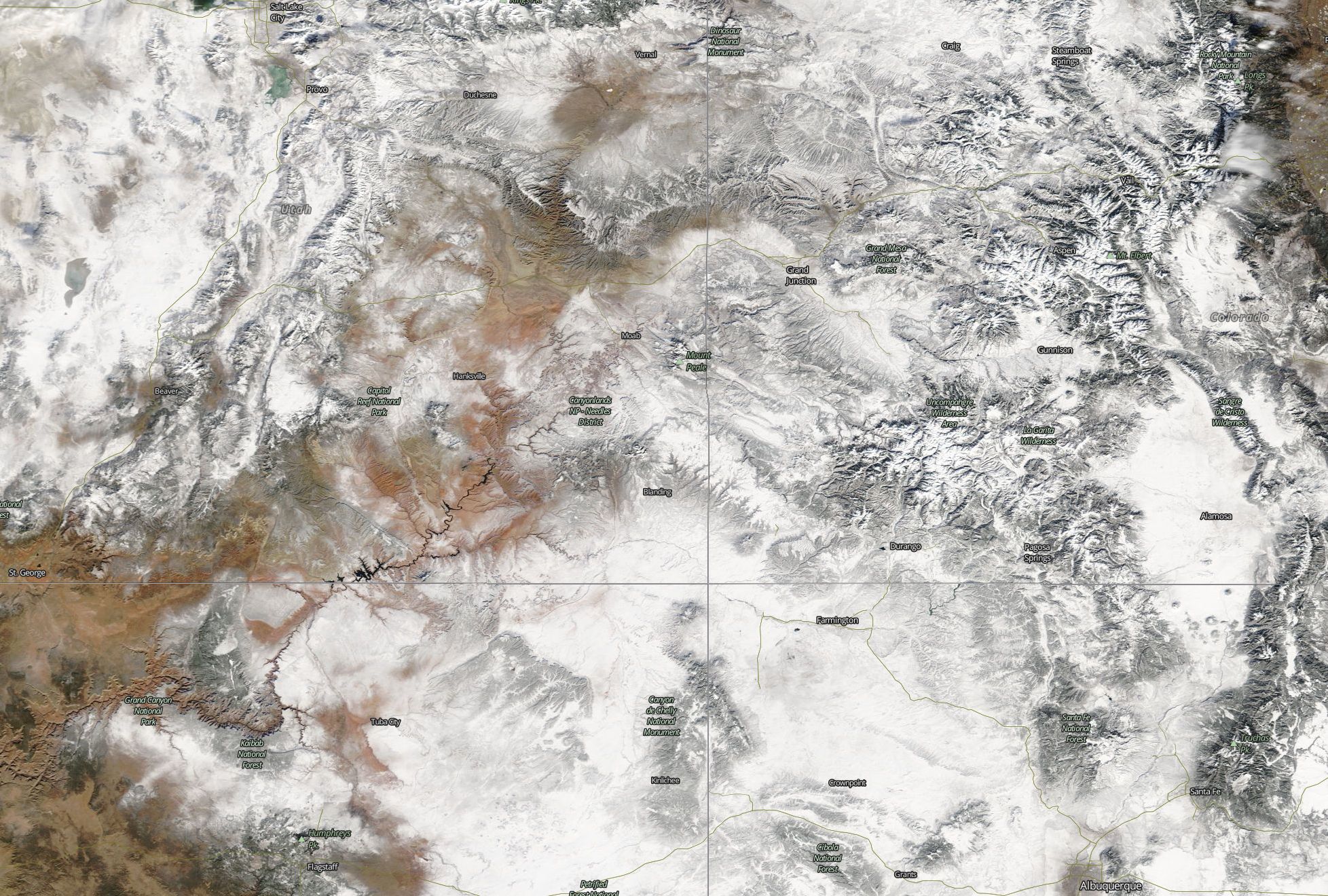
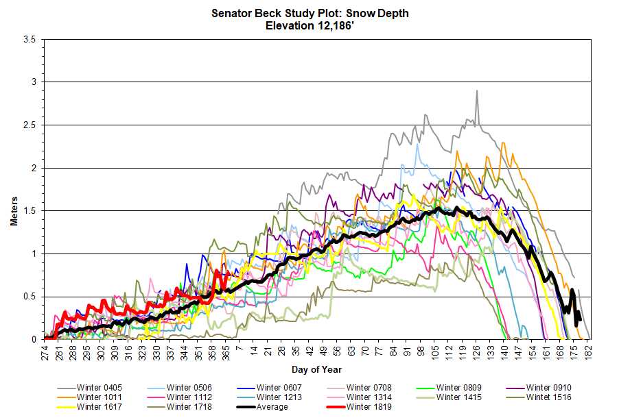
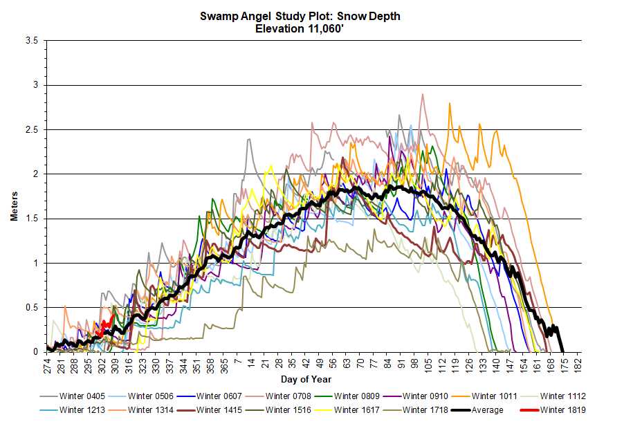
Back in Silverton, the road crews and CAIC are working hard to mitigate and clear multiple avalanches from highway 550 and surrounding county roads. At SASP, Storm #20 was another warm, wet one. Rain/snow line was reportedly at ~10,500′ in the region. It brought another 7.8 mm (3.1″) water content with 14 cm (5.5″) new snow accumulation at SASP and 50.6 cm (19.9″) at SBSP. Our average total precipitation for the month of March is 103 mm (4″), we busted that the first 8 days of March with 110 mm (4.3″). Total for March so far is 193 mm (7.6″) precipitation. We are now sitting, in terms of average cumulative precipitation since the start of the water year, where we are usually at the end of April, going by data in our period of record. Strong winds have accompanied all of our storms forcing the redistribution of snow above treeline, with the recent storms being so moist it helped for a more cohesive snowpack to not be as easily transportable, and stick around more so at these higher elevations. Our SBSP tower is at 12,186′, higher than any SNOTEL site, and it is showing the most snow ever in our POR for this time of year, only WY2005 had near as much snow (see plots attached). Our stations seem to be holding up well for not being able to access for a couple weeks, although the snow accumulation has now reached the base of our snow depth sensor at SASP. It will need to be raised when we can safety travel to Red Mt Pass and visit the site. Most SNOTEL stations are showing they are currently ranked between 1-10 for most SWE observed in their POR.
[br]
On Saturday we hope to take advantage of the nice weather and do our March CODOS tour to look for dust-in-snow around the state. If you would like to receive updates as to when we issue CODOS observations please send me an email.
[br]
[br]
More soon
[gdgallery_gallery id_gallery=”4″]
CSAS Winter Storm #19: Yet Another 2.2″ Precipitation
[br]
Greetings from Silverton,
[br]
Two back to back storm systems, with about a 7 hour gap between them, occurred Wednesday, March 6 to Saturday, March 9 to comprise Storm #19 for the season. The first system was notably wet, snow (barely snow) melting as it hit the ground and not producing much accumulation. Things cooled down a bit for the second phase allowing the snow to remain snow. This was another whopper, over the 77 hours we recorded another 57 mm (2.2″) precipitation. As was Storm #18. Strong winds out of the SW with gusts up to 80 mph kept things interesting, we noted dust event number 2 (D2) for the season. More details about that will be covered in our CODOS updates. At SASP since March 1 we have received 115 mm (4.5″) precipitation. For Colorado as a whole, median peak SWE usually occurs around April 10 at 16.8″ SWE. Presently, right about 1 month away from April 10, Colorado is near 18-20″ SWE (there seems to be a discrepancy of current SWE depending on what projection plots you look at).
[br]
Never a dull moment this winter, the next system is cued up with 8″-14″ forcasted for the San Juans and lesser amounts towards the central mountains Monday morning thru Tuesday morning. But then a colder quick moving trough is expected to enter the area Tuesday night thru Thursday morning.
[br]
Please see Storm Report attached.
[br]
[br]
CSAS Winter Storm #18: Another 2.2″ Precipitation
[br]
Greetings from Ridgway,
[br]
As I write this in Ridgway, waiting for Red Mt Pass to reopen, it looks to be a beautiful mostly sunny day in the San Juans. The mountain landscape is covered in a blanket of deep, fresh snow from Storm #18 that swept through from Saturday morning thru Monday morning. Driving in from the Front Range yesterday I saw an entire state covered in a blanket of snow from the recent storms, Fort Collins ~10″, Colorado Springs ~8″, South Park a wind swept ~6″. I’d be curious to know the current energy budget (incoming and reflected/outgoing energy) of the state due to this fresh snowfall. Our SBB stations reported heavy snowfall for this 50 hour storm that dropped 2.2″ precipitation with about 51 cm (20″) snow accumulation at SASP and 30 cm (12″) at SBSP. Precipitation intensity was an average 1.12 mm/hr. Winds were variable out of the southwest to northwest.
[br]
We’ll see what it looks like in terms of SWE when we do our next snow profile, but it is one of the healthiest snowpacks for this time of year in our period of record. Remnants of the next relatively warm atmospheric river event will be entering Western Colorado on Wednesday.
[br]
CSAS Winter Storm #16 and Storm #17
[br]
Hello from Silverton,
[br]
Storm #16 hit the San Juans on Sunday afternoon. With peak precipitation rate at 1 mm/hr, the snow trickled in slow and steady over a three day period accumulating in 0.7 inches of water by Tuesday night. Several moisture surges and shortwave troughs released the precipitation with wind averaging between 10 and 20 mph; considerably calmer conditions than Storm 15. Peak gust from Storm 16 was 50.8 mph.
[br]
Storm 16 concluded with a winter advisory watch for HWY 550 due to convective snow in the Uncompahgre Gorge and westerly winds effecting visibility. This advisory expired late Tuesday night, however the break in storm conditions did not last long. 19 hours later Storm #17 rolled in to western Colorado from the Pacific Northwest. This storm can be characterized by cold temperatures, high moisture content, and slightly higher wind speeds (average 19 mph) compared to Storm #16. Storm 17 wrapped up late last night.
[br]
Storm 17 lasted 61 hours and at least 1 mm of precipitation was recorded 35 of those hours, for a total of 1.6” water. Over the past 11 days beginning when the atmospheric river first rolled into Colorado, we have received 4.5” of water with 26” of snow accumulation at SASP and 24” even at the higher wind effected elevation of SBSP. Over the past 23 days of February, 16 days brought precipitation to Senator Beck totaling 6.5” of water. It has been very impressive watching the NRCS SWE plots go almost vertical during this timeframe. For the moment the Rio Grande and San Miguel/Dolores/Animas/San Juan Basins are showing slightly more snow compared to median than basins in Northern Colorado, I am trying to remember the last time this happened.
[br]
The Southwest is now enjoying a bit of sunshine and warmer daytime temperatures that typically characterize the San Juan Mountains.
[br]
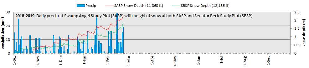
Please see below for snow and precipitation graphics from SBB and NRCS. And also please see storm reports #16 and #17 attached.
[br]
More Soon
[br]
[gdgallery_gallery id_gallery=”3″]
[br]
Winter Storm #15
[br]
Greetings from Silverton,
[br]
The much anticipated warm/wet storm system has passed bringing 1.9″ inches of water. It began Wednesday afternoon, had a bit of lull Thursday morning, and then really kicked into gear until early morning on Friday. Being a moist storm, there were multiple precipitation accumulation rates of 3 mm/hour. The NWS noted “As the atmospheric river moves over the Four Corners early this evening and this is when rain and snow rates will be at their greatest. Precipitate water values will peak at around 4 standard deviations above the mean – a true testament to the astounding moisture content with this system”.
[br]
The tail end of the storm was accompanied with some high wind gusts with the max being 87.8 mph. Throughout the storm duration hourly average wind speeds were in the high 20’s, 30’s. 40’s.
[br]
Yesterday was warm and mostly sunny. Giving folks time to dig out and CDOT/CAIC crews a window to mitigate for avalanches and clear roads. This morning we had some periods of intense snowfall, SASP has recorded 5 mm since 8am. For the rest of this week we can expect unsettled weather and more storm reports.
[br]
[br]
CSAS Winter Storm #13 and #14
[br]
Greetings from Silverton,
[br]
After a 9 day period of high pressure from Jan 25 – Feb 2, winter weather returned to the North San Juan Mountains and much of Colorado. It has been an active past four days of precipitation starting on Sunday, February 3rd with Storm #13. This was generally a warm storm with rain at lower elevations. Over a 16 hour duration it delivered 16 mm (0.6”) of precipitation with 14.6 cm (5.7”) snow accumulation and strong winds averaging 26.9 mph with gusts up to 56.5 mph mostly out of the S-SW. Visibility during the day on Sunday was spotty due to blowing snow, a trend which continued into a blustery Storm #14.
[br]
Storm #14 has now wound down after orographic snowfall and cold temperatures overnight. This storm was a keeper. From early morning Monday Feb 4 to early this morning, Feb 7, we recorded 35 mm (1.4”) precipitation with 25.5 cm (10”) new snow accumulation at SASP and 19 cm (7.5”) at SBSP. Strong winds stuck around pretty much the duration of this storm as well, with an average of 29.9 mph with gusts up to 66.8 mph, moving the snow around the landscape constantly.
[br]
So over the last few days we received 2” of water at Senator Beck. We have a long way to go but for now all of Colorado’s major basins are at 100% of median or better. Hopefully the skies won’t be clear for long with the next weather system arriving on Saturday night, there will be a lull however with the main portion of this Pacific trough arriving Monday afternoon through Tuesday. This active weather pattern is expected to continue for the foreseeable future (~3 weeks).
[br]
Please see Storm #13 and Storm #14 Reports attached. And images below,
[br]
More soon
CSAS Winter Storm #11 and #12
[br]
Greetings from Silverton,
[br]
We logged Storm #11 Monday, January 21-Tuesday, January 22. This storm trickled in over 37 hours delivering only 13 mm (0.5″) of precipitation. What didn’t trickle was the wind speed, we saw gusts up to 72.5 mph with an average speed of 24.6 mph. Who knows how much precipitation we would have recorded if the precip was going vertically and not horizontal. It was difficult seeing across the street in Silverton most of the day Monday. Winds started out of the SSW and then turned out of the NNW.
[br]
Storm #12 just passed this morning, lasting 23 hours from 1300 on Wednesday, January 23 – 1100 Thursday, January 24. This event delivered only 12 mm ( 0.5″) of precipitation with 14 cm (5.6″) accumulation at SASP and SBSP. The storm came out of the N-NW and benefited Northern/Central Colorado a bit more than the southern basins. Parts of Northern Colorado still has some nice snow accumulation in the forecast as the next bit of energy drops in out of the north, to the south not so much.
[br]
Telluride ski patrol reported 2.65″ of SWE in the last eight days. Over the hill in Senator Beck we recorded 2.3″ of SWE.
[br]
More soon
[br]
CSAS Winter Storm #9 and #10
[br]
Greetings from Silverton,
[br]
A nice period of active storm patterns occurred over the last ten days or so, and expected to start up again on January 21, all of which delivering wide spread precipitation. However the next event this Monday/Tuesday is expected to deliver on the lower end of the original 6-12” forecasted with higher amounts in Northern/Central Colorado and less towards the South. This string of precipitation is expected to give way to a ridge by the middle of next week resulting in a general drying trend except maybe for some week systems in Central/Northern Colorado that could produce light precipitation totals.
[br]
Storm #9 hit the Northern San Juans Tuesday, January 15, lasting 21 hours and bringing 19 mm (0.75”) precipitation over 23.6 cm (9.3”) of snow accumulation. Winds were strong at times mostly out of the SW, peaking at 42.3 mph during the event and afterwards getting as high as 50 mph.
[br]
Storm #10 (Jan. 17 – Jan 18) was a wonderful dumping of snow, closing 550 in both directions. This was rather a high intensity event, bringing 31 mm (1.2”) of precipitation over 27 hours at SASP. Average precipitation intensity (precipitation/duration) was 1.15 mm/hr with max hourly precipitation reaching 5 mm (0.2”). This storm also had strong winds mostly out of the N-NW redistributing the newly fallen snow. Gusts reached 70 mph at Putney station, the fact that SASP gained ~10″ and SBSP gained 3.7″ snowdepth after it was all said and done is testament to the vast redistribution of snow mainly above treeline. This gave CAIC and road crews a lot to deal with.
Since the latter part of November storm systems have moved through pretty regularly bringing between 12 mm (0.47”) – 52 mm (2”) precipitation. We have received about the average number of storms so far this season and after this past storm sit on an average snowpack in terms of SWE.
Avalanche Fatality Report: The final CAIC report on the avalanche fatality at Red Mt. Pass has been published on the CAIC website: https://avalanche.state.co.us/caic/acc/acc_report.php?accfm=inv&acc_id=685
It is important that anybody who spends time in the backcountry read this report. It highlights the crucial role of being informed, and integrating and acting on information in avalanche terrain. If you haven’t heard, on January 5 a skier was caught, buried, and killed in an avalanche in Upper Senator Beck. The skier was part of an avalanche level 2 field class with Silverton Avalanche School – not affiliated with CSAS. In all, six people were caught in the avalanche and five people made it out ok.
Snow School: There is still space available in our Snow School for Water Professionals, our two and half day combination classroom and field class designed for water professionals wanting to learn more about snow and our mountain systems. Please contact me with any questions.
Please see Storm #9 and Storm #10 windroses and summary attached.
[br]
CSAS Winter Storm #8, January 5-7
[br]
Greetings from Silverton,
[br][br]
Some folks could not immediately see our last update on the Storm Report page until a few hours had passed, the webpage was slow to refresh for certain devices. We are currently working to revamp our Storm Report page so it isn’t so clunky, hopefully that will help with the problem. Until I am positive there are no problems viewing our newly issued Storm Reports I will attached the Report in pdf format to these notification emails.
[br][br]
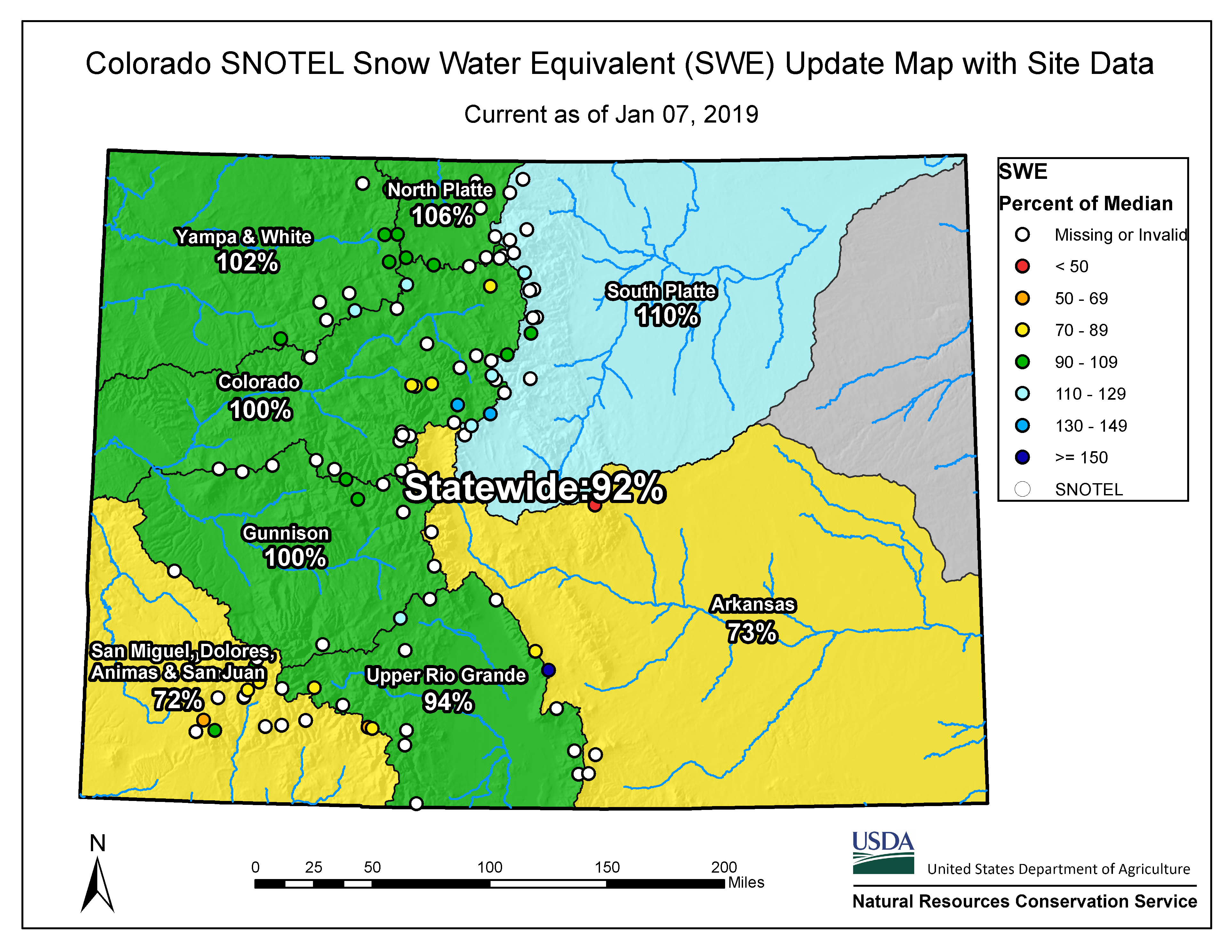
The tail end of a nice day and a half day storm is now departing the Northern San Juans. In it’s wake the 37 hour storm left close to 11″ new snow accumulation at SASP (11,060′) and slightly more at SBSP (elevation 12,180′). 19 mm (0.75″) precipitation is what we recorded at SASP. Strong S-SW winds, particularly in the Red Mountain Pass and Telluride area, periodically accompanied the storm, redistributing some of this freshly fallen snow. As of today the San Miguel/Dolores/Animas Basin is showing 72% of median, and it sure is good to see the Rio Grande in the green at 94% of median – hopefully it will only get better……..The NWS forecast is calling for a ridge of high pressure moving into place Tuesday-Thursday. Friday a weak trough moves through with models indicating this system will not bring significant snowfall. On Saturday afternoon another system might bring light flurries along the continental divide – this will pass Saturday night into Sunday. And yet another Pacific expected to move in early next week, possibly resulting in light moisture for the Four Corners ahead of a closed low. Most of this is a bit too far out to nail down. In summary the 7-day precipitation forecast maps do not look encouraging.
[br][br]
In what has become a rarity, a good bit of the National Monument/Four corners area has a little bit of snow cover (or had as of January 4). Every bit helps and if it keeps the soils wetted, inhibiting dust mobilization, then all the better.
[br][br]
On January 5 a skier was caught, buried, and killed in an avalanche in Upper Senator Beck. The skier was part of an avalanche level 2 field class with Silverton Avalanche School – not affiliated with CSAS. In all, six people were caught in the avalanche and five people made it out ok. Our condolences to family, friends, and all impacted. The CAIC will investigate the details of the avalanche and post a comprehensive report once the weather clears and they are able to access the Upper Basin. The preliminary report can be found here:
[br][br]
[br][br]
[br][br]
More soon
[br][br]
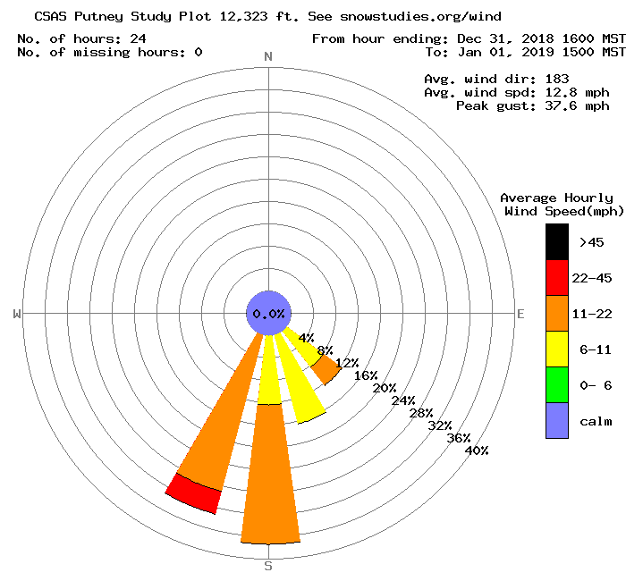
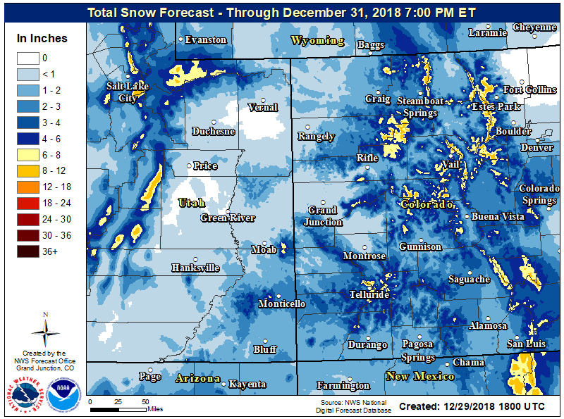
CSAS Winter Storm #7, December 31 – January 1, 2019
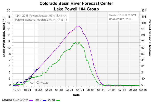
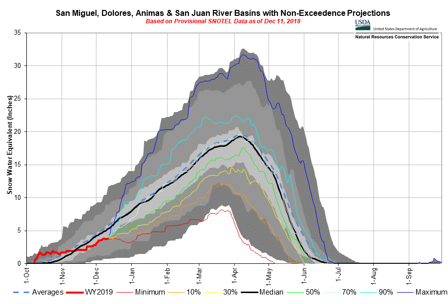
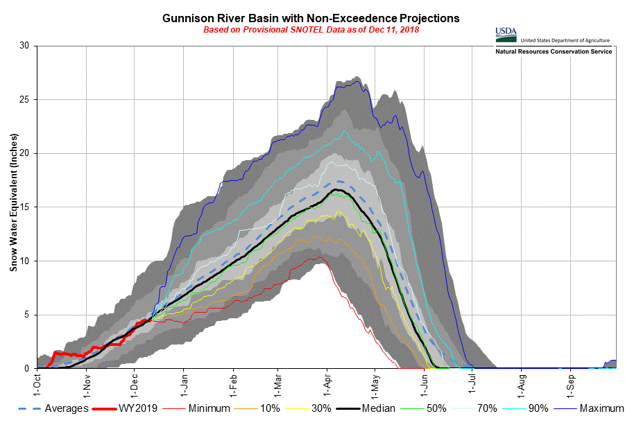
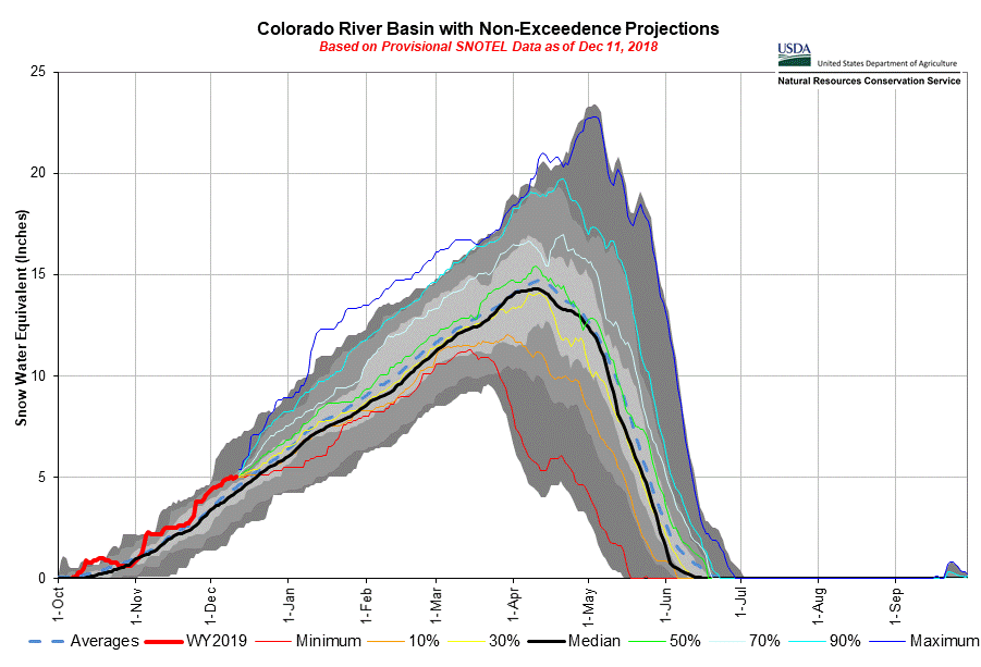
Another storm, our third in the last week, has now left Colorado. Since Christmas Eve we have received 52 mm (2”) of precipitation at SBB. Storm #7, arriving early December 31 and departed early evening January 1. This storm greatly benefitted the southern part of the state. The Upper Rio Grande and San Miguel/Dolores/Animas Basins both advanced 10% closer to median SWE.
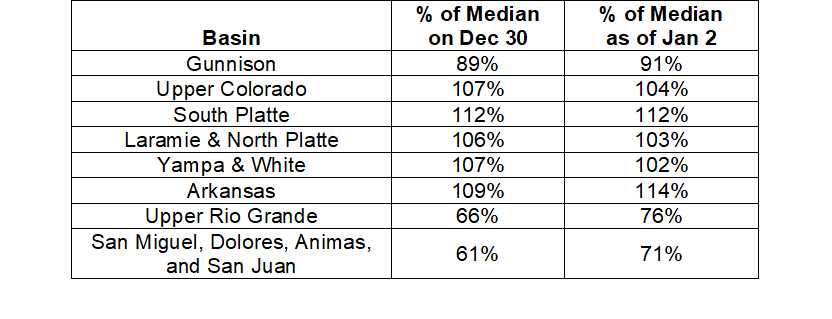
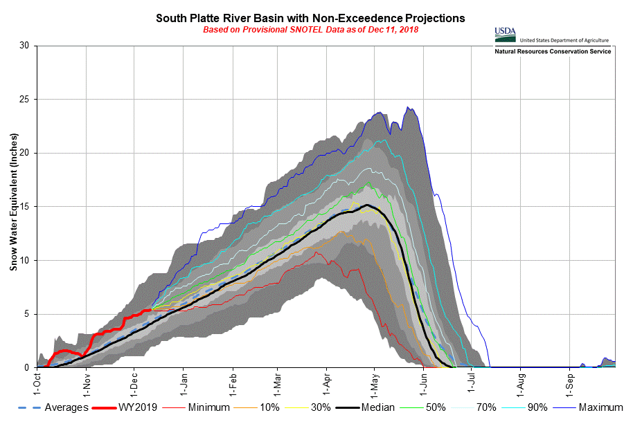
As the below plots show we have received about average precipitation (and resulting SWE) as of the end December at Red Mt Pass. But Red Mt is a bit of an anomaly as SNOTEL stations around the San Miguel/Dolores/Animas Basin are consistently showing mostly between 35%-89% of median with the Basin overall reporting 71% of median SWE. Similarly, the Rio Grande Basin received a nice bump from this passing storm and four SNOTEL’s are showing 100% of median or much better, but eight are below median with the average being 76%. The Gunnison Basin advanced 2% to 91% of median from this last storm. And thankfully the rest of Colorado’s major basins are currently above 100%. No dust-on-snow has been observed at SBB to date, and if history holds, we have not received a dust event in January in our period of record starting 2005.
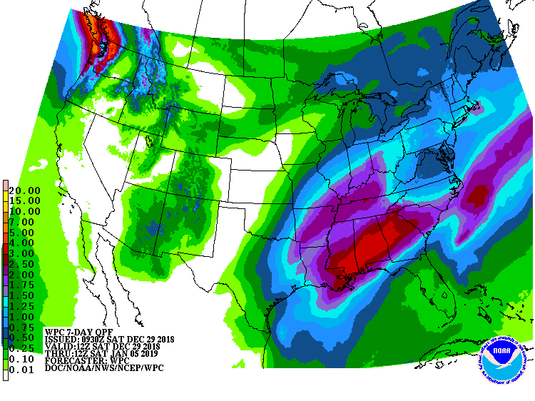
With this system having now passed, we can expect the atmosphere drying out and clear cold nights. My truck thermometer displayed -21F in Silverton this morning! A trend of warmer temperatures will continue through Saturday. A broad upper-level trough will move through Colorado next Sunday, forecast guidance with this slightly colder system for Western Colorado anticipates lower snow levels and higher accumulation throughout mountains. Preliminary guesses are for 5-10” from Sunday through Monday.
CSAS Winter Storm #5 and #6, December 24-26, 2018
Greetings from Silverton,
An active weather pattern started bringing precipitation to Southern Colorado the day before Christmas (bringing 0.47” water with 7.5” accumulation), took a 24 hour break, and began again the afternoon on Christmas Day (bringing 0.71” water with 7” additional accumulation). The current system in our area has moved along by early this morning. Another system is expected arrive midday Sunday for the Park and Gore ranges with precipitation starting Sunday night in the San Juan Mountain area and exists by Wednesday, followed by dry and cool weather through the end of the week. Please see images below.
Please see links to Storm #5 and Storm #6 Reports.
More Soon
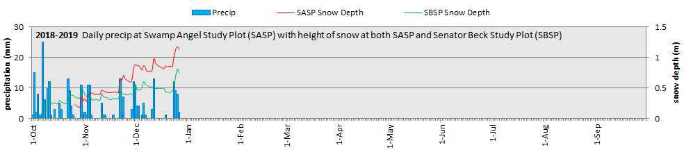
CSAS Winter Storm #4: December 13, 2018
Greetings from Silverton,
Storm #4 rolled in straight out of the north yesterday (Wednesday) afternoon with strong winds peaking at 63 mph. This north-northwesterly flow as it moved through the Ouray area caused what is called a “gorge event”. Orographic lifting produced almost 1′ of new snow accumulation in some locations between Ouray and Red Mt Pass.
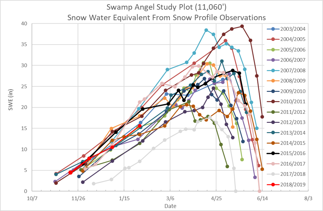
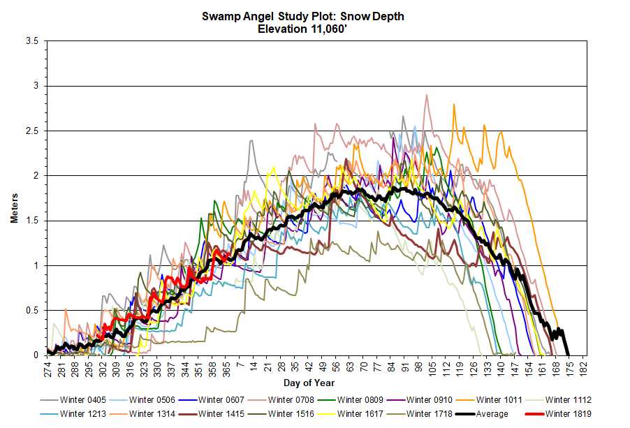
At our study basin at Red Mt Pass, snow accumulation amounted to 20 cm (7.9″) at Swamp Angel (elevation 11,060′) with total precipitation being 13 mm (0.5″). At Senator Beck Study Plot (elevation 12,200′) what snow accumulation occurred was quickly scoured away from the strong winds.
We will see cold temperatures starting to give way to warmer temps by Friday. Our next chance for snow will come about on Monday/Tuesday with the details on this one still to far out to say much about it.
If you are new to our Storm Reports, please see our websites to orient yourself as to our location and what we do:
More Soon
CSAS Winter Storm #2 and #3: December 11, 2018
Greetings from Silverton,
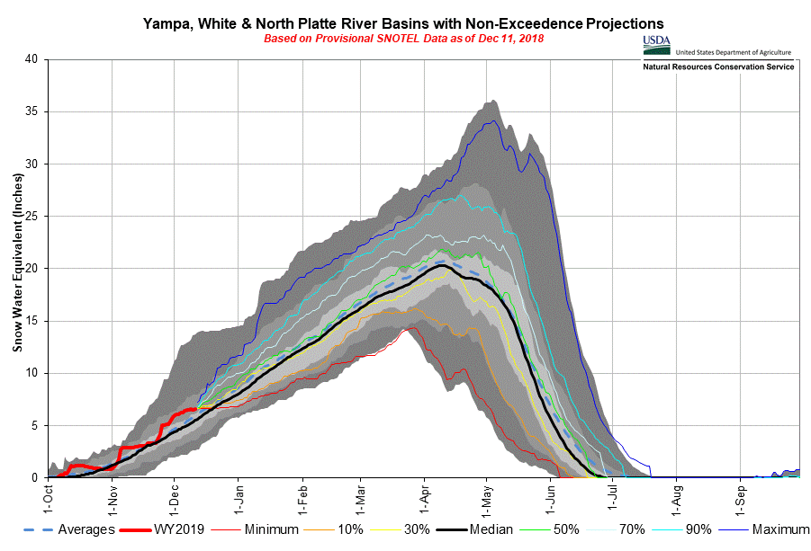
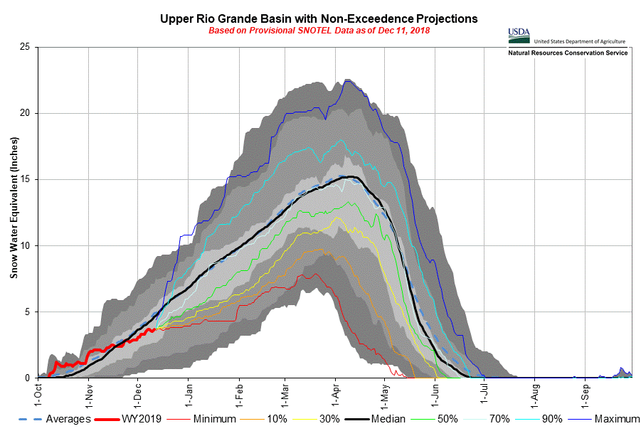
November Recap: The first 5-days of November started out nicely with 26 mm (1.0”) precipitation, which constituted Storm #1 at Senator Beck Study Basin (SBB). However the 18 days that followed we observed only 9 mm (0.35”) precipitation. Thankfully, complex multiple frontal systems came through the Western U.S. resulting in 2 significant storms systems occurring Thanksgiving Day and then two days later on November 24. The precipitation from these two events totaled 21 mm (0.83”) at SBB (CSAS Storm #2). Overall boosting Mountain snowpack 8-10%, although the Upper Rio Grande mostly missed out on this round of precipitation, only gaining 1%. But the month wasn’t over, the last day of November a low pressure trough that dipped south enough on southwest flow to give the San Juans a good shot of precipitation, 34 mm (1.3”) over a 4 day period to make it Storm #3 in the study basin.
Coming Week: The short-term forecast is calling for a weak trough to move across the area today thru tonight bringing scattered snow in the mountains. A more optimistic trough will move in Wednesday in the Northern Rockies and by the afternoon the trough will dip south with a strong jet moving over southern UT and the Four Corners region, resulting in 4” in the Northern San Juans and 1” in the Southern San Juans. By latter Thursday a ridge builds in the West keeping things dry and sunny. This ridge breaks down late Friday but the next trough is expected to stay north. But it’s nice to active weather so far this winter season, compared to last year at this time we were stuck under the wrong end of a high amplitude blocking pattern (the Ridiculously Resilient Ridge) that shut down storm activity in Colorado, and routed storms north of Colorado.
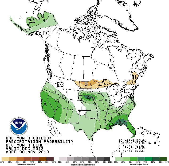
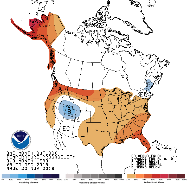
Seasonal Forecast: The current NWS seasonal forecast has 80% chance of a weak to moderate El Nino this winter and 55-60% chance of it continuing through spring. This type of El Nino (Modoki) seems to have the best analog in the 2006/07 and 2014/15 winter seasons, with 2014/15 being the better. In both years, most of Colorado was at or above snowpack by mid-winter, then crashing in late winter with most of the state having below average snowpack.
Snow School: There is still space available in our Snow School for Water Professionals, our two and half day combination classroom and field class designed for water professionals wanting to learn more about snow and our mountain systems. Please contact me with any questions.
Please see Storm #2 and Storm #3 Reports here


CSAS Winter Storm #1: November 4-5, 2018
Greetings from Silverton,
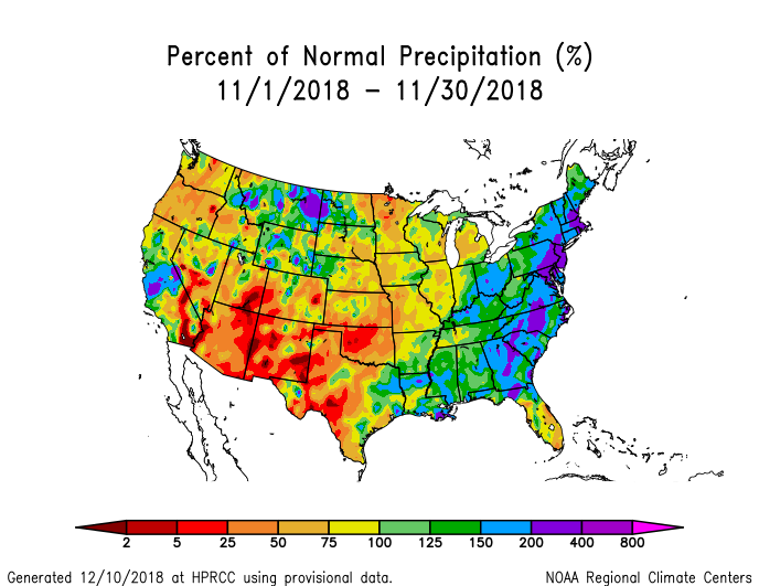
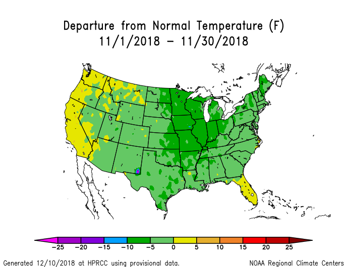
A number of active weather patterns have passed through Colorado over the last few weeks giving the Colorado snowpack a good jump on the season. In October we recorded 20 days with precipitation along with the first 6 days of November. Our first storm since we experienced permanent snowcover in the majority of Senator Beck Basin occurred Nov. 4-5. Our definition of storm, which determines when we issue a storm report, is at least 12 mm (0.47″) of precipitation with no break in precipitation longer than 12 hours. We have received a number of recent events that just fell short of meeting that threshold, such as on Nov. 3 and Oct 30 we received 11 mm (0.43″). Since the start of Water Year 2019 we have recorded 157 mm (6.2″) of precipitation (the average is closer to 4.3″). And this is the theme throughout the Colorado mountains, above average snow accumulation is laying down the base for the rest of the snow season. Unfortunately, the forecast is calling for a general drying and warming trend with any new system bringing minimal moisture, thus not much rain/snow expected.
Snow School: Please see the attached flier for details about
Snow School for Water Professionals, our two and half day combination classroom and field class designed for water professionals wanting to learn more about snow and our mountain systems. Please contact me with any questions.
[/et_pb_text][/et_pb_column][et_pb_column type=”1_3″][et_pb_sidebar _builder_version=”3.12.2″ area=”et_pb_widget_area_5″ /][/et_pb_column][/et_pb_row][/et_pb_section]


