Winter Storm Data 2015 – 2016
MOUNTAIN SYSTEM MONITORING: WINTER STORM DATA
This Precip and Storm Report Excel Workbook contains the current and past 13 seasons of CSAS winter storm data, including:
- Dates, times and duration of each winter storm event (2003-current)
- Change in the height of snow at both our alpine Senator Beck study plot and our subalpine Swamp Angel site.
- Peak gust data from our Putney site.
- Mean and maximum precipitation intensity during each storm
- Total new water accumulation in mm for each storm event.
- Summary data for each month of the season.
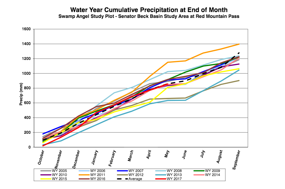
- Cumulative annual precipitation graph by month
- CSAS Storm Definition >= 12 mm SWE with no break in precipitation >12 hours
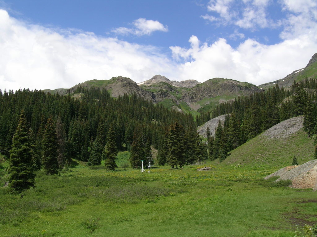
- SASP =Swamp Angel Study Plot(11,060′, in sub-alpine meadow)
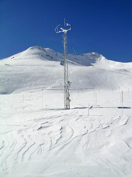
- SBSP =Senator Beck Study Plot(12,186′, on alpine bench)
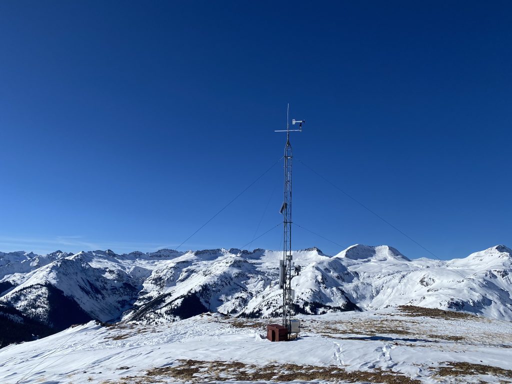
- PTSP =Putney Study Plot(12,323′ alpine ridge ‘free air’ site)
2015-2016 WINTER STORM REPORTS:
CSAS Storm #24
Greetings from Silverton,
The stormy weather over the last few days has brought Storm #24 here at out Swamp Angel Study Plot (SASP). Precipitation mostly fell as rain at SASP (11,060′) while at the Senator Beck Study Plot (12,180′) it appears to have been mostly in the form of snow. Today thru Thursday night the chance of precipitation remains 30%-70% with conditions expected to dry out later this week. A complete Storm #24 report is attached. More Soon, Jeff Derry CSAS Storm #22 and #23
Greetings from Silverton,
The active weather systems over the last few weeks have helped southern Colorado make up for the February to mid-March dry period. Over the last few days it has been cloudy with frequent rain and snow here in Silverton and at our Senator Beck Study Basin. Since Friday we have received a total 2″ of precipitation. Since April 23, we have received 4.2″ of precipitation. The precipitation has been falling as moist snow at higher elevations and rain/snow everywhere else. Storm #22 occurred Sunday, May 8 thru the afternoon on Monday, May 9. That storm event was out of the southwest and totaled 1.1″ of precipitation.Storm #23 occurred Tuesday, May 10, and was out of the W-SW. This event brought 0.8″ of precipitation. The full Storm #22 and Storm #23 Report is attached. Below is the precipitation outlook for the next 7-days. More Soon, Jeff Derry  CSAS Storm #20 and #21 at Senator Beck Basin
Greetings from Silverton,
Since Monday, April 25, Senator Beck has received a steady stream of precipitation, and, as I write this e-mail it is snowing and expected to continue through Monday, dissipating into Tuesday morning. This weeks precipitation has consisted of several back-to-back synoptic scale systems that have not allowed a break greater than 12 hours between events. It is the first time this WY2016 season this has happened. Our storm definition, at least 12mm of precipitation with no break greater than 12 hours, has been tweaked to better reflect, with hopefully a little better accuracy, the number of storm events we have been receiving. The first storm is defined as occurring from 1200 MST Monday, April 25 to 2400 Tuesday, April 26. The second storm is defined between 0700 Wednesday, April 27 to 0200 Friday, April 29. All total, from April 25-30, Senator Beck received 1.9″ of precipitation. The NWS forecasts calls for a high pressure dominating late Tuesday thru Wednesday night. The next strong low will move onshore Thursday and be in the Four Corners Regions Saturday afternoon. The full Storm #20 and Storm #21 reports are attached. More Soon, Jeff Derry CSAS Storm #19: 1.5″ Precip at SASP April 15-17
Greetings from Silverton,
The lingering state-wide Spring storm seemingly left the San Juan region a little earlier than expected, but just as I was about to send out this report for Storm #19, our Swamp Angel Study Plot received 5 mm (0.20″) of precipitation and 10 cm (4″) of addition snow accumulation. The official storm occurred April 15-17. High winds out of the SW ushered in the storm in some areas of the State but as of right now we are reasonably sure a new dust event did not accompany. The official precipitation total is 38 mm (1.5″), if we include all the spits of moisture received outside the storm duration, the precipitation received at SASP is 44 mm (1.7″). SASP accumulated 33.5 cm (14″) of snow and SBSP 29.4 cm (11.6″). A nice dose of precipitation, most definitely needed especially in the Southern Basins. Hopefully we’ll see a few more of these events before winter completely bids us farewell. Storm Report #19 is attached. More Soon, Jeff Derry CSAS Storm Report #18
Greetings from Silverton,
Storm #18 officially came through Senator Beck Basin starting between 1500-1600 on Monday, March 28 thru 400 Wednesday, March 30. The storm was preceded with strong S’ly winds and high winds continued while the snow fell. The first 28 hours of the storm the average hourly gust was 63 mph, creating real blizzard like conditions at times in Silverton and surrounding areas. We received 9.7″ (24.7 cm) of new snow accumulation and a solid 1.0″ (25 mm) of precipitation. On Wednesday, March 30, around 7:00am the winds shifted out of the North. We continued to see another 0.24″ (6 mm) of precipitation until late Thursday night, but there was a gap of precipitation greater than 12 hours thus ending the official duration of the storm. The week to come looks pretty tame with only a 20% chance of precipitation in the Silverton area, snow showers, in the 2-5″ range look to favor the north and central mountains. The full Storm #18 Report is attached. More Soon, Jeff Derry CSAS Storm Report #17
Greetings from Silverton,
Friday night through most of Saturday we received 6″ of new snow accumulation and 0.7″ (19 mm) of precipitation. Not much but we’ll take it. Winds were out of the WNW-NNE. A full report for Storm #17 is attached. Looking ahead……A cold front preceded by gusty winds is expected to come into western Colorado Monday and Tuesday. The system is creating wind and dust advisories for many areas including SW Colorado and possibly Grand Valley. The forecast calls for areas of blowing dust starting Monday going into Monday night. Snow is expected to start Monday night and go into Wednesday. 4 to 12 inches are possible for the mountains of western Colorado. More Soon I Hope, Jeff Derry CSAS Storm #16: March 22-23
Greetings from Silverton,
A couple days ago we hit Storm #16 here at Senator Beck Basin. On Tuesday, March 22, the storm started out of the SW bringing light dust to Senator Beck and heavier amounts of dust to the eastern San Juan Mountains. The wind then shifted out of the WNW to N and it began snowing until 1900 on Wednesday, bringing 12.6″ (32.1 cm) of new snow to our now 5.2′ (1.57 m) snowpack at SASP. Please see a full report attached. More soon, Jeff Derry CSAS Storm Report #15: March 6-8
Greetings from Silverton,
Our first storm of March WY2016 moved east of our Study Basin early this morning. This was a wet two day storm with average 17 mph winds (peak gusts up to 72 mph) out of the SSW. The NWS indicates a closed low over Mexico will move through today/tonight with a forecast of scattered precipitation and isolated heavy bursts of snow above 9,000′. The next 7-10 days is expected to bring an unsettled pattern with a closed low just south of the Four Corners Saturday/Sunday bringing some precipitation to our area and next week (Monday/Tuesday) we are to expect a long wave trough bringing widespread showers, it is still unclear as to the intensity and extent of these systems. Storm #15 Report is attached. More Soon, Jeff Derry CSAS Storm Report #14
Greetings from Silverton,
Quick moving Storm #14 came through the Senator Beck Study Area starting Monday morning and passed Tuesday afternoon. The Storm brought 21.1 cm (8.3″) of new snow accumulation, enough to cover D2, the second dust-on-snow event for WY2016, for the time being. Winds were pretty calm and out of the NNE for the duration. A persistent ridge has settled over the area bringing a dry warming trend. The next chance for precipitation is not until Monday/Tuesday. Storm #14 Report is attached. More Soon, Jeff Derry CSAS Storm #13 at Senator Beck Basin
Greetings from Silverton,
Productive Storm #13, lasting 82 hours, ended yesterday afternoon. We received 55 mm (2.2″) of water content at SASP. Wind direction was out of the S-SW for the bulk of the storm, with speeds consistently 22-45 mph, and shifted out of the north on the last day. With the passing storm we now have frigid temperatures in the minus 20’s (Celsius) at night and in the minus high teens during the day. The complete Storm #13 Report is attached. More Soon, Jeff Derry CSAS Storm #12 at Senator Beck Basin
Greetings from Silverton,
Yesterday evening Storm #12 came to an end. This was a 34 hour storm that brought 24 mm (0.9″) of water content to SASP. Average wind speeds of 7 m/s (15.7 mph) were out of the NW to NNE for the duration of the storm. For the month of January alone, we have received 76 mm (3″) of precipitation. Our YTD total is now up to 518 mm (20.4″) of cumulative precipitation at SASP. A complete Storm #12 is attached. More soon, Jeff Derry CSAS Storm #11: 1-Day Wallop
Greetings from Silverton,
Yesterday, Wednesday January 20, we experienced a quick moving storm system passing through the San Juan Mountains. In 22 hours it brought 17 mm (0.7″) of water equivalent and 17 cm (6.7″) of new snow to Swamp Angel Study Plot near the summit of Red Mountain Pass. Storm #11 Report is attached. Today is a blue bird day with the wind wisping the snow over and around the peaks. More Soon, Jeff Derry CSAS Storm Report #10
Greetings from Silverton,
On Sunday at 3:00pm, Storm #10, lasting 59 hours, ended bringing 35 mm (1.4″) of water content to Swamp Angel Study Plot. I was expecting to compile the Storm Report on Sunday, but the precipitation kept coming until late Sunday afternoon. The storm systems that passed through brought 12 mm of precipitation on Friday, 10 mm on Saturday, and 13 mm on Sunday. Starting on Saturday at 3:00pm thru Sunday at 9:00am, average wind speeds kicked up to 13 m/s (29 mph), with average peak gusts of 19 m/s (43 mph), and max peak gust of 27 m/s (61 mph), redistributing the freshly fallen snow most noticeably in terrain above treeline. A complete Strom #10 Report is attached. Jeff Derry Winter Storm #8 and Storm #9: December 19-25, 2015
Greetings,
As we all know, the Colorado mountains, including Senator Beck Basin and Red Mountain Pass, received a very nice bump in snow accumulation over the last 7 days. By definition (at least 12 mm of precipitation with no more than 12 hours without recorded precipitation), we saw two storms pass through since December 19. The first storm event occurred December 19 through December 23. After approximately 15 hours, Storm #9 moved in December 24-25. Precipitation totaled over 4″ of water equivalent for both storms with 30″ of new snow at SASP – This was a major event. Winds were strong (particularly for Storm #9) out of the S thru W-NW with gusts greater than 60 mph. Even with a fair amount of wind erosion, 20″ of snow accumulated at SBSP (12,180′). This Tuesday morning another system is expected to pass the four corners region, bringing an increasing chance for snow, although significant accumulation is not expected with this system. A complete report for Storm #8 and Storm #9 is attached. Happy Holidays, Jeff Derry CSAS Storm #7 Report: December 14-16
Greetings,
34 hours after Storm #6 (December 11-12) ended, storm #7 rolled into town for 41 hours and delivered 25 mm (1 in) of precipitation, officially ending Wednesday at 1:00 am. Total precipitation received over the last 7 days is 50 mm (2 in), and we now have 1 meter of snow at SASP. A complete Storm #7 report is attached. Take Care, Jeff Derry CSAS Storm #6 Report
Greetings from Silverton,
Storm #6 began late Friday, December 11 and ended Saturday, December 12. Lasting only 24 hours and delivering 17 mm (0.7 in) of precipitation. We are likely going to see another storm this week, the forecast calls for 6-12″ of new snow accumulation. A complete Storm #6 report is attached. More Soon, Jeff Derry Winter Storm #5: November 15-17, 2015
Greetings from Silverton,
It’s a calm (29 F) and partly sunny day here in Silverton. Storm Report #5 is attached for winter 2015/2016 thus far. This Storm started with some intensity for the first 8 hours and then tapered to mostly 1-3 mm/hr of precipitation for the remaining 24 hours. This was a significant precipitation event with a total gain of 54 mm (2 inches) of water content at SASP. Snow depth at SASP increased 53 cm (21 inches), and 31 cm (12 inches) at SBSP. This storm had periods of high peak gusts and periods of high sustained winds. See the variable SBSP snow plot (above treeline) compared to the SASP (below treeline) in the attached pdf. For three hours early Monday (Nov 16) morning gusts ranged from 23-41 m/s (52-91 mph) from the S-SW. Then, for 17 hours beginning at 2100 on Monday, peak gusts were sustained between 14-22 m/s (32-50 mph), with average gusts for this time period of 19 m/s (42 mph), from the N. Our Water Year total precipitation is 236 mm (9 inches). We are above the 11 year average of 191 mm (7.5 inches) collected by the end of November. More Soon I Hope, Jeff Derry CSAS Storm #4
Greetings from Silverton,
Storm #4 came between 1500-1600 hrs MST Tuesday, November 10 and left 1600 hrs MST Wednesday, November 11. SASP snow depth increased 24.4 cm (9.6 inches), current total snow depth is 45 cm (17.7 inches). SBSP was wind affected gaining only 1.3 cm (0.5 inches) of snow. The storm brought approximately 18 mm (0.7 inches) of precipitation. A pesky spruce needle got stuck in the check-valve of the precipitation gauge, so precipitation totals were reconstructed using nearby SNOTEL data. A complete Storm #4 report is attached. Take Care, Jeff Derry Building the Snowpack – Storm #3
Greetings from Silverton –
Last week we saw Storm #3 which started late evening Tuesday and ended early eveningThursday. A power failure resulted in a data glitch, delaying the creation of this report. Storm #3 totaled 36 mm (1.4″) of water content, our water year total precipitation is now 163 mm. Rather high winds accompanied this storm with average speeds of 20 mph with gusts up to 67 mph. Swamp Angel (elevation 11,060′) saw the snowpack increase 34 cm (13.5″). Senator Beck (elevation 12,180′) saw an increase of 24 cm (9.4″). The forecast is for a fast moving storm to move in late this afternoon. Snowfall is expected to increase and peak overnight/tomorrow morning, and exit the area by Wednesday. Anticipated snowfall will be half a foot to over a foot. You will likely be seeing another CSAS storm report soon. Attached is a PDF with Storm #3 details. More soon, Jeff Derry Snowcover begins in Senator Beck Basin Greetings from Silverton – Over the past week the western San Juan Mountains have begun developing the Winter 2015/2016 snowpack. Two back-to-back storms, recorded as CSAS Winter Storms #1 and #2, have produced enough snowcover to persist over at least 50% of Senator Beck Basin henceforth, even if we have a subsequent dry and sunny period. Storm #1, October 18-20, fell as mixed precipitation at Swamp Angel Study Plot (11,060′), without any accumulation of snow, but did fall as primarily snow at the higher Senator Beck Study Plot (12,180′). Storm #2, October 22-23, fell as snow at both study plots. Neither Storm was particularly intense, with only moderate winds and precipitation intensity. CSAS looks forward to receiving a more normal quota of Winter Storms here in the San Juan Mountains this season, at somewhere around 25 total storms, as opposed to the poor total of only 18 Winter Storms last season. We will soon (in early November) be adding a new chart of “Cumulative Winter Storm Count” data to our graphed precipitation webpage
