Winter Storm Data 2016 – 2017
MOUNTAIN SYSTEM MONITORING: WINTER STORM DATA
This Precip and Storm Report Excel Workbook contains the current and past 13 seasons of CSAS winter storm data, including:
- Dates, times and duration of each winter storm event (2003-current)
- Change in the height of snow at both our alpine Senator Beck study plot and our subalpine Swamp Angel site.
- Peak gust data from our Putney site.
- Mean and maximum precipitation intensity during each storm
- Total new water accumulation in mm for each storm event.
- Summary data for each month of the season.
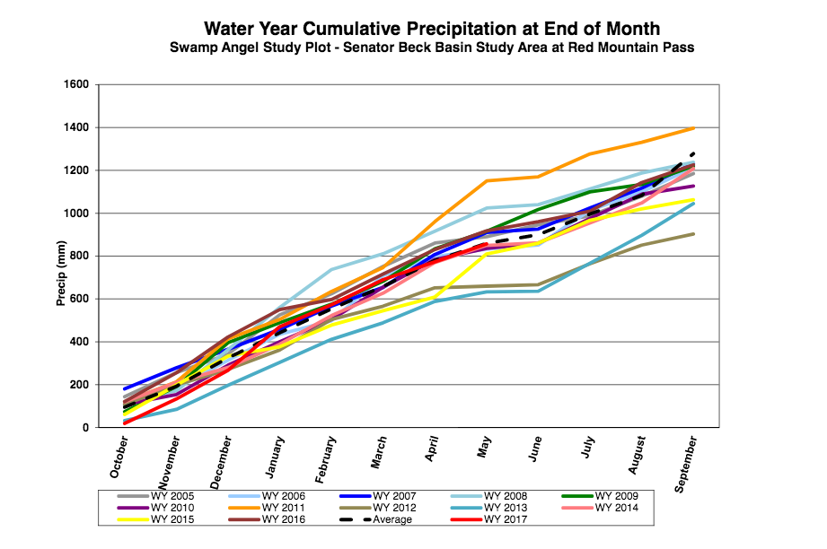
- Cumulative annual precipitation graph by month
See our Current Conditions for the latest hourly data. All times shown are in Mountain Standard Time (MST)
- CSAS Storm Definition >= 12 mm SWE with no break in precipitation >12 hours
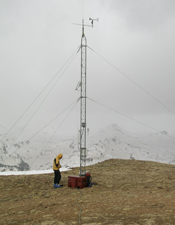
- SASP =Swamp Angel Study Plot(11,060′, in sub-alpine meadow)
- SBSP =Senator Beck Study Plot(12,186′, on alpine bench)
- PTSP =Putney Study Plot(12,323′ alpine ridge ‘free air’ site)
2016-2017 WINTER STORM REPORTS:
Storm Report #28: Rain on Snow Last Night Greetings from Silverton, Last night starting at 7 pm we received 0.47″ (12 mm) of precipitation over a 5 hour period at SASP. Judging by the air temperatures and lack of snow accumulation not only did it rain at SASP (11,060′) but also SBSP (12,186′), or at least came down as very wet snow. Air temperatures at SASP were warm, during the storm minimum hourly temps ranged 1-5 degrees C at SASP, and -0.2-3.5 degrees C at SBSP. As mentioned in the CODOS Update yesterday, when air temperatures begin to stay above freezing at night, the upper ~9″ of the snowpack does not re-freeze, with no energy required to go into the snowpack the next day to bring it up to the melting point, snowmelt essentially begins where it left off the day before. And indeed, warm daytime temperatures the last few days and also above freezing minimum temperatures the last few nights have kicked streamflow into action. Yesterday streamflow at Senator Beck slowly ramped up from 8 cfs in the morning to 16 cfs by 3 am this morning, undoubtedly aided by the fast moving, and high intensity storm (max intensity of 5 mm in one hour). Currently, flows have receded to 13 cfs. 
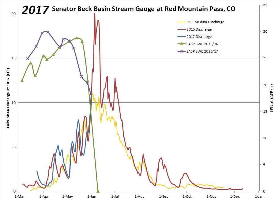 Please see attached Storm Report. More soon. CSAS: Winter Storm #27 Greetings from Silverton, A very productive spring storm (number 27 for the season) impacted the entire state this past week. Here in the San Juan Mountains we picked up 36.8cm (14.5 inches) of new snow at our Swamp Angel Study Plot in Senator Beck Basin. 35mm (1.4 inches) of precipitation was associated with this snow. The warm weather that has been typical of this spring, with a few stormy periods, took a toll on the snowpack in the past weeks. Even though this storm brought a nice boost, we are now well past peak SWE at 11,000 feet in the Basin. Perhaps more important though is the covering of a significant layer of merged dust events, which had emerged prior to this storm. When the dust is on the surface it contributes to the acceleration of the melt season. We have received a nice “albedo reset” to slow down the melt. With warm temperatures and sun in the forecast for the rest of the month it is difficult to say just how long the dust will remain covered. As of now the forecast doesn’t show any significant precipitation in the next 7-10 days. See the full storm report attached below. More from Silverton soon. CSAS: Winter Storm #26 Greetings from Silverton, After a two-week break from major winter storms the atmosphere turned the faucet back on over Colorado. From May 9-11 the Senator Beck Basin picked up 29mm (1.1 inches) of precipitation as measured at the Swamp Angel Study Plot (SASP). This came as only 13.2cm (5.2 inches) of snow, indicating wet spring flakes and notable settlement during the 47 hour-long storm. The past week of very warm weather, which included two consecutive non-freezing nights at 11,000 ft. and saw re-emergence of two significant dust layers (D3 and D4) resulted in losses in snow height and snow water equivalent (SWE) in our snowpack. This storm did not add much in snow height, but brought SASP total SWE back up to near its level from before the warm spell. For the time being, those pesky dust layers are back under the nice white new snow. While it is still looking very much like winter at high elevations, the foreseeable future is looking warm and sunny, and with only a few inches of snow between the dust and the surface our snowpack may be dirty again soon. With a primarily isothermal snowpack at 11,000 ft. and a dusty surface on the way we expect to see the melt, which was put on hold during this past storm, to return. Keep an eye on our rivers for spikes in runoff, and expect more melt at higher and higher elevations as we move into the warmer spring period. See the attached storm report below. More from Silverton soon, Jeff Derry CSAS: Winter Storm #25 Greetings from Silverton, Winter Storm 25 was a piece of a large low-pressure system which passed through Colorado during the second half of last week. By our definition, this storm lasted 19 hours, leaving 15.7cm (6.2 inches) of snow at Swamp Angel Study Plot in the Senator Beck Basin study area. 15mm of precipitation total was recorded, all as snow. The higher elevation Senator Beck study Plot saw less than an inch of gain in snow height, likely due to redistribution by strong winds. After this winter storm ended (12 or more hours without new precip recorded) another pulse of precipitation brought 10mm more water to Swamp Angel. This did not meet our minimum 12mm precipitation threshold, but the notable point here is that this low-pressure system delivered 25mm (1″) of precipitation before moving east of the Rockies. The last 10 days of April we received a total 2″ of precipitation. Light instabilities persist over the San Juan Mountains, but will give way to very warm temperatures for the remainder of the week and weekend. Starting next week, we will see some cooling and chance precipitation. CSAS will be on the road over the weekend conducting our 3rd CODOS tour of the season, assessing dust and snowpack statewide. Look for our report on this upcoming tour at the beginning of next week, along with a pre-trip CODOS update, which will be out tomorrow. The full storm #25 report is attached. More from Silverton soon, Jeff Derry CSAS: Winter Storm #24 Greetings from Silverton, Winter storm 24 broke our April dry spell, bringing moderate precipitation to the Senator Beck Basin. Swamp Angel Study Plot picked up 17mm (.7 inches) of precipitation with 9.7cm (3.8 inches) of gain in snow height. However, some of this precipitation likely fell as rain early in the storm, and thin rain crusts were found within this new snow at the study plot yesterday. High winds and haze were observed in the San Juan Mountains prior to this storm, but no significant dust was recorded in our study basin. If dust was deposited on the snow surface prior to the storm, it was indistinguishable from our two events that were merged on the surface at the time, and likely a minor contribution to total dust for the season. There is significant dust in the snowpack at the Senator Beck Basin, much of which was exposed prior to this winter storm. This new snow, while not a major storm event, is providing an albedo reset for the region, burying the exposed dust, as well as insulating our isothermal snowpack and slowing springtime snowmelt. Our next winter storm has already begun, and is forecast to be a more significant system. Like storm 24, this incoming pulse of precipitation will likely favor the northern and eastern mountains of Colorado, but several inches of snow are expected in the San Juans as well. Weather will remain stormy on and off through the middle of next week before spring returns. Please see storm report attached. More from Silverton soon. Jeff Derry CSAS Winter Storm #23
Greetings from Silverton,
Our 23rd winter storm of the season was a productive system which deposited 20mm (0.8 inches) of precipitation in Senator Beck Basin in the San Juan Mountains of Southwest Colorado. This came as 26.6cm of low density snow. This system came predominately from the north and brought cold temperatures that contributed to the light, fluffy quality of the fallen snow. The storm came in without any dust, thankfully burying our three existing dust layers deeper in the snowpack. To continue the trend of the past few weeks, we have moved into another short lull in the storms. High pressure and clear weather will characterize the next few days and another stormy period is expected to begin this weekend as more moisture moves in from he Pacific. CSAS will be on the road this weekend for our second CODOS tour of the season, when we will assess the snowpack and current distribution of dust statewide. Look for a report on these observations early next week. Please see the full Storm #23 Report attached. More from Silverton soon. Jeff Derry CSAS Winter Storm #22
Greetings from Silverton,
Winter Storm #22 turned into an April fools joke that dragged on a little too long. With several long breaks that didn’t quite meet our threshold of 12 hours without precipitation to end the storm, this system persisted longer than anticipated with far less precipitation than forecasted. All told, over 57 hours the Swamp Angel Study Plot in Senator Beck Basin gained 17mm (0.7 inches) of precipitation as only 4.5 cm (1.8 inches) of snow. Because this storm was so long the new snow had ample time to settle throughout the storm, resulting in meager gains in snow height for the amount of water. This storm was forecast to be a major event for the San Juan Mountains in Southwest Colorado, as well as for the rest of the state. However, once the low-pressure system inched up into the Four Corners region, it was cut off from the jet stream. This unfortunately split its moisture into a meandering system that stumbled to our south and a more direct jet-driven pulse north towards Wyoming. Precipitation in Colorado was general seen in short bursts with long breaks and lower than expected snow totals. Some areas lucked out on highly zonal flow and picked up as much as 18 inches, but generally snow totals were only 3-6 inches statewide. Adding to the disappointing snow totals, the onset of this storm was accompanied by our third dust event of the season. D3 is a diffuse but highly visible layer, incorporated into the first inch of snow from Storm 22. We released a Dust Alert yesterday regarding this event. We will also be conducting our second CODOS tour in the next week, examining the extent of this season’s dust events statewide. Look for a report early next week. The weather has again begun to destabilize as another system moves into the region, and we expect to receive our next winter storm over the next few days. The full
Storm #22 Report is attached.
More from Silverton soon- Jeff Derry CSAS Storm #21, and another on the way
Greetings from Silverton,
Storm #21 (March 28-29) was just the remnants of Storm #20 (March 27-28). Please see the full
Storm #21 Report attached.
Another strong low-pressure system is moving our way and expected to be over the Four Corners early Friday morning. This system could bring over 16″-18″ to mountain areas. Expect another storm report soon. Below is where we stand for SWE at SASP. After this approaching storm we will be competing with WY2008 for the most SWE, for this time of the year. 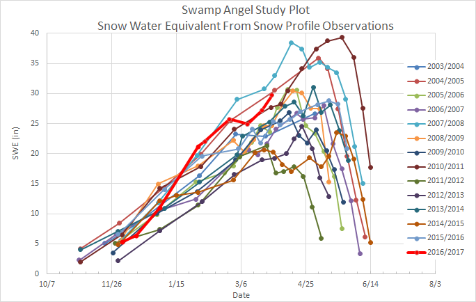 More from Silverton soon- Jeff Derry CSAS Winter Storm #20
Greetings from Silverton,
Since Thursday, March 23, a series of productive, quick moving storms have given our Storm Report Department a lot of OT, with more to do before April based on the forecast. More precipitation is expected in the northwest San Juans tonight but since we have had a solid gap of precipitation greater than 12 hours, Storm #20 has officially come and gone. Last night Storm #20 started at 1800 and ended at 0200. We received another 9.2″ of snow accumulation and 0.7″ precipitation at SASP. The storm direction (mostly out of the south-southeast of all places) and milder wind speeds allowed almost as much snow accumulation at SBSP (8.4″). To keep the tally going, since March 23 we have received 35″ new snow accumulation and 3.1″ of precipitation at SASP. As a reminder, if you want to read old storm reports, you can find these on our snowstudies webpage:
https://snowstudies.org/storms.html. You may find the “Precip and Storm Report” spreadsheet on the webpage informative.
The full Storm #20 Report is attached. More from Silverton soon- Jeff Derry CSAS Winter Storm #19
Greetings from Silverton,
Winter storm 19 was a shorter-wave follow up to our last very productive winter storm. Quick on the heels of Storm 18, this most recent pulse brought steady overnight precipitation this past weekend, depositing 18mm (0.7 inches) of precipitation at the Senator Beck Basin as 20.8cm (8.2 inches) of snow. Since March 23 (Storm 18 + 19) we have received 2.4″ of precipitation and 25.8″ of total snow accumulation at SASP. Fortunately, it does not appear any dust came in with this storm, as it had for the prior two systems. Hopefully this storm can continue to serve as a nice “albedo reset,” burying dust layers deeper beneath the white surface and slowing down our recent accelerated melt. Our current weather pattern, delivering moisture from the north and west, will be back at it in no time. Weather models are currently in good agreement and suggest a barrage of short to medium wave troughs continuing to impact the state into the forecast-able future. The next system should arrive overnight Monday or early Tuesday morning and persist through Wednesday. Please see the full
Storm #19 report attached.
More from Silverton soon, Jeff Derry CSAS Winter Storm #18
Greetings from Silverton,
Winter storm #18 was a much-needed whopper. In only 26 hours the Senator Beck Basin in the San Juan Mountain of Southwest Colorado picked up 42mm (1.7 inches) of precipitation as 44.8cm (17.6 inches) of snow. This equates to a mean precipitation intensity of an impressive 1.62mm/hr for this storm, with a maximum hourly precipitation of 5mm! However, this storm also appears to have come in alongside our second dust event of the season (D2), which is now mixed with and lying under the thick, wet blanket of new snow. Leading up to this event model accuracy was limited and forecasted snow totals were all over the place. Fortunately we hit the jackpot, bringing in upper end quantities of precipitation and far outperforming the rest of the state. This forecasting difficulty is not atypical for northern events such as this one (see wind rose in attached storm report). The majority of our major precipitation events come from the Southwest through Northwest. Up until this storm March has been delivering record high temperatures and one emerged dust event. These factors have contributed to an unprecedented warming of the snowpack, leading to the earliest date of isothermal snowpack in our 11-year record (March 22nd). Accompanying this warming of our snowpack was a major surge in regional rivers and creeks. Below is a hydrograph for the month of March for the Uncompahgre River down stream of Senator Beck Basin, showing our above average discharge, as well as the decrease in flow accompanying this storm event. 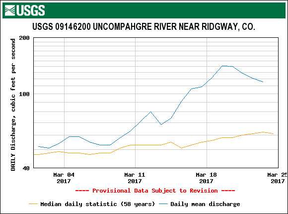 The good news is that this storm event will slow down the process of “snowpack ripening” which contributes to loss of snow as liquid water. Additionally, we are at the onset of a pattern shift, which is expected to deliver several more pulses of unstable weather for the rest of the month and into early April. On Saturday, March 25th we received Storm #19, standby for that report. Please see the full
Storm #18 report attached.
More from Silverton soon, Jeff Derry CSAS Winter Storm #17
Greetings from Silverton,
Winter storm 17 barely tipped the bucket, delivering just 12mm (.5 inches) of precipitation to the Swamp Angel Study Plot in Senator Beck Basin as 12.5cm (4.9 inches) of snow. Strong southwest winds during the event redistributed nearly all of this snow above tree line. The high elevation Senator Beck Study Plot saw only a 0.3cm (0.1 inches) gain in snow depth during this event due to this significant wind transport. No dust has been observed in the snowpack in the San Juan Mountains, but reports of a potential dust event near Crested Butte have come in. These reports are spotty, however, regional wind trajectories suggest that it is possible for dust to have been transported from source regions in Northern Arizona to the Crested Butte area while the San Juan Mountains experienced more localized ground-level winds. Additionally, blowing dust was observed in Northeastern AZ over the weekend. Below is a figure generated by the HYSPLIT model (http://ready.arl.noaa.gov/HYSPLIT.php) showing 12-hour potential suspended particle trajectories centered around the time that blowing dust was observed in AZ and ending at the Senator Beck Study Plot (southwestern star) and the Park Cone SNOTEL (northeastern star) sites. That time also roughly coincides with the start of this winter storm, and it is common for a “wet” dust event to arrive around the onset of snowfall. You can see that while the Senator Beck Basin is not indicated to have been the destination for any long-range transport, the Park Cone site could have been a deposition zone. There is no substitute for going out and digging a hole in the snow. CSAS will be conducting the first statewide CODOS tour early next week, when we will assess the snowpack for potential dust deposition and evaluate the current state of the snowpack. Please see the full
storm report attached.
More from Silverton soon, Jeff Derry 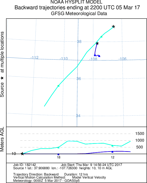 CSAS Winter Storm #16
Greetings from Silverton, Over 40 hours the Senator Beck Basin in the San Juan Mountains received 24mm (.9 inches) of precipitation as 24.1cm (9.5 inches) of snow. The storm pushed our already deep snowpack soundly over the 2-meter mark. The Basin is sitting well above average for snowpack for this time of year.
This storm deposited snow erratically across the San Juans, with highly varying storm totals in a relatively small area. Wolf Creek and Silverton Mountain are both reporting 30-inch storm totals, and telluride is reporting 20 inches. Winds at Putney Study Plot during this event were from the Northwest and Southwest, with very little west wind. We are expecting a dry spell for the beginning of march with the chance for some precipitation coming in around Monday the 6th. The next significant snowfall in Southwest Colorado is expected at the end of next week. Yesterday we released our annual March 1st snowpack update, addressing snowpack conditions in Senator Beck Basin and statewide, as well a projections for the rest of the snow season. It is available here: http://www.codos.org/codosupdates/mar12017. See the attached storm report for Winter Storm #16. More from Silverton soon- Jeff Derry CSAS Winter Storm #15
Greetings from Silverton,
Winter storm #15 was the latest in a series of moderate precipitation events to impact the Senator Beck Basin in the San Juan Mountains. Over 42 hours the Swamp Angel Study Plot received 20 mm (.8 inches) of precipitation as 18.7 cm (7.4) inches of snow. The wind affected Senator Beck Study Plot gained 12.9 cm (5.1 inches) of snow. There is more snow in the forecast for the next few days, and then the beginning of March looks to be dry for now. Forecasts for these upcoming pulses of precipitation are variable, but will likely be similar events to our past few moderate snows. Our snowpack in Senator Beck Basin is currently well above average for this date, with no observed dust layers. On March 1st we will issue a comprehensive report on the state of our snowpack in the Senator Beck Basin and in other watersheds statewide. The full
storm report is attached.
More from Silverton soon- Jeff Derry CSAS Winter Storm #14: Possible Dust
Greetings from Silverton,
Storm 14 rolled through the San Juan Mountains this past weekend leaving 17.5 cm (6.9 inches) of snow with 17mm (.7 inches) of water at the Swamp Angel Study Plot in Senator Beck Basin. The more wind affected Senator Beck Study Plot saw 24.3 cm (9.6) inches of new snow. This was the most recent storm in a series of light to moderate producers to strike the region. Storm 14 came mostly out of the south, and reported snowfall across the San Juan Mountain Range was variable. While the storm ended on Sunday evening, lingering precipitation through Monday deposited an additional 7mm of water, which is not reflected in this storm report. While the Senator Beck Basin has not seen a major storm event since the end of January, this incremental loading continues to build our snowpack. The Basin is well above average for mean snow water equivalent (SWE). This trend is similar throughout Southwest Colorado. We have had reports of a dust event preceding this storm, although we have not observed dust in the snowpack at SASP, we are ascertaining the possibility of an unevenly distributed event. If you have observed dust-on-snow, and feel it is not from a local source, please send me an email and a picture would be great. The
Storm #14 Report is attached.
More from Silverton soon- Jeff Derry CSAS Winter Storm #13
Greetings from Silverton,
Storm #13, occurring February 7-8, did not deliver the snow totals as predicted at SBB. We were expecting about 1′ of new snow but Swamp Angel received only 15 mm (0.6″) of precipitation and 5.2 cm (2″) of new snow accumulation (with a good amount of graupel). There was a 15 hour period where winds speeds gusted 50-80 mph out of the west/northwest. And warm, the first 5 hours maximum air temperatures were just barely below 0 C, with the remainder of the storm averaging -2.3 C. Today is a beautiful day. The next low pressure arrives Friday night, with the forecast to bring precip into Sunday. The Storm #13 Report is attached below. More from Silverton soon, Jeff Derry CSAS Winter Storm #12
Greetings from Silverton-
A short wave trough moved in on the heels of our last long and productive winter storm, and lingering precipitation tipped the scales giving us another recordable storm event. Winter Storm #12 lasted 42 hours and delivered 16mm (0.6 inches) of precipitation to the Senator Beck Basin in the San Juan Mountains. A notable oddity about this storm was a loss in snow height during the storm of 1.5 cm (0.6″). Because Winter Storm #12 began only 12 hours after the previous storm, the new snow was still in a period of settlement. With low precipitation intensity, Storm #12 was unable to deliver new snow as fast as the old snow settled, resulting in a gain in snow water equivalent yet a loss in total snowpack depth. With this last little pulse departing the region. The weather has turned dry and cold. Temperatures will rise in the next few days but a long wave ridge will deliver sustained stable weather well into next week. Enjoy the sunshine. Recap of December and January December and January were productive months for snow at the Senator Beck Basin Study Site. Snowpack is well above average for this time of year. No dust has yet been observed in the Senator Beck Basin. December brought 17 out of 31 days of precipitation and 4 winter storms. During the month 134mm (5.3 inches) of precipitation was recorded. January was a very wet month with 22 out of 27 days (so far) with recorded precipitation, with 5 winter storms delivering a total 203mm (8.0 inches) of precipitation to the basin. Current snowpack at the Swamp Angel Study Plot is just under 2m (6.6′), and year to date precipitation is 470mm (18.5″). A complete Storm #12 Report is attached below. More from Silverton soon, Jeff Derry CSAS Winter Storm #11
Greetings from Silverton-
The past week has seen multiple systems impact the San Juan Mountains in Southwest Colorado. Three individual pulses of unstable weather associated with an overarching low pressure system brought snow to the region. The first of these pulses brought only 8mm (.3 inches) of water to Senator beck basin, and was followed by a break in precipitation of more than 12 hours, so is therefore not part of this report. The second and third waves of this large scale system comprise our 11th winter storm of the season. Storm 11 was a slow burner with periods of heavy precipitation in between long periods of mild snowfall. All told, Senator Beck basin picked up 38.7 cm (15.2 inches) of snow with 52mm (2.0 inches) of total water over its 74 hour duration. While that might not seem like much snow for that amount of precipitation, keep in mind that with these long duration storms the snow is given ample time to settle under it’s own load. Our storm total reflects this final storm total with settlement. While it is currently snowing in Silverton, It is unlikely that the current precipitation will amount to another winter storm. Once these flurries move out expect relatively dry weather through the rest of the month. Please see the attached Storm #11 Report below. More from Silverton soon, Jeff Derry CSAS Winter Storm #10
Greetings from Silverton-
Winter storm number ten baffled four corners forecasters. Cut off from the main flow of weather, this low-pressure system wandered aimlessly around the Gulf of California and Southwest States. The system was met with considerable moisture and camped out over Colorado for a few days, depositing snow across mountains statewide. All told, the Senator Beck Basin in the San Juan Mountains received 1.3 inches of precipitation as 12.3 inches of snow. Because the storm was isolated from the jet stream, winds were relatively moderate during this storm compared to most other events so far this winter. Unfortunately, our precipitation gauge was out of commission during the first part of the storm. For that reason, hourly precipitation prior to 1200 on Friday, January 13 is read from the nearby Red Mountain Pass Snotel. All snow height information is accurate and read from the Swamp Angel Study Plot for the duration of the storm. The cutoff storm continues to linger over parts of the state, so although the storm is over expect light flurries on and off with dry weather dominating the short term forecast. A new system is expected to impact Southwest Colorado later this week and into the weekend. See the attached full Storm Report for winter storm #10. More from Silverton soon, Jeff Derry CSAS Storm #9, Jan 8-9
Greetings from Silverton,
While storm number nine did not hit Colorado quite as hard as it hit the West Coast, Senator Beck Basin near Red Mountain Pass in the San Juans still picked up nearly a foot of heavy snow. Total storm snow depth at Swamp Angel was 10.5 inches with 1.5 inches of precipitation. While some precipitation has continued through the region, the isolated system of low pressure and high moisture that brought us storm number nine has left the region. Another system has already entered the four corners area mid day Wednesday, bringing notable atmospheric lift and water. About 0.2 additional inches of precipitation was recorded between these storms. This interesting incoming storm broke loose from the major storm track and is now slowly meandering around the Southwest states and the Gulf of California. Because this storm has parted with the main (and more predictable) flow, it is hard to predict how much it will snow, but the San Juans already picked up a couple inches as of Wednesday evening. Keep an eye out for another storm report once this system moves through the region. Please see attached Storm Report #9. More from Silverton soon, Jeff Derry CSAS Storm #8: Another Productive System
Greetings from Silverton,
We logged Storm #8 in Senator Beck Basin these last couple days. Like previous storms these past 5 weeks, this one came with high winds out of the west-southwest with gusts up to 83 mph at Putney met station. Blowing and redistribution of snow above treeline has been intense these past few weeks. The eight storms in and of themselves have brought ~10″ of water, measured at Swamp Angel Study Plot. YTD cumulative precipitation at Swampy is 12.3″, and at nearby Red Mountain SNOTEL it is 12.8″. Please see attached Storm Report. More Soon, Jeff Derry CSAS Storm #7: Dec 24-25
Greetings from Silverton,
Attached are the details for Storm #7 that came through over Christmas. Like other recent storms, this one brought high winds, gusts up to 96 mph out of the SW at Putney. I love it when the NWS uses the phrase “active weather pattern”, that is the phrase being used to describe this weekend and into the New Year. Please see the 7 day outlook below. 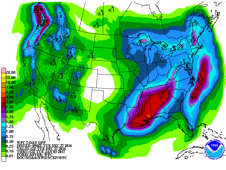 More Soon, Jeff Derry CSAS Storm #6: Xmas Bonus
Greetings from Silverton,
Storm number six was a holiday surprise! Originally forecast to swing far south into Mexico, this little low-pressure system tracked back north out of the Gulf of California and plowed right through Colorado instead. This storm came almost due out of the south, and the San Juan Mountains were favored statewide. The southern San Juans stole the show with storm snow totals at Wolf Creek double those of Red Mountain Pass. All told the Senator Beck Basin picked up 8 inches of relatively dense snow, at least by Colorado standards, with 0.8 inches in snow water equivalent. The atmosphere is wasting no time delivering another round of gifts to the state. A major storm system is moving in over the weekend. There is a HUGE amount of moisture associated with this next system, which means snow totals could easily exceed the forecast. Either way, expect strong winds and heavy snowfall through the weekend. Please see attached Storm #6 Report. More from Silverton soon, Jeff Derry CSAS Storm #5: A Big One
Greetings from Silverton,
Our fifth winter storm of the season laid a thick blanket of snow across the San Juan Mountains.This productive system brought extreme winter weather conditions to the entire state, delivering brutal cold, severe winds and significant precipitation. Winter storm #5 arrived earlier and stayed longer than originally forecast.Over the storms 62 hours the Senator Beck Basin saw temperatures plunge well below 0F, winds gust over 90 mph and a near doubling of snow depth in some locations. Precipitation totaled 2.3″. An unexciting jet stream will deliver stable weather to the San Juans this week. Our next chance for precipitation looks like flurries to kick off the weekend and a stronger system moving into the region early next week. For now, enjoy the sun! The full Storm #5 report is attached. More from Silverton soon, Jeff Derry CSAS: Storm #4
Greetings from Silverton,
On Sunday we saw a 10-hour storm bringing 22 mm (0.9″) precipitation accompanied by up to 70 mph wind gusts. The last few weeks have experienced active weather patterns. Storms across eastern Utah and western Colorado will be back on the radar late Tuesday and Wednesday, and then again over the weekend that should bring more mountain snowfall. Please see the Storm #4 report attached. More Soon, Jeff Derry Center for Snow: Storm #3
Greetings from Silverton,
Yesterday we saw the remnants of the last leg of a four day storm tapper off. The storm comprised of a few different systems stacked pretty close together. On Saturday the storm(s) were ushered in for 7 hours with strong winds out of the south, with gusts averaging around 49 mph (22 m/s) while 0.67″ (17 mm)precipitation fell. Then the wind shifted out of the SW-W for the next 12 hours with gusts still remaining around 43 mph (19 m/s) but with precipitation tapering off to 0.2″ (5 mm) for the period. From there, winds stayed out of the WNW-N for the remaining 56 hours with gusts gradually lessening to around 25 mph (11 m/s). Precipitation remained pretty consistent throughout, the longest period without precipitation was 5 hours on Monday morning. These storm events helped seriously kick start formation of the snowpack after a long dry spell (besides the ~2″ of precipitation from the Nov. 17 and Nov. 20-22 storms) going back to September. Senator Beck Study Basin received a total of 2″ (52 mm) precipitation from Storm #3 with some areas of the San Juans receiving 3″. Pretty much the entire western half of Colorado is considered abnormally dry and most of the eastern half of Colorado is considered in moderate drought conditions by the Colorado Climate Center. Below, based on SNOTEL data, is the snow water equivalent percent of median conditions for the major Colorado river basins, as of November 30, 2016. 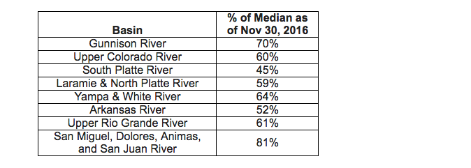 The current outlook (below) indicates Colorado receiving less than 1″ new precipitation next week. Thursday/Friday the central and southern mountains may see 3-6″ of snow. The NWS reports a strong trough bringing precipitation to eastern Utah and Western Colorado by early Monday morning through daybreak Tuesday. The models are in disagreement as to where the system moves from there, but they do agree that cold air will be plentiful starting Tuesday. Please see the attached storm report. More Soon, Jeff Derry CSAS Storm 1 & 2: A Taste of Winter
Greetings from Silverton,
Well we finally received enough snow here at Senator Beck Study Basin, near the summit of Red Mountain Pass, to say that winter is underway. The Center for Snow defines the start of the snow season in Senator Beck as at least 50% of the Basin being covered with persistent snow. Monday, November 21 defines this day, arriving a little late but most welcome. Starting Thursday, November 17, we received two storms, the second storm ending Tuesday, November 22. I am issuing Storm Report #1 a tad late, we had a number of days where our very fragile phone line that transmits data from our meteorological stations to the office was waiting to be repaired. You got to appreciate a phone service technician who carries snow shoes in his truck and is not afraid to use them. The first storm, coming in from the north/northwest and lasting the day of Thursday, Nov. 17, brought 15 mm (0.6″) precipitation. The second, lasting Sunday, Nov. 20 – Tuesday, Nov. 22, came in from the southwest and delivered 33 cm (1.3″) of precipitation. No dust was observed being deposited from this event. Please see the attached Storm 1 and Storm 2 reports. We are in an “active” period for potential precipitation events. A quick moving storm is expected to come through later today and tomorrow. The next system is expected to arrive over the weekend. Have a Great Thanksgiving! More soon, Jeff Derry
2015-2016 WINTER STORM REPORTS:
CSAS Storm #24
Greetings from Silverton,
The stormy weather over the last few days has brought Storm #24 here at out Swamp Angel Study Plot (SASP). Precipitation mostly fell as rain at SASP (11,060′) while at the Senator Beck Study Plot (12,180′) it appears to have been mostly in the form of snow. Today thru Thursday night the chance of precipitation remains 30%-70% with conditions expected to dry out later this week. A complete Storm #24 report is attached. More Soon, Jeff Derry CSAS Storm #22 and #23
Greetings from Silverton,
The active weather systems over the last few weeks have helped southern Colorado make up for the February to mid-March dry period. Over the last few days it has been cloudy with frequent rain and snow here in Silverton and at our Senator Beck Study Basin. Since Friday we have received a total 2″ of precipitation. Since April 23, we have received 4.2″ of precipitation. The precipitation has been falling as moist snow at higher elevations and rain/snow everywhere else. Storm #22 occurred Sunday, May 8 thru the afternoon on Monday, May 9. That storm event was out of the southwest and totaled 1.1″ of precipitation.Storm #23 occurred Tuesday, May 10, and was out of the W-SW. This event brought 0.8″ of precipitation. The full Storm #22 and Storm #23 Report is attached. Below is the precipitation outlook for the next 7-days. More Soon, Jeff Derry  CSAS Storm #20 and #21 at Senator Beck Basin
Greetings from Silverton,
Since Monday, April 25, Senator Beck has received a steady stream of precipitation, and, as I write this e-mail it is snowing and expected to continue through Monday, dissipating into Tuesday morning. This weeks precipitation has consisted of several back-to-back synoptic scale systems that have not allowed a break greater than 12 hours between events. It is the first time this WY2016 season this has happened. Our storm definition, at least 12mm of precipitation with no break greater than 12 hours, has been tweaked to better reflect, with hopefully a little better accuracy, the number of storm events we have been receiving. The first storm is defined as occurring from 1200 MST Monday, April 25 to 2400 Tuesday, April 26. The second storm is defined between 0700 Wednesday, April 27 to 0200 Friday, April 29. All total, from April 25-30, Senator Beck received 1.9″ of precipitation. The NWS forecasts calls for a high pressure dominating late Tuesday thru Wednesday night. The next strong low will move onshore Thursday and be in the Four Corners Regions Saturday afternoon. The full Storm #20 and Storm #21 reports are attached. More Soon, Jeff Derry CSAS Storm #19: 1.5″ Precip at SASP April 15-17
Greetings from Silverton,
The lingering state-wide Spring storm seemingly left the San Juan region a little earlier than expected, but just as I was about to send out this report for Storm #19, our Swamp Angel Study Plot received 5 mm (0.20″) of precipitation and 10 cm (4″) of addition snow accumulation. The official storm occurred April 15-17. High winds out of the SW ushered in the storm in some areas of the State but as of right now we are reasonably sure a new dust event did not accompany. The official precipitation total is 38 mm (1.5″), if we include all the spits of moisture received outside the storm duration, the precipitation received at SASP is 44 mm (1.7″). SASP accumulated 33.5 cm (14″) of snow and SBSP 29.4 cm (11.6″). A nice dose of precipitation, most definitely needed especially in the Southern Basins. Hopefully we’ll see a few more of these events before winter completely bids us farewell. Storm Report #19 is attached. More Soon, Jeff Derry CSAS Storm Report #18
Greetings from Silverton,
Storm #18 officially came through Senator Beck Basin starting between 1500-1600 on Monday, March 28 thru 400 Wednesday, March 30. The storm was preceded with strong S’ly winds and high winds continued while the snow fell. The first 28 hours of the storm the average hourly gust was 63 mph, creating real blizzard like conditions at times in Silverton and surrounding areas. We received 9.7″ (24.7 cm) of new snow accumulation and a solid 1.0″ (25 mm) of precipitation. On Wednesday, March 30, around 7:00am the winds shifted out of the North. We continued to see another 0.24″ (6 mm) of precipitation until late Thursday night, but there was a gap of precipitation greater than 12 hours thus ending the official duration of the storm. The week to come looks pretty tame with only a 20% chance of precipitation in the Silverton area, snow showers, in the 2-5″ range look to favor the north and central mountains. The full Storm #18 Report is attached. More Soon, Jeff Derry CSAS Storm Report #17
Greetings from Silverton,
Friday night through most of Saturday we received 6″ of new snow accumulation and 0.7″ (19 mm) of precipitation. Not much but we’ll take it. Winds were out of the WNW-NNE. A full report for Storm #17 is attached. Looking ahead……A cold front preceded by gusty winds is expected to come into western Colorado Monday and Tuesday. The system is creating wind and dust advisories for many areas including SW Colorado and possibly Grand Valley. The forecast calls for areas of blowing dust starting Monday going into Monday night. Snow is expected to start Monday night and go into Wednesday. 4 to 12 inches are possible for the mountains of western Colorado. More Soon I Hope, Jeff Derry CSAS Storm #16: March 22-23
Greetings from Silverton,
A couple days ago we hit Storm #16 here at Senator Beck Basin. On Tuesday, March 22, the storm started out of the SW bringing light dust to Senator Beck and heavier amounts of dust to the eastern San Juan Mountains. The wind then shifted out of the WNW to N and it began snowing until 1900 on Wednesday, bringing 12.6″ (32.1 cm) of new snow to our now 5.2′ (1.57 m) snowpack at SASP. Please see a full report attached. More soon, Jeff Derry CSAS Storm Report #15: March 6-8
Greetings from Silverton,
Our first storm of March WY2016 moved east of our Study Basin early this morning. This was a wet two day storm with average 17 mph winds (peak gusts up to 72 mph) out of the SSW. The NWS indicates a closed low over Mexico will move through today/tonight with a forecast of scattered precipitation and isolated heavy bursts of snow above 9,000′. The next 7-10 days is expected to bring an unsettled pattern with a closed low just south of the Four Corners Saturday/Sunday bringing some precipitation to our area and next week (Monday/Tuesday) we are to expect a long wave trough bringing widespread showers, it is still unclear as to the intensity and extent of these systems. Storm #15 Report is attached. More Soon, Jeff Derry CSAS Storm Report #14
Greetings from Silverton,
Quick moving Storm #14 came through the Senator Beck Study Area starting Monday morning and passed Tuesday afternoon. The Storm brought 21.1 cm (8.3″) of new snow accumulation, enough to cover D2, the second dust-on-snow event for WY2016, for the time being. Winds were pretty calm and out of the NNE for the duration. A persistent ridge has settled over the area bringing a dry warming trend. The next chance for precipitation is not until Monday/Tuesday. Storm #14 Report is attached. More Soon, Jeff Derry CSAS Storm #13 at Senator Beck Basin
Greetings from Silverton,
Productive Storm #13, lasting 82 hours, ended yesterday afternoon. We received 55 mm (2.2″) of water content at SASP. Wind direction was out of the S-SW for the bulk of the storm, with speeds consistently 22-45 mph, and shifted out of the north on the last day. With the passing storm we now have frigid temperatures in the minus 20’s (Celsius) at night and in the minus high teens during the day. The complete Storm #13 Report is attached. More Soon, Jeff Derry CSAS Storm #12 at Senator Beck Basin
Greetings from Silverton,
Yesterday evening Storm #12 came to an end. This was a 34 hour storm that brought 24 mm (0.9″) of water content to SASP. Average wind speeds of 7 m/s (15.7 mph) were out of the NW to NNE for the duration of the storm. For the month of January alone, we have received 76 mm (3″) of precipitation. Our YTD total is now up to 518 mm (20.4″) of cumulative precipitation at SASP. A complete Storm #12 is attached. More soon, Jeff Derry CSAS Storm #11: 1-Day Wallop
Greetings from Silverton,
Yesterday, Wednesday January 20, we experienced a quick moving storm system passing through the San Juan Mountains. In 22 hours it brought 17 mm (0.7″) of water equivalent and 17 cm (6.7″) of new snow to Swamp Angel Study Plot near the summit of Red Mountain Pass. Storm #11 Report is attached. Today is a blue bird day with the wind wisping the snow over and around the peaks. More Soon, Jeff Derry CSAS Storm Report #10
Greetings from Silverton,
On Sunday at 3:00pm, Storm #10, lasting 59 hours, ended bringing 35 mm (1.4″) of water content to Swamp Angel Study Plot. I was expecting to compile the Storm Report on Sunday, but the precipitation kept coming until late Sunday afternoon. The storm systems that passed through brought 12 mm of precipitation on Friday, 10 mm on Saturday, and 13 mm on Sunday. Starting on Saturday at 3:00pm thru Sunday at 9:00am, average wind speeds kicked up to 13 m/s (29 mph), with average peak gusts of 19 m/s (43 mph), and max peak gust of 27 m/s (61 mph), redistributing the freshly fallen snow most noticeably in terrain above treeline. A complete Strom #10 Report is attached. Jeff Derry Winter Storm #8 and Storm #9: December 19-25, 2015
Greetings,
As we all know, the Colorado mountains, including Senator Beck Basin and Red Mountain Pass, received a very nice bump in snow accumulation over the last 7 days. By definition (at least 12 mm of precipitation with no more than 12 hours without recorded precipitation), we saw two storms pass through since December 19. The first storm event occurred December 19 through December 23. After approximately 15 hours, Storm #9 moved in December 24-25. Precipitation totaled over 4″ of water equivalent for both storms with 30″ of new snow at SASP – This was a major event. Winds were strong (particularly for Storm #9) out of the S thru W-NW with gusts greater than 60 mph. Even with a fair amount of wind erosion, 20″ of snow accumulated at SBSP (12,180′). This Tuesday morning another system is expected to pass the four corners region, bringing an increasing chance for snow, although significant accumulation is not expected with this system. A complete report for Storm #8 and Storm #9 is attached. Happy Holidays, Jeff Derry CSAS Storm #7 Report: December 14-16
Greetings,
34 hours after Storm #6 (December 11-12) ended, storm #7 rolled into town for 41 hours and delivered 25 mm (1 in) of precipitation, officially ending Wednesday at 1:00 am. Total precipitation received over the last 7 days is 50 mm (2 in), and we now have 1 meter of snow at SASP. A complete Storm #7 report is attached. Take Care, Jeff Derry CSAS Storm #6 Report
Greetings from Silverton,
Storm #6 began late Friday, December 11 and ended Saturday, December 12. Lasting only 24 hours and delivering 17 mm (0.7 in) of precipitation. We are likely going to see another storm this week, the forecast calls for 6-12″ of new snow accumulation. A complete Storm #6 report is attached. More Soon, Jeff Derry Winter Storm #5: November 15-17, 2015
Greetings from Silverton,
It’s a calm (29 F) and partly sunny day here in Silverton. Storm Report #5 is attached for winter 2015/2016 thus far. This Storm started with some intensity for the first 8 hours and then tapered to mostly 1-3 mm/hr of precipitation for the remaining 24 hours. This was a significant precipitation event with a total gain of 54 mm (2 inches) of water content at SASP. Snow depth at SASP increased 53 cm (21 inches), and 31 cm (12 inches) at SBSP. This storm had periods of high peak gusts and periods of high sustained winds. See the variable SBSP snow plot (above treeline) compared to the SASP (below treeline) in the attached pdf. For three hours early Monday (Nov 16) morning gusts ranged from 23-41 m/s (52-91 mph) from the S-SW. Then, for 17 hours beginning at 2100 on Monday, peak gusts were sustained between 14-22 m/s (32-50 mph), with average gusts for this time period of 19 m/s (42 mph), from the N. Our Water Year total precipitation is 236 mm (9 inches). We are above the 11 year average of 191 mm (7.5 inches) collected by the end of November. More Soon I Hope, Jeff Derry CSAS Storm #4
Greetings from Silverton,
Storm #4 came between 1500-1600 hrs MST Tuesday, November 10 and left 1600 hrs MST Wednesday, November 11. SASP snow depth increased 24.4 cm (9.6 inches), current total snow depth is 45 cm (17.7 inches). SBSP was wind affected gaining only 1.3 cm (0.5 inches) of snow. The storm brought approximately 18 mm (0.7 inches) of precipitation. A pesky spruce needle got stuck in the check-valve of the precipitation gauge, so precipitation totals were reconstructed using nearby SNOTEL data. A complete Storm #4 report is attached. Take Care, Jeff Derry Building the Snowpack – Storm #3
Greetings from Silverton –
Last week we saw Storm #3 which started late evening Tuesday and ended early eveningThursday. A power failure resulted in a data glitch, delaying the creation of this report. Storm #3 totaled 36 mm (1.4″) of water content, our water year total precipitation is now 163 mm. Rather high winds accompanied this storm with average speeds of 20 mph with gusts up to 67 mph. Swamp Angel (elevation 11,060′) saw the snowpack increase 34 cm (13.5″). Senator Beck (elevation 12,180′) saw an increase of 24 cm (9.4″). The forecast is for a fast moving storm to move in late this afternoon. Snowfall is expected to increase and peak overnight/tomorrow morning, and exit the area by Wednesday. Anticipated snowfall will be half a foot to over a foot. You will likely be seeing another CSAS storm report soon. Attached is a PDF with Storm #3 details. More soon, Jeff Derry Snowcover begins in Senator Beck Basin Greetings from Silverton – Over the past week the western San Juan Mountains have begun developing the Winter 2015/2016 snowpack. Two back-to-back storms, recorded as CSAS Winter Storms #1 and #2, have produced enough snowcover to persist over at least 50% of Senator Beck Basin henceforth, even if we have a subsequent dry and sunny period. Storm #1, October 18-20, fell as mixed precipitation at Swamp Angel Study Plot (11,060′), without any accumulation of snow, but did fall as primarily snow at the higher Senator Beck Study Plot (12,180′). Storm #2, October 22-23, fell as snow at both study plots. Neither Storm was particularly intense, with only moderate winds and precipitation intensity. CSAS looks forward to receiving a more normal quota of Winter Storms here in the San Juan Mountains this season, at somewhere around 25 total storms, as opposed to the poor total of only 18 Winter Storms last season. We will soon (in early November) be adding a new chart of “Cumulative Winter Storm Count” data to our graphed precipitation webpage
