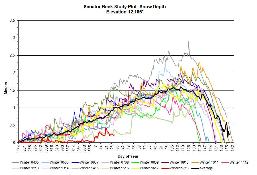
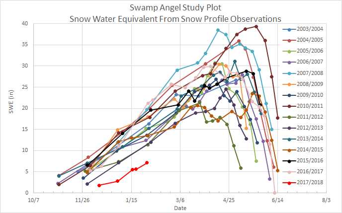
Winter Storm Data Archive
MOUNTAIN SYSTEM MONITORING: WINTER STORM DATA
This Precip and Storm Report Excel Workbook contains the current and past 13 seasons of CSAS winter storm data, including:
- Dates, times and duration of each winter storm event (2003-current)
- Change in the height of snow at both our alpine Senator Beck study plot and our subalpine Swamp Angel site.
- Peak gust data from our Putney site.
- Mean and maximum precipitation intensity during each storm
- Total new water accumulation in mm for each storm event.
- Summary data for each month of the season.
- Cumulative annual precipitation graph by month
| Past Winter Storm Reports: |
See our Current Conditions for the latest hourly data. All times shown are in Mountain Standard Time (MST)
- CSAS Storm Definition >= 12 mm SWE with no break in precipitation >12 hours
- SASP =Swamp Angel Study Plot(11,060′, in sub-alpine meadow)
- SBSP =Senator Beck Study Plot(12,186′, on alpine bench)
- PTSP =Putney Study Plot(12,323′ alpine ridge ‘free air’ site)
Greetings from Silverton,
Our 15th winter storm of the season brought us more snow than we expected. A concentrated parcel of humid air and favorable Southwest flow brought 10.9 inches (27.8 cm) of snow to Swamp Angel Study Plot. Moderate winds during the storm also allowed the Senator Beck Study Plot to pick up some new snow, with 9.5 inches (24.1 cm) of snow height gain at that higher elevation station.
Before this storm multiple merged dust layers were present on the snow surface. Events D3-7 had emerged on nearly all slopes in the range, with the exception of high elevation shaded aspects and isolated wind drifted areas. This layer is dark and was significantly speeding up snowmelt, with notable snowpack losses observed at Swamp Angel. This recent storm buried these layers under fresh, white snow, resetting our albedo and slowing melt in the San Juans.
For now, it appears that this will be the last notable storm until the middle of the month, possibly longer. Warm spring weather and sunny skies are in the forecast for the next 10-14 days. If the pattern shifts we’ll let you know.
See the complete storm report attached.
More from Silverton soon
Greetings from Silverton.
The San Juan Mountains enjoyed a nice blast of moisture starting at the end of this past week and continuing into the weekend. During our 14th winter storm event of the season the Swamp Angel Study Plot picked up 1.3 inches (32mm) of SWE as 6.2 inches (15.8 cm) of dense snow. The snow settled significantly during the storm and is now becoming wet and is only about 4 inches thick. The Senator Beck Study Plot also got a nice bump in snowpack, with 5.4 inches (13.7 cm) of gain in snow height. Relatively calm winds during the bulk of the storm kept this snow in place at higher elevations, instead of the serious redistribution we’ve been seeing consistently this year.
This storm was immediately preceded by our 7th dust event of the season. D7 started as a dry event but became wet as dust been mixed with precipitation as the snows (and at lower elevations rain) rolled in. CSAS will be at the Swamp Angel Study Plot to sample this event today. While this storm is acting to keep D6/7, which are merged, off of the surface, this effect may not last too long. With low chances of precipitation and warm temperatures forecast for the coming week we expect to see this new snow melt in part or completely in the near future, especially on more solar aspects where in some cases the majority of the seasons’ dust layers are merged.
If the weak system moving into the region tonight gains strength it could further bury these dust layers and add to our snowpack, but given the current models we are not too hopeful. The system simply doesn’t contain enough moisture to expect significant snowfall, although other parts of the state could see slightly higher snow totals, especially in the northern mountains where the storm will impact more directly.
Find the full storm report attached below.
More from Silverton soon.
CSAS Winter Storm #13: April 12-14

CSAS Winter Storm #11: March 22-23
Greetings from Silverton,
At the end of this past week the Senator Beck Basin received its most underwhelming winter storm so far this season. Over the course of 23 hours, Swamp Angel Study Plot (SASP) picked up 0.5 inches (13mm) of water and saw snow gains of 2.7 inches (6.9 cm), as well as a little bit of rain at the onset of the storm. Senator Beck Study Plot was stripped of all available snow by high winds and lost a little snow throughout the storm, coming out 0.8 inches (2.1 cm) short on snow height when the storm rolled out on Friday afternoon. This makes sense considering this storm produced gusts to 83 mph at the Putney Study Plot
The rain at SASP is the big news of this storm. While the 3mm of precipitation that we suspect came in as rain will not have any notable influence on melt, the first rain on snow event of the season at higher elevations (SASP is at 11,060 ft.) does signify that the melt season is approaching. Today a CSAS team found snowpack approaching isothermal at SASP and observed dust at or near the snow surface at solar aspects at and below 11,000 ft. Most southerly facing slopes below 10,000 ft. are nearly or completely snow free around Red Mountain Pass.
As the dust approaches the snow surface, keep an eye out for weekly CODOS updates tracking the impacts of the dust already in our snowpack and any additional events to come. With high winds in the San Juans as we write this report and a dry dust source region we are on the lookout for any dust loading.
Please see Storm Report attached.
CSAS Winter Storm #10: March 18-19
Greetings from Silverton.
Winter Storm #10 in the Senator Beck Basin came in hot on the heels of Storm #9 and delivered more snow to the San Juan Mountains than its predecessor. Over 28 hours the Swamp Angel Study Plot received 0.8 inches (20mm) of water as 10.9 inches (27.8cm) of light, dry snow. In a continuing trend, the Senator Beck Study Plot fell victim to wind transport and was unable to make major gains in snow heights, picking up only 1.4 inches (3.6 cm) of snow.
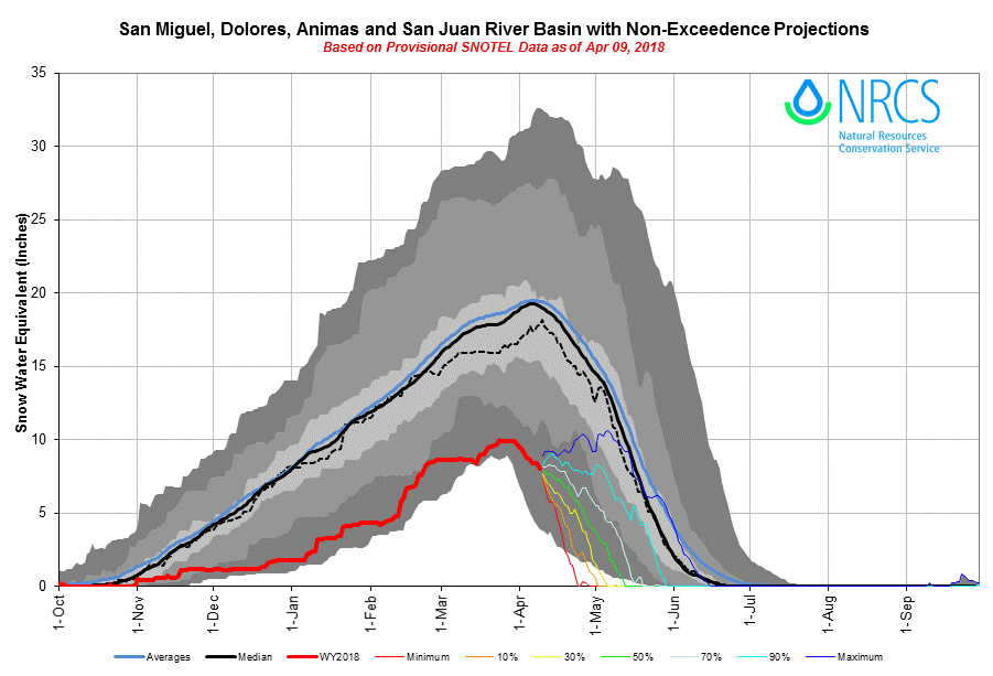
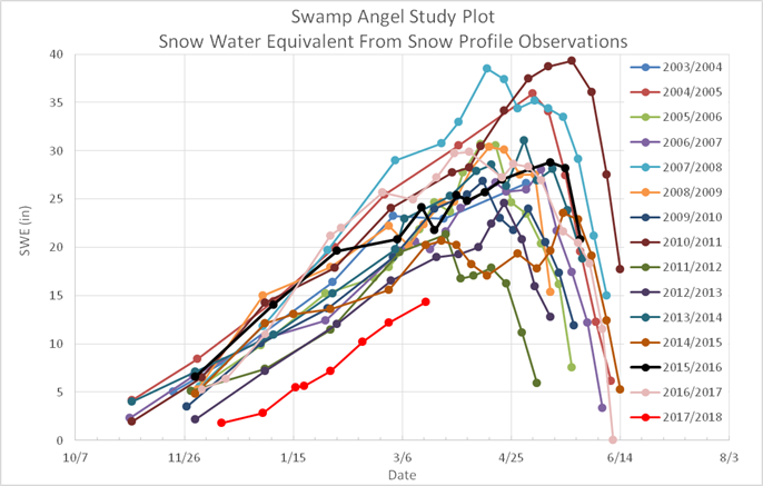
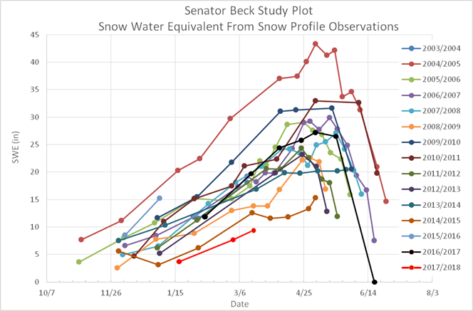
While the new snow is a very welcome addition to our anemic snowpack we are still far behind in winter storms, having received less than half of the average number of notable storms for the date. At our study sites, we continue to see the lowest snow season on our CSAS period of record (See SWE figures below). With the spring equinox upon us and the long-term outlook showing more of the same, any snow we can pick up in the San Juan Mountains will be welcome down the road when we enter the melt season. As of now there is no chance for major precipitation in the next week, with some flurries expected around Friday.
Fortunately, we did not receive any dust during this storm, although we had expected it after looking at weather cameras in dust source regions. Partway through the storm the winds shifted to the north and any blowing dust was steered south of the range before the chance for deposition. Our snowpack remains in the “low” dust bracket of our Dust Enhanced Runoff Classification model (more info here: http://www.codos.org/#dust-enhanced-runoff-classification), which is a good way to start spring. However, there is plenty of time to receive more dust and the deserts are dry this year, so keep an eye on our CODOS page for any dust updates.
More from Silverton soon.
CSAS Winter Storm #9: March 15-16
Greetings from Silverton,
CSAS returned from our first CODOS tour of the season and was greeted with Winter Storm #9 in the Senator Beck Basin for the 2018 water year. Since we are well behind on storms for this season (average for this date is more than 20) and haven’t seen notable snowfall since the end of February, this snow was greatly appreciated here in the San Juan Mountains.
Our ninth winter storm was nothing spectacular, but the Swamp Angel Study Plot picked up 7.9 inches (20.1cm) of much needed snow, which totaled 0.6 inches (16mm) in snow water equivalent. Up high the wind once again did a number on the new snow, redistributing and in some places completely removing the new flakes. The higher elevation Senator Beck Study Plot only saw snow height gains of 1.7 inches (4.3cm).
CSAS was out in the Basin today and found significant drifting and blowing snow up high, while sheltered areas had dry, low-density new snow on shaded aspects. Overall, snow conditions are highly variable in the Northern San Juans, ranging from deep drifts to bare ground to crusts and ice.
Over the next couple days CSAS will be working on a report from our recent CODOS Tour, where we assessed the status of dust layers in the snowpack and snow water equivalent on a statewide scale. This was our first of several statewide tours that we will carry out this season. Look for that report on the website in the coming days.
See the full report for Winter Storm #9 attached.
CSAS Winter Storm #8: Feb 21-25
Greetings from Silverton,
Winter storm #8 in the Senator Beck Basin was a slow burner. Over 90 hours the Swamp Angel Study Plot saw 1.1 inches (29mm) of snow water equivalent as 4.9 inches (12.5cm) of snow. Up in the alpine, the Senator Beck Study plot only picked up 2.2 inches (5.6 cm) of snow over this nearly 4-day period, likely loosing snow to wind and transport.
These are low snow totals considering the amount of moisture, and these are due to the long duration of the event. The new snow had ample time to settle over the course of the storm, so the snow totals reported here take that settlement into account. Additionally, snow from winter storm #7 hadn’t yet had a chance to fully settle before storm #8 rolled in, adding to settlement in the snowpack. However, even though the storm was slow, came in low intensity waves and delivered little in terms of snow totals, the 29mm of SWE was a welcome addition to this season’s anemic snowpack.
Unsettled weather returns to the region around Wednesday, although precipitation totals are not looking like they’ll deliver another winter storm (by CSAS criteria). However, if the current pattern shifts to the southwest we could see more significant snow. We’re keeping our fingers crossed.
See the complete winter storm #8 report attached.
CSAS Winter Storm #7: Feb 18-19
Greetings from Silverton,
The Senator Beck Basin in the San Juan Mountains saw it’s seventh winter storm of the season. The event was no drought-buster, but the mountains still saw some much needed snow. The event was characterized by strong southwest winds and mostly light snowfall, punctuated by short periods of higher intensity precipitation.
All told, Swamp Angel Study Plot picked up 6.3 inches (16.1cm) of snow as 0.6 inches (15mm) of water. To highlight the effects of the strong winds (peak gust of 83.3 mph at Putney), the alpine Senator Beck Study Plot only saw snow height gains of 1.6 inches (4.1cm), suggesting significant wind transport of new snow at upper elevations. Large plumes of windblown snow were observed on nearly all ridgelines in the region during the storm.
The high winds before and during this storm also brought a notable dust event. This is our second dust event of the season and the first observable event with future hydrologic consequences (D1 is located at the base of the snowpack and is barely visible). This event appears to be a significant and widespread deposition of dust across the range. CSAS will visit Swamp Angel tomorrow to sample the dust and assess the characteristics and severity of this event. Look for our report on D2 tomorrow.
Winter Storm Report #7 attached.
CSAS Winter Storm #6: February 12-13, 2018
Greetings from Silverton,
Another nice round of precipitation started just after midnight yesterday through about sunrise this morning. This system brought 1.1″ of water content and just over 1′ of new snow accumulation at Swamp Angel. Persistent strong winds right out of the S-SW accompanied this event with higher elevation wind gusts consistently in the 40-60 mph range.
It is nice to see some sort of a bump in the Southern Colorado SWE plots. Another shot at precip will come through beginning in the mountains on Wednesday evening increasing into Thursday, right now the amounts look to be in the 5-12″ range, higher elevations on the upper end of estimates. Dry conditions return Friday/Saturday.
Please see attached Storm Report.
CSAS Winter Storm #5: February 10-11, 2018
Greetings from Silverton,
Starting yesterday afternoon and going into early morning we received Storm # 5 at Senator Beck. The precip event was preceded by 40-50 mph wind gusts out of the southwest, then turned out of the north when the snow started falling. We measured 0.6″ of precip with 8.7″ snow accumulation at Swamp Angel. Please see attached Storm Report.
We are thankfully in an active weather pattern. The next Pacific storm is moving into the region tonight and sticking around through Monday. Expect stiff winds out of the southwest. Some portions of the desert southwest have received at least a trace of precipitation and the forecast is a bit more on Monday as the trough moves into the Great Basin. This is important as the southwest is in severe drought and we are entering dust season. We need precipitation to stabilize soils as high winds sweep through the dust source region. By the latter half of the week the next trough of low pressure is expected to enter the Western US. Expect another storm report soon, then hopefully another.
CSAS Winter Storm #4: February 5-6, 2018
Greetings from Silverton,
It was a nice surprise to see the snow totals from the Monday/Tuesday storm. We received 0.8″ of water in 11.3″ of new snow accumulation over the 37 hour storm period. We now have 4 Storms on the books for WY2018, average is 13. Please see attached Storm Report
Looking ahead, it is more of the same in the sense that the strong high pressure has shifted slightly east but is still basically in place. The result is northwest flow dominating, bringing weak storms to northern Colorado and Wyoming, and possible light precipitation to central and southern mountains on Saturday. Until then mostly dry. The forecast going out 7 days shows some encouraging possibilities going into next week,
More Soon.
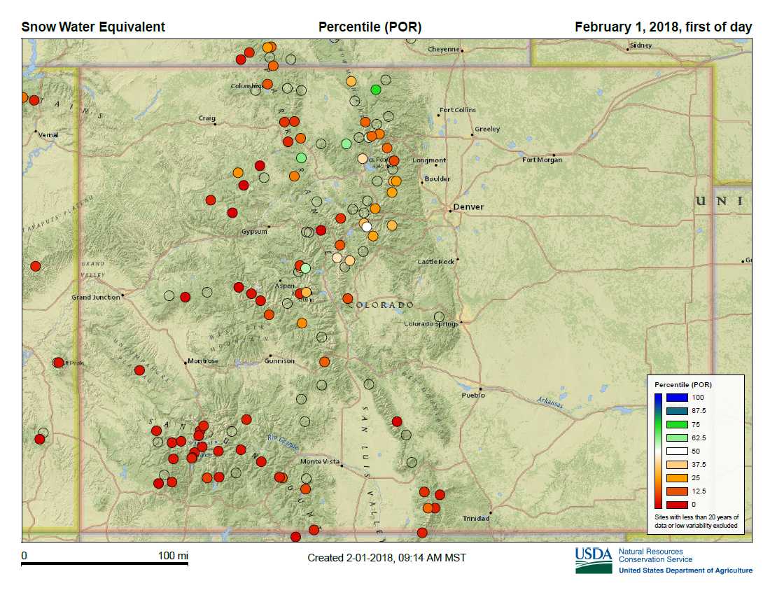
CSAS February 2, 2018: January Recap
Greetings from Silverton,
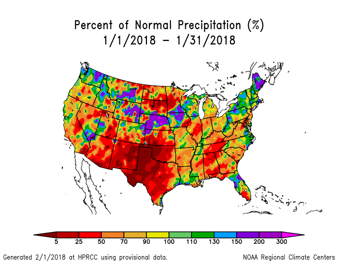
The good news is that we are no longer walking to our 11,060’ Swamp Angel study site like we were the first week of January. From January 8-22 we logged our first three Storms of WY2018. We had 11 days of precipitation in January totaling 3.9” of water, more than October/November/December combined. In the past 9 days we have received 0.16” of precipitation. For the water year we have recorded 7.1” at Swamp Angel and 7.6” at Red Mt. SNOTEL. Red Mt median for this time of year is 10.6”.
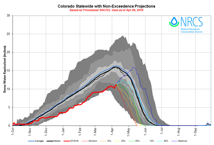
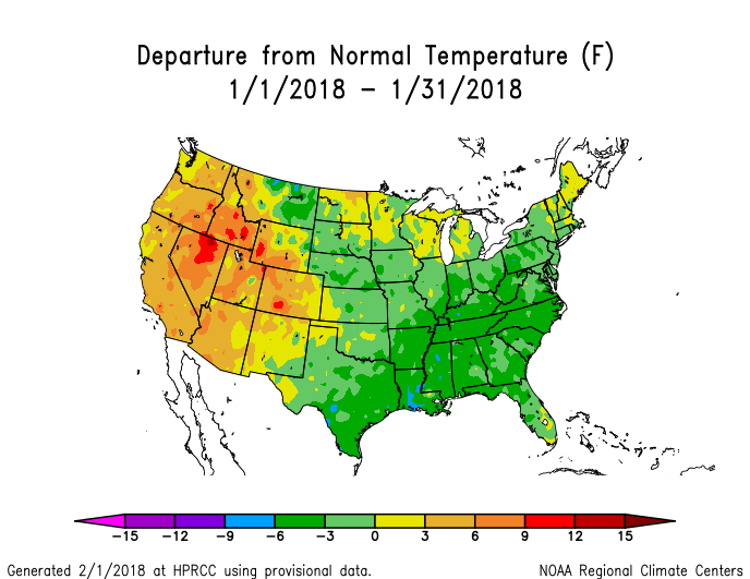
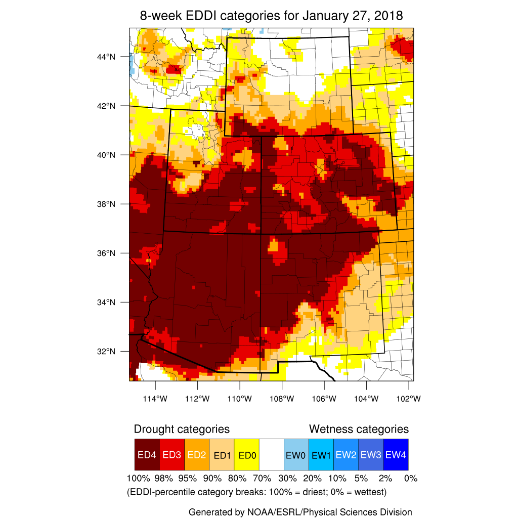
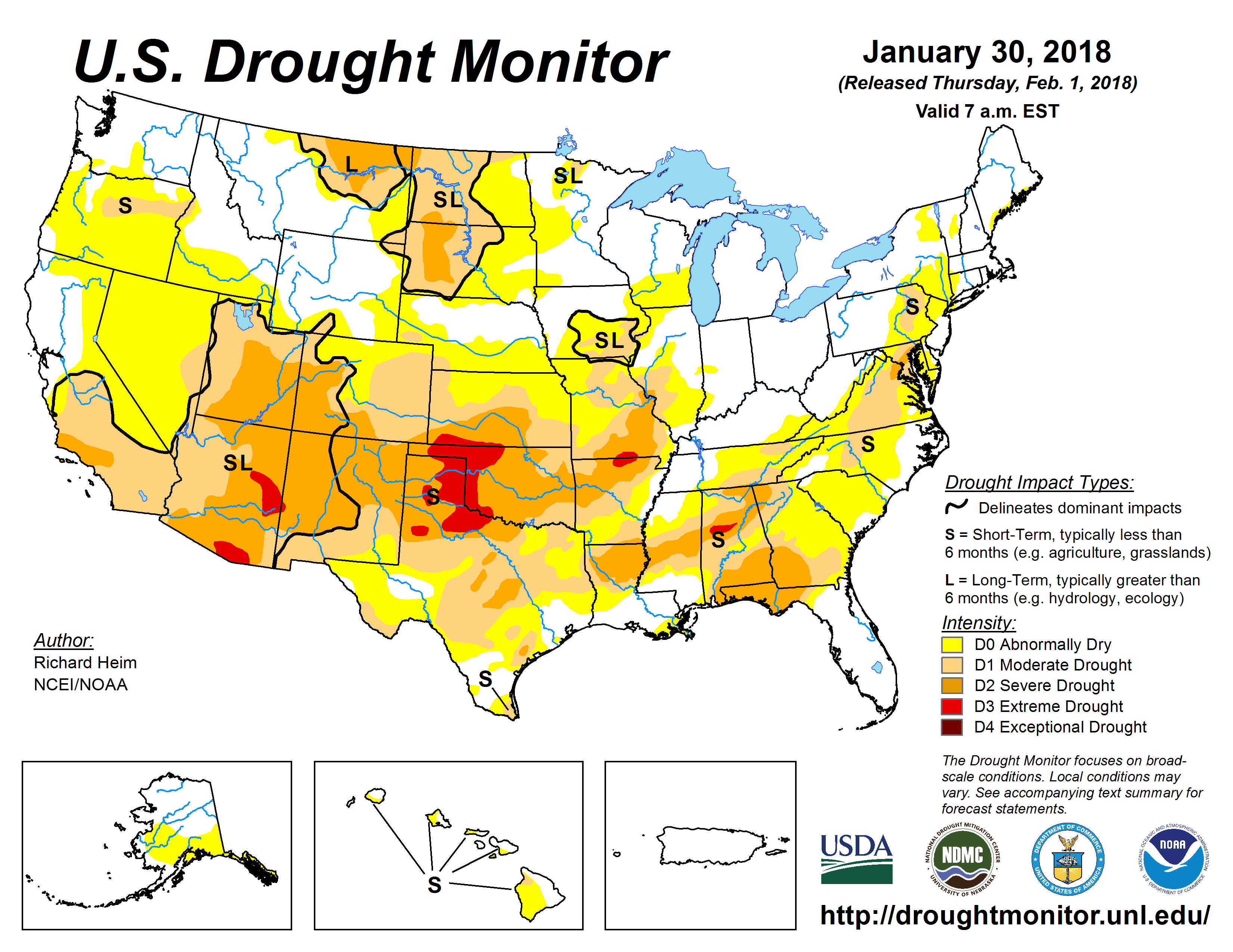
But we still have a long way to go in making up for the dry start to the snow season. To date, for most SNOTEL stations in the San Juan Mountains, this year falls in the driest top 3 on record, with records going back 30-40 years. The central and northern mountains have fared better being 77% of median in the Upper CO Basin, 84% in the South Platte, 80% in the North Platte, and 72% in the Yampa/White Basins. Compared to 36% in southwest basins, 35% in the Rio Grande, and 51% in the Gunnison Basin. To add to lack of snow, the hot temperatures for this time of year are driving up evaporative demand (see image below), particularly at elevations a bit lower than Senator Beck Basin (SBB).
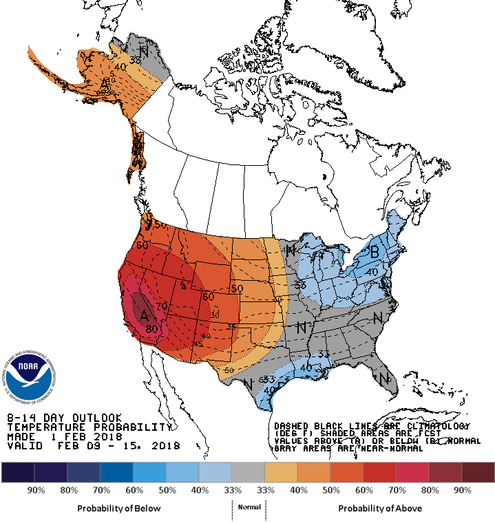
The forecast is not looking very exciting. La Nina conditions are still firmly in place and expected to persist through the winter and weaken in spring, which does not bode well for the southern mountains. The tendency being for La Nina episodes is to push the jet stream north, so that generally favors above-average temperatures and below-median precipitation across the southern tier of the U.S, and below-average temperatures and above median precipitation across the northern tier of the U.S. Colorado, being located in the transition zone of these two extremes can see mixed conditions, but the tendency is for northern Colorado to be favored for more precipitation while southern Colorado for less.
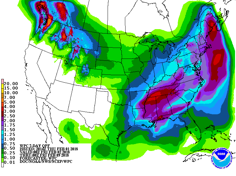
The 14 day outlook is provided below. The high pressure off the west coast will maintain northwesterly flow over western CO. The northern mountains are expected to see light snow periodically over the next 4ish days (totaling 6-12”). For folks in the San Juans it is looking dry in the forecastable future.
Please see pictures and images below.
More Soon.
Photo taken by Andrew Temple on Jan 31, 2018. View from Senator Beck Study Plot (12,200′)
Photo taken by Andrew Temple on Jan 31, 2018. Looking at Senator Beck Study Plot (12,200′).
Swamp Angel Study Plot (11,060′) as of Feb. 1.


CSAS Winter Storm #3: January 20-22, 2018
CSAS Winter Storm #2: January 12, 2108
CSAS Winter Storm #1: January 8, 2018
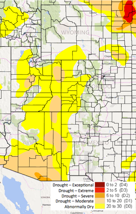
Non-Storm Report #3: December Recap, January 2, 2018 Greetings from Silverton, December 2017 is now behind us and we are still waiting for winter to begin in most of the Colorado high country. Colorado (AZ, NM, and UT) experienced their warmest November on record and one of the driest for many SNOTEL stations around Colorado. December continued the trend of being exceptionally warm – particular in the mountains – and exceptionally dry. Many meteorological stations rank November and December as one of their driest on record. Here at Senator Beck Basin in the San Juan Mountains, October was the 4th warmest and the warmest November and December in our POR. It was the 4th driest October, and driest November and December, by far, in our POR. The folks at Telluride ski resort haven’t seen a drier December in 34 years. Currently, SWE at Swamp Angel (elevation 11,060’) is 2.8” (71 mm), nearby Red Mt. SNOTEL is showing 3.6” (91 mm). Cumulative precipitation since October 1st at SASP is 3.2” (82 mm), and at Red Mt. SNOTEL the same story with 3.3” (84 mm). Average January 1st cumulative precipitation at SASP and Red Mt. is 12.9” (327 mm) and 12” (307 mm), respectively. You might have noticed, but we have yet to issue a Storm Report so far this season since our criteria has not been met – a precipitation event that brings at least 12 mm of precipitation with no gap between measured precipitation greater than 12 hours. Usually by January 1st we have already issued ~9 Storm Reports. So far this season we have not documented a dust event or observed dust-on-snow, where snow exists, in the San Juan Mountains. Assuming we eventually get the snow to melt and unless conditions change across the southwest, the set-up going into the height of dust season (March/April/May) doesn’t look good. The folks at NIDIS and Colorado Climate Center have much of Colorado designated as abnormally dry and much of western Colorado classified as moderate drought. The southern Colorado plateau, our primary dust source, is in moderate drought with a good portion of southern Utah in severe drought. See drought monitor depiction below. Reduced soil moisture as well as stressed and reduced vegetation make soils vulnerable to wind erosion and transport to the Colorado mountains. Last year, for example, the desert southwest was very wet most of the winter season and consequently we documented only 4 dust events with 2 of those events being very light. Looking ahead: The forecast is calling for much of the same for the remainder of this week, mainly dry and mild with temperatures staying several degrees above normal due to an upper level ridge maintaining a dry northwest flow. But…..fingers crossed, there is potential for unsettled weather starting later Saturday into Sunday. Models are digesting a trough pattern over the eastern Pacific with a moderate amount of precipitation potential. The plots below tell the story pretty well. More Soon ![]()
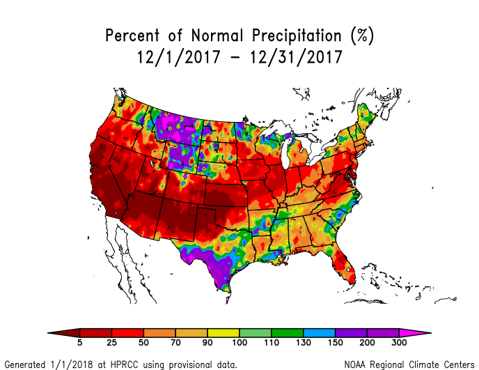
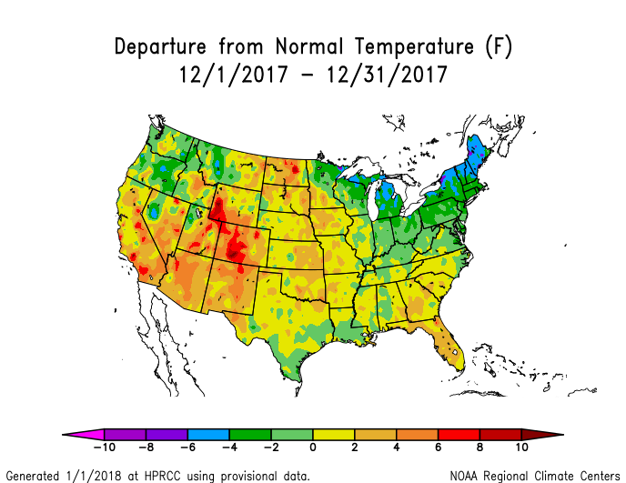
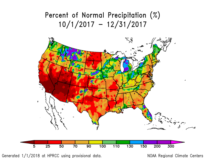
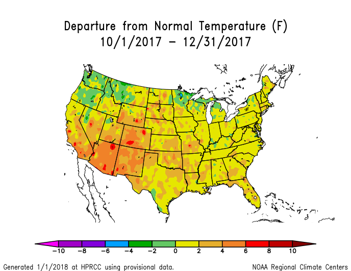
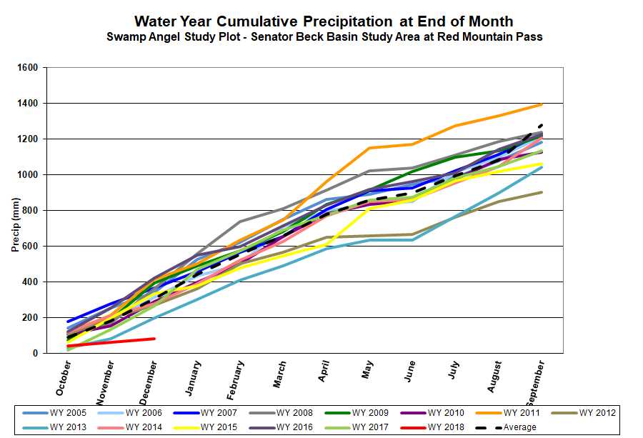
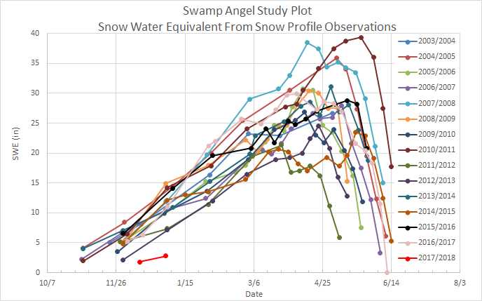
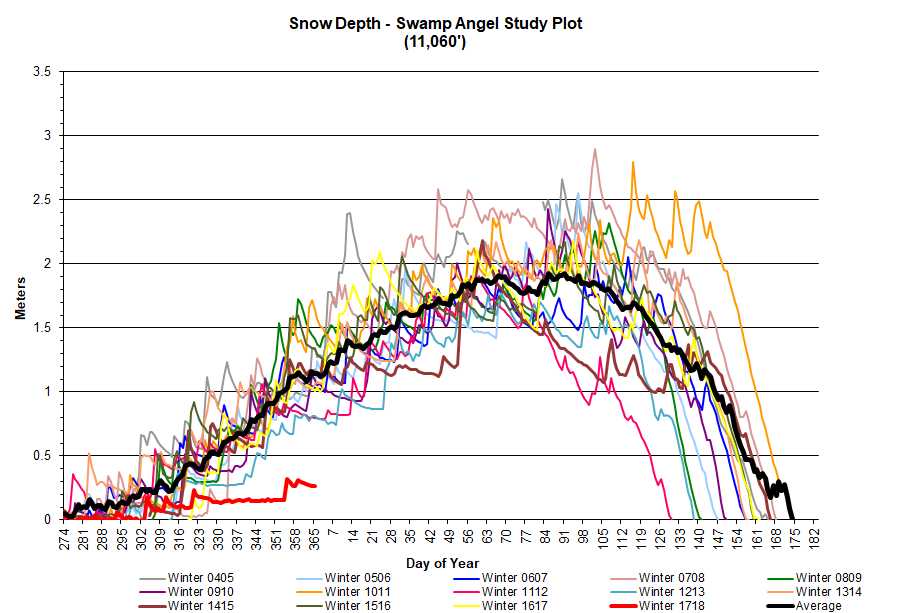
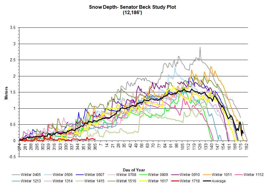
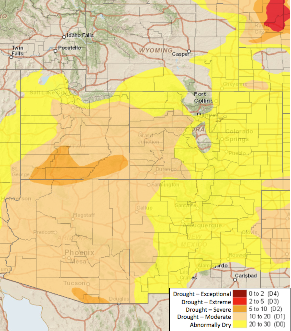
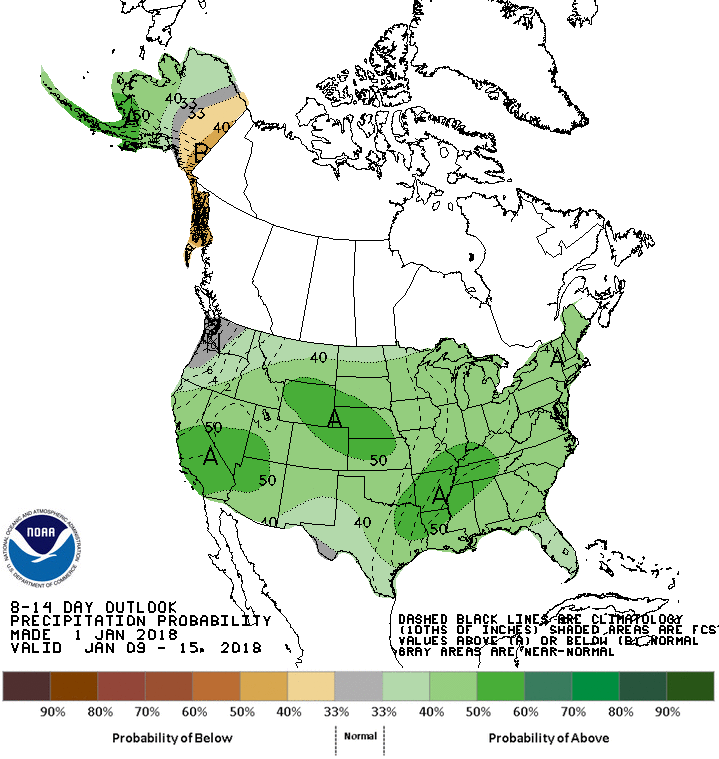
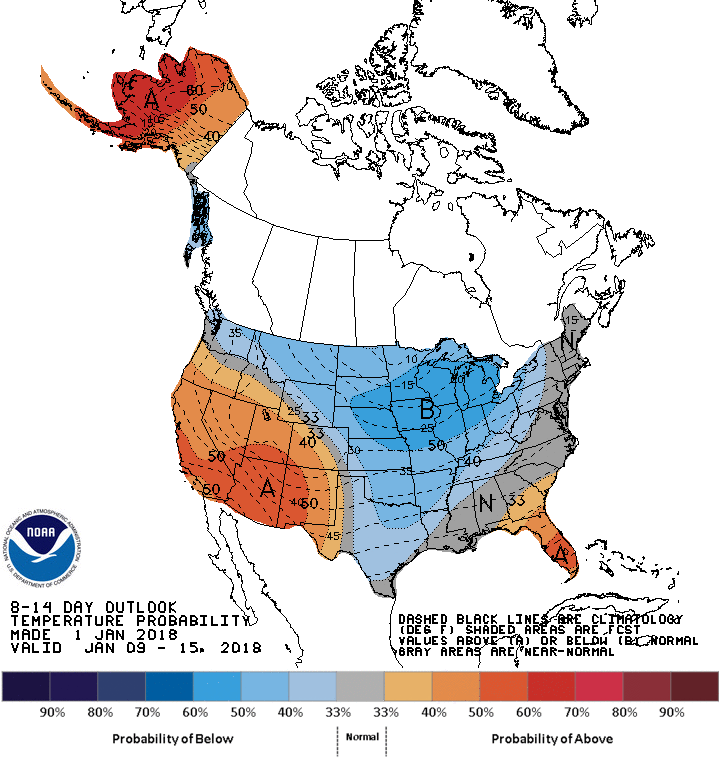
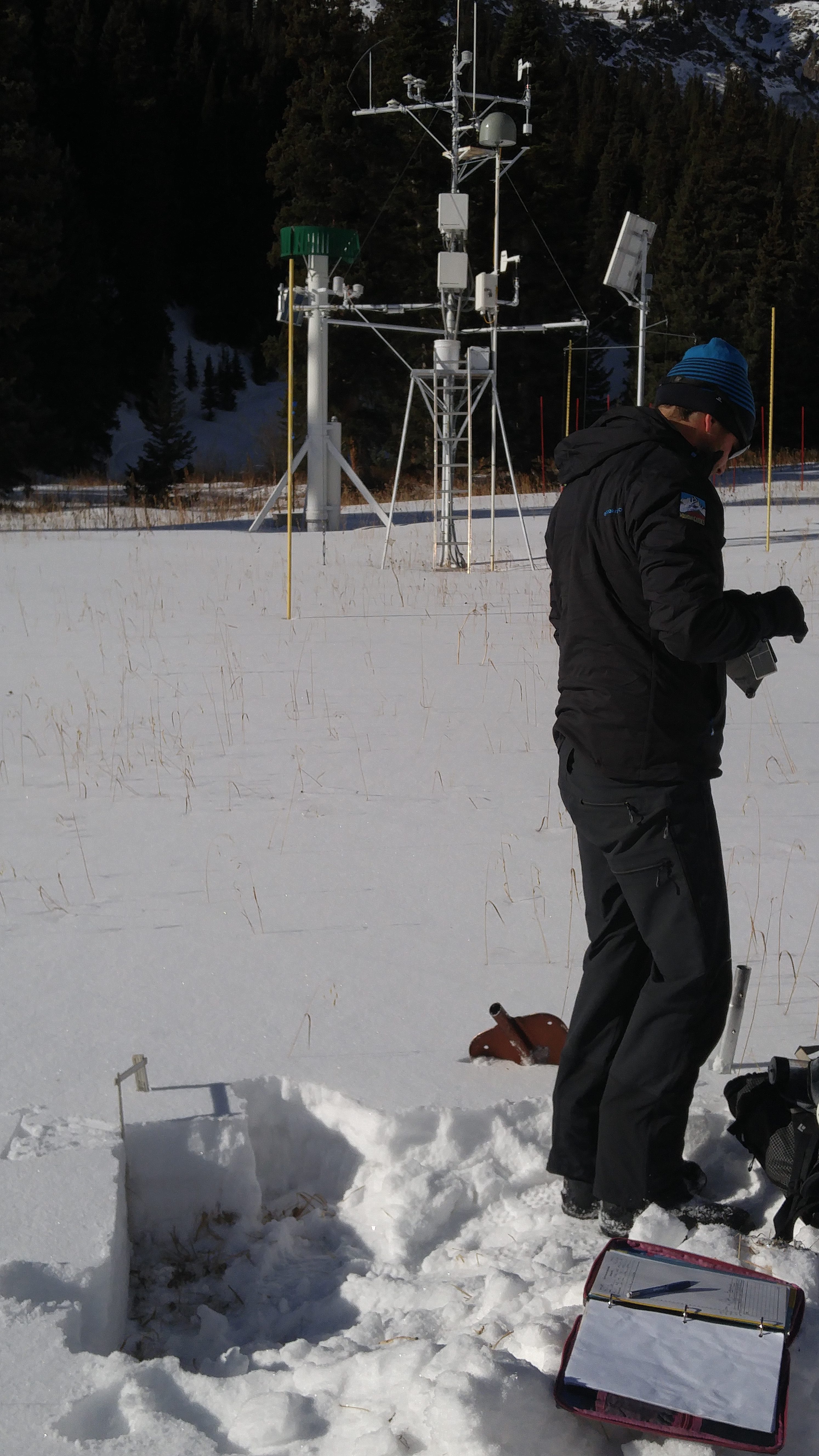 Photo: Snow profile at Swamp Angel on January 1, 2018.
Non-Storm Report #2: Early Season Weather Synopsis, December 9, 2017 Greetings from Silverton,
November was an uneventful month for precipitation in the San Juan Mountains. only 17mm of precipitation was received at the Swamp Angel Study Plot (SASP) and not a single winter storm event, as defined by CSAS criteria. Average temperature for the month at the SASP was just below freezing. The Senator Beck Basin remains snow free on all southeast through southwest aspects up to 13,000 ft. or higher and all snow in the basin is patchy, especially above tree line where windblown crusts are the dominant snow surface condition. As of the end of the month, Senator Beck Study Plot was snow free and SASP had only 6 in. (15cm) of snow on the ground. The snow that does exist, having been exposed for so long to temperature fluctuations and solar radiation, has been heavily metamorphosed into large grained facets and faceted crusts. So far the light snowpack remains dust free, although any dust-on-snow event at this stage in building the winter snowpack would be inconsequential to spring runoff.
This early season marks both the slowest start to winter and the driest November on the CSAS record. As of the end of November SASP had received 61 mm of precipitation, some as rain and mixed events, while the average water-year-to-date precipitation for that day is 192mm and the minimum on record prior to this year was 84mm in 2013. The average SASP precipitation for November alone in our period of record is 98mm, and the minimum on record prior to this year was 46mm in 2010. This put us at 32% of average water-year-to date precipitation and 17% of average precipitation for the month of November.
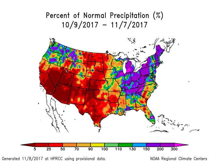
While not as dire as November, the month of October was comparatively dry as well. SASP received 44mm of precipitation, which is 46% of average (95mm) and makes this October the fourth driest on the CSAS record.
December is off to a dry start as well, with only 1mm of precipitation recorded at Swamp angel since December 1st. This dry pattern seems to hold through the middle of the month with the possibility of snow returning as the Holidays approach. While dry weather in the Four Corners area is typical of a La Nina year, which we are experiencing this season, this early start is notably dry compared to previous La Nina winters, as well as general trends in winter conditions for the CSAS period of record.
Non-Storm Report #1: The Snow Season Begins, November 9, 2017 Greetings from Silverton, Since October 31 Senator Beck Basin has received 29 mm (1.41″) of precipitation and roughly 5″ of snow accumulation. We start snow and storm record keeping the beginning of the winter season, defined as >50% of SBB being covered with persistent snow. The Halloween storm was a good start to the snow season, however following the storm a goodly amount of snow ablated from the landscape leaving near 50% or less snowcover remaining, leaving SBB and environs in a glass half full or half empty in terms of meeting the 50% criteria. Below is a plot of precipitation, collected at Swamp Angel (11,100′), and snowdepths at the Senator Beck Study Plot (12,200′) and Swamp Angel Study Plot going back to the Halloween storm. With 7mm (0.3″) precipitation and ~4″ added snow accumulation on November 7 we have now solidly started the winter snow season. We have also started to see the beginnings of snow accumulation at many SNOTEL stations across Colorado and hopefully we’ll see it stick around with more to come. The last month overall has been pretty dry overall. And the U.S Drought Monitor map is showing the Western third of Colorado as abnormally dry (http://climate.colostate.edu/~drought/), and the Southwest U.S. dust source region (Northern AZ, Southern UT) designated as D1-Moderate Drought. Expect to see Storm Reports this winter season whenever SBB receives 12mm or more precipitation with no gaps in precipitation greater than 12 hours. These Reports are also posted on our website: https://snowstudies.org/winter-storm-data/. If you know someone who would like to receive these Storm Reports, please have them contact me. 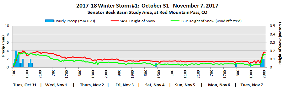
2016-2017 WINTER STORM REPORTS:
Storm Report #28: Rain on Snow Last Night Greetings from Silverton, Last night starting at 7 pm we received 0.47″ (12 mm) of precipitation over a 5 hour period at SASP. Judging by the air temperatures and lack of snow accumulation not only did it rain at SASP (11,060′) but also SBSP (12,186′), or at least came down as very wet snow. Air temperatures at SASP were warm, during the storm minimum hourly temps ranged 1-5 degrees C at SASP, and -0.2-3.5 degrees C at SBSP. As mentioned in the CODOS Update yesterday, when air temperatures begin to stay above freezing at night, the upper ~9″ of the snowpack does not re-freeze, with no energy required to go into the snowpack the next day to bring it up to the melting point, snowmelt essentially begins where it left off the day before. And indeed, warm daytime temperatures the last few days and also above freezing minimum temperatures the last few nights have kicked streamflow into action. Yesterday streamflow at Senator Beck slowly ramped up from 8 cfs in the morning to 16 cfs by 3 am this morning, undoubtedly aided by the fast moving, and high intensity storm (max intensity of 5 mm in one hour). Currently, flows have receded to 13 cfs. 
 Please see attached Storm Report. More soon. CSAS: Winter Storm #27 Greetings from Silverton, A very productive spring storm (number 27 for the season) impacted the entire state this past week. Here in the San Juan Mountains we picked up 36.8cm (14.5 inches) of new snow at our Swamp Angel Study Plot in Senator Beck Basin. 35mm (1.4 inches) of precipitation was associated with this snow. The warm weather that has been typical of this spring, with a few stormy periods, took a toll on the snowpack in the past weeks. Even though this storm brought a nice boost, we are now well past peak SWE at 11,000 feet in the Basin. Perhaps more important though is the covering of a significant layer of merged dust events, which had emerged prior to this storm. When the dust is on the surface it contributes to the acceleration of the melt season. We have received a nice “albedo reset” to slow down the melt. With warm temperatures and sun in the forecast for the rest of the month it is difficult to say just how long the dust will remain covered. As of now the forecast doesn’t show any significant precipitation in the next 7-10 days. See the full storm report attached below. More from Silverton soon. CSAS: Winter Storm #26 Greetings from Silverton, After a two-week break from major winter storms the atmosphere turned the faucet back on over Colorado. From May 9-11 the Senator Beck Basin picked up 29mm (1.1 inches) of precipitation as measured at the Swamp Angel Study Plot (SASP). This came as only 13.2cm (5.2 inches) of snow, indicating wet spring flakes and notable settlement during the 47 hour-long storm. The past week of very warm weather, which included two consecutive non-freezing nights at 11,000 ft. and saw re-emergence of two significant dust layers (D3 and D4) resulted in losses in snow height and snow water equivalent (SWE) in our snowpack. This storm did not add much in snow height, but brought SASP total SWE back up to near its level from before the warm spell. For the time being, those pesky dust layers are back under the nice white new snow. While it is still looking very much like winter at high elevations, the foreseeable future is looking warm and sunny, and with only a few inches of snow between the dust and the surface our snowpack may be dirty again soon. With a primarily isothermal snowpack at 11,000 ft. and a dusty surface on the way we expect to see the melt, which was put on hold during this past storm, to return. Keep an eye on our rivers for spikes in runoff, and expect more melt at higher and higher elevations as we move into the warmer spring period. See the attached storm report below. More from Silverton soon, Jeff Derry CSAS: Winter Storm #25 Greetings from Silverton, Winter Storm 25 was a piece of a large low-pressure system which passed through Colorado during the second half of last week. By our definition, this storm lasted 19 hours, leaving 15.7cm (6.2 inches) of snow at Swamp Angel Study Plot in the Senator Beck Basin study area. 15mm of precipitation total was recorded, all as snow. The higher elevation Senator Beck study Plot saw less than an inch of gain in snow height, likely due to redistribution by strong winds. After this winter storm ended (12 or more hours without new precip recorded) another pulse of precipitation brought 10mm more water to Swamp Angel. This did not meet our minimum 12mm precipitation threshold, but the notable point here is that this low-pressure system delivered 25mm (1″) of precipitation before moving east of the Rockies. The last 10 days of April we received a total 2″ of precipitation. Light instabilities persist over the San Juan Mountains, but will give way to very warm temperatures for the remainder of the week and weekend. Starting next week, we will see some cooling and chance precipitation. CSAS will be on the road over the weekend conducting our 3rd CODOS tour of the season, assessing dust and snowpack statewide. Look for our report on this upcoming tour at the beginning of next week, along with a pre-trip CODOS update, which will be out tomorrow. The full storm #25 report is attached. More from Silverton soon, Jeff Derry CSAS: Winter Storm #24 Greetings from Silverton, Winter storm 24 broke our April dry spell, bringing moderate precipitation to the Senator Beck Basin. Swamp Angel Study Plot picked up 17mm (.7 inches) of precipitation with 9.7cm (3.8 inches) of gain in snow height. However, some of this precipitation likely fell as rain early in the storm, and thin rain crusts were found within this new snow at the study plot yesterday. High winds and haze were observed in the San Juan Mountains prior to this storm, but no significant dust was recorded in our study basin. If dust was deposited on the snow surface prior to the storm, it was indistinguishable from our two events that were merged on the surface at the time, and likely a minor contribution to total dust for the season. There is significant dust in the snowpack at the Senator Beck Basin, much of which was exposed prior to this winter storm. This new snow, while not a major storm event, is providing an albedo reset for the region, burying the exposed dust, as well as insulating our isothermal snowpack and slowing springtime snowmelt. Our next winter storm has already begun, and is forecast to be a more significant system. Like storm 24, this incoming pulse of precipitation will likely favor the northern and eastern mountains of Colorado, but several inches of snow are expected in the San Juans as well. Weather will remain stormy on and off through the middle of next week before spring returns. Please see storm report attached. More from Silverton soon. Jeff Derry CSAS Winter Storm #23
Greetings from Silverton,
Our 23rd winter storm of the season was a productive system which deposited 20mm (0.8 inches) of precipitation in Senator Beck Basin in the San Juan Mountains of Southwest Colorado. This came as 26.6cm of low density snow. This system came predominately from the north and brought cold temperatures that contributed to the light, fluffy quality of the fallen snow. The storm came in without any dust, thankfully burying our three existing dust layers deeper in the snowpack. To continue the trend of the past few weeks, we have moved into another short lull in the storms. High pressure and clear weather will characterize the next few days and another stormy period is expected to begin this weekend as more moisture moves in from he Pacific. CSAS will be on the road this weekend for our second CODOS tour of the season, when we will assess the snowpack and current distribution of dust statewide. Look for a report on these observations early next week. Please see the full Storm #23 Report attached. More from Silverton soon. Jeff Derry CSAS Winter Storm #22
Greetings from Silverton,
Winter Storm #22 turned into an April fools joke that dragged on a little too long. With several long breaks that didn’t quite meet our threshold of 12 hours without precipitation to end the storm, this system persisted longer than anticipated with far less precipitation than forecasted. All told, over 57 hours the Swamp Angel Study Plot in Senator Beck Basin gained 17mm (0.7 inches) of precipitation as only 4.5 cm (1.8 inches) of snow. Because this storm was so long the new snow had ample time to settle throughout the storm, resulting in meager gains in snow height for the amount of water. This storm was forecast to be a major event for the San Juan Mountains in Southwest Colorado, as well as for the rest of the state. However, once the low-pressure system inched up into the Four Corners region, it was cut off from the jet stream. This unfortunately split its moisture into a meandering system that stumbled to our south and a more direct jet-driven pulse north towards Wyoming. Precipitation in Colorado was general seen in short bursts with long breaks and lower than expected snow totals. Some areas lucked out on highly zonal flow and picked up as much as 18 inches, but generally snow totals were only 3-6 inches statewide. Adding to the disappointing snow totals, the onset of this storm was accompanied by our third dust event of the season. D3 is a diffuse but highly visible layer, incorporated into the first inch of snow from Storm 22. We released a Dust Alert yesterday regarding this event. We will also be conducting our second CODOS tour in the next week, examining the extent of this season’s dust events statewide. Look for a report early next week. The weather has again begun to destabilize as another system moves into the region, and we expect to receive our next winter storm over the next few days. The full
Storm #22 Report is attached.
More from Silverton soon- Jeff Derry CSAS Storm #21, and another on the way
Greetings from Silverton,
Storm #21 (March 28-29) was just the remnants of Storm #20 (March 27-28). Please see the full
Storm #21 Report attached.
Another strong low-pressure system is moving our way and expected to be over the Four Corners early Friday morning. This system could bring over 16″-18″ to mountain areas. Expect another storm report soon. Below is where we stand for SWE at SASP. After this approaching storm we will be competing with WY2008 for the most SWE, for this time of the year.  More from Silverton soon- Jeff Derry CSAS Winter Storm #20
Greetings from Silverton,
Since Thursday, March 23, a series of productive, quick moving storms have given our Storm Report Department a lot of OT, with more to do before April based on the forecast. More precipitation is expected in the northwest San Juans tonight but since we have had a solid gap of precipitation greater than 12 hours, Storm #20 has officially come and gone. Last night Storm #20 started at 1800 and ended at 0200. We received another 9.2″ of snow accumulation and 0.7″ precipitation at SASP. The storm direction (mostly out of the south-southeast of all places) and milder wind speeds allowed almost as much snow accumulation at SBSP (8.4″). To keep the tally going, since March 23 we have received 35″ new snow accumulation and 3.1″ of precipitation at SASP. As a reminder, if you want to read old storm reports, you can find these on our snowstudies webpage:
https://snowstudies.org/storms.html. You may find the “Precip and Storm Report” spreadsheet on the webpage informative.
The full Storm #20 Report is attached. More from Silverton soon- Jeff Derry CSAS Winter Storm #19
Greetings from Silverton,
Winter storm 19 was a shorter-wave follow up to our last very productive winter storm. Quick on the heels of Storm 18, this most recent pulse brought steady overnight precipitation this past weekend, depositing 18mm (0.7 inches) of precipitation at the Senator Beck Basin as 20.8cm (8.2 inches) of snow. Since March 23 (Storm 18 + 19) we have received 2.4″ of precipitation and 25.8″ of total snow accumulation at SASP. Fortunately, it does not appear any dust came in with this storm, as it had for the prior two systems. Hopefully this storm can continue to serve as a nice “albedo reset,” burying dust layers deeper beneath the white surface and slowing down our recent accelerated melt. Our current weather pattern, delivering moisture from the north and west, will be back at it in no time. Weather models are currently in good agreement and suggest a barrage of short to medium wave troughs continuing to impact the state into the forecast-able future. The next system should arrive overnight Monday or early Tuesday morning and persist through Wednesday. Please see the full
Storm #19 report attached.
More from Silverton soon, Jeff Derry CSAS Winter Storm #18
Greetings from Silverton,
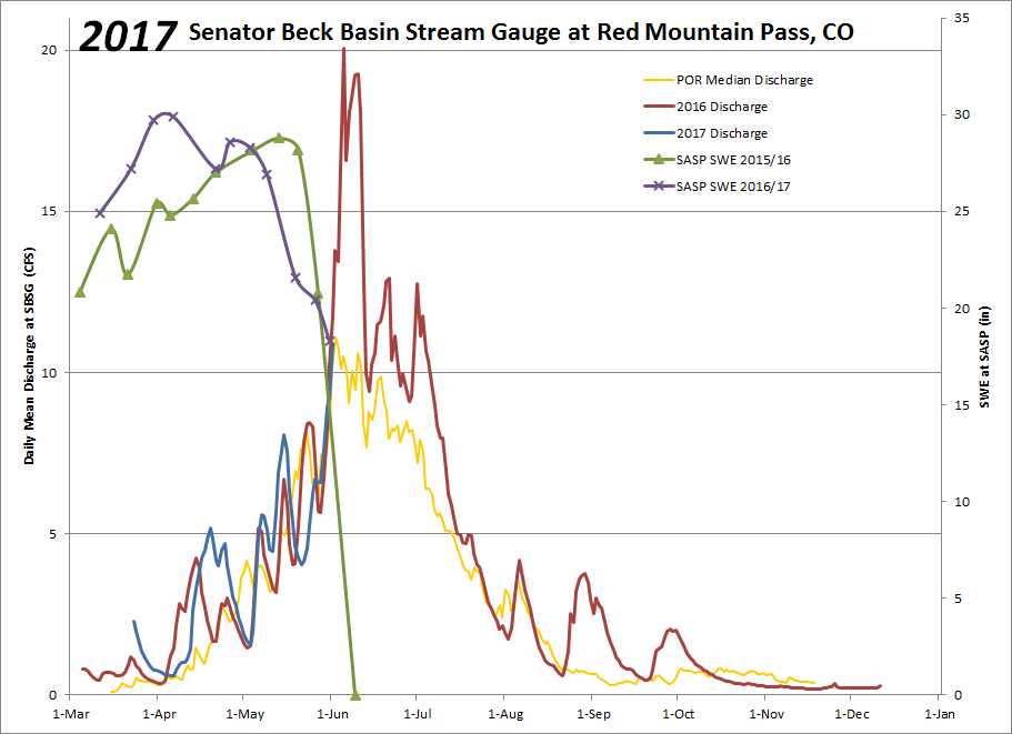
Winter storm #18 was a much-needed whopper. In only 26 hours the Senator Beck Basin in the San Juan Mountain of Southwest Colorado picked up 42mm (1.7 inches) of precipitation as 44.8cm (17.6 inches) of snow. This equates to a mean precipitation intensity of an impressive 1.62mm/hr for this storm, with a maximum hourly precipitation of 5mm! However, this storm also appears to have come in alongside our second dust event of the season (D2), which is now mixed with and lying under the thick, wet blanket of new snow. Leading up to this event model accuracy was limited and forecasted snow totals were all over the place. Fortunately we hit the jackpot, bringing in upper end quantities of precipitation and far outperforming the rest of the state. This forecasting difficulty is not atypical for northern events such as this one (see wind rose in attached storm report). The majority of our major precipitation events come from the Southwest through Northwest. Up until this storm March has been delivering record high temperatures and one emerged dust event. These factors have contributed to an unprecedented warming of the snowpack, leading to the earliest date of isothermal snowpack in our 11-year record (March 22nd). Accompanying this warming of our snowpack was a major surge in regional rivers and creeks. Below is a hydrograph for the month of March for the Uncompahgre River down stream of Senator Beck Basin, showing our above average discharge, as well as the decrease in flow accompanying this storm event.  The good news is that this storm event will slow down the process of “snowpack ripening” which contributes to loss of snow as liquid water. Additionally, we are at the onset of a pattern shift, which is expected to deliver several more pulses of unstable weather for the rest of the month and into early April. On Saturday, March 25th we received Storm #19, standby for that report. Please see the full
Storm #18 report attached.
More from Silverton soon, Jeff Derry CSAS Winter Storm #17
Greetings from Silverton,
Winter storm 17 barely tipped the bucket, delivering just 12mm (.5 inches) of precipitation to the Swamp Angel Study Plot in Senator Beck Basin as 12.5cm (4.9 inches) of snow. Strong southwest winds during the event redistributed nearly all of this snow above tree line. The high elevation Senator Beck Study Plot saw only a 0.3cm (0.1 inches) gain in snow depth during this event due to this significant wind transport. No dust has been observed in the snowpack in the San Juan Mountains, but reports of a potential dust event near Crested Butte have come in. These reports are spotty, however, regional wind trajectories suggest that it is possible for dust to have been transported from source regions in Northern Arizona to the Crested Butte area while the San Juan Mountains experienced more localized ground-level winds. Additionally, blowing dust was observed in Northeastern AZ over the weekend. Below is a figure generated by the HYSPLIT model (http://ready.arl.noaa.gov/HYSPLIT.php) showing 12-hour potential suspended particle trajectories centered around the time that blowing dust was observed in AZ and ending at the Senator Beck Study Plot (southwestern star) and the Park Cone SNOTEL (northeastern star) sites. That time also roughly coincides with the start of this winter storm, and it is common for a “wet” dust event to arrive around the onset of snowfall. You can see that while the Senator Beck Basin is not indicated to have been the destination for any long-range transport, the Park Cone site could have been a deposition zone. There is no substitute for going out and digging a hole in the snow. CSAS will be conducting the first statewide CODOS tour early next week, when we will assess the snowpack for potential dust deposition and evaluate the current state of the snowpack. Please see the full
storm report attached.
More from Silverton soon, Jeff Derry 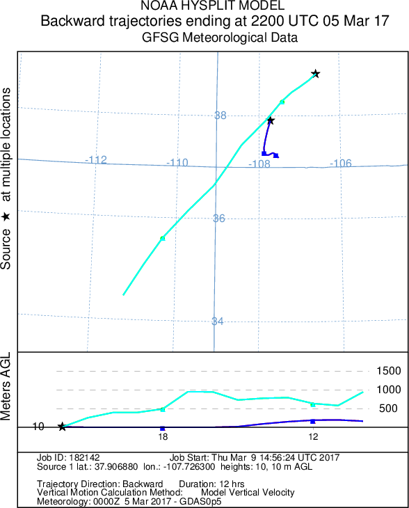 CSAS Winter Storm #16
Greetings from Silverton, Over 40 hours the Senator Beck Basin in the San Juan Mountains received 24mm (.9 inches) of precipitation as 24.1cm (9.5 inches) of snow. The storm pushed our already deep snowpack soundly over the 2-meter mark. The Basin is sitting well above average for snowpack for this time of year.
This storm deposited snow erratically across the San Juans, with highly varying storm totals in a relatively small area. Wolf Creek and Silverton Mountain are both reporting 30-inch storm totals, and telluride is reporting 20 inches. Winds at Putney Study Plot during this event were from the Northwest and Southwest, with very little west wind. We are expecting a dry spell for the beginning of march with the chance for some precipitation coming in around Monday the 6th. The next significant snowfall in Southwest Colorado is expected at the end of next week. Yesterday we released our annual March 1st snowpack update, addressing snowpack conditions in Senator Beck Basin and statewide, as well a projections for the rest of the snow season. It is available here: http://www.codos.org/codosupdates/mar12017. See the attached storm report for Winter Storm #16. More from Silverton soon- Jeff Derry CSAS Winter Storm #15
Greetings from Silverton,
Winter storm #15 was the latest in a series of moderate precipitation events to impact the Senator Beck Basin in the San Juan Mountains. Over 42 hours the Swamp Angel Study Plot received 20 mm (.8 inches) of precipitation as 18.7 cm (7.4) inches of snow. The wind affected Senator Beck Study Plot gained 12.9 cm (5.1 inches) of snow. There is more snow in the forecast for the next few days, and then the beginning of March looks to be dry for now. Forecasts for these upcoming pulses of precipitation are variable, but will likely be similar events to our past few moderate snows. Our snowpack in Senator Beck Basin is currently well above average for this date, with no observed dust layers. On March 1st we will issue a comprehensive report on the state of our snowpack in the Senator Beck Basin and in other watersheds statewide. The full
storm report is attached.
More from Silverton soon- Jeff Derry CSAS Winter Storm #14: Possible Dust
Greetings from Silverton,
Storm 14 rolled through the San Juan Mountains this past weekend leaving 17.5 cm (6.9 inches) of snow with 17mm (.7 inches) of water at the Swamp Angel Study Plot in Senator Beck Basin. The more wind affected Senator Beck Study Plot saw 24.3 cm (9.6) inches of new snow. This was the most recent storm in a series of light to moderate producers to strike the region. Storm 14 came mostly out of the south, and reported snowfall across the San Juan Mountain Range was variable. While the storm ended on Sunday evening, lingering precipitation through Monday deposited an additional 7mm of water, which is not reflected in this storm report. While the Senator Beck Basin has not seen a major storm event since the end of January, this incremental loading continues to build our snowpack. The Basin is well above average for mean snow water equivalent (SWE). This trend is similar throughout Southwest Colorado. We have had reports of a dust event preceding this storm, although we have not observed dust in the snowpack at SASP, we are ascertaining the possibility of an unevenly distributed event. If you have observed dust-on-snow, and feel it is not from a local source, please send me an email and a picture would be great. The
Storm #14 Report is attached.
More from Silverton soon- Jeff Derry CSAS Winter Storm #13
Greetings from Silverton,
Storm #13, occurring February 7-8, did not deliver the snow totals as predicted at SBB. We were expecting about 1′ of new snow but Swamp Angel received only 15 mm (0.6″) of precipitation and 5.2 cm (2″) of new snow accumulation (with a good amount of graupel). There was a 15 hour period where winds speeds gusted 50-80 mph out of the west/northwest. And warm, the first 5 hours maximum air temperatures were just barely below 0 C, with the remainder of the storm averaging -2.3 C. Today is a beautiful day. The next low pressure arrives Friday night, with the forecast to bring precip into Sunday. The Storm #13 Report is attached below. More from Silverton soon, Jeff Derry CSAS Winter Storm #12
Greetings from Silverton-
A short wave trough moved in on the heels of our last long and productive winter storm, and lingering precipitation tipped the scales giving us another recordable storm event. Winter Storm #12 lasted 42 hours and delivered 16mm (0.6 inches) of precipitation to the Senator Beck Basin in the San Juan Mountains. A notable oddity about this storm was a loss in snow height during the storm of 1.5 cm (0.6″). Because Winter Storm #12 began only 12 hours after the previous storm, the new snow was still in a period of settlement. With low precipitation intensity, Storm #12 was unable to deliver new snow as fast as the old snow settled, resulting in a gain in snow water equivalent yet a loss in total snowpack depth. With this last little pulse departing the region. The weather has turned dry and cold. Temperatures will rise in the next few days but a long wave ridge will deliver sustained stable weather well into next week. Enjoy the sunshine. Recap of December and January December and January were productive months for snow at the Senator Beck Basin Study Site. Snowpack is well above average for this time of year. No dust has yet been observed in the Senator Beck Basin. December brought 17 out of 31 days of precipitation and 4 winter storms. During the month 134mm (5.3 inches) of precipitation was recorded. January was a very wet month with 22 out of 27 days (so far) with recorded precipitation, with 5 winter storms delivering a total 203mm (8.0 inches) of precipitation to the basin. Current snowpack at the Swamp Angel Study Plot is just under 2m (6.6′), and year to date precipitation is 470mm (18.5″). A complete Storm #12 Report is attached below. More from Silverton soon, Jeff Derry CSAS Winter Storm #11
Greetings from Silverton-
The past week has seen multiple systems impact the San Juan Mountains in Southwest Colorado. Three individual pulses of unstable weather associated with an overarching low pressure system brought snow to the region. The first of these pulses brought only 8mm (.3 inches) of water to Senator beck basin, and was followed by a break in precipitation of more than 12 hours, so is therefore not part of this report. The second and third waves of this large scale system comprise our 11th winter storm of the season. Storm 11 was a slow burner with periods of heavy precipitation in between long periods of mild snowfall. All told, Senator Beck basin picked up 38.7 cm (15.2 inches) of snow with 52mm (2.0 inches) of total water over its 74 hour duration. While that might not seem like much snow for that amount of precipitation, keep in mind that with these long duration storms the snow is given ample time to settle under it’s own load. Our storm total reflects this final storm total with settlement. While it is currently snowing in Silverton, It is unlikely that the current precipitation will amount to another winter storm. Once these flurries move out expect relatively dry weather through the rest of the month. Please see the attached Storm #11 Report below. More from Silverton soon, Jeff Derry CSAS Winter Storm #10
Greetings from Silverton-
Winter storm number ten baffled four corners forecasters. Cut off from the main flow of weather, this low-pressure system wandered aimlessly around the Gulf of California and Southwest States. The system was met with considerable moisture and camped out over Colorado for a few days, depositing snow across mountains statewide. All told, the Senator Beck Basin in the San Juan Mountains received 1.3 inches of precipitation as 12.3 inches of snow. Because the storm was isolated from the jet stream, winds were relatively moderate during this storm compared to most other events so far this winter. Unfortunately, our precipitation gauge was out of commission during the first part of the storm. For that reason, hourly precipitation prior to 1200 on Friday, January 13 is read from the nearby Red Mountain Pass Snotel. All snow height information is accurate and read from the Swamp Angel Study Plot for the duration of the storm. The cutoff storm continues to linger over parts of the state, so although the storm is over expect light flurries on and off with dry weather dominating the short term forecast. A new system is expected to impact Southwest Colorado later this week and into the weekend. See the attached full Storm Report for winter storm #10. More from Silverton soon, Jeff Derry CSAS Storm #9, Jan 8-9
Greetings from Silverton,
While storm number nine did not hit Colorado quite as hard as it hit the West Coast, Senator Beck Basin near Red Mountain Pass in the San Juans still picked up nearly a foot of heavy snow. Total storm snow depth at Swamp Angel was 10.5 inches with 1.5 inches of precipitation. While some precipitation has continued through the region, the isolated system of low pressure and high moisture that brought us storm number nine has left the region. Another system has already entered the four corners area mid day Wednesday, bringing notable atmospheric lift and water. About 0.2 additional inches of precipitation was recorded between these storms. This interesting incoming storm broke loose from the major storm track and is now slowly meandering around the Southwest states and the Gulf of California. Because this storm has parted with the main (and more predictable) flow, it is hard to predict how much it will snow, but the San Juans already picked up a couple inches as of Wednesday evening. Keep an eye out for another storm report once this system moves through the region. Please see attached Storm Report #9. More from Silverton soon, Jeff Derry CSAS Storm #8: Another Productive System
Greetings from Silverton,
We logged Storm #8 in Senator Beck Basin these last couple days. Like previous storms these past 5 weeks, this one came with high winds out of the west-southwest with gusts up to 83 mph at Putney met station. Blowing and redistribution of snow above treeline has been intense these past few weeks. The eight storms in and of themselves have brought ~10″ of water, measured at Swamp Angel Study Plot. YTD cumulative precipitation at Swampy is 12.3″, and at nearby Red Mountain SNOTEL it is 12.8″. Please see attached Storm Report. More Soon, Jeff Derry CSAS Storm #7: Dec 24-25
Greetings from Silverton,
Attached are the details for Storm #7 that came through over Christmas. Like other recent storms, this one brought high winds, gusts up to 96 mph out of the SW at Putney. I love it when the NWS uses the phrase “active weather pattern”, that is the phrase being used to describe this weekend and into the New Year. Please see the 7 day outlook below. 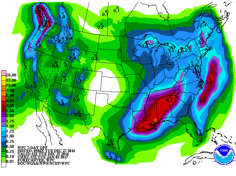 More Soon, Jeff Derry CSAS Storm #6: Xmas Bonus
Greetings from Silverton,
Storm number six was a holiday surprise! Originally forecast to swing far south into Mexico, this little low-pressure system tracked back north out of the Gulf of California and plowed right through Colorado instead. This storm came almost due out of the south, and the San Juan Mountains were favored statewide. The southern San Juans stole the show with storm snow totals at Wolf Creek double those of Red Mountain Pass. All told the Senator Beck Basin picked up 8 inches of relatively dense snow, at least by Colorado standards, with 0.8 inches in snow water equivalent. The atmosphere is wasting no time delivering another round of gifts to the state. A major storm system is moving in over the weekend. There is a HUGE amount of moisture associated with this next system, which means snow totals could easily exceed the forecast. Either way, expect strong winds and heavy snowfall through the weekend. Please see attached Storm #6 Report. More from Silverton soon, Jeff Derry CSAS Storm #5: A Big One
Greetings from Silverton,
Our fifth winter storm of the season laid a thick blanket of snow across the San Juan Mountains.This productive system brought extreme winter weather conditions to the entire state, delivering brutal cold, severe winds and significant precipitation. Winter storm #5 arrived earlier and stayed longer than originally forecast.Over the storms 62 hours the Senator Beck Basin saw temperatures plunge well below 0F, winds gust over 90 mph and a near doubling of snow depth in some locations. Precipitation totaled 2.3″. An unexciting jet stream will deliver stable weather to the San Juans this week. Our next chance for precipitation looks like flurries to kick off the weekend and a stronger system moving into the region early next week. For now, enjoy the sun! The full Storm #5 report is attached. More from Silverton soon, Jeff Derry CSAS: Storm #4
Greetings from Silverton,
On Sunday we saw a 10-hour storm bringing 22 mm (0.9″) precipitation accompanied by up to 70 mph wind gusts. The last few weeks have experienced active weather patterns. Storms across eastern Utah and western Colorado will be back on the radar late Tuesday and Wednesday, and then again over the weekend that should bring more mountain snowfall. Please see the Storm #4 report attached. More Soon, Jeff Derry Center for Snow: Storm #3
Greetings from Silverton,
Yesterday we saw the remnants of the last leg of a four day storm tapper off. The storm comprised of a few different systems stacked pretty close together. On Saturday the storm(s) were ushered in for 7 hours with strong winds out of the south, with gusts averaging around 49 mph (22 m/s) while 0.67″ (17 mm)precipitation fell. Then the wind shifted out of the SW-W for the next 12 hours with gusts still remaining around 43 mph (19 m/s) but with precipitation tapering off to 0.2″ (5 mm) for the period. From there, winds stayed out of the WNW-N for the remaining 56 hours with gusts gradually lessening to around 25 mph (11 m/s). Precipitation remained pretty consistent throughout, the longest period without precipitation was 5 hours on Monday morning. These storm events helped seriously kick start formation of the snowpack after a long dry spell (besides the ~2″ of precipitation from the Nov. 17 and Nov. 20-22 storms) going back to September. Senator Beck Study Basin received a total of 2″ (52 mm) precipitation from Storm #3 with some areas of the San Juans receiving 3″. Pretty much the entire western half of Colorado is considered abnormally dry and most of the eastern half of Colorado is considered in moderate drought conditions by the Colorado Climate Center. Below, based on SNOTEL data, is the snow water equivalent percent of median conditions for the major Colorado river basins, as of November 30, 2016. 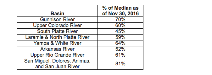 The current outlook (below) indicates Colorado receiving less than 1″ new precipitation next week. Thursday/Friday the central and southern mountains may see 3-6″ of snow. The NWS reports a strong trough bringing precipitation to eastern Utah and Western Colorado by early Monday morning through daybreak Tuesday. The models are in disagreement as to where the system moves from there, but they do agree that cold air will be plentiful starting Tuesday. Please see the attached storm report. More Soon, Jeff Derry CSAS Storm 1 & 2: A Taste of Winter
Greetings from Silverton,
Well we finally received enough snow here at Senator Beck Study Basin, near the summit of Red Mountain Pass, to say that winter is underway. The Center for Snow defines the start of the snow season in Senator Beck as at least 50% of the Basin being covered with persistent snow. Monday, November 21 defines this day, arriving a little late but most welcome. Starting Thursday, November 17, we received two storms, the second storm ending Tuesday, November 22. I am issuing Storm Report #1 a tad late, we had a number of days where our very fragile phone line that transmits data from our meteorological stations to the office was waiting to be repaired. You got to appreciate a phone service technician who carries snow shoes in his truck and is not afraid to use them. The first storm, coming in from the north/northwest and lasting the day of Thursday, Nov. 17, brought 15 mm (0.6″) precipitation. The second, lasting Sunday, Nov. 20 – Tuesday, Nov. 22, came in from the southwest and delivered 33 cm (1.3″) of precipitation. No dust was observed being deposited from this event. Please see the attached Storm 1 and Storm 2 reports. We are in an “active” period for potential precipitation events. A quick moving storm is expected to come through later today and tomorrow. The next system is expected to arrive over the weekend. Have a Great Thanksgiving! More soon, Jeff Derry
2015-2016 WINTER STORM REPORTS:
CSAS Storm #24
Greetings from Silverton,
The stormy weather over the last few days has brought Storm #24 here at out Swamp Angel Study Plot (SASP). Precipitation mostly fell as rain at SASP (11,060′) while at the Senator Beck Study Plot (12,180′) it appears to have been mostly in the form of snow. Today thru Thursday night the chance of precipitation remains 30%-70% with conditions expected to dry out later this week. A complete Storm #24 report is attached. More Soon, Jeff Derry CSAS Storm #22 and #23
Greetings from Silverton,
The active weather systems over the last few weeks have helped southern Colorado make up for the February to mid-March dry period. Over the last few days it has been cloudy with frequent rain and snow here in Silverton and at our Senator Beck Study Basin. Since Friday we have received a total 2″ of precipitation. Since April 23, we have received 4.2″ of precipitation. The precipitation has been falling as moist snow at higher elevations and rain/snow everywhere else. Storm #22 occurred Sunday, May 8 thru the afternoon on Monday, May 9. That storm event was out of the southwest and totaled 1.1″ of precipitation.Storm #23 occurred Tuesday, May 10, and was out of the W-SW. This event brought 0.8″ of precipitation. The full Storm #22 and Storm #23 Report is attached. Below is the precipitation outlook for the next 7-days. More Soon, Jeff Derry  CSAS Storm #20 and #21 at Senator Beck Basin
Greetings from Silverton,
Since Monday, April 25, Senator Beck has received a steady stream of precipitation, and, as I write this e-mail it is snowing and expected to continue through Monday, dissipating into Tuesday morning. This weeks precipitation has consisted of several back-to-back synoptic scale systems that have not allowed a break greater than 12 hours between events. It is the first time this WY2016 season this has happened. Our storm definition, at least 12mm of precipitation with no break greater than 12 hours, has been tweaked to better reflect, with hopefully a little better accuracy, the number of storm events we have been receiving. The first storm is defined as occurring from 1200 MST Monday, April 25 to 2400 Tuesday, April 26. The second storm is defined between 0700 Wednesday, April 27 to 0200 Friday, April 29. All total, from April 25-30, Senator Beck received 1.9″ of precipitation. The NWS forecasts calls for a high pressure dominating late Tuesday thru Wednesday night. The next strong low will move onshore Thursday and be in the Four Corners Regions Saturday afternoon. The full Storm #20 and Storm #21 reports are attached. More Soon, Jeff Derry CSAS Storm #19: 1.5″ Precip at SASP April 15-17
Greetings from Silverton,
The lingering state-wide Spring storm seemingly left the San Juan region a little earlier than expected, but just as I was about to send out this report for Storm #19, our Swamp Angel Study Plot received 5 mm (0.20″) of precipitation and 10 cm (4″) of addition snow accumulation. The official storm occurred April 15-17. High winds out of the SW ushered in the storm in some areas of the State but as of right now we are reasonably sure a new dust event did not accompany. The official precipitation total is 38 mm (1.5″), if we include all the spits of moisture received outside the storm duration, the precipitation received at SASP is 44 mm (1.7″). SASP accumulated 33.5 cm (14″) of snow and SBSP 29.4 cm (11.6″). A nice dose of precipitation, most definitely needed especially in the Southern Basins. Hopefully we’ll see a few more of these events before winter completely bids us farewell. Storm Report #19 is attached. More Soon, Jeff Derry CSAS Storm Report #18
Greetings from Silverton,
Storm #18 officially came through Senator Beck Basin starting between 1500-1600 on Monday, March 28 thru 400 Wednesday, March 30. The storm was preceded with strong S’ly winds and high winds continued while the snow fell. The first 28 hours of the storm the average hourly gust was 63 mph, creating real blizzard like conditions at times in Silverton and surrounding areas. We received 9.7″ (24.7 cm) of new snow accumulation and a solid 1.0″ (25 mm) of precipitation. On Wednesday, March 30, around 7:00am the winds shifted out of the North. We continued to see another 0.24″ (6 mm) of precipitation until late Thursday night, but there was a gap of precipitation greater than 12 hours thus ending the official duration of the storm. The week to come looks pretty tame with only a 20% chance of precipitation in the Silverton area, snow showers, in the 2-5″ range look to favor the north and central mountains. The full Storm #18 Report is attached. More Soon, Jeff Derry CSAS Storm Report #17
Greetings from Silverton,
Friday night through most of Saturday we received 6″ of new snow accumulation and 0.7″ (19 mm) of precipitation. Not much but we’ll take it. Winds were out of the WNW-NNE. A full report for Storm #17 is attached. Looking ahead……A cold front preceded by gusty winds is expected to come into western Colorado Monday and Tuesday. The system is creating wind and dust advisories for many areas including SW Colorado and possibly Grand Valley. The forecast calls for areas of blowing dust starting Monday going into Monday night. Snow is expected to start Monday night and go into Wednesday. 4 to 12 inches are possible for the mountains of western Colorado. More Soon I Hope, Jeff Derry CSAS Storm #16: March 22-23
Greetings from Silverton,
A couple days ago we hit Storm #16 here at Senator Beck Basin. On Tuesday, March 22, the storm started out of the SW bringing light dust to Senator Beck and heavier amounts of dust to the eastern San Juan Mountains. The wind then shifted out of the WNW to N and it began snowing until 1900 on Wednesday, bringing 12.6″ (32.1 cm) of new snow to our now 5.2′ (1.57 m) snowpack at SASP. Please see a full report attached. More soon, Jeff Derry CSAS Storm Report #15: March 6-8
Greetings from Silverton,
Our first storm of March WY2016 moved east of our Study Basin early this morning. This was a wet two day storm with average 17 mph winds (peak gusts up to 72 mph) out of the SSW. The NWS indicates a closed low over Mexico will move through today/tonight with a forecast of scattered precipitation and isolated heavy bursts of snow above 9,000′. The next 7-10 days is expected to bring an unsettled pattern with a closed low just south of the Four Corners Saturday/Sunday bringing some precipitation to our area and next week (Monday/Tuesday) we are to expect a long wave trough bringing widespread showers, it is still unclear as to the intensity and extent of these systems. Storm #15 Report is attached. More Soon, Jeff Derry CSAS Storm Report #14
Greetings from Silverton,
Quick moving Storm #14 came through the Senator Beck Study Area starting Monday morning and passed Tuesday afternoon. The Storm brought 21.1 cm (8.3″) of new snow accumulation, enough to cover D2, the second dust-on-snow event for WY2016, for the time being. Winds were pretty calm and out of the NNE for the duration. A persistent ridge has settled over the area bringing a dry warming trend. The next chance for precipitation is not until Monday/Tuesday. Storm #14 Report is attached. More Soon, Jeff Derry CSAS Storm #13 at Senator Beck Basin
Greetings from Silverton,
Productive Storm #13, lasting 82 hours, ended yesterday afternoon. We received 55 mm (2.2″) of water content at SASP. Wind direction was out of the S-SW for the bulk of the storm, with speeds consistently 22-45 mph, and shifted out of the north on the last day. With the passing storm we now have frigid temperatures in the minus 20’s (Celsius) at night and in the minus high teens during the day. The complete Storm #13 Report is attached. More Soon, Jeff Derry CSAS Storm #12 at Senator Beck Basin
Greetings from Silverton,
Yesterday evening Storm #12 came to an end. This was a 34 hour storm that brought 24 mm (0.9″) of water content to SASP. Average wind speeds of 7 m/s (15.7 mph) were out of the NW to NNE for the duration of the storm. For the month of January alone, we have received 76 mm (3″) of precipitation. Our YTD total is now up to 518 mm (20.4″) of cumulative precipitation at SASP. A complete Storm #12 is attached. More soon, Jeff Derry CSAS Storm #11: 1-Day Wallop
Greetings from Silverton,
Yesterday, Wednesday January 20, we experienced a quick moving storm system passing through the San Juan Mountains. In 22 hours it brought 17 mm (0.7″) of water equivalent and 17 cm (6.7″) of new snow to Swamp Angel Study Plot near the summit of Red Mountain Pass. Storm #11 Report is attached. Today is a blue bird day with the wind wisping the snow over and around the peaks. More Soon, Jeff Derry CSAS Storm Report #10
Greetings from Silverton,
On Sunday at 3:00pm, Storm #10, lasting 59 hours, ended bringing 35 mm (1.4″) of water content to Swamp Angel Study Plot. I was expecting to compile the Storm Report on Sunday, but the precipitation kept coming until late Sunday afternoon. The storm systems that passed through brought 12 mm of precipitation on Friday, 10 mm on Saturday, and 13 mm on Sunday. Starting on Saturday at 3:00pm thru Sunday at 9:00am, average wind speeds kicked up to 13 m/s (29 mph), with average peak gusts of 19 m/s (43 mph), and max peak gust of 27 m/s (61 mph), redistributing the freshly fallen snow most noticeably in terrain above treeline. A complete Strom #10 Report is attached. Jeff Derry Winter Storm #8 and Storm #9: December 19-25, 2015
Greetings,
As we all know, the Colorado mountains, including Senator Beck Basin and Red Mountain Pass, received a very nice bump in snow accumulation over the last 7 days. By definition (at least 12 mm of precipitation with no more than 12 hours without recorded precipitation), we saw two storms pass through since December 19. The first storm event occurred December 19 through December 23. After approximately 15 hours, Storm #9 moved in December 24-25. Precipitation totaled over 4″ of water equivalent for both storms with 30″ of new snow at SASP – This was a major event. Winds were strong (particularly for Storm #9) out of the S thru W-NW with gusts greater than 60 mph. Even with a fair amount of wind erosion, 20″ of snow accumulated at SBSP (12,180′). This Tuesday morning another system is expected to pass the four corners region, bringing an increasing chance for snow, although significant accumulation is not expected with this system. A complete report for Storm #8 and Storm #9 is attached. Happy Holidays, Jeff Derry CSAS Storm #7 Report: December 14-16
Greetings,
34 hours after Storm #6 (December 11-12) ended, storm #7 rolled into town for 41 hours and delivered 25 mm (1 in) of precipitation, officially ending Wednesday at 1:00 am. Total precipitation received over the last 7 days is 50 mm (2 in), and we now have 1 meter of snow at SASP. A complete Storm #7 report is attached. Take Care, Jeff Derry CSAS Storm #6 Report
Greetings from Silverton,
Storm #6 began late Friday, December 11 and ended Saturday, December 12. Lasting only 24 hours and delivering 17 mm (0.7 in) of precipitation. We are likely going to see another storm this week, the forecast calls for 6-12″ of new snow accumulation. A complete Storm #6 report is attached. More Soon, Jeff Derry Winter Storm #5: November 15-17, 2015
Greetings from Silverton,
It’s a calm (29 F) and partly sunny day here in Silverton. Storm Report #5 is attached for winter 2015/2016 thus far. This Storm started with some intensity for the first 8 hours and then tapered to mostly 1-3 mm/hr of precipitation for the remaining 24 hours. This was a significant precipitation event with a total gain of 54 mm (2 inches) of water content at SASP. Snow depth at SASP increased 53 cm (21 inches), and 31 cm (12 inches) at SBSP. This storm had periods of high peak gusts and periods of high sustained winds. See the variable SBSP snow plot (above treeline) compared to the SASP (below treeline) in the attached pdf. For three hours early Monday (Nov 16) morning gusts ranged from 23-41 m/s (52-91 mph) from the S-SW. Then, for 17 hours beginning at 2100 on Monday, peak gusts were sustained between 14-22 m/s (32-50 mph), with average gusts for this time period of 19 m/s (42 mph), from the N. Our Water Year total precipitation is 236 mm (9 inches). We are above the 11 year average of 191 mm (7.5 inches) collected by the end of November. More Soon I Hope, Jeff Derry CSAS Storm #4
Greetings from Silverton,
Storm #4 came between 1500-1600 hrs MST Tuesday, November 10 and left 1600 hrs MST Wednesday, November 11. SASP snow depth increased 24.4 cm (9.6 inches), current total snow depth is 45 cm (17.7 inches). SBSP was wind affected gaining only 1.3 cm (0.5 inches) of snow. The storm brought approximately 18 mm (0.7 inches) of precipitation. A pesky spruce needle got stuck in the check-valve of the precipitation gauge, so precipitation totals were reconstructed using nearby SNOTEL data. A complete Storm #4 report is attached. Take Care, Jeff Derry Building the Snowpack – Storm #3
Greetings from Silverton –
Last week we saw Storm #3 which started late evening Tuesday and ended early eveningThursday. A power failure resulted in a data glitch, delaying the creation of this report. Storm #3 totaled 36 mm (1.4″) of water content, our water year total precipitation is now 163 mm. Rather high winds accompanied this storm with average speeds of 20 mph with gusts up to 67 mph. Swamp Angel (elevation 11,060′) saw the snowpack increase 34 cm (13.5″). Senator Beck (elevation 12,180′) saw an increase of 24 cm (9.4″). The forecast is for a fast moving storm to move in late this afternoon. Snowfall is expected to increase and peak overnight/tomorrow morning, and exit the area by Wednesday. Anticipated snowfall will be half a foot to over a foot. You will likely be seeing another CSAS storm report soon. Attached is a PDF with Storm #3 details. More soon, Jeff Derry Snowcover begins in Senator Beck Basin Greetings from Silverton – Over the past week the western San Juan Mountains have begun developing the Winter 2015/2016 snowpack. Two back-to-back storms, recorded as CSAS Winter Storms #1 and #2, have produced enough snowcover to persist over at least 50% of Senator Beck Basin henceforth, even if we have a subsequent dry and sunny period. Storm #1, October 18-20, fell as mixed precipitation at Swamp Angel Study Plot (11,060′), without any accumulation of snow, but did fall as primarily snow at the higher Senator Beck Study Plot (12,180′). Storm #2, October 22-23, fell as snow at both study plots. Neither Storm was particularly intense, with only moderate winds and precipitation intensity. CSAS looks forward to receiving a more normal quota of Winter Storms here in the San Juan Mountains this season, at somewhere around 25 total storms, as opposed to the poor total of only 18 Winter Storms last season. We will soon (in early November) be adding a new chart of “Cumulative Winter Storm Count” data to our graphed precipitation webpage
2014-2015 WINTER STORM REPORTS:
Recent rain event, streamflow effects June Greetings from Silverton – Last Friday, Saturday, and Sunday June 5-7, we logged a total of 39 mm of precipitation (15 mm 6/5. 23 mm 6/6, and 1 mm 6/7) at the Swamp Angel Study Plot (SASP) at Senator Beck Basin. Given steadily rising streams in the days prior to this event, including our own Senator Beck Basin runoff, there was concern that additional snowmelt from rain-on-snow could result. At the SASP elevation, 11,060′, almost all of this fell as rain or mixed rain/sleet and we gained no additional depth of snowcover at SASP. At the higher Senator Beck Study Plot (SBSP at 12,180′) some fraction of this precipitation fell as snow and we did gain 10 cm (4″) of snow depth there. Snowline in the Red Mountain Pass locale was at about 11,000′ prior to this storm so the Senator Beck Stream Gauge, at 11,040′, was well positioned to assess the impact of this rain on snowmelt runoff, and the contribution of snowmelt to any change in Uncompahgre River flows as measured at the USGS Uncompahgre River Near Ridgway gauge. During this rain event, streamflow measured at our Senator Beck Stream Gauge actually declined, from a 24-hour mean of 12.82 cfs for June 4, the peak flow for the season to-date, down to 9.23 cfs for June 7. 24-hour mean air temperatures remained above freezing throughout the rain event, at both SASP and SBSP. Also during this event, 24-hour mean incoming solar (shortwave) radiation plunged from averaging near 400 w/m2 on June 2,3 and 4 to 119 w/m2 on June 5 and 173 w/m2 on June 6. This is the straightforward impact of heavy cloud cover. Those same clouds, however, were emitting thermal (longwave) radiation that did contribute energy to the snow surface energy budget throughout the event, especially at night. Overall, though, the loss of solar radiation resulted in a net reduction in radiative forcing of snowmelt. At the USGS Uncompahgre gauge, streamflow was slightly declining on June 3-4 following a peak of near 640 cfs on June 3, as the most vulnerable snowpack was being rapidly depleted. Then, flows rose again to the season-to-date peak of near 700 cfs on June 6. (All this behavior was at flow levels that exceeded the median discharge levels for those dates and followed a very steep surge in flows in late May.) Despite almost entirely above-freezing air temperatures throughout the rain event period, and the additional thermal energy contained in the rain falling on snow (even the sleet was at 0 C and did not significantly cool the snow surface), the loss of energy from direct solar radiation was too much for the other factors in the snow surface energy budget to overcome, and snowmelt rates declined. It seems, then, that even with significant amounts of rain-on-snow, at most elevations of snowcover, the uptick in Uncompahgre River flows was rain driven, and that the additional flows produced by rain on the non-snowcovered terrain below 11,000′ offset the decline in flows from snowmelt. That’s enough on this for now … the somewhat counterintuitive outcome of this rain-on-snow event deserves more thought and you may have seen somewhat different outcomes in your locale. Now it looks like we’re in for a repeat rain event, so we’ll see how this plays out. A storm report is attached. More soon, Chris Another May Storm Report from Senator Beck Basin Sunday Morning – May 24 Sustaining our string of wet weather, we’ve just logged Winter Storm #18, our fifth storm of the month of May. This storm added another 24 mm (0.94″) of water, as snow, to our Senator Beck Basin snowpack and builds upon what was the peak snow water equivalent (Peak SWE) measured last Tuesday at our Swamp Angel Study Plot for this winter, at 597 mm (23.5″). A complete Storm #18 Report is attached. In an amazing stroke of event organizer luck, this Storm #18 included a reprieve in precip just long enough for the Iron Horse Bicycle Classic riders to get from Durango to Silverton on Saturday morning, with only a few flurries in the late morning and early afternoon for the touring riders. An intense display of lightning, wind, and snow on Friday night, here in Silverton, seemed to spell doom for the event, which is the biggest of the summer for Silverton, aside from the Fourth of July. But, the clouds parted at dawn on Saturday to clear blue skies, dazzlingly white mountains, and only wet roads on the passes … it was a cycling miracle. Riders arrived in Silverton with red ears and cold hands, but thrilled by the improbable experience. More approaching weather does not, so far, seem to have ‘storm potential’ but showers will continue next week …. More soon, Chris CSAS Storm #17 Report Good Wednesday morning from Silverton – Our fourth numbered storm of May at Senator Beck Basin wrapped up last evening, Water Year 2015 Winter Storm #17. This was a comparatively quick and somewhat more intense storm, averaging over 1 mm per hour of precipitation and totaling 29 mm (1.14″) of water content. The upshot is yet another ‘extra’ inch of SWE layered onto the high elevation snowcover. If you didn’t know it was May, you could mistake this for February snowcover in our alpine terrain here in the western San Juan Mountains. The customary Storm #17 Report is attached. This morning’s NWS Grand Junction forecaster discussion sees the next system approaching from California late Thursday and delivering the most moisture to the San Juans on Friday. Then the models start to diverge for Saturday, but some convection and showers seem certain for us. Maybe the Iron Horse Classic can sneak the ride from Durango to Silverton in on Saturday morning …? More soon, Chris CSAS Storm #16 Report Greetings from Silverton – Last night our 16th Winter Storm of Water Year 2015 ended just before midnight, after 62 hours of duration. At 47 mm (1.85″) of total water content, Winter Storm #16 was our largest since Storm #10 last February and this was our third Storm this month. Our 11-year average for May is 2.0 numbered Winter Storms per month. We’ve had at least 1 mm of measured precipitation at Senator Beck Basin on every day of the month of May, except May 1. Storm #16 brought our total snow depth at the alpine Senator Beck Study Plot (12,180′) to it’s maximum for the season, at 1.41 meters (55.5″), with a 16″ gain in snow depth during the storm. Best of all, we’re gaining ground on our Water Year 2015 total precipitation deficit. WY 2015 precipitation at Senator Beck Basin now totals 734 mm (28.9″) against our 11-year average of 859 mm (33.8″) by the end of May. More stormy weather is expected this week and perhaps next weekend as well … great for water supplies, not so great for the Iron Horse Bicycle Classic scheduled for next Saturday! We’ll see … A complete Storm #16 Report is attached. More soon, Chris CSAS Storm #15 Greetings from Silverton on Monday morning, May 11, Storm #15 began in the evening of Thursday, May 7 just fifteen hours after Storm #14 ended. Storm #15 was yet another long duration, low intensity event that slowly delivered another 1.5″ of water content to the Swamp Angel Study Plot, all as snow. Altogether, Storms #14 and #15 have deposited 2.6″ of water equivalent to Senator Beck Basin since Monday, May 4. Sunny skies today yield, once again, to unsettled and wetter weather starting tomorrow and continuing for the remainder of this week. A complete Storm #15 report is attached. More soon, Chris CSAS Storm #14 Report Good Friday morning from Silverton – May has begun with the ‘miserable, stormy’ weather that the Colorado mountains certainly need to prolong the snowmelt season and improve the runoff yield. Even though the weather has seemed continuously showery here over the last week, we did see a break in precipitation (>12 hours with 0 mm logged) at our Swamp Angel Study Plot on Thursday, signaling the end of another low intensity, long duration Storm. This Storm #14 totaled 1.10″ (28 mm) of water content, exactly the same total as Storm #13 in late April. However, Storm #14 was ‘mixed phase’ precipitation at SASP (11,060′), with an estimated 7 mm (0.27″) of rain content, and the remaining 21 mm (0.83″) as snow. It’s not particularly unusual for us to see this kind of ‘mixed’ precipitation at SASP in May. At the higher Senator Beck Study Plot (12,180′), less precipitation fell as rain. Winds were generally light and no new dust-on-snow was delivered by this storm. Our snow profile #19 at Swamp Angel Study Plot yesterday showed 20 mm of water content in the clean and very wet new snow deposited by this Storm #14 at the top of the snowpack, overlying the merged dust layers D3/D2/D1. Rain-on-snow during Storm #14 had clearly saturated the dust layer, leaching some dust material downward into the snowcover. Streamflow at the Senator Beck Stream Gauge remained nearly constant during this Storm #14. At present, the sun is making a brief appearance in Silverton but the forecast is for a stormy weekend, likely to produce our Storm #15 … TBD. Farther north, the Front Range, Northern, and Central Mountains are expected to pick up quite substantial snow (and SWE) this weekend, further extending the stormy May and runoff season. A complete Storm #14 report is attached. More soon, Chris Storm #13 at Senator Beck Basin Greetings from Silverton – Late last (Sunday) night, April 26 our most recent Storm #13 ended, after starting mid-day Friday, April 24. At long last we had a Storm that topped an inch of water content (just, at 1.1″). This was a low intensity storm spanning 57 hours, with moderate winds and no discernible dust content, as of this morning’s observations at Swamp Angel Study Plot. Attached is a complete Winter 2014/2015 Storm #13 Report with the usual wind rose and bar graph of hourly precipitation and snow depth. More soon, Chris Storm #12 at Senator Beck Basin Greetings from Silverton on Sunday morning, April 19, 2015 – Fully 24 days after Storm #11, which delivered only 12 mm (0.47″) of water content, we finally logged Winter Storm #12 of Water Year 2015 on Saturday afternoon and evening, April 18, also at only 12 mm of water content. On the day before, April 17, we also received snow totaling 11 mm or water equivalent, just short of our 12 mm threshold for a numbered Winter Storm. Altogether, in the three weeks plus between Storm #11 and Storm #12 we logged only 18 mm of precipitation scattered over 5 different days. During the period of record at our Swamp Angel Study Plot, we have logged a mean of 22 Winter Storms by the end of April. The National Weather Service does see another chance for significant precipitation at the end of the coming week. A complete Storm #12 Report is attached. More soon, Chris Storm #11 at Senator Beck Basin Good morning from Silverton – Our long, dry March finally produced another (minimal) winter storm here at Senator Beck Basin. Since Storm #10, ending on Monday, March 2, we had received only 6 mm of precipitation (March 18-19) before a short burst of snow yesterday, Wednesday, March 25. This Storm #11, however, barely met our criteria with just 12 mm of water content. Winds were NW’ly and no desert dust accompanied this weather event at Senator Beck Basin. Given the current weather forecast it appears highly unlikely that we will experience another winter storm in March, ending the month with only 11 storms to-date, since October 1. As of the end of March last winter (2013/2014) we had logged 19 storms, and at the end of March in the very dry winter of 2012/2013 (Water Year 2013) we had logged 18 storms. Fortunately, offsetting this low storm count, this winter, we have had several significant storms and we may end March 2015 with 545-550 mm (almost 22″) of total precipitation for WY 2015, versus only 489 mm (19.3″) total from the 18 storms of WY 2013. We have plotted cumulative monthly and daily precip totals at our Graphed Data – Precip webpage – those will be updated on April 1. Attached is a detailed Storm #11 Report. More soon, Chris Winter Storm #10: February 28 – March 2, 2015 Greetings on Tuesday morning, March 3, as the sun emerges here in Silverton. Even though we may see some bursts of light snow later today, we have recorded a 12+ hour lull in measured precipitation since 2100 hrs yesterday evening, at the Swamp Angel Study Plot. That lull triggers our rule (no break in precip of 12 hours or more) and signals the end of our Storm #10 event, which was quite windy and delivered 2.4″ of snow water equivalence to our Senator Beck Basin. A complete Storm Report is attached. More soon, Chris Winter Storm #9: February 25-26, 2015 Good morning on Friday morning, February 27, On Wednesday evening, Feb 25, we received a small storm on N’ly flow at Senator Beck Basin that spilled over into Thursday morning. This storm just barely met our precipitation criteria, at 12 mm of water content. A complete Storm Report is attached. Now, of course, we’re anticipating the second major winter storm within a week, beginning this afternoon. This long duration weather event may run into Tuesday or Wednesday, perhaps with enough of a break (i.e., 12 hours without measured precip) in the early week to document as two separate winter storms. In any case, the next several days have the makings of “an experience” for us here in Silverton … described yesterday by NWS as “ground zero” for this storm! More soon, Chris Winter Storm #8: February 22-23, 2015 Good Tuesday morning, February 24, from Silverton – Clearing skies last night signaled the end of Winter Storm #8 that began early Sunday morning. Silverton was awash in 18-20″ of new snow by Monday evening and Senator Beck Basin saw gains of over two feet in snow depth. This storm was notably un-windy and enabled our alpine Senator Beck Study Plot to finally accumulate some considerable new snow without seeing it immediately blow away. In the end, this storm delivered a little more than 2″ of water equivalent, a nice start to what we will hope is a wetter period to come with storm upon storm. At 8 storms to-date this winter, we are 7 storms behind the storm count on this date last winter, and 7.5 behind our 2004-2014 average count by the end of February of 15.5 winter storms. A complete Storm #8 Report is attached. More soon, Chris Winter Storm #7: February 15-16, 2015 Greetings from Silverton – Finally, starting last Sunday afternoon and ending Monday evening, Senator Beck Basin received another, albeit minimal, winter storm, our first in over a month. Although we gained 7″ in snowcover depth at the subalpine Swamp Angel Study Plot, sustained N’ly and NW’ly storm winds allowed only a 3.5″ gain at the alpine Senator Beck Study Plot during the storm, and that was short-lived. The complete report for Storm #7, WY 2015 is attached as a PDF. More soon, Chris Winter Storm #6: January 12-13, 2015 Greetings from Silverton – The western San Juan Mountains just received a gentle and small storm, just meeting our storm criteria of 12 mm of water equivalence. The Storm Report #6 report is attached. This small storm was preceded by another small batch of snow containing 8 mm of water on Sunday, January 11th, with an 18 hours gap in precipitation before Storm #6 began. Storm #6 was notably un-windy, particularly in comparison to the preceding Storm #5. As the storm cleared yesterday evening, the peaks around Silverton were beautifully ‘sugar-coated’ with new powder snow … Storm Report #6 (pdf). We’ll hope for another, larger storm soon, Chris Winter Storm #5: December 21 – 23, 2014 Here is a final Storm Report for Storm Report #5 here at Senator Beck Basin and Red Mountain Pass. With 2.3″ of water equivalent, and an average wind speed of 37 mph for the 53 hours of storm duration, Storm #5 was nothing less than a ‘major disturbance’ to our snowcover. Of perhaps most dramatic impact was the spectacular erosion of snowcover at our alpine Senator Beck Study Plot, located in the upper basin at 12,180′. There, after briefly gaining a few inches of snow depth early in the storm, the ferocious winds actually stripped almost 24″ of the new and older snowcover away leaving only 5″ of old snow on the ground under our ultrasonic snow depth sensor. Some fraction of that eroded snow was sublimated by those winds, but a great deal of that eroded snow volume was redeposited on leeward slopes downwind. Storm Report #5 (pdf). After a brief lull today we’re looking forward to another Winter Storm for Christmas … Happy Holidays, Chris Winter Storm #4: December 13-14, 2014 Greetings from Silverton on Monday morning, December 15 – It’s a clear, ‘crisp’, San Juan morning, at -6 F here in town, with bright sun on the peaks above. Aside from receiving 11 mm of precip on December 3rd (just 1 mm short of our threshold for a Winter Storm), our dry-ish December ended last weekend with a slightly over-achieving Storm #4 producing a 37 cm (14.6″) gain in snowpack depth and a 32 mm (1.26″) gain in snowcover water content. The Storm #4 Report is attached. We’ll hope that the Pacific keeps sending systems our way. California may have a love/hate relationship with these major “atmospheric river” precipitation events, aka “Pineapple Express” storms, but Colorado probably can’t get enough of them, even if we’re just getting the dregs. Storm Report #4 (pdf). Winter Storm #3: November 22-25, 2014 Greetings from Silverton – It’s a very mild (28 F) Wednesday morning, November 26, a nice reprieve from a string of cold mornings. Here is the Storm Report for our third winter storm of winter 2014/2015. This storm began with some intensity for the first 24 hours but then tapered to a long-duration, lower intensity event. One long interval of 10 hours without a recorded mm of precip almost ended the storm at 2000 hrs on Monday (using our 12-hour break in precip rule for ‘storm end’). That would have shortened the storm length by a full day but another 4 mm fell on Monday and stretched the storm to 2000 hrs Tuesday, for a full 72 hours in duration. Storm #3 was a significant precip event with quite sustained NW-N winds. Wind redistribution of the 1.8″ of water equivalent resulted in substantial loading to leeward slopes (and cross-loading of terrain on some windward slopes). And, winds continue this morning, still from the NW. But, given the sustained storm period winds, there may not be much loose snow left in the fetches to move. This Storm #3 has brought our Water Year (Water Years start October 1) total precip to 197 mm, a little shy of the 210 mm we had received in October and November 2013, last winter, after a total of five winter storms. Our 11 year period of record at Swamp Angel Study Plot has averaged 1.8 numbered winter storms in October and another 3.1 storms in November, with an average total of 191.5 mm of precip collected by the end of November. So, we’re a little short on numbered storms so far this year, but a little above that average end-of-November total precip. Storm Report #3 (pdf). Winter Storm #2: November 14-15, 2014 Greetings from Silverton – Sunday morning dawned clear and cold (5 F in Silverton, -4 F at Putney) here in the western San Juans following a long winter storm – our Storm #2 of the winter of 2014/2015. Storm Report #2 (pdf) The prior, ‘tentative’ Storm #1 earlier this month did, in fact, linger just long enough with snowcover over more than half of Senator Beck Basin, albeit very thin cover, to ‘count’ as #1 . We will find that Storm #1 layer in our snow profiles for the rest of the winter, at least at the higher elevation Senator Beck Study Plot. Now we’re really in business with a half-meter of snowcover and more over the entire Basin. A special thanks to the many of you who have made your Winter 2014/2015 Friends of the CSAS contribution … kudos to you! For those who would also like to contribute, and sustain our data collection at Senator Beck Basin, see: snowstudies.org/friends1.html. You can donate through PayPal or simply send a check to CSAS at the address shown. Winter Storm #1: November 2-3, 2014 After a dry October, with only a couple of very minor and short-lived snowfalls that quickly melted back to the ground, we finally received a snowfall last weekend that may comprise the basal snowcover in Senator Beck Basin for this winter. We’ll see – we’re in for a sunny period ahead and we may lose this snowcover too. But, so far, the new snow is hanging in there over the majority of Senator Beck Basin and at our two study plots. So, tentatively, I’ll consider this event as Storm #1 at Senator Beck Basin for winter 2014/2015. Storm Report #1 (pdf)

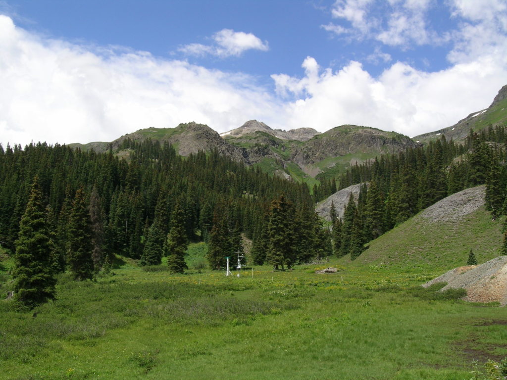
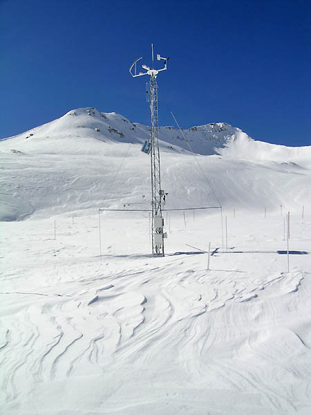
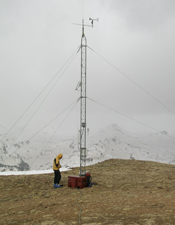
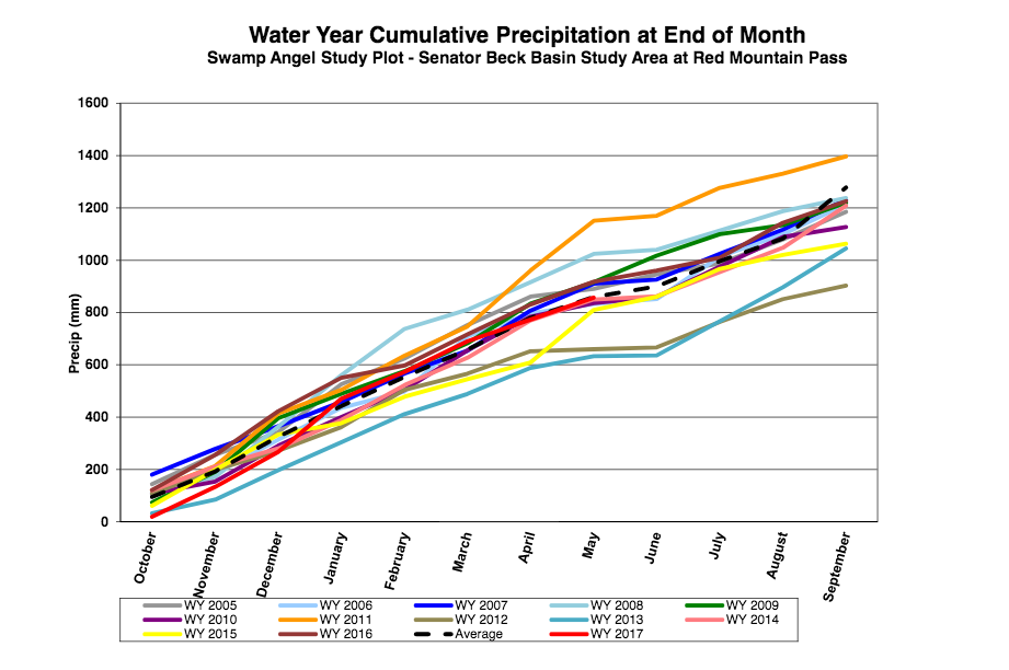